_-_geograph.org.uk_-_811787.jpg)
_-_geograph.org.uk_-_811787.jpg&action=edit&redlink=1)
No higher resolution available.
Belfast_City_Cemetery_(1)_-_geograph.org.uk_-_811787.jpg (640 × 473 pixels, file size: 461 KB, MIME type: image/jpeg)
| This is a file from the Wikimedia Commons. Information from its description page there is shown below. Commons is a freely licensed media file repository. You can help. |
_-_geograph.org.uk_-_811787.jpg)
Summary
| Description |
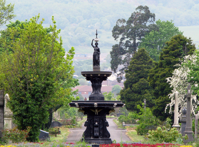
English: Belfast City Cemetery [1] Located off the Falls Road, Belfast City Cemetery is one of the oldest public cemeteries in Belfast and the city's first municipal burial ground. Containing graves and memorials to some of Belfast's most important and wealthiest families, it officially opened on August 1st 1869 and is still in use today. It has separate Catholic and Protestant areas and a section was reserved for Jewish residents in 1874. See http://www.belfastcity.gov.uk/citycemetery/history.asp?menuitem=history for a good history on the development of the cemetery.
The cemetery is split over four grid squares - J3072, J3073, J3173 and J3172 - and this cast iron drinking fountain is almost exactly at the meeting point of all four. The fountain was installed in 1880 by George Smith and Company of the Sun Foundry, Glasgow. |
| Date | |
| Source | From geograph.org.uk |
| Author | Ross |
| Camera location | | View this and other nearby images on: OpenStreetMap |
|---|
_-_geograph.org.uk_-_811787.jpg¶ms=054.588150_N_-005.974700_E_globe:Earth_type:camera_source:geograph-irishgrid(J30977298)_heading:292.00&language=en)
| Object location | | View this and other nearby images on: OpenStreetMap |
|---|
_-_geograph.org.uk_-_811787.jpg¶ms=054.588240_N_-005.975000_E_globe:Earth_class:object_type:object_source:geograph-irishgrid(J30957299)_heading:292.00&language=en)
Licensing

|
This image was taken from the Geograph project collection. See this photograph's page on the Geograph website for the photographer's contact details. The copyright on this image is owned by Ross and is licensed for reuse under the Creative Commons Attribution-ShareAlike 2.0 license.
|
This file is licensed under the Creative Commons Attribution-Share Alike 2.0 Generic license.
Attribution: Ross
- You are free:
- to share – to copy, distribute and transmit the work
- to remix – to adapt the work
- Under the following conditions:
- attribution – You must give appropriate credit, provide a link to the license, and indicate if changes were made. You may do so in any reasonable manner, but not in any way that suggests the licensor endorses you or your use.
- share alike – If you remix, transform, or build upon the material, you must distribute your contributions under the same or compatible license as the original.
File history
Click on a date/time to view the file as it appeared at that time.
| Date/Time | Thumbnail | Dimensions | User | Comment | |
|---|---|---|---|---|---|
| current | 11:24, 20 February 2011 | | 640 × 473 (461 KB) | GeographBot | == {{int:filedesc}} == {{Information |description={{en|1=Belfast City Cemetery [1] Located off the Falls Road, Belfast City Cemetery is one of the oldest public cemeteries in Belfast and the city's first municipal burial ground. Containing graves and memo |
File usage
The following pages on the English Wikipedia use this file (pages on other projects are not listed):
_-_geograph.org.uk_-_811787.jpg)