
Size of this preview: 800 × 515 pixels. Other resolutions: 320 × 206 pixels | 640 × 412 pixels | 862 × 555 pixels.
Original file (862 × 555 pixels, file size: 663 KB, MIME type: image/png)
| This is a file from the Wikimedia Commons. Information from its description page there is shown below. Commons is a freely licensed media file repository. You can help. |
Summary
| Description |
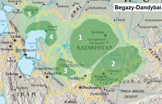
English: Begazy-Dandybai Archaeological Complex
1 = Central Kazakhstan (Center) 2 = Dzhail'ma, Kainda, Sermirech'e 3 = Khorezm (Tagisken) 4 = Northern Caspian 5 = Volgograd (Elena E. Kuzmina: 2007) |
| Date | |
| Source | File:Asia-map.png |
| Author | EnglishAlummah.news |
Licensing
This image is in the public domain because it contains materials that originally came from the United States Central Intelligence Agency's World Factbook.
|
 |
File history
Click on a date/time to view the file as it appeared at that time.
| Date/Time | Thumbnail | Dimensions | User | Comment | |
|---|---|---|---|---|---|
| current | 20:55, 14 September 2019 | | 862 × 555 (663 KB) | Alummah.news | User created page with UploadWizard |
File usage
The following pages on the English Wikipedia use this file (pages on other projects are not listed):
Global file usage
The following other wikis use this file:
- Usage on ru.wikipedia.org