
Original file (1,500 × 1,130 pixels, file size: 866 KB, MIME type: image/png)
| This is a file from the Wikimedia Commons. Information from its description page there is shown below. Commons is a freely licensed media file repository. You can help. |
Summary
| Description |
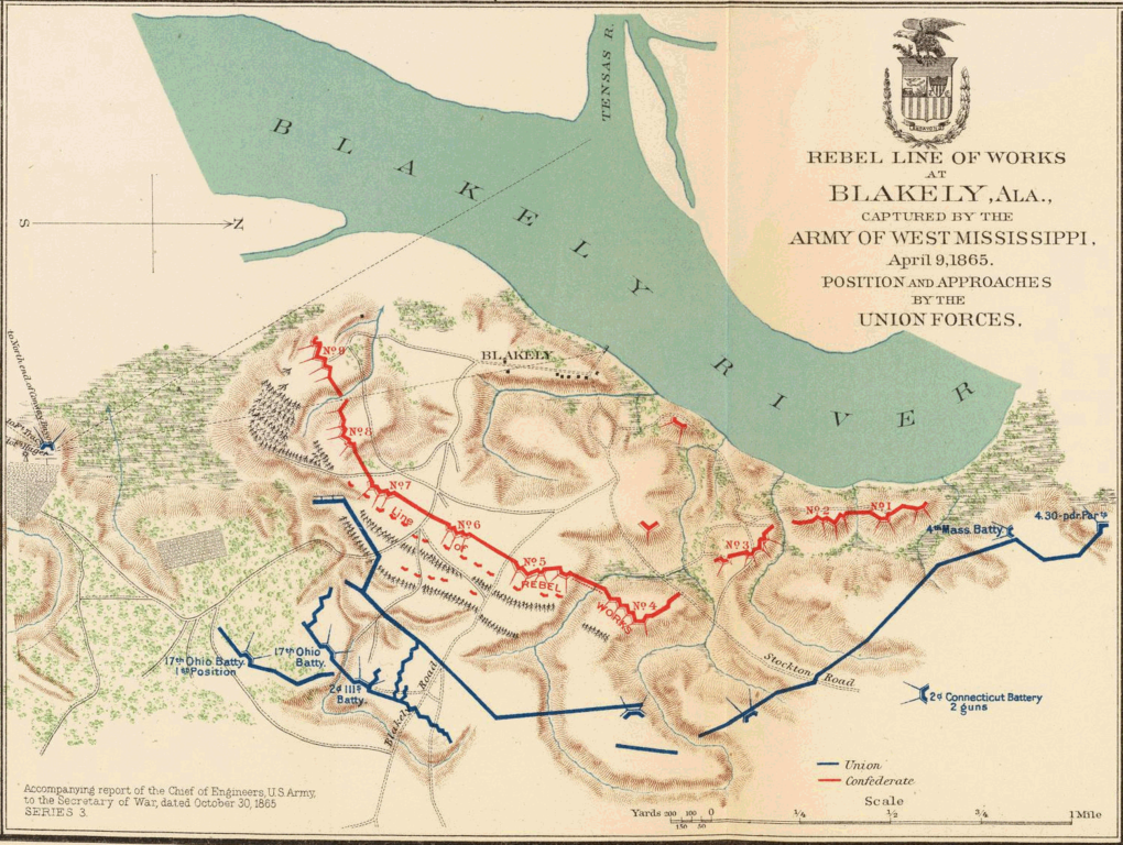
English: Short Title: Mobile, Blakely, Messinger's Ferry-Canton.
Publisher: Washington: U.S. Government Printing Office Three col. maps, with 15 ancillary maps. Relief shown by hachures. Campaign map 11 contains 4 maps. Accompany reports of Chief of Engineers, U.S. Army, A.S. Williams and James B. McPherson. No. 10. Map of the defenses of the city of Mobile. Rebel line of works at Blakely, Ala., captured by the Army of West Mississippi, April 9, 1865. Position and approaches by the Union forces. Expedition from Messinger's Ferry toward Canton, Miss., October 14-20, 1863. (with) Campaign maps, numbers 1 to 11 inclusive, showing position of 20th Army Corps on march from Atlanta, Ga. to Savannah, Ga., with dates and Union and rebel defenses, from surveys of Topographical Engineers 20th Army Corps. Position of troops by Lieut. Col. C.W. Asmussen ... December 1864. (with) Position occupied by troops from French's division at the crossing of the Cattahoochee River. S.G. French, Major-General, C.S. Army. Julius Bien & Co., Lith., N.Y. (1891-1895) Engraver or Printer: Julius Bien & Co. ; Asmussen, Charles W. ; French, Samuel G. Published title: Atlas to accompany the official records of the Union and Confederate armies. Published under the direction of the Hons. Redfield Proctor, Stephen B. Elkins and Daniel S. Lamont, secretaries of war, by Maj. George B. Davis, U.S. Army, Mr. Leslie J. Perry, civilian expert, Mr. Joseph W. Kirkley, civilian expert, Board of Publication. Compiled by Capt. Calvin D. Cowles, 23d U.S. Infantry. Washington: Government Printing Office, 1891-1895. Published reference: LC Civil War maps (2nd ed.), 99; Civil War maps in the National Archives, 8; Phillips, 1353; LeGear. Atlases of the United States, 266. |
| Date | |
| Source |
Source: http://www.davidrumsey.com/ Transferred from en.wikipedia to Commons by User:Innotata using CommonsHelper |
| Author | United States War Department |
Licensing
This work is in the public domain in the United States because it is a work prepared by an officer or employee of the United States Government as part of that person’s official duties under the terms of Title 17, Chapter 1, Section 105 of the US Code.
Note: This only applies to original works of the Federal Government and not to the work of any individual U.S. state, territory, commonwealth, county, municipality, or any other subdivision. This template also does not apply to postage stamp designs published by the United States Postal Service since 1978. (See § 313.6(C)(1) of Compendium of U.S. Copyright Office Practices). It also does not apply to certain US coins; see The US Mint Terms of Use.
|
 | |
| This file has been identified as being free of known restrictions under copyright law, including all related and neighboring rights. | ||
Original upload log
- 2005-01-01 06:19 Brian0918 1500×1130× (886601 bytes) Author: United States. War Department<br>Date: 1895<br>Short Title: Mobile, Blakely, Messinger's Ferry-Canton.<br>Publisher: Washington: U.S. Government Printing Office<br>Three col. maps, with 15 ancillary maps. Relief shown by hachures. Campaign map 11
File history
Click on a date/time to view the file as it appeared at that time.
| Date/Time | Thumbnail | Dimensions | User | Comment | |
|---|---|---|---|---|---|
| current | 18:13, 7 July 2011 | | 1,500 × 1,130 (866 KB) | File Upload Bot (Magnus Manske) | {{BotMoveToCommons|en.wikipedia|year={{subst:CURRENTYEAR}}|month={{subst:CURRENTMONTHNAME}}|day={{subst:CURRENTDAY}}}} {{Information |Description={{en|Short Title: Mobile, Blakely, Messinger's Ferry-Canton. Publisher: Washington: U.S. Government Printing |
File usage
Global file usage
The following other wikis use this file:
- Usage on ar.wikipedia.org
- Usage on es.wikipedia.org