
Size of this PNG preview of this SVG file: 800 × 563 pixels. Other resolutions: 320 × 225 pixels | 640 × 451 pixels | 1,024 × 721 pixels | 1,280 × 901 pixels | 2,560 × 1,803 pixels | 808 × 569 pixels.
Original file (SVG file, nominally 808 × 569 pixels, file size: 181 KB)
| This is a file from the Wikimedia Commons. Information from its description page there is shown below. Commons is a freely licensed media file repository. You can help. |
| Description |
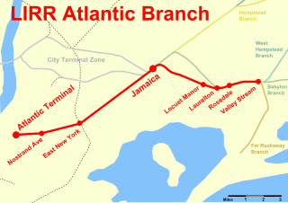
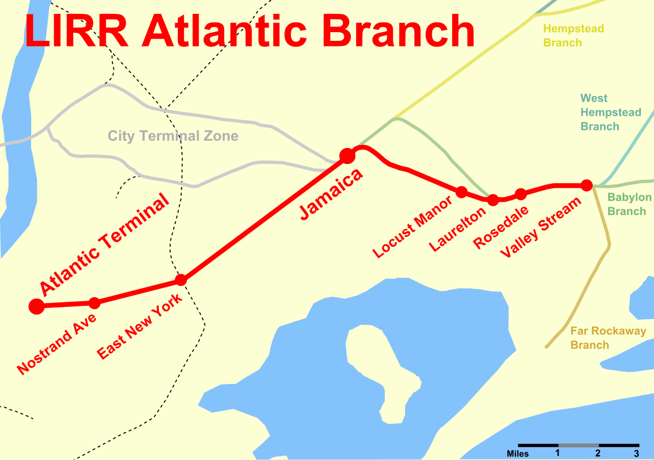
English: A map of the Long Island Rail Road's Atlantic Branch, showing current stations and surrounding branches. |
| Date | (UTC) |
| Source | |
| Author |
|
| This is a retouched picture, which means that it has been digitally altered from its original version. Modifications: vectorized. The original can be viewed here: Atlantic Branch Map.PNG:
|
I, the copyright holder of this work, hereby publish it under the following licenses:
This work is in the public domain in the United States because it is a work prepared by an officer or employee of the United States Government as part of that person’s official duties under the terms of Title 17, Chapter 1, Section 105 of the US Code.
Note: This only applies to original works of the Federal Government and not to the work of any individual U.S. state, territory, commonwealth, county, municipality, or any other subdivision. This template also does not apply to postage stamp designs published by the United States Postal Service since 1978. (See § 313.6(C)(1) of Compendium of U.S. Copyright Office Practices). It also does not apply to certain US coins; see The US Mint Terms of Use.
|
 | |
| This file has been identified as being free of known restrictions under copyright law, including all related and neighboring rights. | ||
| I, the copyright holder of this work, release this work into the public domain. This applies worldwide. In some countries this may not be legally possible; if so: I grant anyone the right to use this work for any purpose, without any conditions, unless such conditions are required by law. |
You may select the license of your choice.
Original upload log
This image is a derivative work of the following images:
- File:Atlantic_Branch_Map.PNG licensed with Cc-pd-mark-footer, PD-USGov, PD-retouched-user
- 2011-04-10T00:56:05Z Pi.1415926535 808x569 (78102 Bytes) {{Information |Description ={{en|1=A map of the Long Island Rail Road's [[:en:Atlantic Branch|Atlantic Branch]], showing current stations and surrounding branches.}} |Source =The original map came from [[:en:Nation
Uploaded with derivativeFX
File history
Click on a date/time to view the file as it appeared at that time.
| Date/Time | Thumbnail | Dimensions | User | Comment | |
|---|---|---|---|---|---|
| current | 23:11, 26 July 2011 | | 808 × 569 (181 KB) | Pi.1415926535 | Changed Flatbush Ave to Atlantic Terminal |
| 03:50, 26 July 2011 |  | 808 × 569 (178 KB) | Pi.1415926535 | Fixed text rendering | |
| 03:48, 26 July 2011 |  | 808 × 569 (162 KB) | Pi.1415926535 | {{Information |Description={{en|1=A map of the Long Island Rail Road's Atlantic Branch, showing current stations and surrounding branches.}} |Source=*File:Atlantic_Branch_Map.PNG |Date=2011-07-26 03:46 (UTC) |Author=*[[:File: |
File usage
The following pages on the English Wikipedia use this file (pages on other projects are not listed):
Global file usage
The following other wikis use this file:
- Usage on ja.wikipedia.org
- Usage on www.wikidata.org