No higher resolution available.
Astley_signalbox.jpg (640 × 427 pixels, file size: 75 KB, MIME type: image/jpeg)
| This is a file from the Wikimedia Commons. Information from its description page there is shown below. Commons is a freely licensed media file repository. You can help. |
Summary
| Description |
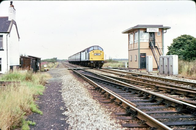
English: Astley signalbox 1979. A Manchester Victoria to Llandudno train passes over the level crossing at Astley on Chat Moss in August 1979. The houses on the left were originally for the crossing keepers who were effectively marooned in the middle of the Moss. |
| Date | |
| Source | From geograph.org.uk |
| Author | Peter Whatley |
| Permission (Reusing this file) |
Creative Commons Attribution Share-alike license 2.0 |
| Camera location | | View this and other nearby images on: OpenStreetMap |
|---|
Licensing

|
This image was taken from the Geograph project collection. See this photograph's page on the Geograph website for the photographer's contact details. The copyright on this image is owned by Peter Whatley and is licensed for reuse under the Creative Commons Attribution-ShareAlike 2.0 license.
|
This file is licensed under the Creative Commons Attribution-Share Alike 2.0 Generic license.
Attribution: Peter Whatley
- You are free:
- to share – to copy, distribute and transmit the work
- to remix – to adapt the work
- Under the following conditions:
- attribution – You must give appropriate credit, provide a link to the license, and indicate if changes were made. You may do so in any reasonable manner, but not in any way that suggests the licensor endorses you or your use.
- share alike – If you remix, transform, or build upon the material, you must distribute your contributions under the same or compatible license as the original.
Original upload log
The original description page was here. All following user names refer to en.wikipedia.
| Upload date | User | Bytes | Dimensions | Comment |
|---|---|---|---|---|
| 2010-03-18 21:36:15 | J3Mrs | 77280 | 640×427 | == {{int:filedesc}} == {{Information |Description={{en|1=Astley signalbox 1979}} |Source=From [http://www.geograph.org.uk/photo/811889 geograph.org.uk] |Date=1979-08 |Author=[http://www.geograph.org.uk/profile/25788 Peter Whatley] |Permission=Creative Commons Attribution Share-alike license 2.0 }} {{Location dec|53.470868|-2.449496|heading:135}} == {{int:license}} == {{geograph|811889|Peter Whatley}} |
File history
Click on a date/time to view the file as it appeared at that time.
| Date/Time | Thumbnail | Dimensions | User | Comment | |
|---|---|---|---|---|---|
| current | 19:27, 20 March 2010 | | 640 × 427 (75 KB) | CommonsHelper2 Bot | {{BotMoveToCommons|en.wikipedia|year={{subst:CURRENTYEAR}}|month={{subst:CURRENTMONTHNAME}}|day={{subst:CURRENTDAY}}}} == {{int:filedesc}} == {{Information |Description = {{en|{{en|Astley signalbox 1979}}}} |Source = From [http://www.geograph.org.uk/phot |
File usage
The following pages on the English Wikipedia use this file (pages on other projects are not listed):
Global file usage
The following other wikis use this file:
- Usage on www.wikidata.org