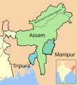
Size of this PNG preview of this SVG file: 591 × 600 pixels. Other resolutions: 236 × 240 pixels | 473 × 480 pixels | 757 × 768 pixels | 1,009 × 1,024 pixels | 2,018 × 2,048 pixels | 606 × 615 pixels.
Original file (SVG file, nominally 606 × 615 pixels, file size: 2.25 MB)
File history
Click on a date/time to view the file as it appeared at that time.
| Date/Time | Thumbnail | Dimensions | User | Comment | |
|---|---|---|---|---|---|
| current | 16:41, 21 December 2019 |  | 606 × 615 (2.25 MB) | Furfur | font fix |
| 20:43, 11 March 2017 |  | 606 × 615 (1.14 MB) | Furfur | die richtige Einschubkarte | |
| 20:13, 11 March 2017 |  | 606 × 615 (1.5 MB) | Furfur | Kosmetik | |
| 20:11, 11 March 2017 |  | 606 × 615 (1.5 MB) | Furfur | correction: Naga tribal area | |
| 19:35, 11 March 2017 |  | 606 × 615 (1.5 MB) | Furfur | größere Schrift | |
| 10:45, 17 January 2015 |  | 577 × 634 (931 KB) | Furfur | Sikkim | |
| 20:03, 16 January 2015 |  | 577 × 634 (932 KB) | Furfur | Detail | |
| 19:57, 16 January 2015 |  | 577 × 634 (932 KB) | Furfur | Detail | |
| 19:34, 16 January 2015 |  | 577 × 634 (933 KB) | Furfur | borderline of Manipur smaller | |
| 17:53, 6 January 2015 |  | 577 × 634 (933 KB) | Furfur | Korrektur |
File usage
The following pages on the English Wikipedia use this file (pages on other projects are not listed):
Global file usage
The following other wikis use this file:
- Usage on de.wikipedia.org
- Usage on es.wikipedia.org
- Usage on kn.wikipedia.org


