No higher resolution available.
Artigas_statue_map.jpg (711 × 404 pixels, file size: 419 KB, MIME type: image/jpeg)
| This is a file from the Wikimedia Commons. Information from its description page there is shown below. Commons is a freely licensed media file repository. You can help. |
Summary
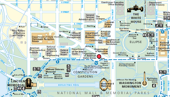
| Description |
English: Map of Washington, DC, marking location of statue of Jose Gervasio Artigas |
| Date | 11 April 2006, modified 2 May 2006, modified 5 October 2008 |
| Source | http://www.nps.gov/PWR/state/DC/upload/NPS-Map-Washington-DC.pdf |
| Author | National Park Service, llywelynII |
| Camera location | | View this and other nearby images on: OpenStreetMap |
|---|
Licensing
| This image or media file contains material based on a work of a National Park Service employee, created as part of that person's official duties. As a work of the U.S. federal government, such work is in the public domain in the United States. See the NPS website and NPS copyright policy for more information. |
File history
Click on a date/time to view the file as it appeared at that time.
| Date/Time | Thumbnail | Dimensions | User | Comment | |
|---|---|---|---|---|---|
| current | 07:04, 5 October 2008 | | 711 × 404 (419 KB) | LlywelynII | {{Information |Description={{en|1=Map of Washington, DC, marking location of statue of Jose Gervasio Artigas}} |Source=http://www.nps.gov/PWR/state/DC/upload/NPS-Map-Washington-DC.pdf |Author=National Park Service, llywelynII |Date=11 April 2006, modified |
File usage
The following pages on the English Wikipedia use this file (pages on other projects are not listed):
Global file usage
The following other wikis use this file:
- Usage on ru.wikipedia.org
- Usage on uk.wikipedia.org