No higher resolution available.
Arrondissement_de_Marseille.PNG (556 × 478 pixels, file size: 17 KB, MIME type: image/png)
| This is a file from the Wikimedia Commons. Information from its description page there is shown below. Commons is a freely licensed media file repository. You can help. |
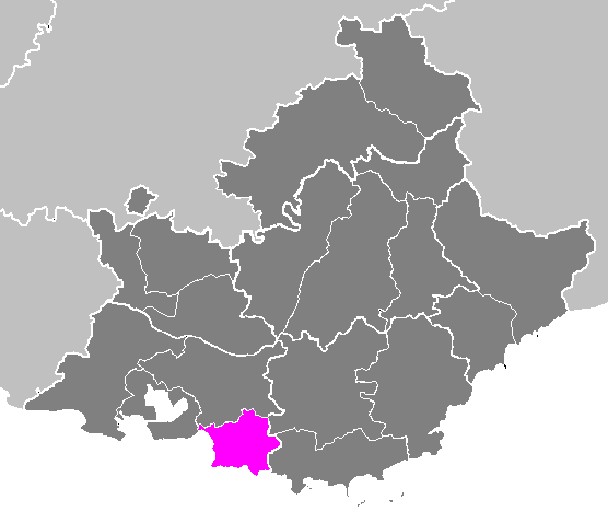
| Description | Locator map of the arrondissement of Istres (before 2018) in Bouches-du-Rhône and Provence-Alpes-Côte d'Azur (France). | ||
| Date | |||
| Source | Own work | ||
| Author | M.Minderhoud | ||
| Permission (Reusing this file) |
|
File history
Click on a date/time to view the file as it appeared at that time.
| Date/Time | Thumbnail | Dimensions | User | Comment | |
|---|---|---|---|---|---|
| current | 17:59, 22 November 2006 | | 556 × 478 (17 KB) | Michiel1972 | {{Information |Description= Maps of arrondissements and cantons of France: {{subst:PAGENAME}} |Source= |Date=november 2006 |Author= M.Minderhoud |Permission= {{PD-self}} |other_versions= }} [[Category:Maps of arrondisseme |
File usage
No pages on the English Wikipedia use this file (pages on other projects are not listed).
Global file usage
The following other wikis use this file:
- Usage on arz.wikipedia.org
- Usage on cs.wikipedia.org
- Usage on es.wikipedia.org
- Usage on fa.wikipedia.org
- Usage on hy.wikipedia.org
- Usage on ia.wikipedia.org
- Usage on id.wikipedia.org
- Usage on kk.wikipedia.org
- Usage on lb.wikipedia.org
- Usage on mt.wikipedia.org
- Usage on nl.wikipedia.org
- Usage on ru.wikipedia.org
- Usage on sco.wikipedia.org
- Usage on sk.wikipedia.org
- Usage on www.wikidata.org