
Size of this PNG preview of this SVG file: 417 × 272 pixels. Other resolutions: 320 × 209 pixels | 640 × 417 pixels | 1,024 × 668 pixels | 1,280 × 835 pixels | 2,560 × 1,670 pixels.
Original file (SVG file, nominally 417 × 272 pixels, file size: 51 KB)
| This is a file from the Wikimedia Commons. Information from its description page there is shown below. Commons is a freely licensed media file repository. You can help. |
| Description |
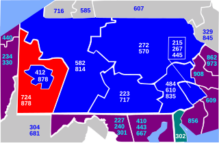
English: Map of Pennsylvania area codes in blue with 724/878 in red |
||
| Date | |||
| Source | Self, traced from original PNG created by self. | ||
| Author | Paul Robinson (Rfc1394) at en.wikipedia | ||
| Permission (Reusing this file) |
Released into the public domain (by the author);
|
||
| Other versions | Note: If you need to change the area codes this map displays, be advised that a "master-satellite" map mode is being used. Additionally, a CSS Style Sheet is embedded in the svg to allow easier changes. Instead of making changes to the area codes listed on each of the individual area code maps, yo only have to edit the master map, file:Area codes PA.svg, using Inkscape or any other SVG editor, then save. Now, using a text editor, for each file, you only have to edit one lineto change the CSS color for that individual Pennsylvania area code region, then save each specific map under the following names: file:Area code 215.svg, file:Area code 412.svg, file:Area code 484.svg, file:Area code 570.svg, file:Area code 717.svg, file:Area code 724.svg, file:Area code 814.svg, and file:Area code 878.svg, and then re-upload all of them. This will make sure you change all Pennsylvania Area Code Map Files, they're identically sized so the clickable map works correctly on all of them, and they remain in sync. |
File history
Click on a date/time to view the file as it appeared at that time.
| Date/Time | Thumbnail | Dimensions | User | Comment | |
|---|---|---|---|---|---|
| current | 12:59, 3 July 2023 | | 417 × 272 (51 KB) | Rfc1394 | Add new and changed area codes inside & outside PA and change styles to use CSS; make DE area code 302 easier to read |
| 23:15, 9 January 2018 |  | 417 × 272 (48 KB) | Rfc1394 | Correct WV to 304/681 NOT 304/661 | |
| 18:30, 10 April 2017 |  | 391 × 255 (44 KB) | Rfc1394 | To convert to new "master-satellite" map format | |
| 15:51, 9 April 2017 |  | 391 × 255 (43 KB) | Rfc1394 | Add new area codes, drop unused one | |
| 19:28, 25 June 2014 |  | 391 × 255 (42 KB) | Rfc1394 | Correct WV from 304/661 to 304/681 | |
| 00:40, 18 August 2012 |  | 391 × 255 (42 KB) | Rfc1394 | {{Information |Description ={{en|1=A}} |Source ={{own}} |Author =Rfc1394 |Date = |Permission = |other_versions = }} {{Information |Description={{en|Map of Pennsylvania area codes in blue with 724/878 in... |
File usage
The following pages on the English Wikipedia use this file (pages on other projects are not listed):
Global file usage
The following other wikis use this file:
- Usage on es.wikipedia.org