.png)
.png&action=edit&redlink=1)

Size of this preview: 800 × 523 pixels. Other resolutions: 320 × 209 pixels | 640 × 419 pixels | 1,024 × 670 pixels | 1,280 × 837 pixels | 1,783 × 1,166 pixels.
Original file (1,783 × 1,166 pixels, file size: 2.35 MB, MIME type: image/png)
| This is a file from the Wikimedia Commons. Information from its description page there is shown below. Commons is a freely licensed media file repository. You can help. |
.png)
Summary
| Description |
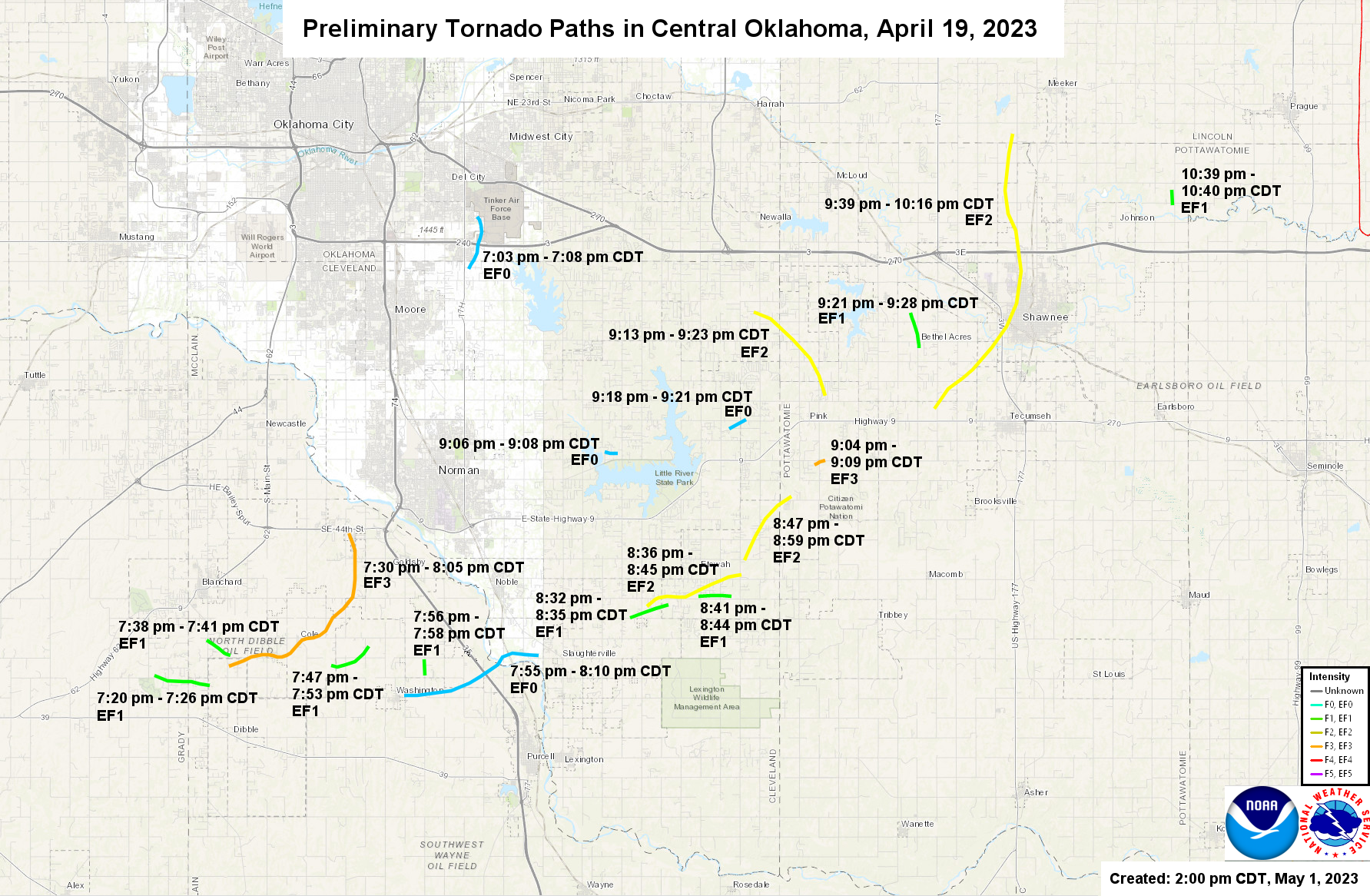
English: The tornadoes surveyed by the National Weather Service of Norman, Oklahoma for April 19, 2023. This map was updated at 4:30 PM CDT on April 21, 2023. |
| Date | |
| Source | https://www.weather.gov/oun/events-20230419 (Exact URL & Archived URL) |
| Author | National Weather Service |
Licensing
This image is in the public domain because it was stored on the web servers of the U.S. National Weather Service. NWS-created images are automatically public domain in the U.S. since the NWS is a part of the U.S. government. However, the NWS sites also host non-NWS images which have been submitted by individuals: these are generally shown as "Courtesy of ...". Such images have explicitly been released to the public domain by the copyright owner as part of the upload process.
As stated at https://www.weather.gov/fsd/disclaimer: "By submitting images, you understand that your image is being released into the public domain. This means that your photo or video may be downloaded, copied, and used by others." Thus, all* images on NWS servers are public domain (including "Courtesy of ..." and “Photo by ...” images) unless specifically stated otherwise through a copyright (©) watermark.
*A deletion discussion in November 2023 ruled that Getty Images on the web servers of NWS, are to be considered copyrighted, even without a copyright (©) watermark and are the sole exception to this rule.
|
File history
Click on a date/time to view the file as it appeared at that time.
| Date/Time | Thumbnail | Dimensions | User | Comment | |
|---|---|---|---|---|---|
| current | 19:50, 4 June 2023 | | 1,783 × 1,166 (2.35 MB) | Cyclonebiskit | May 1 update |
| 21:57, 21 April 2023 |  | 1,454 × 938 (1.59 MB) | WeatherWriter | Uploaded a work by National Weather Service from https://www.weather.gov/oun/events-20230419 ([https://www.weather.gov/images/oun/wxevents/20230419/maps/20230419-tornadopaths.png Exact URL] & [https://web.archive.org/web/20230421215343/https://www.weather.gov/images/oun/wxevents/20230419/maps/20230419-tornadopaths.png Archived URL]) with UploadWizard |
File usage
The following pages on the English Wikipedia use this file (pages on other projects are not listed):
.png)