No higher resolution available.
Ancient_Levant_routes1.png (350 × 410 pixels, file size: 91 KB, MIME type: image/png)
| This is a file from the Wikimedia Commons. Information from its description page there is shown below. Commons is a freely licensed media file repository. You can help. |
Summary
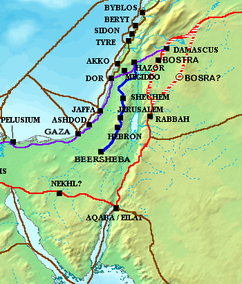
| Description |
English: Way of the Patriarchs (blue), Via Maris (purple), King's Highway (red), and other ancient Levantine trade routes (brown), c. en:1300 BCE עברית: דרך ההר (כחול), דרך הים (סגול), דרך המלך (אדום), ודרכי מסחר עתיקות נוספות (חום) |
| Date | |
| Source | Original version of map (File:Ancient Levant routes.png) (not including Way of the Patriarchs in blue) was created by Briangotts |
| Author | Atefrat |
Licensing
I, the copyright holder of this work, hereby publish it under the following license:
This file is licensed under the Creative Commons Attribution-Share Alike 3.0 Unported license.
- You are free:
- to share – to copy, distribute and transmit the work
- to remix – to adapt the work
- Under the following conditions:
- attribution – You must give appropriate credit, provide a link to the license, and indicate if changes were made. You may do so in any reasonable manner, but not in any way that suggests the licensor endorses you or your use.
- share alike – If you remix, transform, or build upon the material, you must distribute your contributions under the same or compatible license as the original.
File history
Click on a date/time to view the file as it appeared at that time.
| Date/Time | Thumbnail | Dimensions | User | Comment | |
|---|---|---|---|---|---|
| current | 08:23, 9 January 2012 | | 350 × 410 (91 KB) | Atefrat |
File usage
The following pages on the English Wikipedia use this file (pages on other projects are not listed):
Global file usage
The following other wikis use this file:
- Usage on bn.wikipedia.org
- Usage on da.wikipedia.org
- Usage on he.wikipedia.org