
Size of this preview: 800 × 577 pixels. Other resolutions: 320 × 231 pixels | 640 × 462 pixels | 1,024 × 739 pixels.
Original file (1,024 × 739 pixels, file size: 162 KB, MIME type: image/jpeg)
| This is a file from the Wikimedia Commons. Information from its description page there is shown below. Commons is a freely licensed media file repository. You can help. |
Summary
| Description |
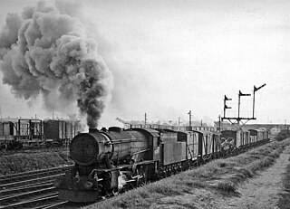
English: Eastbound freight on North Mersey line passing site of Ford Station and Aintree Sorting Sidings. View westwards near Sefton Junction, towards North Mersey Goods, Gladstone Dock and Liverpool Exchange via Linacre Road; ex-Lancashire & Yorkshire line. Ford station (closed 2/4/51) was this side of the A5038 bridge in the distance; Aintree SS are across on the south side of the line. The locomotive on the Class F freight is ex-War Department 2-8-0 No. 90557: note that it is fitted with a snow-plough - in mid-June. |
| Date | Taken on 12 June 1959 |
| Source | From geograph.org.uk |
| Author | Ben Brooksbank |
| Permission (Reusing this file) |
Creative Commons Attribution Share-alike license 2.0 |
| Attribution (required by the license) | Ben Brooksbank / Eastbound freight on North Mersey line passing site of Ford Station and Aintree Sorting Sidings / |
| Camera location | | View this and other nearby images on: OpenStreetMap |
|---|
_heading:270.00&language=en)
| Object location | | View this and other nearby images on: OpenStreetMap |
|---|
_heading:270.00&language=en)
Licensing

|
This image was taken from the Geograph project collection. See this photograph's page on the Geograph website for the photographer's contact details. The copyright on this image is owned by Ben Brooksbank and is licensed for reuse under the Creative Commons Attribution-ShareAlike 2.0 license.
|
This file is licensed under the Creative Commons Attribution-Share Alike 2.0 Generic license.
Attribution: Ben Brooksbank
- You are free:
- to share – to copy, distribute and transmit the work
- to remix – to adapt the work
- Under the following conditions:
- attribution – You must give appropriate credit, provide a link to the license, and indicate if changes were made. You may do so in any reasonable manner, but not in any way that suggests the licensor endorses you or your use.
- share alike – If you remix, transform, or build upon the material, you must distribute your contributions under the same or compatible license as the original.
File history
Click on a date/time to view the file as it appeared at that time.
| Date/Time | Thumbnail | Dimensions | User | Comment | |
|---|---|---|---|---|---|
| current | 17:10, 8 November 2010 | | 1,024 × 739 (162 KB) | Chevin | == {{int:filedesc}} == {{Information |Description={{en|1=Eastbound freight on North Mersey line approaching Fazakerley Junction View westward, towards Aintree and the North Mersey line, ex-Lancashire & Yorkshire: Aintree Sorting Sidings are on the left, t |
File usage
The following pages on the English Wikipedia use this file (pages on other projects are not listed):
Global file usage
The following other wikis use this file:
- Usage on www.wikidata.org