File:A map of the countries between Constantinople and Calcutta - including Turkey in Asia, Persia, Afghanistan & Turkestan. LOC 2013593023.jpg

Size of this preview: 800 × 589 pixels. Other resolutions: 320 × 235 pixels | 640 × 471 pixels | 1,024 × 753 pixels | 1,280 × 942 pixels | 2,560 × 1,883 pixels | 11,050 × 8,129 pixels.
Original file (11,050 × 8,129 pixels, file size: 16.05 MB, MIME type: image/jpeg)
| This is a file from the Wikimedia Commons. Information from its description page there is shown below. Commons is a freely licensed media file repository. You can help. |
Summary
| Warning | The original file is very high-resolution. It might not load properly or could cause your browser to freeze when opened at full size. |
|---|
| Description |
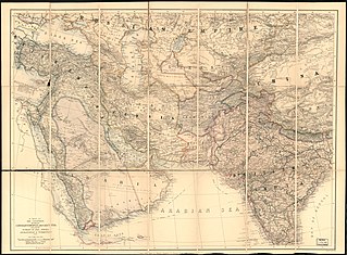
English: Shows railroads, submarine telegraphs, and boundaries of British possessions colored in red. Relief shown by hachures and spot heights. "Stanford's Geogl. Establ." Includes distance table between cities in Britain, France and Egypt. Available also through the Library of Congress Web site as a raster image. |
||
| Title | A map of the countries between Constantinople and Calcutta : including Turkey in Asia, Persia, Afghanistan & Turkestan. | ||
| Shelf ID | G7420 1885 .E3 | ||
| Date | |||
| Source | https://www.loc.gov/item/2013593023/ | ||
| Author | Edward Stanford Ltd | ||
| Permission (Reusing this file) |
|
||
| Other versions |
|
||
| Location | Eastern Europe · South Asia · Middle East | ||
| Part of | American Memory · General Maps · Catalog · Geography And Map Division | ||
| Subject | Eastern Europe · Maps · Europe, Eastern · Middle East · South Asia |


Licensing
|
This is a faithful photographic reproduction of a two-dimensional, public domain work of art. The work of art itself is in the public domain for the following reason:
The official position taken by the Wikimedia Foundation is that "faithful reproductions of two-dimensional public domain works of art are public domain".
This photographic reproduction is therefore also considered to be in the public domain in the United States. In other jurisdictions, re-use of this content may be restricted; see Reuse of PD-Art photographs for details. | ||||
File history
Click on a date/time to view the file as it appeared at that time.
| Date/Time | Thumbnail | Dimensions | User | Comment | |
|---|---|---|---|---|---|
| current | 16:09, 25 May 2018 | | 11,050 × 8,129 (16.05 MB) | Fæ | LOC Maps https://www.loc.gov/item/2013593023/ #15023 |
File usage
The following pages on the English Wikipedia use this file (pages on other projects are not listed):