File:AERIAL VIEW OF TELLURIDE SHOWING NEWLY-CUT SKI TRAILS (IN RIGHT FOREGROUND - NARA - 543746.jpg

Original file (1,953 × 2,907 pixels, file size: 2.38 MB, MIME type: image/jpeg)
| This is a file from the Wikimedia Commons. Information from its description page there is shown below. Commons is a freely licensed media file repository. You can help. |
Summary
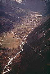
| English: Aerial view of Telluride showing newly-cut ski trails (in right foreground)
( |
|||||||||||||||||||||||||||
|---|---|---|---|---|---|---|---|---|---|---|---|---|---|---|---|---|---|---|---|---|---|---|---|---|---|---|---|
| Author |
Gillette, Bill, 1932-, Photographer (NARA record: 8464444) |
||||||||||||||||||||||||||
| Record creator | Environmental Protection Agency. (12/02/1970 - ) | ||||||||||||||||||||||||||
| Title |
English: Aerial view of Telluride showing newly-cut ski trails (in right foreground) |
||||||||||||||||||||||||||
| Depicted place |
Telluride (San Miguel, Colorado, United States, North and Central America) inhabited place (37°55′59″N 107°48′00″W / 37.933°N 107.8°W; NARA geographical record) |
||||||||||||||||||||||||||
| Date | May 1972 | ||||||||||||||||||||||||||
| Collection |
|
||||||||||||||||||||||||||
| Record ID |
NAIL Control Number: NWDNS-412-DA-1253
|
||||||||||||||||||||||||||
| Source | U.S. National Archives and Records Administration | ||||||||||||||||||||||||||
| Other versions |
Please do not overwrite this file: any restoration work should be uploaded with a new name and linked in this page's "other versions=" parameter, so that this file represents the exact file found in the NARA catalog record to which it links. The metadata on this page was imported directly from NARA's catalog record; additional descriptive text may be added by Wikimedians to the template below with the "description=" parameter, but please do not modify the other fields.
|
||||||||||||||||||||||||||


| Camera location | | View this and other nearby images on: OpenStreetMap |
|---|
Licensing
This file was provided to Wikimedia Commons by the National Archives and Records Administration as part of a cooperation project. The National Archives and Records Administration provides images depicting American and global history which are public domain or licensed under a free license.
|
This image (or other media) is a work of an Environmental Protection Agency employee, taken or made as part of that person's official duties. As works of the U.S. federal government, all EPA images are in the public domain.
|
||
File history
Click on a date/time to view the file as it appeared at that time.
| Date/Time | Thumbnail | Dimensions | User | Comment | |
|---|---|---|---|---|---|
| current | 03:06, 27 April 2012 | | 1,953 × 2,907 (2.38 MB) | Ras67 | 0.5 degree ccw rotated, cropped and colors/gradation adjusted from the TIFF original |
| 08:10, 9 October 2011 |  | 2,057 × 3,000 (1.23 MB) | US National Archives bot | == {{int:filedesc}} == {{NARA-image-full | Title = AERIAL VIEW OF TELLURIDE SHOWING NEWLY-CUT SKI TRAILS (IN RIGHT FOREGROUND | Scope and content = | General notes = | ARC = 543746 | Local iden |
File usage
Global file usage
The following other wikis use this file:
- Usage on he.wikipedia.org
- Usage on ja.wikipedia.org