
Size of this preview: 800 × 577 pixels. Other resolutions: 320 × 231 pixels | 640 × 462 pixels | 1,024 × 739 pixels | 1,280 × 924 pixels | 2,560 × 1,848 pixels | 4,000 × 2,887 pixels.
Original file (4,000 × 2,887 pixels, file size: 12.4 MB, MIME type: image/png)
Summary edit
| Description |
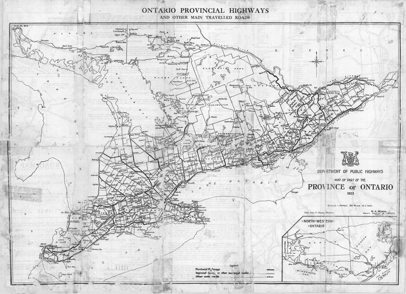
The 1923 Ontario Road Map, the first published map of provincial highways in Ontario | |||
|---|---|---|---|---|
| Source |
Archives of Ontario, RG 14-100-0-0-1, I0050469 | |||
| Date |
1923 | |||
| Author |
Ontario Department of Public Highways | |||
| Permission (Reusing this file) |
| |||
| Other versions | File:1923 Ontario Road Map rear.png (rear side of map) |
| The uploader or another editor requests that a local copy of this file be kept. This image or media file may be available on the Wikimedia Commons as File:1923 Ontario Road Map.png. While the license of this file may be compliant with the Wikimedia Commons, an editor has requested that the local copy be kept too. This file does not meet CSD F8 and should not be tagged as a Commons duplicate. If you desire to nominate it for deletion, notify the tagging editor. |
File history
Click on a date/time to view the file as it appeared at that time.
| Date/Time | Thumbnail | Dimensions | User | Comment | |
|---|---|---|---|---|---|
| current | 17:02, 6 March 2021 | | 4,000 × 2,887 (12.4 MB) | Floydian (talk | contribs) | == Summary == {{Information | description = The 1923 Ontario Road Map, the first published map of provincial highways in Ontario | source = [http://ao.minisisinc.com/scripts/mwimain.dll/144/IMAGES/IMAGES_SUM_REP/FREFCODE%20RG%2014-100?SESSIONSEARCH&fbclid=IwAR2k81hp0EfpCOPEUFYA3w-W7mGpwUFpUCHrcXcH5oa6CDzyiGsbwbhzkbs Archives of Ontario] | date = 1923 | author = Ontario Department of Public Highways | permission = {{PD-Canada-Crown}} | o... |
You cannot overwrite this file.
File usage
The following file is a duplicate of this file (more details):
- File:1923 Ontario Road Map.png from Commons
The following pages on the English Wikipedia use this file (pages on other projects are not listed):