Size of this preview: 442 × 599 pixels. Other resolutions: 177 × 240 pixels | 521 × 706 pixels.
Original file (521 × 706 pixels, file size: 204 KB, MIME type: image/png)
| This is a file from the Wikimedia Commons. Information from its description page there is shown below. Commons is a freely licensed media file repository. You can help. |
Summary
| Description |
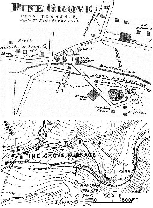
English: 1872 F. W. Beers & Co. layout sketch (top) of Pine Grove Iron Works and 1889 topographic map (bottom) of the greater area by Ambrose E. Lehman, railroad Chief Engineer. The top map labels the distributary from "Mountain Creek" for the furnace's water race north of the "South Mountain R.R.", while Lehman's label for the natural creek in the topographic swale (south of the railroad) was "Mountain" Creek (to right off of this image). The images depict a similar road curve (now Bendersville Rd) over a stream (left side), but depict the RR bridge over the creek in different directions from the ore bed/banks. |
| Date | |
| Source | 1872 F. W. Beers & Co. |
| Author | F. W. Beers & Co. |
| Camera location | | View this and other nearby images on: OpenStreetMap |
|---|
Licensing
This media file is in the public domain in the United States. This applies to U.S. works where the copyright has expired, often because its first publication occurred prior to January 1, 1929, and if not then due to lack of notice or renewal. See this page for further explanation.
|
 | |
 |
This image might not be in the public domain outside of the United States; this especially applies in the countries and areas that do not apply the rule of the shorter term for US works, such as Canada, Mainland China (not Hong Kong or Macao), Germany, Mexico, and Switzerland. The creator and year of publication are essential information and must be provided. See Wikipedia:Public domain and Wikipedia:Copyrights for more details.
|
Original upload log
The original description page was here. All following user names refer to en.wikipedia.
| Date/Time | Dimensions | User | Comment |
|---|---|---|---|
| 2011-06-21 01:50 | 521×706× (208642 bytes) | Target for Today | 1872 F. W. Beers & Co. layout sketch (top) of [[:en:Pine Grove Iron Works|]] and 1889 topographic map (bottom) of the greater area by Ambrose E. Lehman, railroad Chief Engineer. The top map labels the distributary from "[[:en:Mountain Creek (Yellow Breech |
- ↑ Cite error: Invalid
<ref>tag; no text was provided for refs namedBeers - ↑ (Way includes the 1889 Lehman map)
File history
Click on a date/time to view the file as it appeared at that time.
| Date/Time | Thumbnail | Dimensions | User | Comment | |
|---|---|---|---|---|---|
| current | 08:41, 19 March 2015 | | 521 × 706 (204 KB) | Awksauce | Transferred from en.wikipedia |
File usage
The following pages on the English Wikipedia use this file (pages on other projects are not listed):