File:1865 Spruner Map of the World under the Persian Empire - Geographicus - OrbisTerrarumPersici-spruner-1865.jpg
Size of this preview: 760 × 600 pixels. Other resolutions: 304 × 240 pixels | 608 × 480 pixels | 973 × 768 pixels | 1,280 × 1,010 pixels | 2,560 × 2,021 pixels | 3,500 × 2,763 pixels.
Original file (3,500 × 2,763 pixels, file size: 2.43 MB, MIME type: image/jpeg)
| This is a file from the Wikimedia Commons. Information from its description page there is shown below. Commons is a freely licensed media file repository. You can help. |
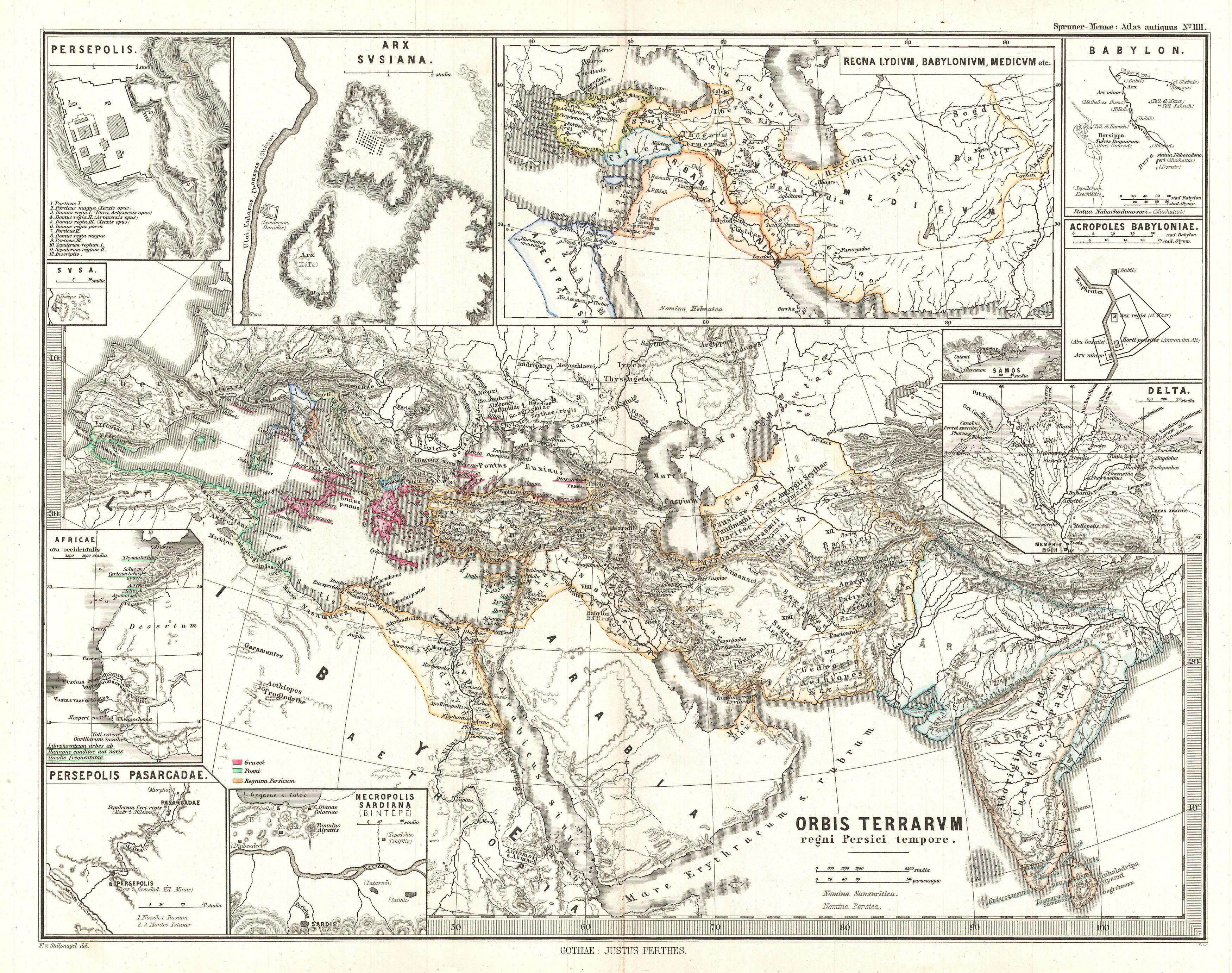
| Karl Spruner von Merz: Orbis Terrarvm regni Persici tempore
( |
||||||||||||||||||||
|---|---|---|---|---|---|---|---|---|---|---|---|---|---|---|---|---|---|---|---|---|
| Artist |
|
|||||||||||||||||||
| Title |
Orbis Terrarvm regni Persici tempore |
|||||||||||||||||||
| Description |
English: This is Karl von Spruner’s 1865 map of The World at the Time of the Persian Empire with eleven insets. The insets (starting clockwise from the upper-left quadrant) feature “Persepolis”, “Arx Susiana”, “the Kingdoms of Lydia, Babylon, and Media”, “Babylon”, “The Acropolis of Babylon”, “The Nile Delta”, “Samos”, “The Burial Grounds at Sardis”, “Persepolis –Pasargadae”, “Africa: The West Coast” and “Sush”. Countries and territories outlined in color. The whole is rendered in finely engraved detail exhibiting throughout the fine craftsmanship of the Perthes firm. |
|||||||||||||||||||
| Date | 1865 (undated) | |||||||||||||||||||
| Dimensions | height: 13 in (33 cm); width: 16 in (40.6 cm) | |||||||||||||||||||
| Accession number |
Geographicus link: OrbisTerrarumPersici-spruner-1865 |
|||||||||||||||||||
| Source/Photographer |
Spruner, Karl von, Spruner-Menke Atlas Antiquus,, (Gotha: Justus Perthes), 1865.
|
|||||||||||||||||||
| Permission (Reusing this file) |
|
|||||||||||||||||||
File history
Click on a date/time to view the file as it appeared at that time.
| Date/Time | Thumbnail | Dimensions | User | Comment | |
|---|---|---|---|---|---|
| current | 04:48, 25 March 2011 | | 3,500 × 2,763 (2.43 MB) | BotMultichillT | {{subst:User:Multichill/Geographicus |link=http://www.geographicus.com/P/AntiqueMap/OrbisTerrarumPersici-spruner-1865 |product_name=1865 Spruner Map of the World under the Persian Empire |map_title=Orbis Terrarvm regni Persici tempore |description=This is |
File usage
The following pages on the English Wikipedia use this file (pages on other projects are not listed):
Global file usage
The following other wikis use this file:
- Usage on az.wikipedia.org
- Usage on ru.wikipedia.org