File:1859 Dufour Map of Hispaniola or Santo Domingo, West Indies (Haiti, Dominican Republic) - Geographicus - StDomingue-dufour-1859.jpg
_-_Geographicus_-_StDomingue-dufour-1859.jpg)
_-_Geographicus_-_StDomingue-dufour-1859.jpg&action=edit&redlink=1)

Size of this preview: 800 × 470 pixels. Other resolutions: 320 × 188 pixels | 640 × 376 pixels | 1,024 × 602 pixels | 1,280 × 753 pixels | 2,560 × 1,505 pixels | 3,500 × 2,058 pixels.
Original file (3,500 × 2,058 pixels, file size: 2.35 MB, MIME type: image/jpeg)
| This is a file from the Wikimedia Commons. Information from its description page there is shown below. Commons is a freely licensed media file repository. You can help. |
_-_Geographicus_-_StDomingue-dufour-1859.jpg)
| Ile de St. Domingue. | ||||||
|---|---|---|---|---|---|---|
| Artist | ||||||
| Title |
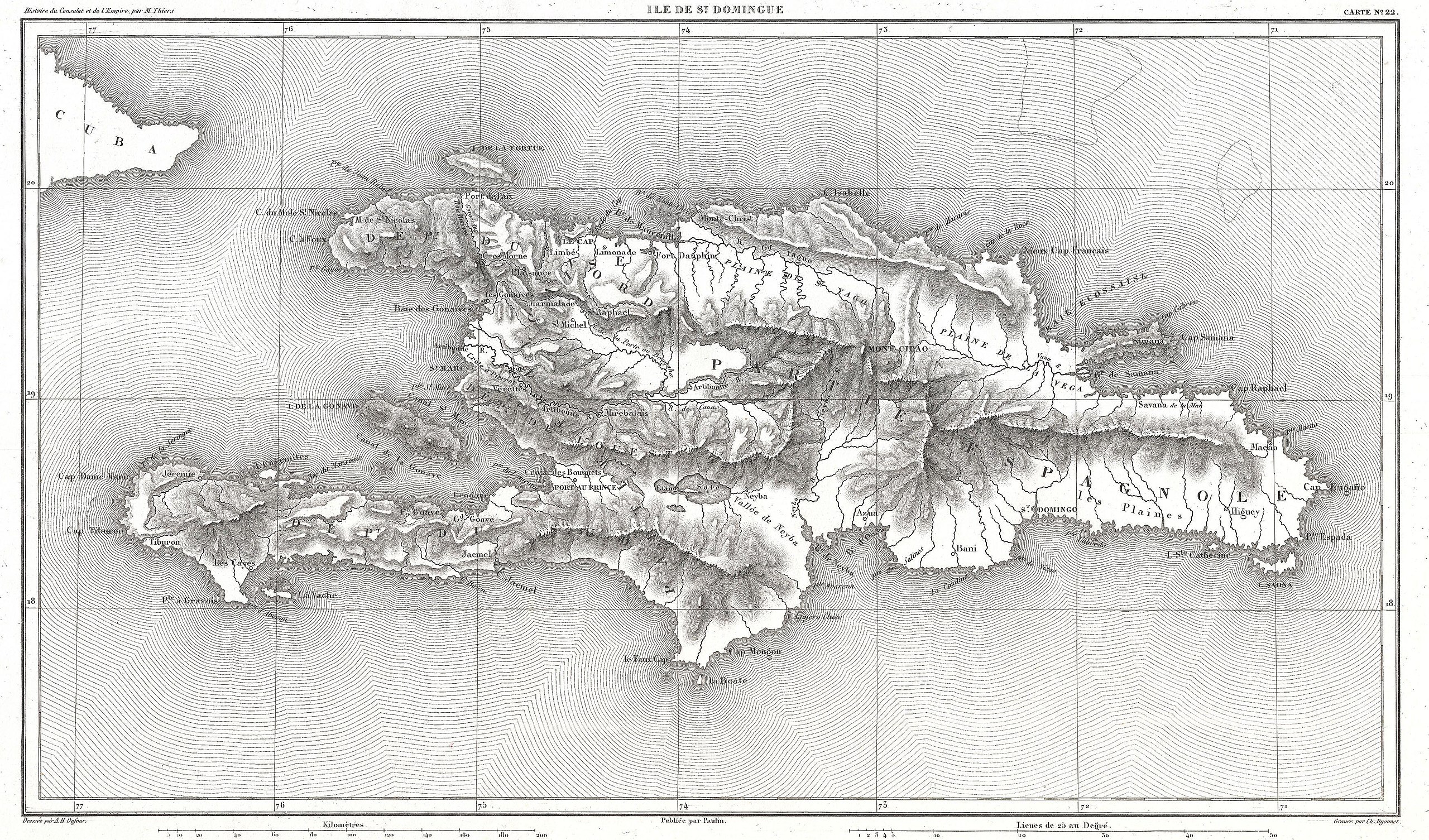
Ile de St. Domingue. |
|||||
| Description |
English: A beautifully engraved map of the West Indies island of Hispaniola or Santo Domingo by the French cartographer August Henri Dufour. Covers the entire island in striking topographical detail. Identifies towns, cities, rivers, lakes, mountains, and various undersea shoals and reefs. Names Mont Cibao, in the central part of the island, where Columbus famously failed to find rich gold mines. Today this island is divided between the Dominican Republic and Haiti. Drawn by A. H. Dufour and engraved by Charles Dyonnet for issue as map no. 22 in M. A. Thiers' History of the Consulate and the Empire of France Under Napoleon , 1859. |
|||||
| Date | 1859 (undated) | |||||
| Dimensions | height: 8.5 in (21.5 cm); width: 14.5 in (36.8 cm) | |||||
| Accession number |
Geographicus link: StDomingue-dufour-1859 |
|||||
| Source/Photographer |
Thiers, M. A., History of the Consulate and the Empire of France Under Napoleon, 1859.
|
|||||
| Permission (Reusing this file) |
|
|||||
File history
Click on a date/time to view the file as it appeared at that time.
| Date/Time | Thumbnail | Dimensions | User | Comment | |
|---|---|---|---|---|---|
| current | 21:32, 23 March 2011 | | 3,500 × 2,058 (2.35 MB) | BotMultichillT | {{subst:User:Multichill/Geographicus |link=http://www.geographicus.com/P/AntiqueMap/StDomingue-dufour-1859 |product_name=1859 Dufour Map of Hispaniola or Santo Domingo, West Indies (Haiti, Dominican Republic) |map_title=Ile de St. Domingue. |description=A |
File usage
The following pages on the English Wikipedia use this file (pages on other projects are not listed):
Global file usage
The following other wikis use this file:
- Usage on es.wikipedia.org
- Usage on nl.wikipedia.org
- Usage on www.wikidata.org
_-_Geographicus_-_StDomingue-dufour-1859.jpg)