File:1818 Pinkerton Map of Northern Africa and the Mediterranean - Geographicus - NorthernAfrica-pinkerton-1818.jpg

Size of this preview: 800 × 584 pixels. Other resolutions: 320 × 234 pixels | 640 × 467 pixels | 1,024 × 747 pixels | 1,280 × 934 pixels | 2,560 × 1,868 pixels | 5,000 × 3,649 pixels.
Original file (5,000 × 3,649 pixels, file size: 4.28 MB, MIME type: image/jpeg)
| This is a file from the Wikimedia Commons. Information from its description page there is shown below. Commons is a freely licensed media file repository. You can help. |
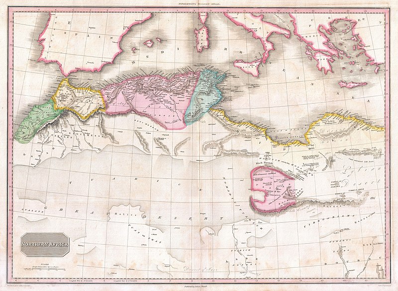
| John Pinkerton: Northern Africa.
( |
|||||||||||||||||||||
|---|---|---|---|---|---|---|---|---|---|---|---|---|---|---|---|---|---|---|---|---|---|
| Artist |
|
||||||||||||||||||||
| Title |
Northern Africa. |
||||||||||||||||||||
| Description |
English: This fascinating hand colored 1818 map by Edinburgh cartographer John Pinkerton depicts northern Africa. Covers from Morocco to Siwa (Siwah) Oasis in the Libyan Desert. Focuses Morocco and the Mediterranean regions of Fez, Algeria, Tunisia and Tripoli. Also shows the Kingdom of Fezzan. Though mostly desert Fezzan has numerous oaises and supported a relatively large population. This desert kingdom was a critical stopping point for trade caravans crossing the Sahara since antiquity. Drawn by L. Herbert and engraved by Samuel Neele under the direction of John Pinkerton. This map comes from the scarce American edition of Pinkerton’s Modern Atlas, published by Thomas Dobson & Co. of Philadelphia in 1818. |
||||||||||||||||||||
| Date | 1818 (undated) | ||||||||||||||||||||
| Dimensions | height: 20.5 in (52 cm); width: 28 in (71.1 cm) | ||||||||||||||||||||
| Accession number |
Geographicus link: NorthernAfrica-pinkerton-1818 |
||||||||||||||||||||
| Source/Photographer |
Pinkerton, J., A Modern Atlas, from the Lates and Best Authorities, Exhibiting the Various Divisions of the World with its chief Empires, Kingdoms, and States; in Sixty Maps, carefully reduced from the Larges and Most Authentic Sources. 1818, Philadelphia, Thomas Dobson Edition.
|
||||||||||||||||||||
| Permission (Reusing this file) |
|
||||||||||||||||||||
| Other versions | |||||||||||||||||||||

_in_1818_Pinkerton_Map_of_Northern_Africa_and_the_Mediterranean_-_Geographicus_-_NorthernAfrica-pinkerton-1818_(cropped).jpg)
File history
Click on a date/time to view the file as it appeared at that time.
| Date/Time | Thumbnail | Dimensions | User | Comment | |
|---|---|---|---|---|---|
| current | 06:33, 23 March 2011 | | 5,000 × 3,649 (4.28 MB) | BotMultichillT | {{subst:User:Multichill/Geographicus |link=http://www.geographicus.com/P/AntiqueMap/NorthernAfrica-pinkerton-1818 |product_name=1818 Pinkerton Map of Northern Africa and the Mediterranean |map_title=Northern Africa. |description=This fascinating hand colo |
File usage
No pages on the English Wikipedia use this file (pages on other projects are not listed).