File:1815 Thomson Map of Porto Rico, Virgin Islands, Haiti, Dominican Republic - Geographicus - PortoRico-t-1815.jpg
Size of this preview: 720 × 600 pixels. Other resolutions: 288 × 240 pixels | 576 × 480 pixels | 922 × 768 pixels | 1,229 × 1,024 pixels | 2,458 × 2,048 pixels | 3,500 × 2,916 pixels.
Original file (3,500 × 2,916 pixels, file size: 2.21 MB, MIME type: image/jpeg)
| This is a file from the Wikimedia Commons. Information from its description page there is shown below. Commons is a freely licensed media file repository. You can help. |
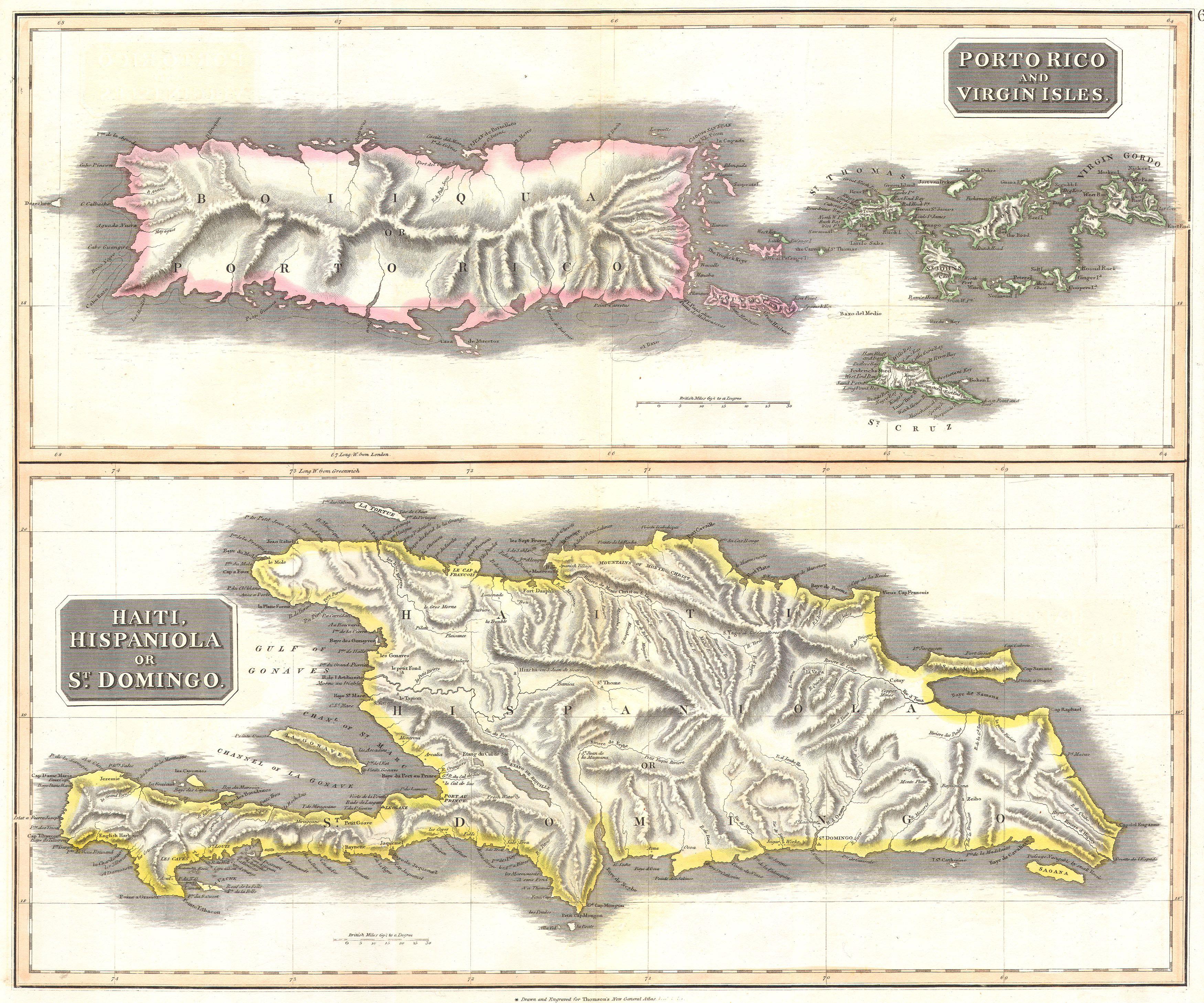
| John Thomson: West India Islands. - Porto Rico and Virgin Isles. - Haiti, Hispaniola or St. Domingo.
( |
||||||||||||||
|---|---|---|---|---|---|---|---|---|---|---|---|---|---|---|
| Artist |
|
|||||||||||||
| Title |
West India Islands. - Porto Rico and Virgin Isles. - Haiti, Hispaniola or St. Domingo. |
|||||||||||||
| Description |
English: This fascinating hand colored 1814 map by Edinburgh cartographer John Thomson depicts the modern West Indies or Caribbean nations of Porto Rico, the Virgin Islands, Haiti, and the Dominican Republic. Divided into two sections, this is a spectacularly detailed map of this regions. Depicts towns and cities, river courses, missions, and topographic details. One of the finest maps of these islands to appear in the 19th century. |
|||||||||||||
| Date | 1815 | |||||||||||||
| Dimensions | height: 20 in (50.8 cm); width: 25 in (63.5 cm) | |||||||||||||
| Accession number |
Geographicus link: PortoRico-t-1815 |
|||||||||||||
| Source/Photographer |
|
|||||||||||||
| Permission (Reusing this file) |
|
|||||||||||||
File history
Click on a date/time to view the file as it appeared at that time.
| Date/Time | Thumbnail | Dimensions | User | Comment | |
|---|---|---|---|---|---|
| current | 11:47, 24 March 2011 | | 3,500 × 2,916 (2.21 MB) | BotMultichillT | {{subst:User:Multichill/Geographicus |link=http://www.geographicus.com/P/AntiqueMap/PortoRico-t-1815 |product_name=1815 Thomson Map of Porto Rico, Virgin Islands, Haiti, Dominican Republic |map_title=West India Islands. - Porto Rico and Virgin Isles. - Ha |
File usage
The following pages on the English Wikipedia use this file (pages on other projects are not listed):