
Size of this preview: 800 × 396 pixels. Other resolutions: 320 × 158 pixels | 640 × 317 pixels | 1,024 × 507 pixels | 1,280 × 634 pixels | 2,560 × 1,268 pixels | 6,045 × 2,993 pixels.
Original file (6,045 × 2,993 pixels, file size: 13.36 MB, MIME type: image/jpeg)
| This is a file from the Wikimedia Commons. Information from its description page there is shown below. Commons is a freely licensed media file repository. You can help. |
Summary
| Description |
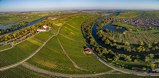
Deutsch: Vogelsburg bei Volkach und Mainschleife aus Richtung Escherndorf |
| Date | |
| Source | Own work |
| Author | BeneFoto |
| Camera location | | View this and other nearby images on: OpenStreetMap |
|---|
Licensing
I, the copyright holder of this work, hereby publish it under the following license:
This file is licensed under the Creative Commons Attribution-Share Alike 4.0 International license.
- You are free:
- to share – to copy, distribute and transmit the work
- to remix – to adapt the work
- Under the following conditions:
- attribution – You must give appropriate credit, provide a link to the license, and indicate if changes were made. You may do so in any reasonable manner, but not in any way that suggests the licensor endorses you or your use.
- share alike – If you remix, transform, or build upon the material, you must distribute your contributions under the same or compatible license as the original.
File history
Click on a date/time to view the file as it appeared at that time.
| Date/Time | Thumbnail | Dimensions | User | Comment | |
|---|---|---|---|---|---|
| current | 16:36, 25 October 2015 | | 6,045 × 2,993 (13.36 MB) | BeneFoto | Version mit höherer Auflösung hochgeladen |
| 16:04, 25 October 2015 |  | 1,920 × 951 (1.86 MB) | BeneFoto | User created page with UploadWizard |
File usage
No pages on the English Wikipedia use this file (pages on other projects are not listed).
Global file usage
The following other wikis use this file:
- Usage on als.wikipedia.org
- Usage on de.wikipedia.org
- Usage on de.wikivoyage.org
- Usage on pl.wikivoyage.org
- Usage on ru.wikipedia.org
- Usage on www.wikidata.org