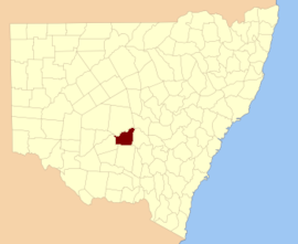
Dowling County is one of the 141 Cadastral divisions of New South Wales.

Dowling
New South Wales
Location in New South Wales
Lands administrative divisions around Dowling:
Blaxland Blaxland Cunningham
Franklin Dowling Gipps
Nicholson Cooper Cooper

Dowling County was named in honour of Judge Sir James Dowling (1787-1844).[1]

Parishes within this county edit

A full list of parishes found within this county; their current LGA and mapping coordinates to the approximate centre of each location is as follows:

Parish LGA Coordinates
Bimbalingel Lachlan Shire Council 33°18′54″S 146°12′04″E / 33.31500°S 146.20111°E / -33.31500; 146.20111 (Bimbalingel)
Bimbil Bland Shire Council 33°37′54″S 146°08′04″E / 33.63167°S 146.13444°E / -33.63167; 146.13444 (Bimbil)
Blairgowrie Bland Shire Council 33°37′54″S 146°35′04″E / 33.63167°S 146.58444°E / -33.63167; 146.58444 (Blairgowrie)
Bootoowa Lachlan Shire Council 33°24′54″S 146°11′04″E / 33.41500°S 146.18444°E / -33.41500; 146.18444 (Bootoowa)
Borapine Lachlan Shire Council 33°18′54″S 146°43′04″E / 33.31500°S 146.71778°E / -33.31500; 146.71778 (Borapine)
Brewer Lachlan Shire Council 33°25′54″S 146°05′04″E / 33.43167°S 146.08444°E / -33.43167; 146.08444 (Brewer)
Brotheroney Lachlan Shire Council 33°10′54″S 146°44′04″E / 33.18167°S 146.73444°E / -33.18167; 146.73444 (Brotheroney)
Cargelligo Lachlan Shire Council 33°22′54″S 146°23′04″E / 33.38167°S 146.38444°E / -33.38167; 146.38444 (Cargelligo)
Carilla Carrathool Shire Council 33°24′54″S 145°55′04″E / 33.41500°S 145.91778°E / -33.41500; 145.91778 (Carilla)
Carisbrook Lachlan Shire Council 33°28′54″S 146°05′04″E / 33.48167°S 146.08444°E / -33.48167; 146.08444 (Carisbrook)
Clowery Bland Shire Council 33°42′54″S 146°40′04″E / 33.71500°S 146.66778°E / -33.71500; 146.66778 (Clowery)
Contarlo Lachlan Shire Council 33°28′54″S 146°10′04″E / 33.48167°S 146.16778°E / -33.48167; 146.16778 (Contarlo)
Currawong Bland Shire Council 33°34′54″S 146°22′04″E / 33.58167°S 146.36778°E / -33.58167; 146.36778 (Currawong)
Curriba Lachlan Shire Council 33°27′54″S 146°41′04″E / 33.46500°S 146.68444°E / -33.46500; 146.68444 (Curriba)
Currikabakh Bland Shire Council 33°43′54″S 146°30′04″E / 33.73167°S 146.50111°E / -33.73167; 146.50111 (Currikabakh)
Davis Bland Shire Council 33°43′54″S 146°07′04″E / 33.73167°S 146.11778°E / -33.73167; 146.11778 (Davis)
Dowling Carrathool Shire Council 33°32′54″S 146°03′04″E / 33.54833°S 146.05111°E / -33.54833; 146.05111 (Dowling)
Gainbill Lachlan Shire Council 33°23′54″S 146°31′04″E / 33.39833°S 146.51778°E / -33.39833; 146.51778 (Gainbill)
Garryowen Lachlan Shire Council 33°28′54″S 146°19′04″E / 33.48167°S 146.31778°E / -33.48167; 146.31778 (Garryowen)
Geelooma Bland Shire Council 33°36′54″S 146°40′04″E / 33.61500°S 146.66778°E / -33.61500; 146.66778 (Geelooma)
Guagong Lachlan Shire Council 33°09′54″S 146°37′04″E / 33.16500°S 146.61778°E / -33.16500; 146.61778 (Guagong)
Gumbagunda Lachlan Shire Council 33°08′54″S 146°29′04″E / 33.14833°S 146.48444°E / -33.14833; 146.48444 (Gumbagunda)
Gurangully Lachlan Shire Council 33°13′54″S 146°24′04″E / 33.23167°S 146.40111°E / -33.23167; 146.40111 (Gurangully)
Jimberoo Bland Shire Council 33°43′54″S 146°13′04″E / 33.73167°S 146.21778°E / -33.73167; 146.21778 (Jimberoo)
Kikoira Bland Shire Council 33°39′54″S 146°40′04″E / 33.66500°S 146.66778°E / -33.66500; 146.66778 (Kikoira)
Killawarra Lachlan Shire Council 33°26′54″S 146°30′04″E / 33.44833°S 146.50111°E / -33.44833; 146.50111 (Killawarra)
Lachlan Lachlan Shire Council 33°11′54″S 146°20′04″E / 33.19833°S 146.33444°E / -33.19833; 146.33444 (Lachlan)
Merri Merrigal Carrathool Shire Council 33°25′54″S 146°00′04″E / 33.43167°S 146.00111°E / -33.43167; 146.00111 (Merri Merrigal)
Mologone Bland Shire Council 33°37′54″S 146°15′04″E / 33.63167°S 146.25111°E / -33.63167; 146.25111 (Mologone)
Moneybung Carrathool Shire Council 33°29′54″S 146°00′04″E / 33.49833°S 146.00111°E / -33.49833; 146.00111 (Moneybung)
Murrabung Bland Shire Council 33°44′54″S 146°24′04″E / 33.74833°S 146.40111°E / -33.74833; 146.40111 (Murrabung)
Naradhan Bland Shire Council 33°43′54″S 146°18′04″E / 33.73167°S 146.30111°E / -33.73167; 146.30111 (Naradhan)
Narden Lachlan Shire Council 33°22′54″S 146°42′04″E / 33.38167°S 146.70111°E / -33.38167; 146.70111 (Narden)
Narriah Bland Shire Council 33°43′54″S 146°34′04″E / 33.73167°S 146.56778°E / -33.73167; 146.56778 (Narriah)
Regent Lachlan Shire Council 33°26′54″S 146°17′04″E / 33.44833°S 146.28444°E / -33.44833; 146.28444 (Regent)
Rutland Bland Shire Council 33°37′54″S 146°31′04″E / 33.63167°S 146.51778°E / -33.63167; 146.51778 (Rutland)
Tibeaudo Lachlan Shire Council 33°24′54″S 146°33′04″E / 33.41500°S 146.55111°E / -33.41500; 146.55111 (Tibeaudo)
Tooronga Lachlan Shire Council 33°22′54″S 146°17′04″E / 33.38167°S 146.28444°E / -33.38167; 146.28444 (Tooronga)
Townsend Carrathool Shire Council 33°33′54″S 145°59′04″E / 33.56500°S 145.98444°E / -33.56500; 145.98444 (Townsend)
Trigalong Lachlan Shire Council 33°11′54″S 146°28′04″E / 33.19833°S 146.46778°E / -33.19833; 146.46778 (Trigalong)
Tuggerabach Lachlan Shire Council 33°28′54″S 146°33′04″E / 33.48167°S 146.55111°E / -33.48167; 146.55111 (Tuggerabach)
Uabba Lachlan Shire Council 33°19′54″S 146°07′04″E / 33.33167°S 146.11778°E / -33.33167; 146.11778 (Uabba)
Ulambong Lachlan Shire Council 33°13′54″S 146°11′04″E / 33.23167°S 146.18444°E / -33.23167; 146.18444 (Ulambong)
Valencia Carrathool Shire Council 33°39′54″S 145°58′04″E / 33.66500°S 145.96778°E / -33.66500; 145.96778 (Valencia)
Wardry Lachlan Shire Council 33°04′54″S 146°45′04″E / 33.08167°S 146.75111°E / -33.08167; 146.75111 (Wardry)
Whoyeo Lachlan Shire Council 33°18′54″S 146°18′04″E / 33.31500°S 146.30111°E / -33.31500; 146.30111 (Whoyeo)
Whyaddra Lachlan Shire Council 33°03′54″S 146°38′04″E / 33.06500°S 146.63444°E / -33.06500; 146.63444 (Whyaddra)
Womboyn Bland Shire Council 33°40′54″S 146°20′04″E / 33.68167°S 146.33444°E / -33.68167; 146.33444 (Womboyn)
Yarrabundry Lachlan Shire Council 33°17′54″S 146°36′04″E / 33.29833°S 146.60111°E / -33.29833; 146.60111 (Yarrabundry)
Yarran Lachlan Shire Council 33°18′54″S 146°31′04″E / 33.31500°S 146.51778°E / -33.31500; 146.51778 (Yarran)
Yelkin Lachlan Shire Council 33°27′54″S 146°22′04″E / 33.46500°S 146.36778°E / -33.46500; 146.36778 (Yelkin)

References edit

  1. ^ "Dowling". Geographical Names Register (GNR) of NSW. Geographical Names Board of New South Wales. Retrieved 4 August 2013.