Cheadle railway station (London and North Western Railway)
Cheadle LNW railway station was a railway station that served Cheadle, Cheshire, England, between 1866 and its closure in 1917.
Construction, location and facilities edit
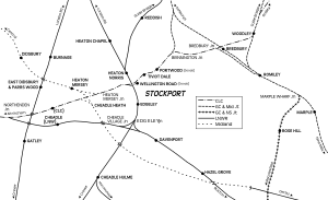
The London and North Western Railway completed its line from Stockport Edgeley to Northenden in 1866. The station was opened on 1 August 1866[1] and was located 100 yards (90 m) north of Cheadle High street at the point where the line (still in use) crossed Manchester Road on an over-bridge. The station was located on the western side of the road and was reached by steps leading up to it.[2] Two platforms were provided. The northern platform handled trains from Warrington to Stockport and the southern side was for trains heading west to Warrington and Liverpool.
Train services and closure edit
On the opening of the line and the station in 1866, the LNWR immediately commenced operating a passenger train service from Manchester London Road via Stockport Edgeley to Cheadle and onwards to Northenden to Broadheath, Warrington Arpley and on to Liverpool Lime Street.
In December 1895, 20 trains per weekday operated from Manchester via Stockport. Seven of these continued on to Broadheath near Altrincham, and two of these continued to Liverpool.[3]
The service was discontinued on 1 January 1917 and the station was closed that day.[1]
LNWR (and from 1923, London Midland and Scottish Railway) goods trains continued to use the line through the station's site from 1917 until 1948. From that date, the trains were operated by British Railways London Midland Region until 21 August 1967, though it was renamed Cheadle South from 1 July 1950.[4]
The line through Cheadle High Level was singled in the early 1970s to facilitate the construction of the M63 motorway (now M60) motorway. From 1992, Mid-Cheshire line passenger trains were diverted to run via Stockport and therefore through Cheadle High Level to allow the direct Altrincham to Manchester route to be transferred to Manchester Metrolink; however, Cheadle High Level station was not reopened.
Proposed new station edit
Following a campaign by local politicians, Cheadle’s Towns Fund Board submitted an application to Stockport Metropolitan Borough Council for a new station for Cheadle on the same site on the Mid-Cheshire line.[5] The station facilities would be built on the car park of the Alexandra Hospital. In 2022 the UK government committed £9million funding to the project and the station is expected to open in 2025. It will have a single 100m long platform providing one train per hour to Stockport/Manchester and to Altrincham/Chester.[6]
| Preceding station | National Rail | Following station | ||
|---|---|---|---|---|
| Future Services | ||||
| Northern Mid-Cheshire Line | ||||
Railway diagram showing Cheadle LNW station and the line to Stockport edit
References edit
- Notes
- ^ a b Butt 1995, p. 58
- ^ Fox 1986, p. 50
- ^ Bradshaw, 1895, p. 345
- ^ Railway Magazine June 1982 p. 293
- ^ Place North West https://www.placenorthwest.co.uk/news/cheadle-station-project-advances/#comments
- ^ "Funding for a new railway station at Cheadle approved". Stockport Metropolitan Borough Council. 8 July 2022. Retrieved 19 July 2022.
- Bibliography
- Bradshaw (2011), Bradshaw's December 1895 Railway Guide (reprint ed.), Middleton Press, ISBN 978-1-908174-11-6
- Butt, R.V.J. (1995), The Directory of Railway Stations, Patrick Stephens Ltd, ISBN 1-85260-508-1
- Fox, Gregory K. (1986), The Railways around Stockport, Foxline Publishing, ISBN 1-870119-00-2
