Banasura Sagar Dam, Situated in Padinjarathara and it is the Largest Earth Dam in India and Second Largest Dam in Asia Banasura Dam is under the control of Padinjarathara KSEB Substation. Dam impounds the Karamanathodu tributary of the Kabini River, is part of the Indian Banasurasagar Project consisting of a dam and a canal project started in 1979.[1] The goal of the project is to support the Kakkayam Hydro electric power project and satisfy the demand for irrigation and drinking water in a region known to have water shortages in seasonal dry periods. The dam is also known as Kuttiyadi Augmentation Main Earthen Dam. The dam has a height of 38.5 metres (126 ft) and length of 685 metres (2,247 ft).
| Banasura Sagar Dam | |
|---|---|
 Banasura Sagar Main Earthfill Dam | |
| Country | India |
| Location | Wayanad, Kerala |
| Coordinates | 11°40′12″N 75°57′28″E / 11.67000°N 75.95778°E |
| Purpose | Multi-purpose |
| Status | Operational |
| Opening date | 2004 |
| Owner(s) | Kerala State Electricity Board |
| Dam and spillways | |
| Impounds | Tributary of the Kabini River |
| Height (foundation) | 38.5 m (126 ft) |
| Length | 685.0 m (2,247 ft) |
| Spillways | Nil |
| Reservoir | |
| Creates | Banasurasagar Reservoir |
| Total capacity | 209,250,000 m3 (169,642 acre⋅ft) |
| Catchment area | 61.44 km2 (24 sq mi) |
| Normal elevation | 775.60 m (2,545 ft) |
| Power Station | |
| Installed capacity | 231.75 MW |


In the dam's reservoir there is a set of islands that were formed when the reservoir submerged the surrounding areas.[2] The islands with the Banasura hills are in the background view.[3] It is the largest earth dam in India and the second largest of its kind in Asia. The dam is made up of massive stacks of stones and boulders.[4]
The Kuttiyadi Augmentation Scheme consists of a main dam known as Banasurasagar Dam, an earth fill dam and a concrete gravity spillway dam and six saddle dams namely, a) Kosani ( Earth fill dam) 13.8 m high b) Near Kottagiri ( Earth fill dam) 11.0 m high c) Kottagiri ( Earth fill dam) 14.5 m high d) Kuttiyadi ( Concrete dam) 16.5 m high e) Nayanmoola ( Earth fill dam) 3.5 m high f) Manjoora ( Earth fill dam) 4.0 m high. All the dams, except Kuttiady saddle, are earth fill dams. The Kuttiyadi saddle dam is a concrete dam. The spillway is located adjacent to the main dam at the right bank of the original river course. The water spread area at FRL / MWL is 12.77 km2. The catchment area of Banasurasagar Dam is 61.44 km2. [5]
Specifications
edit- Location
- Latitude:11⁰40’15”N
- Longitude:75⁰57’21”E
- Panchayath : Padinjarathara
- Village : Padinjarathara
- District : Wayanad
- River Basin : Kabani
- River : Karamanthodu, a tributary of Kabani river
- Release from Dam to river : Karamanthodu
- Taluk through which release flows : Vythiri, Mananthavadi
- Year of completion : 2004
- Name of Project : Kuttiady Augmentation Scheme
- Purposeof Project : Multi purpose
- Type of Dam : Homogeneous rolled earth fill
- Classification : HH ( High Height)
- Maximum Water Level (MWL) : EL 775.60 m
- Full Reservoir Level ( FRL) : EL 775.60 m
- Storage at FRL : 209.25 Mm3
- Height from deepest foundation : 38.5 m ( Height from bed level)
- Length : 685.00 m
- Spillway : No spillway
- Crest Level : NA
- River Outlet : Nil
- Officers in charge & phone No. :
- Executive Engineer, Dam Safety Division No. V, Padinjarathara, PIN- 673122 Phone – 9446008415
- Assistant Executive Engineer, Dam Safety Sub Division, Padinjarathara PIN- 673122 Phone- 9496004480
- Installed capacity of the Project : 231.75 MW
- Project Identification Code ( PIC) : KL29HH0044
Location
editThe Banasura Sagar Dam is located 21 km from Kalpetta, in Wayanad District of Kerala in the Western Ghats. It is the largest earthen dam in India and the second largest in Asia[4] and a starting point for hikes into the surrounding mountains.[6] It is an important tourist attraction.[7] Banasura Sagar Dam is at the foot of the Banasura Hill.
Spillway Dam
edit
Kuttiady Augmentation Spillway dam is a concrete dam with spillways for the Banasurasagar (kutyadi Augmentation) reservoir. The Spillway dam is part of the Kuttiyadi Augmentation Scheme which is located in Wayanad district. It aims at utilizing water of the Karamanthodu River, a tributary of Kabani River. The Scheme consists of a main dam known as Banasurasagar Dam an earth fill dam and a concrete gravity spillway dam and six saddle dams.[citation needed]
Reservoir
edit
The Gross Storage of Kuttiyadi Augmentation (Banasura sagar) Reservoir is 209 Mm3 and live storage 185 Mm3. The water stored in the reservoir is diverted to the reservoir of Kuttiyadi Hydro Electric Project through an interconnecting tunnel. The sill level of diversion tunnel at inlet is 750.83 m. The size and shape of tunnel is varying. It is varying from 2.35 m dia. circular lined tunnel for a length of 890m &2.85 m D-shaped unlined tunnel for a length of 3873 m. Maximum diversion is11.6 m3/s. The diverted water is used for power generation from Kuttiyadi Power Station. FRL of the reservoir is 775.60 m. Top level of dam is 778.50 m. There are four radial gates, each of size 10.97 m x 9.20 m. Crest level of spillway is 767.00 m. Spillway capacity is 1664 m3/s. One lower level outlet is provided in the spillway structure at750.75 m of size 1.10 m X 1.75 m to release irrigation requirement.[citation needed]
Etymology
editThe Banasura Sagar Dam is named after Banasura, the son of Mahabali who as per local Hindu mythological belief was a very respected king of Kerala.[citation needed]
Tourism
editThe dam has become a popular tourist destination. Many people visit the place to go trekking at the Banasura Hill & speed boating at Banasura Sagar Dam. The Banasura Hill Resort, located about 20 km from the dam was rated as Asia's largest Earthen Resort by BBC. Speed & pedal boats are available & are major hits with tourists. Speed boat ride, in particular, is an exhilarating experience & not to be missed.[citation needed]
Gallery
edit-
 The view of reservoir from nearby mountains
 -
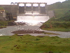 Banasura sagar spill way dam which is adjacent to the Main earthfill dam
 -
 Male orange minivet at Banasura Dam
 -
 A view from Banasura Dam
 -
 Boating facility

.jpg)
_at_Banasura_Dam.JPG)


Current Scenario
editThe actual missions for this dam is to provide water for Kakkayam reservoir[8] which is situated in Kozhikode district to produce electricity and also irrigation in Wayanad, both the missions were not accomplished and currently it is a part of the Hydel project. It has India's first Solar Atop Dam.[9]
See also
editReferences
edit- ^ "Government of Kerala Tenth Five Year Plan 2002-07 Report" (PDF). Government of Kerala. Archived from the original (PDF) on 18 December 2005. Retrieved 18 October 2006.
- ^ "Wayanad outdoor trails". wayanad.org. Archived from the original on 23 October 2006. Retrieved 14 October 2006.
- ^ "Wayanad". Fast Finder Kerala. Archived from the original on 29 September 2007. Retrieved 14 October 2006.
- ^ a b "Banasura Sagar Dam". Retrieved 11 February 2013.
- ^ "Banasurasagar Dam – KSEB Limited Dam Safety Organisation". Retrieved 30 July 2021.
 This article incorporates text available under the CC BY-SA 2.5 license.
- ^ "Statistical Data". Kerala Government. Archived from the original on 28 May 2006. Retrieved 14 October 2006.
- ^ "Places of Tourist Importance". Wayanad Government. Archived from the original on 5 May 2006. Retrieved 14 October 2006.
- ^ "Kakkayam Dam Reservoir - Wikimapia". wikimapia.org. Retrieved 16 December 2015.
- ^ "Kerala: Solar panel atop dam a reality". 30 April 2016.