Talk:History of Transylvania
| This is the talk page for discussing improvements to the History of Transylvania article. This is not a forum for general discussion of the article's subject. |
Article policies
|
| Find sources: Google (books · news · scholar · free images · WP refs) · FENS · JSTOR · TWL |
| Archives: 1, 2, 3, 4Auto-archiving period: 365 days |
| This It is of interest to multiple WikiProjects. | |||||||||||||||||||||||||||||||||||||||||||||||||||||||||||||||||||||||||||||||||||||||||||||||||||||||||||||||||||||||||
| |||||||||||||||||||||||||||||||||||||||||||||||||||||||||||||||||||||||||||||||||||||||||||||||||||||||||||||||||||||||||


.svg)


Trajan's Column correct picture edit
Hi Aristeus01, can we settle the disagreement here about whether or not people can recognize what is happening on the full and unedited Trajan's Column, and that is it better than the previous image ([1])? I don't understand the logic in your revert reason ([2]), but we can make that happen by summoning an RfC, if you consent. What do you think? Gyalu22 (talk) 06:46, 28 August 2023 (UTC)
- hi @Gyalu22! Sounds like a good idea. Aristeus01 (talk) 06:55, 28 August 2023 (UTC)
- Yes, what do RS say, issue solved. Slatersteven (talk) 09:53, 29 August 2023 (UTC)
RfC edit
Can readers recognize what is happening on the illustrations of the full and unedited picture of Trajan's Column or should we break it up to edited version(s)? See the chapter § Ancient history. Gyalu22 (talk) 10:51, 28 August 2023 (UTC)
- Procedural close. I do not see that the editors who disagree on this have made any effort to discuss and resolve this matter before starting an RfC, and that is required. Talk about it first, see if you can come to an agreement, and if you hit an impasse, then an RfC might be appropriate. Seraphimblade Talk to me 13:09, 28 August 2023 (UTC)
- I can't identify what the column shows from the current picture and I think other readers can't too. Aristeus01 believes the opposite. Can you give any advice on how the two of us can decide which possibility is better for readers? Gyalu22 (talk) 14:48, 28 August 2023 (UTC)
- @Seraphimblade thank you for joining.
- I confirm that what gyalu22 said is the root if the discussion. So we can kick-start a discussion: from my view the image offers more detail than a simple frame from the monument and I think that is more informative for the reader. It can also be zoomed in on the PC version. We are very fortunate to have such detailed images available and it would be a shame to not use them. Aristeus01 (talk) 15:08, 28 August 2023 (UTC)
- Alright, see, there we go. Now we know what everyone's position is, and why. So talk about it, and see if you can come to an agreement. (Is there, by the way, any reason that both images couldn't be used in the article? That should seem to me the simplest solution.) Seraphimblade Talk to me 17:23, 28 August 2023 (UTC)
- The resolution of the image is indeed very good, but my point is rather at the reader's ability to infer what is happening. The Column's informative value shouldn't be forgotten. We can make use of that if we divide it up and provide the frames with explanatory captions. Otherwise, it's nice, but its stories remain esoteric and it can't illustrate the events that well. Gyalu22 (talk) 19:24, 28 August 2023 (UTC)
- I am a picture fan, I usually put many images to articles (maybe sometimes too much), so for me would be ok to keep both. That depiction is related to the ancient history of Transylvania. OrionNimrod (talk) 19:54, 28 August 2023 (UTC)
- Or we can combine both: realistic photo and detailed, examples:
- https://commons.wikimedia.org/wiki/File:Colonna_di_Traiano,_particolare_(27660411886).jpg
- https://commons.wikimedia.org/wiki/File:IT_Roma_1106_(42)_(17069153470).jpg
- https://commons.wikimedia.org/wiki/File:Colonna_di_Traiano,_particolare_(27620575891).jpg
- https://commons.wikimedia.org/wiki/File:Colonna_di_Traiano,_particolare_(27416680210).jpg OrionNimrod (talk) 19:58, 28 August 2023 (UTC)
- Those are some great images, @OrionNimrod, thank you! I would not mind using a couple of them. Aristeus01 (talk) 20:10, 28 August 2023 (UTC)
- @OrionNimrod Yes, I was referring to similar pictures.
- @Aristeus01 Here are the scenes with descriptions if you click the icon at the bottom: http://www.trajans-column.org/?page_id=107 http://www.trajans-column.org/?page_id=578 Gyalu22 (talk) 05:02, 29 August 2023 (UTC)
- Aristeus01 so how did you decide? Do you agree that we change back to the previous picture and use separate pictures and captions when we want to give an illustration to an event from the wars? Gyalu22 (talk) 06:11, 30 August 2023 (UTC)
- @Gyalu22 no. The column itself is important. We can perhaps replace it and the denarii with a closer image like the first OrionNimrod proposed, but individual separate frames won't do it justice. Aristeus01 (talk) 07:30, 30 August 2023 (UTC)
- Why? Gyalu22 (talk) 08:05, 30 August 2023 (UTC)
- Because the monument itself, not a specific scene from it, is the most quoted example of recorded history of the Dacian Wars in historical studies. Aristeus01 (talk) 12:10, 30 August 2023 (UTC)
- To put in the whole monument is not a quotation because no one will be able to understand what the scenes say. If we insert them separately, then they will have a meaning. Gyalu22 (talk) 16:05, 30 August 2023 (UTC)
- That is just your opinion, your preference. Again, the sources speak of the entire monument, not just a single frame.
- Going on the thread of smaller images, here is another example:
- File:IT Roma 1106 (53) (16636497943).jpg - Wikimedia Commons but the quality is not as good as in the current image. Aristeus01 (talk) 18:33, 30 August 2023 (UTC)
- I have no problem to show the big column as mark of the Dacian Roman wars, but it would be good to show some detailed images with description of the current scene. OrionNimrod (talk) 19:24, 30 August 2023 (UTC)
- @OrionNimrod that could work. Perhaps one instead the denarius image? Aristeus01 (talk) 21:58, 30 August 2023 (UTC)
- In my opinion, the coin is pretty cool. And it represents the provincial era, while column is more about war times. I think there's enough space in § Roman-Dacian Wars to put back at least the image of the Dacian population. Gyalu22 (talk) 06:31, 31 August 2023 (UTC)
- Ok, I'm fine with that. Aristeus01 (talk) 06:50, 31 August 2023 (UTC)
- I think the column and its reliefs a great piece of art, it would be good to show a close up photo with description. OrionNimrod (talk) 08:06, 31 August 2023 (UTC)
- Ok, I'm fine with that. Aristeus01 (talk) 06:50, 31 August 2023 (UTC)
- In my opinion, the coin is pretty cool. And it represents the provincial era, while column is more about war times. I think there's enough space in § Roman-Dacian Wars to put back at least the image of the Dacian population. Gyalu22 (talk) 06:31, 31 August 2023 (UTC)
- @OrionNimrod that could work. Perhaps one instead the denarius image? Aristeus01 (talk) 21:58, 30 August 2023 (UTC)
- I have no problem to show the big column as mark of the Dacian Roman wars, but it would be good to show some detailed images with description of the current scene. OrionNimrod (talk) 19:24, 30 August 2023 (UTC)
- To put in the whole monument is not a quotation because no one will be able to understand what the scenes say. If we insert them separately, then they will have a meaning. Gyalu22 (talk) 16:05, 30 August 2023 (UTC)
- Because the monument itself, not a specific scene from it, is the most quoted example of recorded history of the Dacian Wars in historical studies. Aristeus01 (talk) 12:10, 30 August 2023 (UTC)
- Why? Gyalu22 (talk) 08:05, 30 August 2023 (UTC)
- @Gyalu22 no. The column itself is important. We can perhaps replace it and the denarii with a closer image like the first OrionNimrod proposed, but individual separate frames won't do it justice. Aristeus01 (talk) 07:30, 30 August 2023 (UTC)
- Aristeus01 so how did you decide? Do you agree that we change back to the previous picture and use separate pictures and captions when we want to give an illustration to an event from the wars? Gyalu22 (talk) 06:11, 30 August 2023 (UTC)
- I am a picture fan, I usually put many images to articles (maybe sometimes too much), so for me would be ok to keep both. That depiction is related to the ancient history of Transylvania. OrionNimrod (talk) 19:54, 28 August 2023 (UTC)
Undefined ref edit
@Netpartizán: please fill in a source for the ref that you named "kypos". -- Fyrael (talk) 15:19, 4 October 2023 (UTC)
Content edit
Hi Aristeus01
I removed this unrelated content from the Hungarian conquest chapter [3]
But could you explain what is this? Why did you readded? I really do not understand. I suppose the" history of Transylvania" article is about the key history events not a deailed archeology book. Why should we list "Blandina A, B, C, D, E, F..." "Pemilor X2, X3, X5..." archeolgy sites? Are these info important regarding the historical events in Transylvania? Why should we only emphasize 4 sites 400 years long between 800-1200? Should I add more hundred additonal sites in the list? Should we list every single Dacian, Roman, Gepid, Goth, Avar, Hungarian... cemetery? Should we list every single pottery and findings on those sites? It would easier just put a image where the archeology sites are marked as dots. Did you see in other Wiki articles to list archeology sites one by one? I did not see ever. Or it should be a separate article "archeology sites in Transylvania". What is the connection listing site with the Christianity chapter? The chapter clearly say it was Christianity in Transylvania in the period of 9-13th century. What is the connection with the "the culture of the Transylvanian highland" in 1000m with the Christianity? Too much "possible", instead of real key events? Btw we know well Transylvania was never empty, locals did not evaporated, just mixed always with newcomers. OrionNimrod (talk) 12:03, 29 February 2024 (UTC)
- Hi @OrionNimrod
- Yes, of course we should add more information pertaining to Archaeology branch of history and you are most welcomed, at least from my point of view, to do so. After all, the page is called History of Transylvania. As for how much in detail we should go, we can always discuss on concrete cases. The addition of this type of data is already accepted in the article:
- "The earliest Hungarian artifacts found in Transylvania date to the first half of the 10th century. The very typical feature of the Asian Hun and European Hun cemeteries is the partial horse burials, almost in all Hun graves there are only remain of horses. Outside the Huns, only the Hungarians used partial horse burials. This ancient tradition that went through centuries, it is easily identifiable in the Huns and Hungarians graves. Archeologists also found this kind of horse burial in Transylvania. During joint research, archaeologists from the University of Sibiu (Romania) and the University of Tübingen (Germany) excavated one of the most important Hungarian cemeteries from the time of the Hungarian conquest near Orăștie (Szászváros in Hungarian) in 2005. According to Romanian archeologist Marian Tiplic, the excavated graves refer to the second generation of Hungarian conquerors, the skeletons found here are the remains of the Gyula tribe. It was a permanent settlement, the location of which, on top of a hill, suggests that the goal of the Hungarian was to control the valley of the Mureș. Hungarian cemeteries from the 9th and 10th centuries were also unearthed at Cluj-Napoca (Kolozsvár in Hungarian), Gâmbaș (Marosgombás in Hungarian), and other Transylvanian sites. A coin minted under Berthold, Duke of Bavaria (reign 938–947) found near Turda indicates that Transylvanian Magyars participated in western military campaigns. Although their defeat in the 955 Battle of Lechfeld ended Magyar raids against western Europe, raids on the Balkan Peninsula continued until 970. Linguistic evidence suggests that after their conquest, the Magyars inherited the local social structures of the conquered Pannonian Slavs; in Transylvania, there was intermarriage between the Magyar ruling class and the Slavic élite."
- so I do not understand why the discussed information should be treated differently. Aristeus01 (talk) 16:07, 29 February 2024 (UTC)
- Hi, Aristeus01 Those Hungarian content are sentences (btw those were there a long time ago before my first edit) not a list with arcehological codenames and "possible influence" speculation. It is quite out of the style https://en.wikipedia.org/wiki/Wikipedia:Writing_better_articles#Information_style_and_tone. I checked the source, somewhere it use "?" "Ciumbrud (south Danubian influence Christian?)", it is important to list speculations with "?" ? Do we have space for those things in a long wiki history page? The Hungarian related content shows an uique type of burial and the time of the apperance of the first conqueros there, tribe names, settlements, related history story. Morover the deleted list shows only 4 sites in a wide timeline between 9-12th century, it does not clear the exact period of each, while the Hungarian story match to the content, focusing to the conquest period. Btw how fit that list to the Christianity chapter? What about the "possible" highlanders 1000m? Along these groups, Gh Baltag introduced the concept of Table land culture that defines a local population of the 8th to 10th centuries, living on the high altitude areas (600-800m). His argument is represented by the unusual ceramic discovered on the site of Albeşti, Mureş County. Speculation based on 1 ceramic item? Is this a Christianity history event? Is this really important in a such a long article with many important history events? OrionNimrod (talk) 16:59, 29 February 2024 (UTC)
- @OrionNimrod
- Certainly that taken out of context, the rescued text might appear questionable. I would kindly remind you that it was added there as a continuation of the paragraph:
- "According to supporters of the Daco-Roman continuity theory, Transylvania was populated by Romanians at the time of the Hungarian conquest. Opponents of this theory assert that Transylvania was sparsely inhabited by peoples of Slavic origin and Turkic people. The presence of Slavs is confirmed by archaeology, but no distinctive trace of Romanians had been found in Transylvania at the time of the Hungarian conquest."
- With or without the logical connection or the overall debate, I do think it is important to have these scientific results in the article. I am still quite perplexed on why we did not add them previously, considering the claim of knowledge on the topic. I mean, actual, physical evidence from a period of 3-400 years from the history of the area when we have little written evidence must at least be mentioned.
- If the issue is the connection of the text with the rest of the paragraph, I propose the following: moving the " funerary rite and rituals" at the beginning of the sentence, since this is a religious-connected practice:
- "Based on the funerary rite and rituals, Transylvania was multi-ethnic in the period of 9th to 12th centuries, being inhabited by several cultural groups according to Romanian-German archaeologist Kurt Horedt:
- (list)
- "and removing the paragraph:
- "In addition, Romanian archeologist Gheorghe Baltag, based on his research at Albești site, Mureș County, defined "the culture of the Transylvanian highland", referring to a possible indigenous culture in higher areas (over 600m and up to 900-1000m) between 8th and 10th centuries."
- which to me is just a speculation (but again, I am obviously not an expert on Transylvanian archaeology). Aristeus01 (talk) 17:37, 29 February 2024 (UTC)
- Hi Aristeus01, btw I read the full chapter [4] the deleted content is from the very end in the source. And the majority of archeology part in the very detailed sections talk about mostly the Hungarian remains (and before Avars, Slavs), but somehow the summarize at the end just mention Kurdt Horedt from 1950s which was used here.
- So I see, you like that source, becuuse mentions "Romanians" based by speculation. In this case I think, this could be add to the demographic section. I also find interesting things in the source regarding archeology:
- The history of the Romanian territories between the end of the 9th century to the beginning of the 12th is still a debated subject. Due to the lack of archaeological data that could prove the existence of the Romanian population in Transylvania, starting with the 19th century, the Romanian historiography transformed the stages of the formation of Romanian people into a political issue related to that time’s status-quo. The archaeological researches of the early medieval period of the Transylvanian territories are a necessity since the historiography has little resources to call on the written evidences of the events of 9th to 12th centuries. Identifying archaeological artefacts belonging to the Hungarian population within the Carpathian Basin is only a routine exercise for today’s archeologists.Warrior inhumations, particularities of their outfit and weaponry were related to the Hungarian Conquest Period since, in 1834, when western coins dated the 10th century were first found. On the next decays, Romanian Ethno genesis as well as the formation of the Romanian Medieval states captured the interests of scholars. Not always those informations were also pertinent, so as a consequence various critical analysis were elaborated. One of these critical reviews materialized in 1990 on an article by Radu Popa256 Given the circumstances of the medieval archaeology, regarded as a branch of the Romanian historical researches, it is not a surprise that a big part of the results are corrupted and unreal. The new wave of young archaeologists which emerged after 1990 has a difficult task: to get rid of the lumber from previous archaeological researches , the one who, in the early ‘90s established a new direction on the medieval Romanian archaeological researches. He is the one that critically analyzed all the thesis of the Romanian historiography related to the emergence of Romanian states and their relations to the Arpadian royalty and the Transylvanian population.
- I also find similar by other Romanian authors:
- Andrei Gandila: Cultural Encounters on Byzantium’s Northern Frontier, c. AD 500-700 Coins, Artifacts and History, Cambridge 2018
- "Although to some extent the manipulation of archaeological material was true of most Eastern European schools between 1945 and 1989, the Romanian case became the most conspicuous in its attempt to distort the past in order to serve the communist regime’s quest for legitimacy in the 1970s and 1980s."
- "The nationalistic discourse dominating the last communist decades in Eastern Europe distorted not only the interpretation of the archaeological evidence discussed in the previous chapter, but also views on the development of Christianity. Most studies shared a common agenda: to demonstrate the cultural continuity of the Daco-Roman population across centuries of vicissitude when the descendants of the Roman colonists had to deal with numerous barbarian invasions, while struggling to maintain their connection to the Roman world and assimilate the newcomers into their superior culture."
- "Such theories developed in the 1970s and 1980s in the context of national-communism remain firmly entrenched in historiography to this day."
- Florin Curta [5] “A leading Romanian medievalist, Radu Popa in a devastating critique published first in Romanian, then in German, Popa accused Romanian archaeologists of having paid lip service to Ceaucescu’s regime and of having manipulated the archaeological evidence to meet the demands of his nationalist policies in Transylvania. One of Popa’s targets was the group of archaeologists excavating the early medieval hillfort at Dabaca, near Cluj-Napoca. During the late 1960s through 1989, the site was repeatedly identified with the capital city of Gelou, a Romanian duke mentioned in Gesta Hungarorum as having opposed the conquest of Transylvania by Tuhutum. Romanian archaeologists made every possible effort to turn Dabaca into a Transylvanian Troy and to prove that the Gesta was a reliable source for the medieval history of (Romanian) Transylvania. Popa criticized not only this historicist stance, but also the manipulation of the archaeological evidence in order to match the historical record. Moreover, despite extensive excavations designed to produce substantial evidence of a Romanian occupation of the site prior to the Magyar conquest, to this day no results have been published.” OrionNimrod (talk) 17:58, 29 February 2024 (UTC)
- Hi @OrionNimrod
- I'm not going to lie, I am slightly disappointed that we resort to the same antiques of "you like" and "theories developed in the 1970s and 1980s". It is 2024 after all, although some act like its the 1930s, and, regardless of editor, sources created by Romanians cannot be excluded from the history of an area... in Romania.
- But if we are to be objective and follow Curta's thinking the we should also take this into account:
- "Bona's perversely Kossinist approach has its roots in a long tradition established by the "Budapest school" of archaeology. His obstinate focus on ethnic interpretation and political interpretation did not go unnoticed and were promptly denounced."
- so the following parts of the article should also come under question:
- "By 376 a new wave of migratory people, the Huns, led by Uldin defeated and expelled the Visigoths, setting up their own headquarters in what was Dacia Inferior. Hoping to find refuge from the Huns, Fritigern (a Visigothic leader) appealed to the Roman emperor Valens in 376 to be allowed to settle with his people on the south bank of the Danube. However, a famine broke out and Rome was unable to supply them with food or land. As a result, the Goths rebelled against the Romans for several years. The Huns fought the Alans, Vandals, and Quadi, forcing them toward the Roman Empire. Pannonia became the centre during the peak of Attila's reign (435–453).
The race of Huns, long shut off by inaccessible mountains, broke out in sudden rage against the Goths and drove them in widespread confusion from their old homes. The Goths fled across the Danube and were received by Valens without negotiating any treaty.- Paulus Orosius: Histories against the Pagans
- Dating from 425 to 455, the Transylvanian traces of the Huns lie in the lowlands of the Mureș valley. The most important testimonies of the Hun rule are the two separate sets of coins discovered at Sebeș. Between the 420s and 455, Hun princes and lords established summer residences in Transylvania. The newest discoveries strengthens the theory that there was a more serious Hun military presence in Transylvania."
- and
- "The earliest Hungarian artifacts found in Transylvania date to the first half of the 10th century. The very typical feature of the Asian Hun and European Hun cemeteries is the partial horse burials, almost in all Hun graves there are only remain of horses. Outside the Huns, only the Hungarians used partial horse burials. This ancient tradition that went through centuries, it is easily identifiable in the Huns and Hungarians graves. Archeologists also found this kind of horse burial in Transylvania. During joint research, archaeologists from the University of Sibiu (Romania) and the University of Tübingen (Germany) excavated one of the most important Hungarian cemeteries from the time of the Hungarian conquest near Orăștie (Szászváros in Hungarian) in 2005. According to Romanian archeologist Marian Tiplic, the excavated graves refer to the second generation of Hungarian conquerors, the skeletons found here are the remains of the Gyula tribe. It was a permanent settlement, the location of which, on top of a hill, suggests that the goal of the Hungarian was to control the valley of the Mureș. Hungarian cemeteries from the 9th and 10th centuries were also unearthed at Cluj-Napoca (Kolozsvár in Hungarian), Gâmbaș (Marosgombás in Hungarian), and other Transylvanian sites. A coin minted under Berthold, Duke of Bavaria (reign 938–947) found near Turda indicates that Transylvanian Magyars participated in western military campaigns. Although their defeat in the 955 Battle of Lechfeld ended Magyar raids against western Europe, raids on the Balkan Peninsula continued until 970. Linguistic evidence suggests that after their conquest, the Magyars inherited the local social structures of the conquered Pannonian Slavs; in Transylvania, there was intermarriage between the Magyar ruling class and the Slavic élite."
- for example, pardon my repetition.
- But our disagreement is not on some 1990 theories, it is, from my point of view, on the relevance of the data in the rescued text. And to complement the sources you mentioned and strengthen the importance of those archaeological finds here are a few more:
- "When do similar assemblages with handmade pottery appear inside the Carpathian Arc? It is not easy to answer that question, primarily because handmade pottery (including shapes that are directly comparable to the so-called Prague type)are known from assemblages that can be dated to the 6th century and have been attributed to the Gepids. For example, at Rákoczifalva (near Szolnok, on the Middle Tisza river), handmade pottery appears together with wheel-made potterywith burnished or stamped decoration. Handmade pottery appears together with wheel-made pottery with burnished or stamped decoration in three assemblages of the 6th-century settlement excavated in Moreşti, near Târgu Mureş, in the heart of Transylvania."
- An ironic smile: the Carpathian Mountains and the migration of the Slavs - Florin Curta
- "Transylvania entered the Hungarians’ sphere of interest from the beginning, but the actual situation of the region before the conquest is difficult to reconstruct due to the extremely poor written sources and a rather rudimentary archaeological knowledge. Although there has been some progress over the past century, no one has yet outlined a credible picture of what Transylvania might have looked like around the year 1000, a picture that could be equally accepted by any historiographical approach.
- The archaeological remains show that Transylvania was inhabited by a heterogeneous population"
- Church Archaeology in Transylvania (ca. 950 to ca. 1450) - Daniela Marcu-Istrate
- "Transylvanian archaeology as such at present is experiencing a revival as well. The heritage and the school of Béla Pósta were newly established in Cluj by the Béla Pósta Association and the Transylvanian Museum Society, who for many years has been organizing annual archaeological conferences and also created a by now well-established archaeological school for Hungarian students focusing mostly on local sites. Important schools and excavations were organized emphasizing the medieval history of Transylvania and establishing a first generation of medieval archaeologists in the region."
- Archaeology in Transylvania - Csaba Szabó
- As for the locations themselves:
- Necropola medieval timpurie de la Alba Iulia-Str. Brânduşei. Cercetările arheologice din anii 1997-2008
- The early medieval necropolis from Alba Iulia - Izvorul Împăratului. Archaeological researches in 2014
- Byzantine influences in the Carpathian Basin around the turn of the millennium. The pillared church of Alba Iulia
- The Military Suite from Alba Iulia-Emperor’s Spring’s Necropolis
- So we have numerous sources dealing with the content we discuss. And just like in the case of questioning the relevance of early Christianity in Transylvania, I just do not understand why we side-line the topic. Unless, of course, as Curta said, we mean to follow an "obstinate focus on ethnic interpretation and political interpretation", presenting only information that can be associate with an ethnicity or the other. Aristeus01 (talk) 19:51, 29 February 2024 (UTC)
- Hi Aristeus01. The text recently added by this Romanian user is clearly intended to create bias. It is actually a mention of irrelevant opinions from certain Romanian archaeologists. The insertion of a list of random archaeological sites there is also abnormal and inapposite. The whole addition diverges from the style of the article and summary style the article has to take. And probably no one will agree with your solution to also oppositely expand Hungarian views. We should return to the non-speculative and non-theorizing, instead factual-in-nature explanation of the two standpoints and the telling of established history. You can get rid of this if you can argue what's wrong with it. Gyalu22 (talk) 13:45, 2 March 2024 (UTC)
- Hi @Gyalu22
- "The text recently added by this Romanian user is clearly intended to create bias"
- the bias was already created by claiming in Wikivoice the following:
- " The presence of Slavs is confirmed by archaeology, but no distinctive trace of Romanians had been found in Transylvania at the time of the Hungarian conquest."
- the user was correct in correcting that statement to achieve neutrality.
- And speaking of bias, twice in your reply you dismiss opinions as "biased" and "irrelevant" because they are Romanian, hence your further claim of "factual-in-nature explanation of the two standpoints and the telling of established history" drops in objective value. Aristeus01 (talk) 14:07, 2 March 2024 (UTC)
- I also dismiss writing down Hungarian opinions (while you embraced the idea of expanding further this way) because they aren't appropriate here. Again, why should we drop the required summary style to explain theories of random scholars? To my understanding, it's correct that no definite evidence of Romanian presence in Transylvania during that time is known, and this is why concurrent standpoints have emerged. Certain scholars may consider certain things to be such (and develop their own hypotheses of them), but that's no cause to start describing each of their researches.
- The concurrent standpoints are introduced briefly, and elsewhere the article unfolds its topic regional history (not so much archaeology, especially not so much to discuss specific sites BTW) using data everyone agrees upon. This is in accordance with the editing guidelines, while the novel text isn't. Gyalu22 (talk) 15:05, 2 March 2024 (UTC)
- Precisely, and we should keep these concurrent standpoints to a briefness that does not trigger users to expand with counter-arguments in one direction or another. So from my point of view neither
- " but no distinctive trace of Romanians had been found in Transylvania at the time of the Hungarian conquest."
- and
- "Romanian archeologist Marian Tiplic considers that the graves dated in the end of the 9th century and beginning of 10th century, that belong to the Blandiana A and the Ciumbrud cultural groups, represent the last stage in the Romanian people ethnogenesis.
- In addition, Romanian archeologist Gheorghe Baltag, based on his research at Albești site, Mureș County, defined "the culture of the Transylvanian highland", referring to a possible indigenous culture in higher areas (over 600m and up to 900-1000m) between 8th and 10th centuries."
- are needed, since we already said and established that:
- "Conflicting theories exist concerning whether or not the Romanians are a Romanized Dacian population that, surviving the Migration Period remained in Transylvania after the withdrawal of the Romans."
- and this should be enough. Whoever wants to know more can check the linked article which far better explains the situation than a few contradicting paragraphs on this page.
- For my interest the only part needed from the rescued text is the Kurt Horedt research which is on funerary rites and rituals and strongly connected to the history of Christianity in the area. That we express it as a list or a contiguous text is a matter of style and I do not object either way. But I am not willing to part with the rest of text just because @OrionNimrod wanted it deleted. The article must be written from a neutral point of view. Aristeus01 (talk) 15:26, 2 March 2024 (UTC)
- My problem was the style and relevance. I have no problem to present more scholar viewpoints. I think what Tiplic says (“we beleive”) should be fit to the demography research section. OrionNimrod (talk) 23:29, 2 March 2024 (UTC)
- So far we've determined that the recently added text is not good in the article. But can we not remove irrelevant speculations in exchange for suitable factual information that is written in accordance to the encyclopedia instructions? That wouldn't be an improvement. Please see the lead of Origin of the Romanians, which also doesn't omit saying the conclusion that no definite evidence exists (and this is the reason that large opposing scholarly theories emerged).
- Again, I don't uphold getting rid of appropriate information (whose correctness nor relevance is doubtful), but I'm happy we've reached the starting point that attempting to decrease its weight with subjective archaeology lessons is inappropriate. Gyalu22 (talk) 14:23, 3 March 2024 (UTC)
- Sorry, I haven't noticed you want to keep Horedt's theory. To that, the same applies as to the other theories. Gyalu22 (talk) 14:27, 3 March 2024 (UTC)
- Sorry, but I do not see where we determined that the added text is irrelevant speculation and no good for the article. I'm no expert on archaeology, but looking at the sources, and in particular at Curta's study linked a bit earlier, I am not convinced we established facts, not from an archaeological point of view, and what you call subjective archaeology expands to more than one entry.
- "The presence of Slavs is confirmed by archaeology, but no distinctive trace of Romanians had been found in Transylvania at the time of the Hungarian conquest."
- Is not a factual information. Who established this? The sources do not seem as authoritative as one would expect, it is a line cited from a single author. But as a scholarly opinion I understand if you want it kept in the text, or even expanded - as I understand @OrionNimrod leans towards. However, then the same would apply to the other ones. I mean, it's basic logic that expanding means adding more, hence the rescued text should stay and we should add more in the same vein. That is exactly the same principle the article on the Origin of Romanians works.
- For the opposite option, towards which you and I seem more favorable, I need to make a clarification, and perhaps I wasn't explicit enough previously: the archaeological sites presented by Horedt and by extension the objects within are real, non-subject to interpretation. So when we say factual, it cannot get more factual than that. Why would we remove facts from the article? And why not remove the duplicate regarding the theories on Origin of Romanians? Aristeus01 (talk) 15:45, 3 March 2024 (UTC)
- If that's not a problem for you, let's get to a point on this first and discuss Horedt separately.
- If you hold onto these two lines (Tiplic and Balthag) to balance in your opinion bias created by that other sentence elsewhere, but you otherwise don't consider them an improvement in the article they must be irrelevant. On the other hand, they are also problematic for multiple reasons I already talked about. Basically, they are descriptions of what theories two random scholars set up from their own researches—in the wrong context, where history is and is required to be told in summary style, and not through explaining unique speculations on very specific and abstract archaeology. I can be a reference point to an average reader: despite my greater proficiency on the history of Transylvania, these names don't ring a bell to me—not even to Google Search.
- In contrast, I find the study of reputed historian Curta good to be there because whether Hungarians settled Transylvania immediately isn't accepted. It can possibly improve the statement "no distinctive trace of Romanians had been found in Transylvania at the time of the Hungarian conquest" you criticize to quote Cambridge, also confirmed by Oxford: "historical, archaeological and linguistic data available [on the presence of Romanians in Transylvania at the time of the Hungarian conquest] do not seem adequate to give a definitive answer" (see Origin of the Romanians). I don't accept removing this information altogether, because it is relevant and correct. Gyalu22 (talk) 13:50, 6 March 2024 (UTC)
- Yes on the first part, and since you agree I will remove them shortly. I mean not to be stubborn, I simply said the text was relevant where it was initially placed as per WP:CONTEXTMATTERS. Out of context, not so much. On the second part, please do not get me wrong, I do not contest the WP:RS, I am saying there is a repetition in regards to the theories and because of its placement it leads to WP:CFORK. Aristeus01 (talk) 16:32, 7 March 2024 (UTC)
- Thank you very much. Can you specify which unacceptable case of content fork applies to the text in your opinion? If the case is clear, I will make a second edit, resolving this problem too. Gyalu22 (talk) 14:29, 10 March 2024 (UTC)
- I mean these two entries:
- "Conflicting theories exist concerning whether or not the Romanians are a Romanized Dacian population that, surviving the Migration Period remained in Transylvania after the withdrawal of the Romans."
- "According to supporters of the Daco-Roman continuity theory, Transylvania was populated by Romanians at the time of the Hungarian conquest. Opponents of this theory assert that Transylvania was sparsely inhabited by peoples of Slavic origin and Turkic people. The presence of Slavs is confirmed by archaeology, but no distinctive trace of Romanians had been found in Transylvania at the time of the Hungarian conquest."
- They are both dealing with the same topic. While the first one is a "closed brief", the second one adds more content on the subject. I think they should be conflated. Aristeus01 (talk) 16:11, 10 March 2024 (UTC)
- Hi, I think those are not details about the theories just mentioning that we have 2 scholar views, the existence of 2 main theories is fact, that is why we are debating always :) The first one is related to Roman Dacia about 300, I think is relevant. The second one is related to Hungarian conquest about 900 (600 years later event), we know well it is a key debate whether or not the Romanians were Transylvania at the time of conquest, it is relevant, so the first sentence shows 2 scholar views. We can see, those are not details about theories just key views regarding the relevant chapter.
- But I think the second part should move to demography/research section, because it shows the archeology but only from one view.
- After this: According to Romanian historiography, the uninterrupted presence of a Romanized population in Transylvania is proven by archaeological evidence, including artefacts bearing Christian symbolism, hoards of bronze Roman coins and Roman-style pottery...
- It is relevant this to show both views regarding archeology: According to Hungarian historiography, the presence of Slavs is confirmed by archaeology, but no distinctive trace of Romanians had been found in Transylvania at the time of the Hungarian conquest
- I think all 3 contents now show both views together. OrionNimrod (talk) 17:41, 10 March 2024 (UTC)
- I can understand your thinking here. There is however a repetition through the article of these summaries of the debate and I am not convince we are not allowing WP:CFORK with them or in some way just bloat the article with repeated information. Anyway, if you think its important then we should probably keep them. Aristeus01 (talk) 21:18, 10 March 2024 (UTC)
- Hi, (Origin of a people is a big topic) I do not think that would be repetation because this 3 things are different, first mention the theory that Romanians are (or not) Romanized Dacians mentioning there are 2 main scholar views (linking origin of romanians page), regarding Roman Dacia chapter. Second mention, Romanians (Vlachs) present (or not) much later at the time of Hungarian conquest (that is not the question that Vlachs are Dacians or not like before just the possible ot not possible relation with hungarian conqueros) again 2 views presented. The third one is just archeology, and no mention any origin theory just what is the view in Hungarian and Romanian historiography. I think this is balanced in this way. You was right that archeology section was out of the context above that is why somebody put that additional content there as you mentioned as reason. OrionNimrod (talk) 22:27, 10 March 2024 (UTC)
- I can understand your thinking here. There is however a repetition through the article of these summaries of the debate and I am not convince we are not allowing WP:CFORK with them or in some way just bloat the article with repeated information. Anyway, if you think its important then we should probably keep them. Aristeus01 (talk) 21:18, 10 March 2024 (UTC)
- Thank you very much. Can you specify which unacceptable case of content fork applies to the text in your opinion? If the case is clear, I will make a second edit, resolving this problem too. Gyalu22 (talk) 14:29, 10 March 2024 (UTC)
- Yes on the first part, and since you agree I will remove them shortly. I mean not to be stubborn, I simply said the text was relevant where it was initially placed as per WP:CONTEXTMATTERS. Out of context, not so much. On the second part, please do not get me wrong, I do not contest the WP:RS, I am saying there is a repetition in regards to the theories and because of its placement it leads to WP:CFORK. Aristeus01 (talk) 16:32, 7 March 2024 (UTC)
- Hi Aristeus01. The text recently added by this Romanian user is clearly intended to create bias. It is actually a mention of irrelevant opinions from certain Romanian archaeologists. The insertion of a list of random archaeological sites there is also abnormal and inapposite. The whole addition diverges from the style of the article and summary style the article has to take. And probably no one will agree with your solution to also oppositely expand Hungarian views. We should return to the non-speculative and non-theorizing, instead factual-in-nature explanation of the two standpoints and the telling of established history. You can get rid of this if you can argue what's wrong with it. Gyalu22 (talk) 13:45, 2 March 2024 (UTC)
- Hi, Aristeus01 Those Hungarian content are sentences (btw those were there a long time ago before my first edit) not a list with arcehological codenames and "possible influence" speculation. It is quite out of the style https://en.wikipedia.org/wiki/Wikipedia:Writing_better_articles#Information_style_and_tone. I checked the source, somewhere it use "?" "Ciumbrud (south Danubian influence Christian?)", it is important to list speculations with "?" ? Do we have space for those things in a long wiki history page? The Hungarian related content shows an uique type of burial and the time of the apperance of the first conqueros there, tribe names, settlements, related history story. Morover the deleted list shows only 4 sites in a wide timeline between 9-12th century, it does not clear the exact period of each, while the Hungarian story match to the content, focusing to the conquest period. Btw how fit that list to the Christianity chapter? What about the "possible" highlanders 1000m? Along these groups, Gh Baltag introduced the concept of Table land culture that defines a local population of the 8th to 10th centuries, living on the high altitude areas (600-800m). His argument is represented by the unusual ceramic discovered on the site of Albeşti, Mureş County. Speculation based on 1 ceramic item? Is this a Christianity history event? Is this really important in a such a long article with many important history events? OrionNimrod (talk) 16:59, 29 February 2024 (UTC)
And on Horedt: I believe inserting his enigmatic opinion on Blandiana A and Dridu sites in the summary explanation of early Christian religion in Transylvania breaks style and relevance—and thus guidelines. Maybe in the demography section. Gyalu22 (talk) 12:43, 12 March 2024 (UTC)
- If scientific information "breaks style and relevance" of the article then we have a problem with the article. Aristeus01 (talk) 19:57, 13 March 2024 (UTC)
2021 Census edit
The source used is the 2021 census
The following counties are considered to be entirely in the region of Transylvania: Alba, Arad, Bihor, Bistrita-Nasaud, Brasov, Caras-Severin, Cluj, Covasna, Harghita, Hunedoara, Maramures, Mures, Satu Mare, Salaj, Sibiu, Timis.
In Bacau county, the commune considered is Ghimeș-Făget, in Neamt county are Bicazu Ardelean, Bicaz-Chei and Dămuc, in Mehedinti are Orșova, Eșelnița, Dubova and Svinița.
The ethnic composition by county is, considering Romanians, Hungarians, Germans and Not Available:
Alba - Romanians 268,753 - Hungarians 11,494 - Germans 544 - N/A 31,780 - Total 325,941
Arad - Romanians 317,713 - Hungarians 25,731 - Germans 2,000 - N/A 41,301 - Total 410,143
Bihor - Romanians 347,148 - Hungarians 112,387 - Germans 529 - N/A 48,428 - Total 551,297
Bistrita-Nasaud - Romanians 247,935 - Hungarians 11,049 - Germans 261 - N/A 25,398 - Total 295,988
Brasov - Romanians 416,664 - Hungarians 28,221 - Germans 1,853 - N/A 74,884 - Total 546,615
Caras-Severin - Romanians 195,703 - Hungarians 1,424 - Germans 1,364 - N/A 32,114 - Total 246,588
Cluj - Romanians 488,212 - Hungarians 78,455 - Germans 567 - N/A 91,719 - Total 679,141
Covasna - Romanians 42,752 - Hungarians 133,444 - Germans 73 - N/A 14,101 - Total 200,042
Harghita- Romanians 33,634 - Hungarians 232,157 - Germans 62 - N/A 20,949 - Total 291,950
Hunedoara - Romanians 300,972 - Hungarians 9,180 - Germans 500 - N/A 44,870 - Total 361,657
Maramures - Romanians 342,052 - Hungarians 23,153 - Germans 548 - N/A 48,380 - Total 452,475
Mures - Romanians 252,400 - Hungarians 165,014 - Germans 904 - N/A 54,378 - Total 518,193
Satu Mare - Romanians 182,750 - Hungarians 93,491 - Germans 3,722 - N/A 32,698 - Total 330,668
Salaj - Romanians 136,552 - Hungarians 40,554 - Germans 40 - N/A 17,416 - Total 212,224
Sibiu - Romanians 313,119 - Hungarians 6,112 - Germans 2,716 - N/A 52,930 - Total 388,326
Timis - Romanians 484,243 - Hungarians 21,285 - Germans 4,684 - N/A 110,879 - Total 650,533
Bacau (Ghimeș-Făget) - Romanians 2,098 - Hungarians 2,637 - N/A 122 - Total 4,928
Neamt (Bicazu Ardelean, Bicaz-Chei, Dămuc) - Romanians 8,896 - Hungarians 51 - Total 9,878
Mehedinti (Orșova, Eșelnița, Dubova, Svinița) - Romanians 8,770 - Hungarians 17 - Germans 31 - N/A 1460 - Total 12,602
TOTAL: Romanians 4,390,366 (67.7%) - Hungarians 995,856 (15.3%) - Germans 20,398 (0.3%) - Data not available 743,807 (11.5%) - Total 6,489,189 ZZARZY223 (talk) 21:42, 13 March 2024 (UTC)
- Hi, Arad is not Transylvania but in the Great Hungarian Plain. OrionNimrod (talk) 22:12, 13 March 2024 (UTC)
- Temes also not OrionNimrod (talk) 22:14, 13 March 2024 (UTC)
- But those were counted in the previous censuses mentioned in the list, and even Varga E. Árpád includes them [6] ZZARZY223 (talk) 14:24, 15 March 2024 (UTC)
- Hi ZZARZY223 Then it needs revisit the numbers. Only the green is Transylvania, it would be improper to add different areas: https://commons.wikimedia.org/wiki/File:Romania_Counties_1930-2008.svg
- Transylvania is not start in Oradea.
- In your link, it says "that calculate those lands total which moved to Romania from Hungary" (including Oradea)
- You know well these Romanian regions:
- Historical regions of Romania#/media/File:Greater Romania.svg
- Banat, Crisana, Maramaros is not Transylvania. But this is Transylvania article. I can say it needs to be expert to know the exact borders, which settlements belongs exactly to Transylvania and calculte only those settlements regarding all census. OrionNimrod (talk) 17:54, 15 March 2024 (UTC)
- But those were counted in the previous censuses mentioned in the list, and even Varga E. Árpád includes them [6] ZZARZY223 (talk) 14:24, 15 March 2024 (UTC)
- Temes also not OrionNimrod (talk) 22:14, 13 March 2024 (UTC)
POV map edit
I am yet to be explained how can anyone make an accurate ethnic map of 1495, why does it happen to follow Hungarian POV and why is the good old technique of leaving non-Hungarian areas white applied. The POV template will be kept for a while. Super Ψ Dro 10:15, 9 June 2024 (UTC)
- I cannot find non-Hungarian scholarship talking about these maps, not even Romanian one. Are they used outside of Hungarian scholarship? Super Ψ Dro 10:26, 9 June 2024 (UTC)
Hi Super,
[7] I see you removed the academic modern Hungarian demography map from Hungarian history topics, I do not understand how possible to remove the academic mainstream Hungarian viewpoint from Wikipedia from the Hungarian history topics? Follow this logic you can remove every single mainstream Hungarian historian view, because you dont like it.
I think that is not a secret that the centuries long Ottoman devastation changed the ethnic composition, there are hundreds of academic historian works about this [8][9] follow this logic you can remove these academic sources also because you are not agree, or you can say the Ottomans army did not kill anybody.
If you do not like this or you know a different academic opinon please provide those views also, but you cannot remove a mainstream academic Hungarian view regarding Hungarian history, morover you can see it was emphasized: "Ethnic maps of the Kingdom of Hungary by the Hungarian Academy of Sciences" it was provided that is the view from Hungary.
That map is from the National Atlas of Hungary, that maps developed over 30 years research by the Hungarian Academy of Science and published by Geographical Institute, Research Centre for Astronomy and Earth Sciences of the Hungarian Academy of Sciences [10]
National Atlas of Hungary https://www.nemzetiatlasz.hu/en/home.html
[11] Those maps are in every Hungarian atlas: [12]
I took this photo in a book shop, that book is everywhere: [13] OrionNimrod (talk) 13:03, 8 June 2024 (UTC)
- Hello OrionNimrod, I seriously doubt a village-by-village ethnic map can be done about the year 1495. I generally like to stay away from topics that tend to make Hungarians and Romanians clash and there's anyway some stability and compromises between users from both sides so nothing is too bad. These maps however seem to follow the uncompromising Hungarian POV that Romanians (Rusyns too) are immigrants. I don't think it is very relevant that it is by the Hungarian Academy of Sciences because I've seen bias from works related to the Romanian Academy (not specifically about Transylvania though). Because this is not my topic of interest and I am not well-informed nor know what sources should I look into I ask you two things: what is the methodology used for this map and what do international (non-Hungarian and non-Romanian) authors say about it? Is it accepted among them? Super Ψ Dro 17:44, 8 June 2024 (UTC)
- Hi Super,
- That map does not say who is immigrant or not, just show the demographic research regarding Hungary by many Hungarian scholars. (You know the demographic could change by various circumstances even in short period, just check Vienna, London, or even Oradea#Demographics how changed the composition even just in previous short decades. Some places could have higher birthrate, some places could have war devastations...) That maps are in relevant articles "demographic research, Ottoman devastation impacts, demographic of Hungary..." That is not a clash, but this is the standard Hungarian historiography, based on many kind of researches and old sources, while "the always majority Romanians" viewpoint is using only by nationalist Romanians and rather a romantic speculation which not based by contemporary sources. I quote now a modern British historian about this: page 90 [14] "The sources consistently refer to Wallachia as being a largely uninhabited woodland before the thirteenth century, and, until this time, they contain no explicit references to Vlachs either here or anywhere in Hungary and Transylvania."
- Follow this logic you can remove the full Hungarian historiography from Wikipedia because it does not match with the Romanian historiography, that map is part of all atlas like this: https://www.tankonyvkatalogus.hu/storage/pdf/OH-TOR912ATL__teljes.pdf and those Hungarian history maps are same as international maps, not like the older fake Romanian history maps where between 800-1400 between Tisza-Dneister we can see a big Romania country: [15] [16] In Hungary related articles already provided the Hungarian and Romanian viewpoints, an academic map is just one source among the sources. You should know that 100% full Hungarian historiography does not accept the Daco-Roman theory (this is just a theory not a fact), so I do not understand how can be compromise if this is the mainstream Hungarian view, you can just provide the other academic views. However outside Romania (and even I know many Romanian scholars who do not accept Daco-Roman theory) the Daco-Roman theory is not really accepted, full Polish, German, Austrian, Hungarian, Bulgarian, Croatian historiography dont accept it. Fast examples: Romanian historian Florin Curta, in a 2020 study, complains that the Daco-Roman theory is not accepted in Polish histography [17] and another Polish regarding Hungarian chronicles [18] "they appeared in Transylvania very late, probably in the 12th century, when the Hungarians just created their own Central-European state" German example:[19] At the conference held in Freiburg in 2001, eight German, two Hungarian and one Romanian historians and linguists debated the issue of Daco-Romanian continuity and took a 10:1 position against it.
- I think Hungarian articles should show the academic Hungarian view regarding Hungarian history and not censoring the academic Hungarian historiograpgy in the Hungarian articles. I have not a problem if you present another academic view beside the Hungarian academic view. You cannot expect that foreign authors have deep knowledged (expect some experts) or will deal very detailed with Romanian and Hungarian history as local scholars who do that full time. And I emphasize again the caption of the map in the article is "this is the view from Hungarian Academy" so it is provided who is the source of that view.
- Btw I contacted with the academy, they said that map is 30 years of research, many scholars involved and even they favored to Romanians, because the colored areas as Romanian where sources about Romanian presence was reported even for just a short period, even it was not a permanent. Also Hungary had ten thousands of medieval documents, 1495 is not the dark ages, even we have name list of all the citizens of Kolozsvar (Cluj) from 1450 which made by tax purpose, the population was about 6000 and 50-50% Hungarians and Saxons and 2 Romanians in the list. OrionNimrod (talk) 18:31, 8 June 2024 (UTC)
- I found this, Babeș–Bolyai University among many institutions were also participants (page 3) to made that atlas (1495 map is part of that atlas): https://atlas.icaci.org/wp-content/uploads/2021_icc_gercsak_national_atlas_of_hungary_ppt.pdf That National Atlas of Hungary is a really academic source, introduced in Italy in an international cartography conference.
- The English version of that atlas won the most prestigious professional prize in the biennial International Cartographic Conference (ICC) was held in Tokyo between 15 and 20 July 2019 by the International Cartographic Association (ICA). I think this tell a lot what was the international feedback regarding this Hungarian atlas.
- https://mta.hu/english/english-edition-of-the-national-atlas-of-hungary-voted-world-number-one-109950
- In Florence it was also the best atlas: https://www.demografia.hu/en/teszthirek/231-the-national-atlas-of-hungary-received-prestigious-recognition OrionNimrod (talk) 19:32, 8 June 2024 (UTC)
- Much of what you said is either about the theories or about the book, though it's good to know the book has been awarded. Such a method for Cluj does seem good, I imagine it's based on people's names, is this how it is done for small villages too? Is that information really available? All for or around 1495? Super Ψ Dro 20:13, 8 June 2024 (UTC)
- If you would like to know, that old document regarding Cluj is the "Regestrum Hungarorum de Ciuitate Cluswar". Of course I do not know all methods, but they said they used many methods and 30 years research to make those maps, the director shared me that info.
- I think there is no map regarding 1300s situation, but there is list Transylvanian settlements and the origin of their names [20] until 1300: 511 settlements in Transylvania (84% Hungarian name, 0.6% Romanian name (others Slavic or German)) new settlements 1300-1350: 820 (78% Hungarian, 4.4% Romanian name) new settlements 1350-1400: 426 (67% Hungarian, 8.7% Romanian name), these indicate the grow of Romanian population. In list of Papal Tithes from 1332–1337 there is only one settlement mentioned in the source as Romanian: Căprioara (Nationalcommunist Pascu estimated 2/3 Romanians in Transylvania based on that 1332 list, Hungarian historian Györffy, Kristó... also criticized Pascu’s estimation, they said that with such a method, it could be determined that 60% of Poland’s villages were inhabited by Orthodox population, because Pascu populated every settlements with Romanians which had no Catholic churches, however the absence of Catholic church was also true 60-70% of the villages in many western Hungarian counties)
- Before 1300, in districts of Eastern Hungary, the contemporary sources mention around a 1000 Hungarian and Saxon villages, but only 6 clearly Romanian villages, but 5 of these (Enyed, Fenes, Fülesd, Illye, Szád) had Hungarian derived names, the name of Oláhtelek reveals that it was established in a Hungarian environment.[21] Oláhtelek (meaning Vlach-site in Hungarian) in Bihar county from 1238
- That is why the Hungarian historiography dont accept the Daco-Roman theory, for the simply reason, because we have no sources (remember the British historian above) which would prove this but just speculations. Why do non-Romanian historians would accept a nationalistic Romanian theory which based on only by speculations like "always majority Romanians"? Hidden majority 1000 years long? Surviving (clothes, settlements) and feeding a majority population? We have many sources and archeology about many others in the region, but nothing about this allegedly always majority population, that is really strange.
- Btw I can see the Rusyns in the 1495 map in the same place, just I can see more Rusyns in 1784, so it is no immigration, but local births, which is logically, that region was not affected too much by wars and everywhere in Europe was a high population grow since 1500 to 1800. OrionNimrod (talk) 20:52, 8 June 2024 (UTC)
- There are also many academic maps which show the devastated areas during the Ottoman wars (+immigrations, Swabians, etc), some examples:
- http://mek.niif.hu/07100/07139/html/pic/05-001.jpg
- https://m.blog.hu/di/digitori/image/01a_1.jpg OrionNimrod (talk) 21:10, 8 June 2024 (UTC)
- this is not Oxford level scholarship and @Super Dromaeosaurus is right to question the accuracy and ultimately the usefulness of such maps. Just because they have a nicer aspect than older maps that we both agreed should be deleted, similar to this:
- https://upload.wikimedia.org/wikipedia/commons/5/5a/Regiuni_Rom%C3%A2ne%C5%9Fti.png
- does not mean they should be in the article. Aristeus01 (talk) 22:17, 8 June 2024 (UTC)
- Much of what you say is not true. It is not like all scholarship outside of Romania rejects the Daco-Roman continuity theory. In fact I believe it is more predominant, specially in popular culture, when foreign media talk about us and our origins they almost never mention the immigration theory. From memory right now I can tell Dennis Deletant and Keith Hitchins as non-Romanian authors supporting the theory. I am also aware of archeological proof that can at the very least be supported for the Daco-Roman continuity, such as Roman coins and Christian sites in Transylvania in the 6th century or so. There is also the nice detail that there are no sources attesting the migration of a group twice as large as the Magyars who did get much attestation, which is curious considering it would've happened either in the Byzantine Empire or close to it which was a hub of historiography.
- If I was better informed I'd better argue my point against these maps. Even if I know editors here act in good faith this is a very blatant one-sided POV and I don't know why should Romanian editors be refrained from acting with such similar little care for NPOV following this case. Super Ψ Dro 09:48, 9 June 2024 (UTC)
- Hi Super,
- Still that is the mainstream academic Hungarian historiography, that map is in the international award winning modern National Atlas developed decades by lot of scholars and academic institutions (which tell a lot about the international reputation and quality), you cannot cenzor the Hungarian historiography regarding Hungarian history articles just because you dont like the Hungarian academic view.
- Disputed by who? Do you have a different academic demography map regarding medieval Hungary? If yes you can post it. It also clearly written: “this is Hungarian academy view” = Hungarian point of view. Why it is so surprising that that is the Hungarian view if this is emphasized in the caption? It is well known the Hungarian view is different than the Romanian view. And the Daco-Roman theory and Romanian historian views also well presented in articles, should we also remove them or mark as disputed every single sentences because other view is different? You can see both views are presented in articles. I have never had problem to present both mainstream academic views in articles.
- I dont know any academic sources from anywhere which dispute that the population of Hungary did not change over the centuries long devastative wars, three ways Hungarian-Habsburg-Ottoman, and the Ottoman controlled areas, battle, raid areas were more affected. Also nobody deny that Germans settlers was settled after the Ottoman wars. Do you know academic sources which deny these things? Then post them to the articles.
- Btw nobody talk about medieval mass migration of Romanians, but many complicated events, that was a centuries long process and local population growth, why the number of them increased, it was also many migration waves in 1600s. (Of course it was emigrations also) Also nobody talk about “empty land”, I never ever heard this nonsense in Hungary, just many Daco-Roman theory followers put this in the mouth of Hungarians. Even my personal DNA shows vast amount and very close local Carpathian Basin archeogenetic sample matches from all ages from all previous folks because the newcomers always mixed with locals. And we have many archeology of previous cultures, even just 100,000 Avar graves just in today Hungary area.
- All of those Daco-Roman theory “evidences” have counterarguments by scholars with different view, like archeologists found ten thousands Roman coins in Sweden which is far and was never part of the Roman Empire [22] [23], even in 1500 years old Chinese tomb [24] . I think you think to the Biertan Donarium, even Romanian scholars say that is Gothic looting item and no Christian things around the site [25] [26]: Romanian Madgearu wrote that item made in Italy: page 346 [27]. Regarding Christianity, why Germans and Byzantines baptized the Hungarians and not the allegedly “always majority local Christian Romanians”? Transylvanian Gyula (and Bulcsu) was baptized around 950 in Constantinope and building church in Alba Iulia. Later why the Pope asked the Hungarian king to baptize the Cumans and not the “always majority local Christian Romanians”? Cumania was the same land which became Wallachia.
- What do you mean “popular culture”? That many Romanian users post all the time Daco-Roman things in internet? I supposed Wikipedia is based on academic sources.
- I can quote a Romanian historian regarding the subject: Andrei Gandila, [28] page 101-103"The nationalistic discourse dominating the last communist decades in Eastern Europe distorted not only the interpretation of the archaeological evidence discussed in the previous chapter, but also views on the development of Christianity. Most studies shared a common agenda: to demonstrate the cultural continuity of the Daco-Roman population across centuries of vicissitude when the descendants of the Roman colonists had to deal with numerous barbarian invasions, while struggling to maintain their connection to the Roman world and assimilate the newcomers into their superior culture." ......"The end result of the entwined processes of Romanization and Christianization was the Romanian ethnogenesis, the formation of a Christian and Neo-Latin-speaking nation which managed to preserve its Roman identity against all odds. Despite some criticism, such theories developed in the 1970s and 1980s in the context of national-communism remain firmly entrenched in historiography to this day."
- You can find scholars who support Daco-Roman theory, however I know lot of foreign scholars even Romanian scholars who not. You can see the articles, already many scholars opinions are provided.
- Dennis Deletant is a Romanian-British, he has harsh ciritic about that nationalcommunist understanding regarding Gesta Hungarorum. [29] "More extreme in its fancy and tone is the assumption by Lieutenant-General Dr Ilie Ceausescu, brother of the former President and until late the historian with the highest political profile in Romania, that the voivodes Gelou, Glad and Menumorout were Romanians who "succeeded, behind the resistance organized by the communities" population on the border, mobilizing the entire army of the voivodship and meeting (896) the Magyar aggressor shortly after the latter had invaded the Romanian territory. Such abberations by champions of Anonymus serve not only to provide ammunition for the opponents of Gelou and the Vlachs, but also bring us back to the realm of the mythos."
- Deletant also present both viewpoints: "explanation of the Romanian presence in Transylvania is known as the theory of Daco-Roman continuity. The use of the word theory can be justified in the absence of convincing archaeological and historical evidence to support the case and it is precisely because of this that it is open to question. Hungarian historians discount the continuity theory"
- [30] Here you posted a photoshopped map which based on the old nationalcommunist 1980 map [31], it is the modern academy view in Romania? It is obviously a fake map as we can see the border of Kingdom of Hungary at the Tisza river, in all international and Hungarian history maps, the medieval borders of Hungary was never the Tisza river. International the historical maps of Europe: [12][11] I do not see that border of Hungary would be at the Tisza river between between 900-1400. Why do you post a map where the borders of Hungary is clearly not true?
- The Gesta Hungarorum is debated by historians, making a history map from this is cleary a not accurate. Menmarot is cleary written as Bulgarian in Gesta, so hard to understand how he became a "Romanian king" as many Daco-Romanian followers say. There are many modern academic views regarding Gesta Hungarorum, but making a state of Menmarot is rather a romantic fantasy than the reality as I quoted the Romanian-British Deletant in the subject.
- I dont think that map which you posted with fake Hungarian Tisza borders and romantic Menmarot state is part of any modern atlas which got international award and recognization like that atlas where is that 1495 demographic Hungarian map.
- International Cartographic Conference website, that Hungarian National Atlas won the 1st award: https://icaci.org/icc2019/ OrionNimrod (talk) 14:11, 9 June 2024 (UTC)
- I deliberately show an another Romanian historian, Catalin Nicolae Popa, another ciritcs about Daco things:
- https://www.cambridge.org/core/journals/archaeological-dialogues/article/significant-past-and-insignificant-archaeologists-who-informs-the-public-about-their-national-past-the-case-of-romania/7786EFCCD90209606CE18602A785E71F
- https://www.academia.edu/34705821/Late_Iron_Age_archaeology_in_Romania_and_the_politics_of_the_past
- Romanian-British Deletant: "The use of the word theory can be justified in the absence of convincing archaeological and historical evidence to support the case"
- British Martyn Rady: "The sources consistently refer to Wallachia as being a largely uninhabited woodland before the thirteenth century, and, until this time, they contain no explicit references to Vlachs either here or anywhere in Hungary and Transylvania."
- Many Romanian historians have harsh critics regarding Daco-Roman theory, while 100% Hungarian historiography dont accept the Daco-Roman theory. To making the 1495 Hungarian map the scholars used many tax inventory estates documents to determine the population, 1500 is not the blurry dark medieval times. If nationalcommunist Romanian historians claimed "alway majority Romanians" in Transylvania 500 years ago, why do you think Hungarian historiography should accept this mandatory if they have no sources for that? Just because a nationalistic speculation? OrionNimrod (talk) 15:03, 9 June 2024 (UTC)
- An ethnic map, of the year 1495, that goes village by village, is EXTREMELY WP:EXCEPTIONAL, and I request a concise explanation on how have these authors determined for example that Vețel (Vecel, the commune to the west of Deva) was Hungarian-populated, and also why are there big white areas in Transylvania, Transcarpathia, Vojvodina and Slovakia. Were villages only with a certain density of population chosen? It kind of just looks quite convenient, because if this was taken from the names and surnames of people at tax inventories, they could have applied the same technique even if it there was only 10 people there. Magyarized names are also not taken into account, Hunyadi János looks like a Hungarian name (I don't know the etymology of "Hunyadi") despite having a Romanian father, Voyk, whose name was, if I recall correctly, of Cuman origin. Romanians also have Slavic names. Were all people with Slavic and Cuman names in Transylvania counted as Romanians? Only in Kunság were people with Cuman names counted as Cumans? This is what I am asking for. There must surely be an explanation of the employed methodology. Also, this should happen at Talk:History of Transylvania#POV map, not here. Super Ψ Dro 18:44, 9 June 2024 (UTC)
- Hi Super, I think you could contact the academy and ask how they made the researches, I know they used many kind of methods and old documents. That map is not by village by village, this is far from that precisity. But I can ask the same how do you know that Vețel was not Hungarian area in 1495? Because it is your preconception that it should be not Hungarian populated 500 years ago?
- White areas means uninhabited regions, if you see geography maps, you can see those white regions are matching with mountain, marsh, big forest regions. In the 1910 map those regions are also white (Regions with population density below 20 persons/km2 ): [32] I think those modern census maps also not so accurate where the big uninhabited mountains where 10 people lived carefully colored Romanian while the cities with 50,000 Hungarians colored just a small dot, but for example this map was made by the 1910 census, and this is more precise because zoomable and show the population density https://atlo.team/anyanyelviterkep/
- That map in that big National Atlas is still the very mainstream academic Hungarian historiography made by the most prestigious Hungarian academy with collaboration many universities and institutions, which cannot be cenzored regarding the Hungarian history. And the caption clearly say "this is Hungarian made map and this is the Hungarian academic viewpoint". I also dont know how can I supervise scholars. But if you have different modern academic view, you can present it. I can say again the Romanian viewpoint is already presented in the articles, honestly in the previous years it was almost exclusively the Romanian viewopoint presented in many articles, and still if you see French or many other Wikipedia, there are many unsourced contents with the nationalcommunist story telling like Hungary did not conquer Transylvania until 1300. OrionNimrod (talk) 19:37, 9 June 2024 (UTC)
- Vețel is shown as Romanian (together with Deva and the rest of villages surrounding it) in 1784. It is now overwhelmingly Romanian. That is why I put it as an example. If it turns out the methodology for making the map was not disclosed by the Hungarian academic institutions that created it I will start a formal process to get them removed as it will show an WP:EXCEPTIONAL claim without open-access backing for verification. But I really doubt that's the case, I am not expecting it, that would be extremely unprofessional. I am imagining the explanation is located here [33]. Of course it is in Hungarian so I cannot read it. Can you find this information? Super Ψ Dro 20:05, 9 June 2024 (UTC)
- Yes in that document they are providing some explanations, in English also.
- I do not know why the main Hungarian academy with collaboration many universities and institutions is not enough good verification, morover the international response was very success of that atlas as you can see regarding the awards, perhaps the Chinese academy will know it better than the local Hungarian one about Hungary?
- The full Hungarian historiography held that view which cannot be exceptional. Follow this logic we can say the Daco-Roman theory is exceptional because no scholars in Hungary accept that. But both views presented in the articles emphasizing who is the source. Dont forget the caption clearly say "that is the Hungarian view", and it is not possible to deny the existence of the Hungarian academic view. OrionNimrod (talk) 20:34, 9 June 2024 (UTC)
- Regarding Deva, I suppose they had sources and research that Deva had Hungarian population that is why they marked as Hungarian in 1495 and they have sources that 300 years later Deva was Romanian populated so that is why they marked as Romanian. In the explanation document, they say and held that view, what is the 100% Hungarian academic view that the centuries long wars devastated the Hungarian population. Btw I do not know any view which say the Ottoman wars had no impact on the Hungarian population. A separate chapter about the population changes, this is also the mainstream academic view: https://en.wikipedia.org/wiki/Ottoman_Hungary#Ethnic_changes_under_Ottoman_rule
- If you compare the 1495 and 1784 maps, you can see the Croatian population also decreased where the war zone was. It is also not a secret that Serbs, Slovaks, Croatians, Germans were settled to the depopulated areas by Habsburgs, but even before Pal Kinizsi settled about 60,000 Serbs in the southern area. Szentendre city north from Budapest (very far from WW1 Serbia) was called the "Serb city" because many Serbs moved there after Turkish wars Great Migrations of the Serbs, (Serb restaurant, Serb chatedral... [34] [35], I think is hard to image but north from Budapest there ae Orthodox Serbs Cyrillic texts, [36] [37]). That village is about still 40% Croatian next to Sopron https://hu.wikipedia.org/wiki/Kópháza close to Vienna very far from Croatia. This Szarvas city in the center of Great Hungarian Plain far from Slovak area became a big Slovak city after the Ottoman wars. Even Buda was repopulated by Germans after the Turkish wars. Or this region also: Swabian Turkey Who deny these facts? And we can also see all those things in the map. 16-1700s is not the dark ages, I suppose the authors of the map know well by data which regions where repopulated or where the population changed by devastation, replacement or by birthrate or any various factors. That map is based an academic researches by many scholars, I suppose after 30 years research they know better than me these things of certain areas. You know well even just since 1920 many Hungarian majority cities have Romanian majority now, that is not a big surprise that populations are changing by circumstances and constant. OrionNimrod (talk) 21:31, 9 June 2024 (UTC)
- I am aware of the migration of Serbs, likely it did have influence in the ethnic composition of the area, but mapping this change in a village-by-village detail will also need heavy explanation. It is also curious by the way that we know of migration of Serbs (and also Germans, Cumans and Ossetians) but not of Romanians in historical documents.
- I am reading on page 20 of the document. It kind of has a logic as if I was talking to someone on the street. It is implying Romanians in Transylvania became majoritary because they lived in mountainous sheltered areas and were not affected by wars in the plains were Hungarians lived. I've heard something similar from the Romanian side too, that Romanians survived Slavic migrations because they hided in the Carpathians and the Apuseni mountains. It sounds logical, but is history and the history of demographics really this simple?
- I see several figures. It is said 6,785 settlements had a Hungarian majority in 1495 and that 4,418 did in 1784. It is said that migration of Romanians split the Hungarians into two ethnic blocs (smaller being Székelys). It's the first time I hear this. It is said there were 340,000 Slavs, 200,000 Germans and 180,000 Romanians in 1495. Super Ψ Dro 22:18, 9 June 2024 (UTC)
- On page 18 it is said the 1784 map is based on a census by Joseph II, Holy Roman Emperor. After a quick search I couldn't find if the census included language and/or ethnicity. The 1495 map is based on a tax summary. Per Royal treasurer (Kingdom of Hungary) it must have been that of Sigismund Ernuszt under Vladislaus II. The following is said about the methodology:
The authors applied indirect methods (e.g. linguistic analysis of tax-payers’ names, geographic names at the end of the Middle Ages) and studied settlement gazetteers and monographs from the late 18th century in order to identify the majority ethnic group by settlements.
That looks more solid. I still find concerning that there is no village-by-village data. Super Ψ Dro 22:26, 9 June 2024 (UTC)
- On page 18 it is said the 1784 map is based on a census by Joseph II, Holy Roman Emperor. After a quick search I couldn't find if the census included language and/or ethnicity. The 1495 map is based on a tax summary. Per Royal treasurer (Kingdom of Hungary) it must have been that of Sigismund Ernuszt under Vladislaus II. The following is said about the methodology:
- Vețel is shown as Romanian (together with Deva and the rest of villages surrounding it) in 1784. It is now overwhelmingly Romanian. That is why I put it as an example. If it turns out the methodology for making the map was not disclosed by the Hungarian academic institutions that created it I will start a formal process to get them removed as it will show an WP:EXCEPTIONAL claim without open-access backing for verification. But I really doubt that's the case, I am not expecting it, that would be extremely unprofessional. I am imagining the explanation is located here [33]. Of course it is in Hungarian so I cannot read it. Can you find this information? Super Ψ Dro 20:05, 9 June 2024 (UTC)
- An ethnic map, of the year 1495, that goes village by village, is EXTREMELY WP:EXCEPTIONAL, and I request a concise explanation on how have these authors determined for example that Vețel (Vecel, the commune to the west of Deva) was Hungarian-populated, and also why are there big white areas in Transylvania, Transcarpathia, Vojvodina and Slovakia. Were villages only with a certain density of population chosen? It kind of just looks quite convenient, because if this was taken from the names and surnames of people at tax inventories, they could have applied the same technique even if it there was only 10 people there. Magyarized names are also not taken into account, Hunyadi János looks like a Hungarian name (I don't know the etymology of "Hunyadi") despite having a Romanian father, Voyk, whose name was, if I recall correctly, of Cuman origin. Romanians also have Slavic names. Were all people with Slavic and Cuman names in Transylvania counted as Romanians? Only in Kunság were people with Cuman names counted as Cumans? This is what I am asking for. There must surely be an explanation of the employed methodology. Also, this should happen at Talk:History of Transylvania#POV map, not here. Super Ψ Dro 18:44, 9 June 2024 (UTC)
- Much of what you said is either about the theories or about the book, though it's good to know the book has been awarded. Such a method for Cluj does seem good, I imagine it's based on people's names, is this how it is done for small villages too? Is that information really available? All for or around 1495? Super Ψ Dro 20:13, 8 June 2024 (UTC)
- Norden1990, I've rewritten the captions in two of the four articles. In one it was pretty neutral. Here [38] it becomes more difficult. I am opposed to leaving the maps without textual attribution. In any case they are quite awkwardly placed within a table and they are also small and hard to see there. Maybe we could make a gallery section? Super Ψ Dro 20:31, 8 June 2024 (UTC)
- Thank you for your cooperation, I think this is a satisfactory solution for everyone. I don't think the maps are needed in the table, their inclusion there is negligible. Their inclusion into a gallery would be a good idea. --Norden1990 (talk) 22:24, 8 June 2024 (UTC)
Request for comment (RfC) edit
|
Should the following map be considered reliable? Super Ψ Dro 23:55, 9 June 2024 (UTC)
- The dispute above is regarding this map [39]. It is a village-by-village ethnic map of the Kingdom of Hungary in 1495. In historiography of the area there are two leading opposing theories on the origin of the Romanians: that they are native (descendants of Romanized Dacians) and that they are immigrants (from the south, in the Balkans). This map completely accepts the second theory, suggesting that the Hungarians were a majority in Transylvania in this time. It is a map by the Hungarian Academy of Sciences. In my opinion this does not mean they are necessarily impartial. Here at page it is said the map is based on toponomy and on the names of tax-payers based on an account by Sigismund Ernuszt.
- In my opinion it is very speculative to create an ethnic map with such detail on the year 1495. The map also includes big white areas predominantely on non-Hungarian ethnic areas. The case of the "Red Map" is famous, it is an ethnic map both produced in and about the 20th century if I am not mistaken which was produced so as to visually show the Hungarians as a more predominant ethnic group and minorities as less predominant (read more here [40]). This doesn't seem too different to me. I don't see why couldn't the two methods be applied on sparsely populated settlements (I am assuming the areas are white because they had low population density). There is apparently no disclosed data on the ethnic composition of the individual villages. We only have the initial methodology and the final result of the interpretation of the sources. I can think of situations in which the methodology could contradict itself. What if the toponomy of one place indicated Hungarian origin but the tax-payers' names indicated another? We are not told what would happen, and since we are dealing with thousands of settlements it is reasonable to think this situation could be possible. What should we do? I am willing to remove the neutrality tags I added if consensus is found that the map is reliable. Super Ψ Dro 00:11, 10 June 2024 (UTC)
- I can only agree with you when you say "In my opinion it is very speculative to create an ethnic map with such detail on the year 1495."
- I don't think the map should be included even with caveats about it's reliability.
- That said - if there is a consensus to include it would need to be clearly described as speculative. Lukewarmbeer (talk) 07:28, 10 June 2024 (UTC)
- No, there are numerous problems with it:
- First, as @Super Dromaeosaurus mentioned, it follows the style of the discredited Red Map, leaving entire areas in the disputed territories completely blank while colouring areas that should be blank in the Pannonian Plain at lower opacity - hence a double standard is applied regarding Hungarian-non Hungarian ethnicity.
- Second, at no given time were the ethnicities of the Kingdom of Hungary separated in such clear lines - an unbiased map should show or mention this. Neither was ethnicity as steeply divided as it is today, with numerous cases of nobles and their subjects declaring themselves descendants of some conquering Hungarian hero when in reality they spoke and were Slovak, for example.
- Connected to the second point, the map is created based on the taxing methods. Taxes in the 15th century Kingdom of Hungary were not "ethnic", they were a complex and complicated system which represented more often the status of the one who collected the tax rather than the nature of the population taxed. Therefore, a Romanian community taxed by Hungarian noble might appear (might, because we are not really sure how the map authors dealt with such details) as Hungarian. Case in hand:
- " In the fifteenth century, however, the communitas Wolacorum in Máramaros was absorbed into the county organization through the merger of the offices of voevode and ispán after which it lost its separate identity. For its part, the Romanian community in Bereg found it hard to resist the authority of the local castellans of Munkács (Munkačevo), who, by the end of the fifteenth century, had succeeded in reducing the voevode’s jurisdiction to no more than a handful of villages" - Nobility, land and service in medieval Hungary by Martin Rady.
- In my opinion the map depicting 15th century demography has some major red flags. Aristeus01 (talk) 01:05, 10 June 2024 (UTC)
- Hello, in my opinion the maps should be removed, as it suffers from serious reliability issues.
- Alternatively, the 1495, 1784 and the Red Maps could remain only if they are described in the style of "A speculative ethnic map (...) by the Hungarian (...)" with all their accuracy issues mentioned.
- For example, the Red Map has the following description at https://en.wikipedia.org/wiki/Demographics_of_Hungary#History:
- The Red Map.[95][96] Ethnic map of the Hungary proper publicized by the Hungarian delegation. Regions with population density below 20 persons/km2[97] are left blank and the corresponding population is represented in the nearest region with population density above that limit. The vibrant, dominant red color was deliberately chosen to mark Hungarians while the light purple color of the Romanians, who were already the majority in the whole of Transylvania back then, is shadow-like.[98]
- It should have the same description at https://en.wikipedia.org/wiki/History_of_Transylvania#Demographics_and_historical_research
- Similary the 1495 and 1784 should mention the issue of "leaving entire areas in the disputed territories completely blank while colouring areas that should be blank in the Pannonian Plain at lower opacity".
- A biased map could be shown as long as all the inherent bias is properly explained to the reader. TheThorLat (talk) 09:38, 10 June 2024 (UTC)
- I suppose the Romanian users would like to remove the Hungarian viewpoint. OrionNimrod (talk) 09:42, 10 June 2024 (UTC)
- I suppose the Hungarian users would like to not have the accuracy issues of the Hungarian viewpoint mentioned. TheThorLat (talk) 10:10, 10 June 2024 (UTC)
- It was by default mentioned that is by Hungarian academy, that is Wikipedia:No original research to supervise academic sources by own thought. OrionNimrod (talk) 18:11, 10 June 2024 (UTC)
- Attribution is not a shield for allowing any kind of material on pages. We are allowed to question sources and WP:DEPRECATE them. I don't see why would it be any different with maps. Super Ψ Dro 20:44, 10 June 2024 (UTC)
- It was by default mentioned that is by Hungarian academy, that is Wikipedia:No original research to supervise academic sources by own thought. OrionNimrod (talk) 18:11, 10 June 2024 (UTC)
- I suppose the Hungarian users would like to not have the accuracy issues of the Hungarian viewpoint mentioned. TheThorLat (talk) 10:10, 10 June 2024 (UTC)
- I suppose the Romanian users would like to remove the Hungarian viewpoint. OrionNimrod (talk) 09:42, 10 June 2024 (UTC)
- Aristeus01, regarding the white areas, it is much proper to show the uninhabited regions, big forests, mountains, marshes as blank. In the Romanian maps, they color carefully as Romanian every uninhabited areas with 10 people but 50,000 Hungarians in a city just presented in a small dot like in this map: [41] which method is obviously biased as visual aspect. So this is more proper: [42] And this is much better where we can see the density: [43]from this modern interactive map, which based on that 1910 census https://atlo.team/anyanyelviterkep/ That is your personal opinion that you think every Hungarian made maps is "discredited" and you think you can supervise the Hungarian academy and all Hungarian scholars because you have different viewpoint. Could you tell me which academic degree or professional experience you have in the topic to discredit Hungarian scholars? That is not a problem that you have a different view, but you have no right to censor the other academic viewpoints. OrionNimrod (talk) 09:39, 10 June 2024 (UTC)
- Hi Super, there are also many contemporary sources for Romanian migration in 1600s and contemporary sources which say that certain settlements had before Hungarian or Saxon population and now it has Romanian population. The Hungarian viewpoint well explained in that huge academic History of Transylvania book: https://mek.oszk.hu/03400/03407/html/index.html I think the question is not the Daco-Roman or the immigration theory, it is well known that Hungarian and Romanian viewponts are different, so I think not need to debate about this.
- It is impossible to remove the mainstream Hungarian academy view (which is published by the top end Hungarian academy, many decades works, many scholars and institutions participated, and finally got international award the atlas). Follow this logic can wen remove all Hungarian views and exclusively present just the Romanian view? Or follow this logic can we remove all Romanian views because this is total disputed by the full Hungarian view?
- I think it is good to clearly present in the caption "that is the Hungarian view, and ethnic research according to the Hungarian Academy", it is impossible to censor the mainstream Hungarian academic vew regarding of own Hungarian history, just because the view of an another country is different or people from that country dont like the view of the Hungarian historiography, you can just present the other academic view also. And we can see in articles both views are presented.
- And still that is the mainstream Hungarian view that the Ottoman wars changed the population of Hungary and depopulated many areas, I think many foreign sources also say that. https://countrystudies.us/hungary/13.htm (Stephen R. Burant, ed. Hungary: A Country Study. Washington: GPO for the Library of Congress, 1989.)
- It is explained what does mean the white area: https://www.mtafki.hu/konyvtar/karpat-pannon2015/terkepek/1495_1.html What is disputed with this? That in the top of the mountains was not settlements? That map made by scholars... do we want know it better? That is simple geography, see the mountain and forest areas same which areas marked as blank: [44] In 2011 maps, still there are many uninhabited areas: [45] Dont forget the population in the Carpathian Basin was about 4 million in 1500 and now it is more than 20 million. OrionNimrod (talk) 10:06, 10 June 2024 (UTC)
- "it is much proper to show the uninhabited regions, big forests, mountains, marshes as blank." - it could be if the method is applied to all ethnicities and areas equally. In this case we can see a large part of Bács-Kiskun County shaded, probably meaning sparsely populated by Hungarians, but the area of Apuseni is blank. Therefore the method is applied with a bias and it defeats the claim of scientific objectivity. Aristeus01 (talk) 12:11, 10 June 2024 (UTC)
- Aristeus01 That is the 1910 census, computer generated modern map made by those old data, the cartographers know the method how generate the result like this https://atlo.team/anyanyelviterkep/ because it is zoomable, you can see the sparsely populated regions had not much settlements, or if you check them manually by name, those minor settlements are have just some houses. But I think you like those maps where the uninhabted mountains are carefully colored as Romanian and the big Hungarian populated cities are just a very small patches [46] For example this city (Nagyvárad) is carefully colored as Romanian with almost 100% Hungarian population Oradea#Demographics, so you can worry about these 150 years old maps too which are in Wikipedia articles if you worry about scientific objectivity. You "scientific biasless" obession also amazing regarding Hungarian history after you claimed the non existed "King Alexander IV" as Hungarian king (we have no any Alexander) or when you claimed that Croatia+East Austria had full of Romanian settlements between 800-1400... OrionNimrod (talk) 18:07, 10 June 2024 (UTC)
- I see a lot of PA here but no clear explanation of how the "science" behind this map works. Could you kindly ask the Academy to explain for example why below Zilah there is a large white spot although that is the border between the city and the village of Buciumi, attested in documents 4 years before the date on the map?

Close up on Zylah - Aristeus01 (talk) 18:55, 10 June 2024 (UTC)
- In any case, sources or related material should be verifiable by users. That users would need to send private emails to an institution each time an issue arises with a certain material is completely impractical. The institution should disclose all its methods and results for each village. We are talking about thousands of villages throughout hundreds of years. The research presumably took 30 years. How can all of that be compressed into a few pages? Super Ψ Dro 20:48, 10 June 2024 (UTC)
- Hello, Aristeus01. I found the science behind this map works in the link provided by OrionNimrod. They used indirect methods such as linguistic analysis of tax-payers' names and geographic names at the end of the Middle Ages for the 1495 map. And indirect methods such as linguistic analysis of tax-payers' names for the 1784 maps. This is described by the Hungarian Academy of Sciences itself.
- I believe the most reliable thing we can do, given the map's questionable reliability. Is simply state that this map is a "speculation" and aptly have the researching method described. Simply offering both the Hungarian histography and Romanian histography versions, with specific mention that they are speculation (as opposed to universally agreed theories) and have the methodology described for both of them. TheThorLat (talk) 23:10, 10 June 2024 (UTC)
- The 1784 map uses the census of Joseph II, Holy Roman Emperor, which doesn't seem to have included ethnicity or language. Super Ψ Dro 12:03, 11 June 2024 (UTC)
- Aristeus01 That is the 1910 census, computer generated modern map made by those old data, the cartographers know the method how generate the result like this https://atlo.team/anyanyelviterkep/ because it is zoomable, you can see the sparsely populated regions had not much settlements, or if you check them manually by name, those minor settlements are have just some houses. But I think you like those maps where the uninhabted mountains are carefully colored as Romanian and the big Hungarian populated cities are just a very small patches [46] For example this city (Nagyvárad) is carefully colored as Romanian with almost 100% Hungarian population Oradea#Demographics, so you can worry about these 150 years old maps too which are in Wikipedia articles if you worry about scientific objectivity. You "scientific biasless" obession also amazing regarding Hungarian history after you claimed the non existed "King Alexander IV" as Hungarian king (we have no any Alexander) or when you claimed that Croatia+East Austria had full of Romanian settlements between 800-1400... OrionNimrod (talk) 18:07, 10 June 2024 (UTC)
- Participants!
- Of course, academics of neighbouring countries of Hungary would likely prefer to mark more space as ethnic. (It would be good to know if they actually have results on the ethnography of the Kingdom of Hungary that are different and would create a dispute worth debating.)
- But this is a map made based on evidence by the Hungarian Academy of Sciences. Wikipedia users can dislike it due to its methods, but this is not ground for removing it. It is not sinful to distinguish almost unpopulated areas as such; this is common in Hungarian cartography.
- Nor is the map irrelevant or unhelpful. Gyalu22 (talk) 12:42, 10 June 2024 (UTC)
- And if other sources disagree with it, it's not authoritative enough to counter other claims, so we put it as an attributed opinion (assuming id does not get left out as wp:undue. Slatersteven (talk) 13:31, 10 June 2024 (UTC)
- Yes, it was always emphasized in the image caption that is the Hungarian view and map made by the Hungarian Academy of Science, like many things in the article "according to Romanian historiography" or "according to Hungarian historiography" or "according to XY", that is why I dont understand the problem, because following this logic we could remove every other academic things from the article, because we can find always things what users dont like. It is strange that some Romanian users want to censor the own academic research and view of a full country, and remove the existence of the mainstream Hungarian historiography regarding their own Hungarian history, just because they dont like the Hungarian historiography which uniformly dont accept the romantic nationalistic Daco-Roman Romanian theory which based on speculations than sources. To make that National Atlas, many scholars worked decades long, many researches, many academic institutions participated and also won international awards in international conference, despite they think the Hungarian scholars are not enough good scholars, I would be curious which academic degree or professional experience in the field have those Wikipedia users. Wikipedia should based on modern academic sources not by own researches. OrionNimrod (talk) 17:37, 10 June 2024 (UTC)
- An editor's qualifications are irrelevant, what they should be using is third-party RS, not their own expertise, nor should a lack of it be any reason to reject the edits or opinions. Slatersteven (talk) 17:41, 10 June 2024 (UTC)
- Yes, it was always emphasized in the image caption that is the Hungarian view and map made by the Hungarian Academy of Science, like many things in the article "according to Romanian historiography" or "according to Hungarian historiography" or "according to XY", that is why I dont understand the problem, because following this logic we could remove every other academic things from the article, because we can find always things what users dont like. It is strange that some Romanian users want to censor the own academic research and view of a full country, and remove the existence of the mainstream Hungarian historiography regarding their own Hungarian history, just because they dont like the Hungarian historiography which uniformly dont accept the romantic nationalistic Daco-Roman Romanian theory which based on speculations than sources. To make that National Atlas, many scholars worked decades long, many researches, many academic institutions participated and also won international awards in international conference, despite they think the Hungarian scholars are not enough good scholars, I would be curious which academic degree or professional experience in the field have those Wikipedia users. Wikipedia should based on modern academic sources not by own researches. OrionNimrod (talk) 17:37, 10 June 2024 (UTC)
- And if other sources disagree with it, it's not authoritative enough to counter other claims, so we put it as an attributed opinion (assuming id does not get left out as wp:undue. Slatersteven (talk) 13:31, 10 June 2024 (UTC)

![[1]](https://commons.wikimedia.org/wiki/File:Comati_dacians_romanian_government_picture.jpg)
.jpg)
_(17069153470).jpg)
.jpg)
.jpg)
![[13]](https://cdn.imgpile.com/f/oaczWTh_xl.jpg)
![[15]](https://stefanteris.files.wordpress.com/2013/02/atlas-istoric-geografic-al-neamului-romc3a2nesc_07.jpg)
![[16]](https://tortenelemportal.hu/wp-content/uploads/2012/05/roman-9-13-sz.jpg)
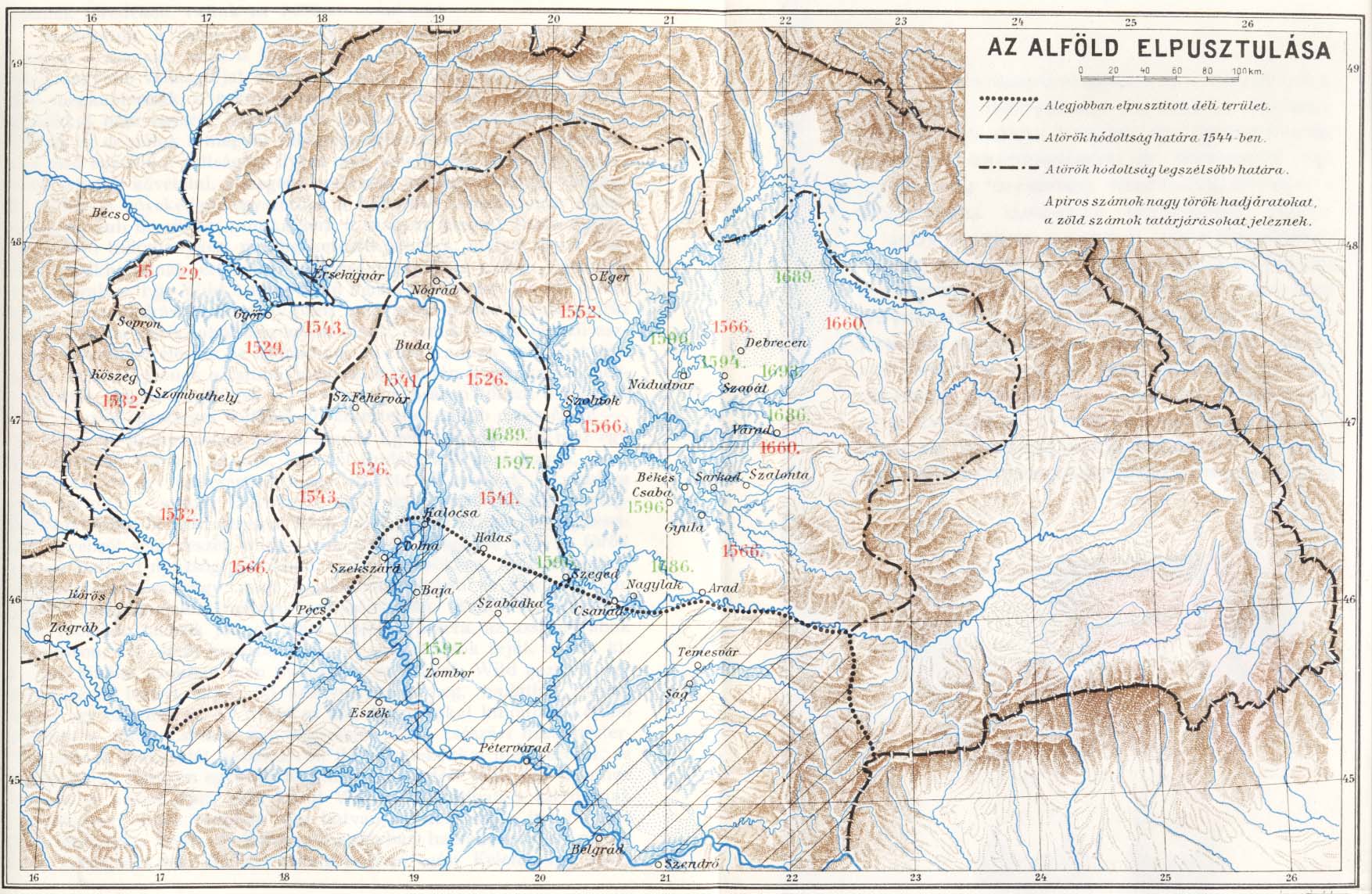
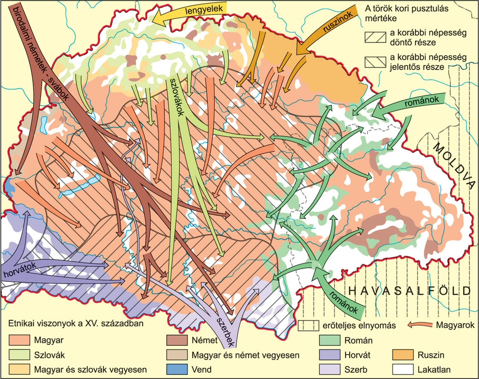
![[12]](/wiki/File:Europe_mediterranean_1097.jpg)
![[11]](/wiki/File:Europe_mediterranean_1190.jpg)
![[32]](https://upload.wikimedia.org/wikipedia/commons/thumb/e/ea/Ethnographic_map_of_hungary_1910_by_teleki_carte_rouge.jpg/1920px-Ethnographic_map_of_hungary_1910_by_teleki_carte_rouge.jpg)
![[34]](https://www.ittjartam.hu/profil/zigzag-images/corner-szerb-etterem-30594-350x262.webp)
![[35]](https://www.semu.hu/wp-content/uploads/2022/04/IMG_0270.jpg)
![[39]](https://commons.wikimedia.org/wiki/File:Kingdom_of_Hungary_-_Ethnic_Map_-_1495.jpg)
![[41]](https://commons.wikimedia.org/wiki/File:Romanians_before_WW1.jpg)
![[42]](https://commons.wikimedia.org/wiki/File:Ethnographic_map_of_hungary_1910_by_teleki_carte_rouge.jpg)
![[43]](https://cdn.imgpile.com/f/MCmx2v3_xl.png)
![[44]](https://karpatmedence.weebly.com/uploads/4/8/8/2/48828655/5299921_orig.jpg)
![[46]](https://upload.wikimedia.org/wikipedia/commons/5/50/The_Ethnological_map_by_Elisee_Reclus.jpg)
We can use it, as a claim, not as a fact. Slatersteven (talk) 10:35, 10 June 2024 (UTC)
- Hi Slatersteven
- What is your opinion about this recently added map? [47] File:FormatiuniPoliticeRomanestiSecolele IX XIII.jpg That is the given source [48] it looks like not an RS modern academic work. That is a Photoshopped user made map based on this nationalcommunist map from 1980 [49] where we can see a Romania country between 800-1400, if we see international Europe maps, you will not find this "Romania" country in the historical maps of Europe: [11][12][13] That maps which made by the national-communist Romanian historiography is clearly a falsifications and abuse of the international and Hungarian historiography, because in the reality that "Romania country" did not exist, which allegedly occupied the half territory of the Kingdom of Hungary between the 800-1400 century. Nationalcommunist histography also claimed Transylvania was not part of Hungary until 1300. However international maps show different things.
- The nationalcommunist dictator Caecescu also celebrated in 1980 the anniversary of Romania in North Korea style and claimed himself of the incarnation of Dacian king Burebista.[50]
- Morover in that Photoshopped map we can see country of Menumorut and other fantasy characters as Romanian countries, those fantasy characters are from Gesta Hungarorum, (btw Menumorut is Bulgarian in the story but he became a Romanian king by the nationalcommunist historiograpy), of course we cannot see these fantasy countries in international history maps.
- Dennis Deletant is a Romanian-British historian has harsh ciritic about this nationalcommunist understanding regarding Gesta Hungarorum. [29] "More extreme in its fancy and tone is the assumption by Lieutenant-General Dr Ilie Ceausescu, brother of the former President and until late the historian with the highest political profile in Romania, that the voivodes Gelou, Glad and Menumorout were Romanians who "succeeded, behind the resistance organized by the communities" population on the border, mobilizing the entire army of the voivodship and meeting (896) the Magyar aggressor shortly after the latter had invaded the Romanian territory. Such abberations by champions of Anonymus serve not only to provide ammunition for the opponents of Gelou and the Vlachs, but also bring us back to the realm of the mythos."
- I beleive we are living in the 21st century, not in the nationalcommunist times with obvious history falsifications. OrionNimrod (talk) 18:36, 10 June 2024 (UTC)
- I believe we do not take sides, and put both sides claims (as attributed claims) in the article. As to maps, as there is some dispute maybe leave all of them out and let the text speak for them. Slatersteven (talk) 18:43, 10 June 2024 (UTC)
![[13]](/wiki/File:Europe_in_the_14th_Century.jpg)
- This is what an old ethnic map should look like [51] [52]. Simple and vague. It doesn't claim accuracy to the smallest detail. The sloppiness of the borders and lack of details also lets it open for interpretation to the observer to assume there might have been small ethnic enclaves or other kind of small details while still giving the observer a general idea. Of course though, nobody disputes Armenians were a dominant population in eastern Anatolia and Cilicia in the past, so those maps are also devoid of the controversy factor present here. Super Ψ Dro 20:57, 10 June 2024 (UTC)
- That map is a modern Hungarian academic map, represent the Hungarian historiography regarding Hungary which is the standard academic mainstream Hungarian view and not extreme, it is also marked that this is the Hungarian view. That map is RS, and that is the original research that you would like to cenzor and supervise scholarship from other country because you dont like it. It is clearly marked that is the Hungarian claim. OrionNimrod (talk) 20:59, 10 June 2024 (UTC)
![[51]](https://en.wikipedia.org/wiki/File:Armenian_presence_within_modern_Turkish_borders_in_early_1600s.png)
- A village-by-village ethnic map of 1495 is excessively speculative. That it represents the Hungarian POV does not fix this issue. Explanation on the making of the map is short and users here are raising potential contradictions to what the map says. I think you should try and look to see if there is a longer explanation somewhere. Because I am still half-skeptic of the fact that they made this map and put two pages as the explanation. Maybe this is why the map has not been discussed outside Hungarian academic circles. Super Ψ Dro 21:11, 10 June 2024 (UTC)
- That is far from that presicion, that is not village by village maps, however much detailed than other maps. OrionNimrod (talk) 21:14, 10 June 2024 (UTC)
- The 1495 map we're discussing is exactly village-by-village. One can even see different colors within each municipality/commune, as it addresses the smallest possible unit. Super Ψ Dro 21:17, 10 June 2024 (UTC)
- The authors are well respected scholars, with more academic memberships, many decades experience in the field in deep knowledge in the settlements, I dont think how can they explain you the long and deep and various researches how they got the result. I think we need to get similar level scholar experince to supervise and feedback them.
- Even I showed you some fast examples regarding the 1784 map, where everyting was matching where the Serbs, Germans, Croats, Slovaks lived at that time.
- And still this is the RS mainstream Hungarian historiography in every works that the Hungarian population changed due to the long wars and internal migration, you cannot deny the existence of this historiography regarding their own country. OrionNimrod (talk) 21:23, 10 June 2024 (UTC)
- So what are those units marked by continuous line? They do not seem to be villages or properties as many of them are left white. Aristeus01 (talk) 21:28, 10 June 2024 (UTC)
- Hi Super, [53] You cannot deny that is the Hungarian claim, there are hundred of Hungarian and foreign sources which know that the Hungarian population devastated during Ottoman wars, do you deny this devastation and destruction of Hungarian settlements by Ottomans? The destruction of many Hungarian settlements by Ottomans is fact, or do you deny this? Also it is fact that Serbs, Slovaks, Croats, Germans was settled on certain regions, which I showed above, do you deny this fact? What is these things if not the ethnic pattern change? OrionNimrod (talk) 21:33, 10 June 2024 (UTC)
- Clearly in the marked source, the ethnic pattern changed because of the wars and migrations: https://www.mtafki.hu/konyvtar/karpat-pannon2015/pdf/Changing_Ethnic_Pattern_Carpatho_Pannonian_Area_2015.pdf How can be "allegedly" if this info in the marked source? OrionNimrod (talk) 21:38, 10 June 2024 (UTC)
- This is common practice in Wikipedia for cases that might be controversial. The word is simply continuing the atributtion. The caption states who made the author but it must also explain their rationale and not present it as a fact. It can be worded differently if necessary but there's not a whole lot different to do. The map doesn't only show alterations in the distribution of Germans and Serbs. The caption was also claiming Transylvania stopped having a Hungarian ethnic majority from 1495 to 1784 due to wars. Contemporary sources do not give us clear proof of this. Super Ψ Dro 21:51, 10 June 2024 (UTC)
- Hi Super, if you interested I reccomend this big Transylvania book to understand the Hungarian view https://mek.oszk.hu/03400/03407/html/index.html and we have many sources about Transylvanian populaton change, like many wars in Transylvania, and migrations in 1600s, 1700s, also there are many sources which say how former Hungarian populated settlemend populated now by Romanians. But it does not matter if we make a talk about it, it is well known Hungarian and Romanian view is different. So we need present both academic views. OrionNimrod (talk) 21:58, 10 June 2024 (UTC)
- Btw why do you suppose that if they know how Serbs, Slovaks, Germans settled on certain areas, that they have no researches of the Transylvanian area? OrionNimrod (talk) 22:04, 10 June 2024 (UTC)
- @Super Dromaeosaurus, can you explain how is the map excessively speculative? Don't the methods used by the academy (e.g. inhabitants' names) allow village-by-village reconstruction of the country's ethnography? Gyalu22 (talk) 11:37, 11 June 2024 (UTC)
- Aristeus01 had noted the possible problems with the use of tax-payer names. The names and the ethnicity they have been attributed are not disclosed. Out of thousands or possibly millions of names there must surely be cases in which other scholars or institutions could disagree arguing their point but that is not possible because data is not disclosed. We are not told what could happen in case data is contradictory, e.g. what if a toponym indicates a certain origin but tax-payers indicate another, or are evenly split in half. There are many white areas in minority-populated places, and Aristeus01 noted one case in which a village that had already been mentioned for the first time four years prior is marked as white. The map attempts to reconstruct the ethnic composition of an entire kingdom to the smallest detail for a time period over 500 years ago without any actual sources confirming without a doubt ethnic and/or linguistic affiliation. Other scholars and institutions have not attempted to reconstruct village-by-village maps for periods of time long ago nor has this map received much attention outside Hungarian academic circles. It makes an exceptional claim with weak, undisclosed sources and methods which have not been repeated by others. I again note that the use of white areas seems pretty much done in bad faith and to prove the POV pushed by the authors. Super Ψ Dro 12:03, 11 June 2024 (UTC)
- I think it's good that all maps got removed. Better this than using speculative information. Alternatively, if speculative information should be used, it should be clearly mentioned that it is speculative and the method used for the said speculation. TheThorLat (talk) 19:55, 11 June 2024 (UTC)
- Aristeus01 had noted the possible problems with the use of tax-payer names. The names and the ethnicity they have been attributed are not disclosed. Out of thousands or possibly millions of names there must surely be cases in which other scholars or institutions could disagree arguing their point but that is not possible because data is not disclosed. We are not told what could happen in case data is contradictory, e.g. what if a toponym indicates a certain origin but tax-payers indicate another, or are evenly split in half. There are many white areas in minority-populated places, and Aristeus01 noted one case in which a village that had already been mentioned for the first time four years prior is marked as white. The map attempts to reconstruct the ethnic composition of an entire kingdom to the smallest detail for a time period over 500 years ago without any actual sources confirming without a doubt ethnic and/or linguistic affiliation. Other scholars and institutions have not attempted to reconstruct village-by-village maps for periods of time long ago nor has this map received much attention outside Hungarian academic circles. It makes an exceptional claim with weak, undisclosed sources and methods which have not been repeated by others. I again note that the use of white areas seems pretty much done in bad faith and to prove the POV pushed by the authors. Super Ψ Dro 12:03, 11 June 2024 (UTC)
- Hi Super, if you interested I reccomend this big Transylvania book to understand the Hungarian view https://mek.oszk.hu/03400/03407/html/index.html and we have many sources about Transylvanian populaton change, like many wars in Transylvania, and migrations in 1600s, 1700s, also there are many sources which say how former Hungarian populated settlemend populated now by Romanians. But it does not matter if we make a talk about it, it is well known Hungarian and Romanian view is different. So we need present both academic views. OrionNimrod (talk) 21:58, 10 June 2024 (UTC)
- This is common practice in Wikipedia for cases that might be controversial. The word is simply continuing the atributtion. The caption states who made the author but it must also explain their rationale and not present it as a fact. It can be worded differently if necessary but there's not a whole lot different to do. The map doesn't only show alterations in the distribution of Germans and Serbs. The caption was also claiming Transylvania stopped having a Hungarian ethnic majority from 1495 to 1784 due to wars. Contemporary sources do not give us clear proof of this. Super Ψ Dro 21:51, 10 June 2024 (UTC)
- Clearly in the marked source, the ethnic pattern changed because of the wars and migrations: https://www.mtafki.hu/konyvtar/karpat-pannon2015/pdf/Changing_Ethnic_Pattern_Carpatho_Pannonian_Area_2015.pdf How can be "allegedly" if this info in the marked source? OrionNimrod (talk) 21:38, 10 June 2024 (UTC)
- Aristeus01 Please contact with the academy for explanation https://mta.hu/english OrionNimrod (talk) 21:35, 10 June 2024 (UTC)
- So you don't know either. Never mind, @OrionNimrod, thanks for the link. I'll keep searching perhaps I can find an explanation in the sources. Btw, did you know that of those source all but one were written during and before the Communist period? Aristeus01 (talk) 21:48, 10 June 2024 (UTC)
- Why should I know? I am not 40 years experience in the field and deep knowledge on the settlement structure. In Wiki we just publish the academic works, but not we create them. OrionNimrod (talk) 21:51, 10 June 2024 (UTC)
- Btw I see a long mountain in the satelit map next to Zilah which is marked white in the map which you showed [54] OrionNimrod (talk) 21:49, 10 June 2024 (UTC)
- not quite a mountain properly, but a high range called Meseș (Meszes). The top of it is quite steep and indeed not prime real estate, but it is only 3-5 km wide so my question is if such minuscule areas are marked as uninhabited what about the field outside the average village? Why is that marked as inhabited? Aristeus01 (talk) 21:56, 10 June 2024 (UTC)
- I think you can contact with the authors for these questions, their name provided along the map. That map is not my work. OrionNimrod (talk) 22:00, 10 June 2024 (UTC)
- not quite a mountain properly, but a high range called Meseș (Meszes). The top of it is quite steep and indeed not prime real estate, but it is only 3-5 km wide so my question is if such minuscule areas are marked as uninhabited what about the field outside the average village? Why is that marked as inhabited? Aristeus01 (talk) 21:56, 10 June 2024 (UTC)
- So you don't know either. Never mind, @OrionNimrod, thanks for the link. I'll keep searching perhaps I can find an explanation in the sources. Btw, did you know that of those source all but one were written during and before the Communist period? Aristeus01 (talk) 21:48, 10 June 2024 (UTC)
- Hi Super, [53] You cannot deny that is the Hungarian claim, there are hundred of Hungarian and foreign sources which know that the Hungarian population devastated during Ottoman wars, do you deny this devastation and destruction of Hungarian settlements by Ottomans? The destruction of many Hungarian settlements by Ottomans is fact, or do you deny this? Also it is fact that Serbs, Slovaks, Croats, Germans was settled on certain regions, which I showed above, do you deny this fact? What is these things if not the ethnic pattern change? OrionNimrod (talk) 21:33, 10 June 2024 (UTC)
- The 1495 map we're discussing is exactly village-by-village. One can even see different colors within each municipality/commune, as it addresses the smallest possible unit. Super Ψ Dro 21:17, 10 June 2024 (UTC)
- That is far from that presicion, that is not village by village maps, however much detailed than other maps. OrionNimrod (talk) 21:14, 10 June 2024 (UTC)
- A village-by-village ethnic map of 1495 is excessively speculative. That it represents the Hungarian POV does not fix this issue. Explanation on the making of the map is short and users here are raising potential contradictions to what the map says. I think you should try and look to see if there is a longer explanation somewhere. Because I am still half-skeptic of the fact that they made this map and put two pages as the explanation. Maybe this is why the map has not been discussed outside Hungarian academic circles. Super Ψ Dro 21:11, 10 June 2024 (UTC)
- Participants!
- I believe this this discussion could go on forever, which each user questioning the authenticity of the other map into eternity.
- And this is for good reason, because there is in fact no historical consensus. And all maps are in fact speculations, different methods were used (that we should mention) but the fact of the matter is we do not know what happened. Historians disagree on what happened, we are not going to solve the long question here on Wikipedia. Nor is it our job to.
- Our job as Wikipedians is simply to provide accurate information for the reader. Given that we have a subject with no academic consensus, I believe the most fair thing to do to our readers is:
- (a) Reach a compromise, the maps with with caveats about their reliability remain, but at the same time they are clearly described as speculative, at the end of the day none of those maps are based on a census, so at the end of the day it is objectively a speculation. It is a field without academic consensus, thus the word "speculation" is necessary to make it clear it's not fact but theory. It's a speculative map.
- (b) One my argue "but this map's research is objectively better", "no, this map's research is more accurate/reliable", and the discussion keeps going. Which is why the 2nd condition should be - the method/basis used for the making of the given maps is mentioned in a specific not general manner. The method itself should be stated, rather than simply saying "research". Of course there are going to be people arguing "this method is biased", "no, this method is biased", but again, this is already what historians do as there is no academic consensus. If we play the "which method is more biased" or "which map is more reliable" we can talk here for years.
- Thus, the reader is offered the information that the given map is speculative and the method in making the given speculative map. And I believe that is fair in a field where there is no academic consensus.
- If you're looking for a factual map of Transylvania that is based on undeniable/uninterpretable evidence before the 1850s census and that all historians, both but not limited to Hungarians and Romanians, agree upon, it doesn't exist.
- In my humble opinion, we should keep a neutral point of view and treat the maps like the rest of the article, both versions are mentioned, stated as "speculative" since that is what they are and the reader should know that for both of them, and with the method for the making of each map described. This way neither the Hungarian viewpoint or the Romanian viewpoint is removed, but no viewpoint is mentioned as an "objective fact" but rather as a speculation based on this ___ method. [55] (talk) 23:42, 10 June 2024 (UTC)
- You cannot compare those maps in term of quality, the Romanian map is just a romantic nationalistic fantasy map which claim the slogan that "2000+ years old" Romania should be between Tisza-Dneister, that map claim that Gelou, Glad and Bulgarian Menmarot had a Romanian kingdom, those are fiction characters in centuries later written medieval Gesta Hungarorum. Those characters and states are unknown by archeology and any other sources. Morover an blatant history falsification on many similar map Romanian nationalistic maps where the border of Hungary is the Tisza river until 1400. Morover I dont see that mystic big Romania between 800-1400 in international history maps. Perhaps is this the modern academic Romanian view today as it was in the nationalcommunist times that Hungary border was the Tisza until 1400? I dont think so. That is why king Saint Ladislaus of Hungary founded and buried in this city far from Tisza in 1090 because until 1400 it was not part of Hungary: Oradea? :D
- The Hungarian demographic map made by many academic experts, many institutions, decades long researches, deep knowledge of settlement structure, (morover not in the dark ages) it is derogatory to label that map as “simple speculation”, they used many method of researches, estimations also. And this was always and still this is the academic mainstream unified Hungarian historiography that the wars changed the ethnic composition of Hungary, which cannot be denied that this is the Hungarian academic view. Also it is fact that vast amount Hungarian settlement destroyed and many population settled in some regions like above I showed examples, Serbs, Croats, Germans, Slovaks, this is also fact and cannot be denied, those are no speculations. OrionNimrod (talk) 08:20, 11 June 2024 (UTC)
- This is what I was talking about that we can debate this into eternity. The Romanian map is based on primary sources mentioning Romanians in those regions such as Gesta Hungarorum, Diploma of the Knights of St. John, Primary Chronicle, Long Life of Saint Gerard, and the Alexiad.
- The reliability of Gesta Hungarorum is pretty much like everything about Transylvania, debate. The fact that you, naturally being a Hungarian, consider it a work of fiction does not change the fact. As you yourself said previously "You cannot cenzor the Hungarian historiography regarding Hungarian history articles just because you dont like the Hungarian academic view", I raise you: "You cannot cenzor the Romanian historiography regarding Romanian history articles just because you dont like the Romanian academic view".
- "I dont think so", think again. The map had a source to the current Romanian school curriculum mentioning the primary sources used for the local autonomies on the map. Once again, just because you dont like the Romanian academic view...
- Regarding "that mystic big Romania between 800-1400" either you exaggerate for dramatic effect or genuinely misunderstood the map. Either way, doesn't matter. Look at the map again as you misunderstood the map.
- The Hungarian demographic map was made by Hungarian historians who had an interest in making Hungary look good. The Romanian autonomies map was made by a Romanian historian who had an interested in making Romania look good.
- At least while I personally believe the Romanian version to be correct don't go around thinking "the Hungarian map is a blatant history falsification" while "the Romanian map was made by experts who knew what they were doing". I like to believe I'm better than that and understand that both have their point of view and used different methods.
- The fact that you personally believe the Romanian map is unreliable because "just a romantic nationalistic fantasy" but the Hungarian map is reliable because "many academic experts, many institutions, decades long researches" says more about you than it says about the maps.
- The Hungarian map, just like the Romanian one, whether you like it or not, are simple speculations. And the reason for that is simple - at the end of the day none of those maps are based on a census, so at the end of the day it is objectively a speculation. The fact that you consider it derogatory to label it as “simple speculation” is simply not impressive, you can consider it however you would like, doesn't change what it is.
- Obviously, you consider the Hungarian method "made by many academic experts, many institutions" based on indirect methods such as linguistic analysis of tax-payers' names and geographic names at the end of the Middle Ages, more reliable than the Romanian method "a romantic nationalistic fantasy map" based on primary sources such as Gesta Hungarorum, Diploma of the Knights of St. John, Primary Chronicle, Long Life of Saint Gerard, and the Alexiad. (Or do you? If you were are proud of the Hungarian method, as you claim to be, why were you in favor of removing the mentioning of the method from the article and simply saying "research" instead? are you ashamed by it? anyway, that's beside the point). To which I go back to what I said in the post you replied to "Historians disagree on what happened, we are not going to solve the long question here on Wikipedia. Nor is it our job to". Our jobs is simply to provide both versions to the reader, you should not get your personal feelings get into the way of making an objective article.
- Regarding this: "And this was always and still this is the academic mainstream unified Hungarian historiography that the wars changed the ethnic composition of Hungary, which cannot be denied that this is the Hungarian academic view. Also it is fact that vast amount Hungarian settlement destroyed and many population settled in some regions like above I showed examples, Serbs, Croats, Germans, Slovaks, this is also fact and cannot be denied, those are no speculations". Well it is in fact denied, and it is in fact speculation. I understand that this is not denied by Hungarian histography. And that's the key thing, by Hungarian histography. This doesn't mean that there is an academic consensus for it outside Hungary.
- Using your own logic, one could equally point out that: "And this was always and still this is the academic mainstream unified Romanian historiography that the Romanians were conquered by the Hungarians and gradually lost their status, which cannot be denied that this is the Romanian academic view. Also it is fact that vast amount Romanian settlements were seized by the Hungarians and given as land to the Catholic Church like Carta, Turda, Zarand, Bihor, Maramures, this is also fact and cannot be denied, those are no speculations".
- Oh, and if you bring the "not all Romanian historians believe in the Daco-Romanian Continuity Theory" neither do all Hungarian Historians believe in the Immigration Theory, except they are not very popular in Hungary for obvious reasons, Andras Magyari for example.
- You see what I mean that we could argue forever? this was my point to begin with.
- I am not going to continue the discussion as I find it rather useless, as I said in the original point, if professional historians couldn't get to a consensus, neither can we.
- My vote is on either:
- - Leave all maps but clearly described as speculative with the method/basis used for the making of the given maps is mentioned in a specific not general manner. As described in the previous post. In other to present both sides' point of view fairly.
- - Remove the maps. TheThorLat (talk) 11:49, 11 June 2024 (UTC)
- Just a side remark, the Long Life of St Gerard does not mention Vlachs/Romanians. It mentions Aitun, a quite obviously nomadic chieftain who had recently converted to Chistianity. The interpretation of the Volochi of the Russian Primary Chronicle as a reference to Vlach is highly cobtroversial, and is rejected by most specialists outside of Romania. Borsoka (talk) 12:02, 11 June 2024 (UTC)
- Continuing the side remark, not related to the discussion about the maps.
- I am not familiar with Long Life of St Gerard so I will not pronounce on it, the source says the following: "Continuity in the formation of Gelu through Gyla (refuses Christianity in the Catholic rite) and that of Glad through Ahtum (which customs the salt of the Hungarian royalty, which descends on Mureş; defeated by the Hungarians, its territory is occupied) is affirmed by the source Life of Saint Gerard, for the 11th century."
- With the Russian Primary Chronicle I am more familiar. Naturally the source says that the Volochi are Vlachs as this is the view of Romanian histography. But I remember reading non-Romanians who also supported the idea that the Volochi are Vlachs such as Demetrius Dvoichenko-Markov, Ivelin A. Ivanov and Aleksander Paron. Demetrius says the following: "The first chronicle in Europe to place the Vlachs in Eastern Europe, according to most of the historians, is considered to be the ancient Russian chronicle of Kiev known also as The Chronicle of Nestor or The Russian Primary Chronicle". According to most of the historians. TheThorLat (talk) 12:33, 11 June 2024 (UTC)
- Hi TheThorLat,
- Your map is not an academic map at all, but an user made photoshopped map. Please show me modern academic Romanian map (not a nationalcommunist one)! While the Hungarian map is a modern, published by Hungarian Academy of Science, based decades long researches by many scholars and institutions. You cannot compare the two maps in term of quality.
- Also your map has not based on researches, just nationalistic Romanians claims that Gelou, Glad, Menmarot were Romanian kings so their land was a Romanian country...then they painted everything as Romanian country from Tisza-Dnester. Still I do not know how Menmarot became Romanian if the Gesta clearly say he was Bulgarian... so it seams the Romanians are deny Gesta who arbitrary make a Romanian king from a Bulgarian character. Also Gesta says Szekelys are remaining Huns in Transylvania, again Romanians deny this. They basically deny everything in the Gesta, just they claim that some blurry words "blasij" (in the original text) means only Romanian, so Gelou became instantly Romanian... Btw I like Gesta Hungarorum, and I dont deny, historians analize the text, for example Arpad and Saint Stephen is a real person in the text, but Menmarot considered a fiction enemy. Cumans also in the story however they appeared 200 years later after the conquest.
- Carlile Aylmer Macartney, British historian: The medieval Hungarian historians: a critical and analytical guide: [56] "All Rumanian medievalists refer to Anon, but none of them is worth reading on the subject" + "this is not evidence that he introduced the whole person of Gelou or the presence of Vlachs in Transylvania"
- Dennis Deletant is a Romanian-British historian, he has harsh ciritic about that nationalcommunist understanding regarding Gesta Hungarorum. [29] "More extreme in its fancy and tone is the assumption by Lieutenant-General Dr Ilie Ceausescu, brother of the former President and until late the historian with the highest political profile in Romania, that the voivodes Gelou, Glad and Menumorout were Romanians who "succeeded, behind the resistance organized by the communities" population on the border, mobilizing the entire army of the voivodship and meeting (896) the Magyar aggressor shortly after the latter had invaded the Romanian territory. Such abberations by champions of Anonymus serve not only to provide ammunition for the opponents of Gelou and the Vlachs, but also bring us back to the realm of the mythos."
- The Nestor chronicle clearly discredits the Daco-Romanian theory. It say "first the Slavs" settled, then the Volochi attacked the Slavs, so how can be these Volochi ancient Daco-Romans if the Slavs settled first who arrived after the Huns? Morover it talks about Danubian Slavs, and not about Transylvania, morover Volochi also mentioned next to England, that is why majority of historians claim Volochi means Franks. In the text the Hungarians expelled the Volochi and settled among the Slavs, so not among the Volochi, and we know the Hungarians attacked the East Franks and expelled them from Pannonia.
- "Also it is fact that vast amount Romanian settlements were seized by the Hungarians and given as land to the Catholic Church like Carta, Turda, Zarand, Bihor, Maramures"
- Really? Despite nobody know about them or about their settlements...
- British historian, Martyn Rady: [57]"The sources consistently refer to Wallachia as being a largely uninhabited woodland before the thirteenth century, and, until this time, they contain no explicit references to Vlachs either here or anywhere in Hungary and Transylvania."
- "neither do all Hungarian Historians believe in the Immigration Theory"
- Sorry but I dont know any Hungarian scholars who accept the nationalistic Daco-Roman theory. Martyn Rady (same book) again: "Hungarian historians universally maintain, that the sudden entry of the Vlachs into the Hungarian historical record around 1200 was a consequence of Romanian immigration from the Balkan interior"
- "Well it is in fact denied, and it is in fact speculation. I understand that this is not denied by Hungarian histography. And that's the key thing, by Hungarian histography. This doesn't mean that there is an academic consensus for it outside Hungary."
- Examples:
- Do you deny that Székesfehérvár (Basilica of the Assumption of the Blessed Virgin Mary) was destroyed by Ottomans? Show me that any academic scholar deny this!
- Do you deny that Buda was destroyed by Ottoman wars and lost their Hungarian population and Germans were settled there after the reconquest and in the 19th century Hungarians slowly became the majority? It is presented in the 1784 map that Buda had German population: [58] Show me that any academic scholar deny this!
- Do you deny that Szentendre city north from Budapest (very far from WW1 Serbia) was called the "Serb city" because many Serbs moved there after Turkish wars Great Migrations of the Serbs, (Serb restaurant, Serb chatedral... [34] [35], I think is hard to image but north from Budapest there ae Orthodox Serbs Cyrillic texts, [36] [37]). Show me that any academic scholar deny this!
- Do you deny that village is about still 40% Croatian close to Vienna next to Austrian border and far from Croatia to https://hu.wikipedia.org/wiki/Kópháza It is presented in the 1784 map that area had Croatian population: [59] Show me that any academic scholar deny this!
- Do you deny that Szarvas in the center of Great Hungarian Plain far from Slovak area became a big Slovak city after the Ottoman wars. It is presented in the 1784 map that area had Slovak population: [60] Show me that any academic scholar deny this!
- Do you deny that Baranya region was settled by Germans after the Ottoman wars Swabian Turkey? It is presented in the 1784 map that area had German population: [61] Show me that any academic scholar deny this!
- Which degree of academic experience, certification and level do you have in the field of the settlement structure in the Carpathian Basin to decide that the Hungarian academic has not knowledge/date/researches of the Hungarian settlements (or former Hungarian settlements)? OrionNimrod (talk) 20:01, 11 June 2024 (UTC)
- I am not here to debate, as I am the opinion this debate will go nowhere. As I was telling you previously, I'm done with the discussion as I consider it rather useless, if professional historians couldn't get to a consensus, neither can we.
- And as a side note, you do not seem to know what the Romanian histography's position is, yet you call it "national communist stance", how can you be certain it is a national communist stance if you do not know what the Romanian histography's position is? The claim that Gelou, Glad, Menmarot were Romanian kings so their land was a Romanian country is the Romanian histography's position. You cannot cenzor the Romanian historiography regarding Romanian history articles just because you dont like the Romanian academic view. This is not to start a debate on the subject but simply pointing out to you that you do not seem to know what the Romanian histography's position is.
- "Sorry but I dont know any Hungarian scholars who accept the nationalistic Daco-Roman theory". Your lack of knowledge is irrelevant, I don't know Korean either, doesn't mean Korean doesn't exist. What is curious is that you do not know any especially after I named you one in the comment you just replied to "neither do all Hungarian Historians believe in the Immigration Theory, except they are not very popular in Hungary for obvious reasons, Andras Magyari for example". It seems you just ignored it. Which reinforces the idea that this is not a discussion worth having.
- Moreover, regarding your claim that the Daco-Roman theory is a "nationalistic" one, most scholarship outside of Romania accepts the Daco-Roman continuity theory. In fact it is more predominant, when foreign historians talk about Romanians and their origins they almost never mention the immigration theory. From memory right now I can tell Dennis Deletant (Which you quoted, so you know he accepts the Daco-Roman theory, but didn't mention it. And instead said the opposite. You contradicted in another passage the very historian you quoted in other passage. Combine this with you being so proud of the Hungarian method, as you claim to be, yet being in favor of removing the mentioning of the method from the article and simply saying "research" instead, as if you are ashamed of it or don't really believe in the method as much as you claim. These inconsistent behaviors don't add up unless there is an intellectual dishonesty for nationalistic reasons involved) and Keith Hitchins as non-Romanian authors supporting the theory. All evidence seems to point out you are the nationalistic one. Which once again, likely more reason this discussion won't go anywhere even if the discussion wouldn't be useless in the first place.
- My vote is on either:
- - Leave all maps but clearly described as speculative with the method/basis used for the making of the given maps is mentioned in a specific not general manner. As described in the previous post. In other to present both sides' point of view fairly.
- - Remove the maps
- My reply to Borsoka was purely based on the two sources side remark unrelated to the maps. TheThorLat (talk) 23:38, 11 June 2024 (UTC)
- If you keep repeating “Romanian academic view” then show modern (not from communist times) academic maps. Your map is still an user made map while the Hungarian one was published by Hungarian academy made by several scholars.
- Also that is the demographic research section as you can see.
- I showed above also examples that is not true that DacoRoman theory would the dominant outside Romania in the academic circles.
- I think not need to debate more about this, the key point the Hungarian map is modern, made by academy and relevant to demographic section to show Hungarian historiography about their own country. So please show modern academic Romanian map, not an user made photoshopped map. OrionNimrod (talk) 07:22, 12 June 2024 (UTC)
- Hi guys! I found an another interactive edition, here less areas are blank (probably they used different ranges), the base map are the today settlements.
- 1495 https://emna.hu/en/map/Km_nyelvi_terszerk_1495/@46.5874817,20.5689702,7.00z
- 1784 https://emna.hu/en/map/Km_nyelvi_terszerk_1784/@46.9210067,22.2978826,7.00z OrionNimrod (talk) 19:54, 12 June 2024 (UTC)
![[58]](https://upload.wikimedia.org/wikipedia/commons/2/25/Kingdom_of_Hungary_-_Ethnic_Map_-_1784.jpg)