The Blue Marble, a photograph of the planet Earth made on 7 December 1972 by the crew of the Apollo 17 spacecraft.
The world is the totality of entities, the whole of reality, or everything that exists. The nature of the world has been conceptualized differently in different fields. Some conceptions see the world as unique while others talk of a "plurality of worlds". Some treat the world as one simple object while others analyze the world as a complex made up of parts.
In scientific cosmology, the world or universe is commonly defined as "[t]he totality of all space and time; all that is, has been, and will be". Theories of modality talk of possible worlds as complete and consistent ways how things could have been. Phenomenology, starting from the horizon of co-given objects present in the periphery of every experience, defines the world as the biggest horizon or the "horizon of all horizons". In philosophy of mind, the world is contrasted with the mind as that which is represented by the mind. Theology conceptualizes the world in relation to God, for example, as God's creation, as identical to God or as the two being interdependent. In religions, there is a tendency to downgrade the material or sensory world in favor of a spiritual world to be sought through religious practice. A comprehensive representation of the world and our place in it, as is found in religions, is known as a worldview. Cosmogony is the field that studies the origin or creation of the world while eschatology refers to the science or doctrine of the last things or of the end of the world.
A treaty may also be known as an international agreement, protocol, covenant, convention, pact, or exchange of letters, among other terms. However, only documents that are legally binding on the parties are considered treaties under international law. Treaties vary in their obligations (the extent to which states are bound to the rules), precision (the extent to which the rules are unambiguous), and delegation (the extent to which third parties have authority to interpret, apply and make rules). (Full article...)
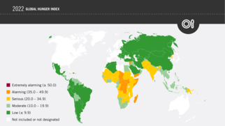
2022 Global Hunger Index by Severity The Global Hunger Index (GHI) is a tool that attempts to measure and track hunger globally as well as by region and by country, prepared by European NGOs of Concern Worldwide and Welthungerhilfe. The GHI is calculated annually, and its results appear in a report issued in October each year.
The 2022 Global Hunger Index shows a dramatic hunger situation worldwide. Global progress in ending hunger is at a near standstill. The main drivers of hunger are conflicts, the climate crisis, and the economic consequences of the COVID-19 pandemic. These drivers come on top of underlying factors such as poverty, inequality, and inadequate governance. (Full article...)
Image 5
Painting of a turn-of-century trading fair, Hessisches Volksfest (Hessian Folk Festival), 1887, Louis Toussaint (1826–1887), Öl auf Leinwand. Cultural globalization refers to the transmission of ideas, meanings and values around the world in such a way as to extend and intensify social relations. This process is marked by the common consumption of cultures that have been diffused by the Internet, popular culture media, and international travel. This has added to processes of commodity exchange and colonization which have a longer history of carrying cultural meaning around the globe. The circulation of cultures enables individuals to partake in extended social relations that cross national and regional borders. The creation and expansion of such social relations is not merely observed on a material level. Cultural globalization involves the formation of shared norms and knowledge with which people associate their individual and collective cultural identities. It brings increasing interconnectedness among different populations and cultures. The idea of cultural globalization emerged in the late 1980s, but was diffused widely by Western academics throughout the 1990s and early 2000s. For some researchers, the idea of cultural globalization is reaction to the claims made by critics of cultural imperialism in the 1970s and 1980s. (Full article...)
The term cold war is used because there was no large-scale fighting directly between the two superpowers, but they each supported opposing sides in major regional conflicts known as proxy wars. (Full article...)
On Earth, 99% of glacial ice is contained within vast ice sheets (also known as "continental glaciers") in the polar regions. Glaciers also exist in mountain ranges on every continent other than the Australian mainland, including Oceania's high-latitude oceanic island countries such as New Zealand. Glacial bodies larger than 50,000 km2 (19,000 sq mi) are called ice sheets. They are several kilometers deep and obscure the underlying topography. (Full article...)
Image 7Change in average surface air temperature and drivers for that change. Human activity has caused increased temperatures, with natural forces adding some variability. (from Earth)
Image 8Artist's impression of Earth during the later Archean, the largely cooled planetary crust and water-rich barren surface, marked by volcanoes and continents, features already roundmicrobialites. The Moon, still orbiting Earth much closer than today and still dominating Earth's sky, produced strong tides. (from History of Earth)
Image 21Earth's western hemisphere showing topography relative to Earth's center instead of to mean sea level, as in common topographic maps (from Earth)
Image 22A schematic view of Earth's magnetosphere with solar wind flowing from left to right (from Earth)
Image 25Shanghai. China urbanized rapidly in the 21st century.
Image 26Geologic map of North America, color-coded by age. From most recent to oldest, age is indicated by yellow, green, blue, and red. The reds and pinks indicate rock from the Archean.
Image 27The Pantheon, originally a Roman temple, now a Catholic church
Image 28Pillar erected by India's Maurya Emperor Ashoka
Image 41An artist's impression of ice age Earth at glacial maximum. (from History of Earth)
Image 42Empires of the world in 1898
Image 43A 2012 artistic impression of the early Solar System's protoplanetary disk from which Earth and other Solar System bodies were formed (from Earth)
Image 44Artist's rendition of an oxinated fully-frozen Snowball Earth with no remaining liquid surface water. (from History of Earth)
Image 45Conjectured illustration of the scorched Earth after the Sun has entered the red giant phase, about 5–7 billion years from now (from Earth)
Image 46Earth's night-side upper atmosphere appearing from the bottom as bands of afterglow illuminating the troposphere in orange with silhouettes of clouds, and the stratosphere in white and blue. Next the mesosphere (pink area) extends to the orange and faintly green line of the lowest airglow, at about one hundred kilometers at the edge of space and the lower edge of the thermosphere (invisible). Continuing with green and red bands of aurorae stretching over several hundred kilometers. (from Earth)
Image 53Earth's axial tilt causing different angles of seasonal illumination at different orbital positions around the Sun (from Earth)
Image 54An animation of the changing density of productive vegetation on land (low in brown; heavy in dark green) and phytoplankton at the ocean surface (low in purple; high in yellow) (from Earth)
Image 59The replicator in virtually all known life is deoxyribonucleic acid. DNA is far more complex than the original replicator and its replication systems are highly elaborate. (from History of Earth)
Image 62Artist's impression of a Hadean landscape with the relatively newly formed Moon still looming closely over Earth and both bodies sustaining strong volcanism. (from History of Earth)
Image 63First airplane, the Wright Flyer, flew on 17 December 1903.
Image 65Tiktaalik, a fish with limb-like fins and a predecessor of tetrapods. Reconstruction from fossils about 375 million years old. (from History of Earth)
Image 66Trilobites first appeared during the Cambrian period and were among the most widespread and diverse groups of Paleozoic organisms. (from History of Earth)
Image 67Pangaea was a supercontinent that existed from about 300 to 180 Ma. The outlines of the modern continents and other landmasses are indicated on this map. (from History of Earth)
Image 84Exaggerated illustration of Earth's elliptical orbit around the Sun, marking that the orbital extreme points (apoapsis and periapsis) are not the same as the four seasonal extreme points, the equinox and solstice (from Earth)
Image 85Angkor Wat temple complex, Cambodia, early 12th century
Image 88A reconstruction of human history based on fossil data. (from History of Earth)
Image 89Map of peopling of the world (Southern Dispersal paradigm), in thousands of years ago.
Image 90A view of Earth with its global ocean and cloud cover, which dominate Earth's surface and hydrosphere; at Earth's polar regions, its hydrosphere forms larger areas of ice cover. (from Earth)
Image 91An artist's impression of the Archean, the eon after Earth's formation, featuring round stromatolites, which are early oxygen-producing forms of life from billions of years ago. After the Late Heavy Bombardment, Earth's crust had cooled, its water-rich barren surface is marked by continents and volcanoes, with the Moon still orbiting Earth half as far as it is today, appearing 2.8 times larger and producing strong tides. (from Earth)
Image 92Chloroplasts in the cells of a moss (from History of Earth)
The main protected areas of Croatia are national parks, nature parks and strict reserves. There are 444 protected areas of Croatia, encompassing 9% of the country. Those include 8 national parks in Croatia, 2 strict reserves and 11 nature parks. The most famous protected area and the oldest national park in Croatia is the Plitvice Lakes National Park, a UNESCO World Heritage Site. Velebit Nature Park is a part of the UNESCO Man and the Biosphere Programme. The strict and special reserves, as well as the national and nature parks, are managed and protected by the central government, while other protected areas are managed by counties. In 2005, the National Ecological Network was set up, as the first step in preparation of the EU accession and joining of the Natura 2000 network.
The total area of all national parks in the country is 994 km2 (384 sq mi), of which 235 km2 (91 sq mi) is sea surface. Each of the national parks is maintained by a separate institution, overseen and funded by the government ministry of nature conservation and spatial development. The State Institute for Nature Protection provides centralized oversight and expertise. (Full article...)
Image 3
Redwood grove in Redwood National Park According to the California Protected Areas Database (CPAD), in the state of California, United States, there are over 14,000 inventoried protected areas administered by public agencies and non-profits. In addition, there are private conservation areas and other easements. They include almost one-third of California's scenic coastline, including coastal wetlands, estuaries, beaches, and dune systems. The California State Parks system alone has 270 units and covers 1.3 million acres (5,300 km2), with over 280 miles (450 km) of coastline, 625 miles (1,006 km) of lake and river frontage, nearly 18,000 campsites, and 3,000 miles (5,000 km) of hiking, biking, and equestrian trails.
Obtaining an accurate total of all protected land in California and elsewhere is a complex task. Many parcels have inholdings, private lands within the protected areas, which may or may not be accounted for when calculating total area. Also, occasionally one parcel of land is included in two or more inventories. Over 90% of Yosemite National Park for example, is listed both as wilderness by the National Wilderness Preservation System, and as national park land by the National Park Service. The Cosumnes River Preserve is an extreme example, owned and managed by a handful of public agencies and private landowners, including the Bureau of Land Management, the County of Sacramento and The Nature Conservancy. Despite the difficulties, the CPAD gives the total area of protected land at 49,294,000 acres (199,490 km2), or 47.05% of the state (not including easements); a considerable amount for the most populous state in the country. (Full article...)
Protected areas in Tanzania (Hifahdi za Mali hai za Tanzania, in Swahili) are extremely varied, ranging from sea habitats over grasslands to the top of the Kilimanjaro, the tallest mountain in Africa. About a third of the country's total area is protected to a certain degree as a national park, game reserve, marine park, forest reserve or the like. 840 protected areas are spread across 7,330 km2 of ocean and 361,594 km2 of land in Tanzania. The coastal and marine areas are less protected than terrestrial ecosystems, which are given the highest level of protection. Tanzania is one of the world's major biodiversity hotspots thanks to its vast national parks, "the Eastern Arc" mountains, wetlands, coastal forests, marine, and freshwater systems as remarkable reservoirs of plant and animal species. A wide range of endemic species of birds, reptiles, snakes, amphibians, wild coffee variations, and the well-known African violet flower can also be found in Tanzania. (Full article...)
About 5.18% of the area of Romania has a protected status (12,360 km2), including the Danube Delta, which makes half of these areas (2.43% of Romania's area). (Full article...)
The state of Johor in Malaysia is noted for its national parks and forest reserves which preserve virgin rainforests known for its biodiversity and endangered species of animals. Mangrove swamps and coral reefs are also protected within these parks. (Full article...)
Papua New Guinea is home to several protected areas, which receive protection because of their environmental, cultural or similar value.
The total area of Papua New Guinea protected territories is 14,330 km2 (5,530 sq mi), which amounts to approximately 3.07% of the country's territory. The total number of protected areas as 2018 is 71. (Full article...)
Protected areas of Canada consist of approximately 12.1 percent of the nation's landmass and freshwater are considered conservation areas, including 11.4 percent designated as protected areas. Approximately 13.8 percent of Canada's territorial waters are conserved, including 8.9 percent designated as protected areas. Terrestrial areas conserved have increased by 65 percent in the 21st century, while marine areas conserved have increased by more than 3,800 percent.
Conservation and protected areas have different mandates depending on the organization which manages them, with some areas having a greater focus on ecological integrity, historical preservation, public usage, scientific research, or a combination of usages. Some areas such as the Polar Bear Pass, are co-managed and overseen by government and local indigenous agencies. (Full article...)
Image 1A plate tectonics map with volcano locations indicated with red circles
Image 2Only a few of the largest large igneous provinces appear (coloured dark purple) on this geological map, which depicts crustal geologic provinces as seen in seismic refraction data


.svg)

 An artist's rendering of a protoplanetary disk (from History of Earth)
 A map of heat flow from Earth's interior to the surface of Earth's crust, mostly along the oceanic ridges (from Earth)
 Artist's impression of the enormous collision that probably formed the Moon (from History of Earth)
 Pale orange dot, an artist's impression of Early Earth, featuring its tinted orange methane-rich early atmosphere (from Earth)
 Chennakesava Temple, Belur, India
 Change in average surface air temperature and drivers for that change. Human activity has caused increased temperatures, with natural forces adding some variability. (from Earth)
 Artist's impression of Earth during the later Archean, the largely cooled planetary crust and water-rich barren surface, marked by volcanoes and continents, features already round microbialites. The Moon, still orbiting Earth much closer than today and still dominating Earth's sky, produced strong tides. (from History of Earth)
 Notre-Dame de Paris, France
 A composite image of Earth, with its different types of surface discernible: Earth's surface dominating Ocean (blue), Africa with lush (green) to dry (brown) land and Earth's polar ice in the form of Antarctic sea ice (grey) covering the Antarctic or Southern Ocean and the Antarctic ice sheet (white) covering Antarctica. (from Earth)
 A reconstruction of Pannotia (550 Ma). (from History of Earth)
 Dinosaurs were the dominant terrestrial vertebrates throughout most of the Mesozoic (from History of Earth)
 A banded iron formation from the 3.15 Ga Moodies Group, Barberton Greenstone Belt, South Africa. Red layers represent the times when oxygen was available; gray layers were formed in anoxic circumstances. (from History of Earth)
 Ajloun Castle, Jordan

 A pillar at Göbekli Tepe
 Earth's western hemisphere showing topography relative to Earth's center instead of to mean sea level, as in common topographic maps (from Earth)
 A schematic view of Earth's magnetosphere with solar wind flowing from left to right (from Earth)
 A composite image of artificial light emissions at night on a map of Earth (from Earth)
 Shanghai. China urbanized rapidly in the 21st century.
 Geologic map of North America, color-coded by age. From most recent to oldest, age is indicated by yellow, green, blue, and red. The reds and pinks indicate rock from the Archean.
 The Pantheon, originally a Roman temple, now a Catholic church

 Cross-section through a liposome (from History of Earth)
 Earth's land use for human agriculture in 2019 (from Earth)
 Machu Picchu, Inca Empire, Peru
 Standing Buddha from Gandhara, 2nd century CE

 Artist's conception of Devonian flora (from History of Earth)
 Graph showing range of estimated partial pressure of atmospheric oxygen through geologic time (from History of Earth)
 Battle during 1281 Mongol invasion of Japan
 An artist's impression of ice age Earth at glacial maximum. (from History of Earth)
 Empires of the world in 1898
 A 2012 artistic impression of the early Solar System's protoplanetary disk from which Earth and other Solar System bodies were formed (from Earth)
 Artist's rendition of an oxinated fully-frozen Snowball Earth with no remaining liquid surface water. (from History of Earth)
 Earth's night-side upper atmosphere appearing from the bottom as bands of afterglow illuminating the troposphere in orange with silhouettes of clouds, and the stratosphere in white and blue. Next the mesosphere (pink area) extends to the orange and faintly green line of the lowest airglow, at about one hundred kilometers at the edge of space and the lower edge of the thermosphere (invisible). Continuing with green and red bands of aurorae stretching over several hundred kilometers. (from Earth)


 "Lucy", the first Australopithecus afarensis skeleton found. Lucy was only 1.06 m (3 ft 6 in) tall.
 A view of Earth with different layers of its atmosphere visible: the troposphere with its clouds casting shadows, a band of stratospheric blue sky at the horizon, and a line of green airglow of the lower thermosphere around an altitude of 100 km, at the edge of space (from Earth)
 Taj Mahal, Mughal Empire, India
 Earth's axial tilt causing different angles of seasonal illumination at different orbital positions around the Sun (from Earth)
 An animation of the changing density of productive vegetation on land (low in brown; heavy in dark green) and phytoplankton at the ocean surface (low in purple; high in yellow) (from Earth)
 Lithified stromatolites on the shores of Lake Thetis, Western Australia. Archean stromatolites are the first direct fossil traces of life on Earth. (from History of Earth)
 Japanese depiction of a Portuguese carrack. European maritime innovations led to proto-globalization.
 Olmec colossal head, now at the Museo de Antropología de Xalapa
 The replicator in virtually all known life is deoxyribonucleic acid. DNA is far more complex than the original replicator and its replication systems are highly elaborate. (from History of Earth)
 Tracy Caldwell Dyson, a NASA astronaut, observing Earth from the Cupola module at the International Space Station on 11 September 2010 (from Earth)
 A computer-generated image mapping the prevalence of artificial satellites and space debris around Earth in geosynchronous and low Earth orbit (from Earth)
 Artist's impression of a Hadean landscape with the relatively newly formed Moon still looming closely over Earth and both bodies sustaining strong volcanism. (from History of Earth)
 First airplane, the Wright Flyer, flew on 17 December 1903.
 Ming dynasty section, Great Wall of China
 Tiktaalik, a fish with limb-like fins and a predecessor of tetrapods. Reconstruction from fossils about 375 million years old. (from History of Earth)
 Trilobites first appeared during the Cambrian period and were among the most widespread and diverse groups of Paleozoic organisms. (from History of Earth)
 Pangaea was a supercontinent that existed from about 300 to 180 Ma. The outlines of the modern continents and other landmasses are indicated on this map. (from History of Earth)
 Great Mosque of Kairouan, Tunisia, founded 670 CE
 View of Earth from the Moon by the Lunar Reconnaissance Orbiter (from Earth)
 Artist's conception of Hadean Eon Earth, when it was much hotter and inhospitable to all forms of life. (from History of Earth)
 A Benin Bronze head from Nigeria
 Earth's history with time-spans of the eons to scale (from History of Earth)
 Vitruvian Man by Leonardo da Vinci epitomizes the advances in art and science seen during the Renaissance. (from History of Earth)
 Yggdrasil, an attempt to reconstruct the Norse world tree which connects the heavens, the world, and the underworld. (from World)
 Satellite time lapse imagery of Earth's rotation showing axis tilt (from Earth)
 Last Moon landing: Apollo 17 (1972)
 Florence, birthplace of the Italian Renaissance
 Fall of the Berlin Wall, 1989
 Image of the physical world, captured by the Hubble Space Telescope (from World)
 Obelisk of Axum, Ethiopia
 Persepolis, Achaemenid Empire, 6th century BCE
 Angkor Wat temple complex, Cambodia, early 12th century
 Great Pyramids of Giza, Egypt
 A 580 million year old fossil of Spriggina floundensi, an animal from the Ediacaran period. Such life forms could have been ancestors to the many new forms that originated in the Cambrian Explosion. (from History of Earth)
 A reconstruction of human history based on fossil data. (from History of Earth)
 Map of peopling of the world (Southern Dispersal paradigm), in thousands of years ago.
 A view of Earth with its global ocean and cloud cover, which dominate Earth's surface and hydrosphere; at Earth's polar regions, its hydrosphere forms larger areas of ice cover. (from Earth)
 Chloroplasts in the cells of a moss (from History of Earth)


.jpg)


.jpeg)


.jpg)


.jpg)


.svg)


 A plate tectonics map with volcano locations indicated with red circles
 Only a few of the largest large igneous provinces appear (coloured dark purple) on this geological map, which depicts crustal geologic provinces as seen in seismic refraction data
 1516 map of the world by Martin Waldseemüller
 The world map by Gerardus Mercator (1569), the first map in the well-known Mercator projection
 Time zones of the world
 The Goode homolosine projection is a pseudocylindrical, equal-area, composite map projection used for world maps.
 Mollweide projection of the world
 Index map from the International Map of the World (1:1,000,000 scale)
 United Nations Human Development Index map by country (2016)


 Commons
 Wikibooks
 Wikidata
 Wikinews
 Wikiquote
 Wikisource
 Wikispecies
 Wikiversity
 Wikivoyage
 Wiktionary


