| Main Portal page | Indices | Projects |
 |
 |

| |
The Caribbean (/ˌkærɪˈbiːən, kəˈrɪbiən/ KARR-ih-BEE-ən, kə-RIB-ee-ən, locally /ˈkærɪbiːæn/ KARR-ih-bee-an; Spanish: el Caribe; French: les Caraïbes; Dutch: de Caraïben) is a subregion of the Americas that includes the Caribbean Sea and its islands, some of which are surrounded by the Caribbean Sea and some of which border both the Caribbean Sea and the North Atlantic Ocean; the nearby coastal areas on the mainland are sometimes also included in the region. The region is south-east of the Gulf of Mexico and Northern America, east of Central America, and north of South America.
Situated largely on the Caribbean Plate, the region has more than 700 islands, islets, reefs, and cays. Island arcs delineate the northern and eastern edges of the Caribbean Sea: the Greater Antilles in the north and the Lesser Antilles, which includes the Leeward Antilles, in the east and south. The nearby Lucayan Archipelago, comprising The Bahamas and the Turks and Caicos Islands, is considered to be a part of the Caribbean despite not bordering the Caribbean Sea. All the islands in the Antilles plus the Lucayan Archipelago form the West Indies, which is often interchangeable with the term Caribbean. On the mainland, Belize, the eastern and northern coasts of Central and South American countries such as the Bay Islands Department of Honduras, the North and South Caribbean Autonomous Regions of Nicaragua, the Limón Province of Costa Rica, and the Archipelago of San Andrés, Providencia and Santa Catalina of Colombia are also considered culturally Caribbean. French Guiana, Guyana, Panama, and Suriname are often included as parts of the Caribbean due to their political and cultural ties with the region.
Geopolitically, the islands of the Caribbean are often regarded as a subregion of North America, though sometimes they are included in Middle America or left as a subregion of their own; alternately, the term "Caribbean" may have the intended exclusion, or even unintentional inclusion, as part of Latin America. Generally the Caribbean area is organized into 33 political entities, including 13 sovereign states, 12 dependencies, historical disputed territories have existed, and seven other overseas territories. From 15 December 1954 to 10 October 2010, there was a territory known as the Netherlands Antilles composed of five islands, all of which were Dutch dependencies. From 3 January 1958 to 31 May 1962, there was also a short-lived political union called the British West Indies Federation composed of ten English-speaking Caribbean territories, all of which were then British dependencies. (Full article...)
 Good article -

Buena Vista Social Club was a musical ensemble primarily made up of Cuban musicians, formed in 1996. The project was organized by World Circuit executive Nick Gold, produced by American guitarist Ry Cooder and directed by Juan de Marcos González. They named the group after the members' club of the same name in the Buenavista quarter of Havana, a popular music venue in the 1940s. To showcase the popular styles of the time, such as son, bolero and danzón, they recruited a dozen veteran musicians, some of whom had been retired for many years.
The group's eponymous studio album was recorded in March 1996 and released in September 1997, quickly becoming an international success, which prompted the ensemble to perform with a full line-up in Amsterdam and New York in 1998. German director Wim Wenders captured the performance on film for a documentary—also called Buena Vista Social Club—that included interviews with the musicians conducted in Havana. Wenders' film was released in June 1999 to critical acclaim, receiving an Academy Award nomination for Best Documentary feature and winning numerous accolades including Best Documentary at the European Film Awards. This was followed up by a second documentary Buena Vista Social Club: Adios in 2017. (Full article...)Selected geography article -

Trinidad and Tobago (/ˈtrɪnɪdæd ... təˈbeɪɡoʊ/ , /- toʊ-/, TRIN-ih-dad ... tə-BAY-goh, - toh-), officially the Republic of Trinidad and Tobago, is the southernmost island country in the Caribbean. Consisting of the main islands Trinidad and Tobago and numerous much smaller islands, it is situated 11 kilometres (6.8 miles) off the coast of northeastern Venezuela and 130 kilometres (81 miles) south of Grenada. It shares maritime boundaries with Barbados to the east, Grenada to the northwest and Venezuela to the south and west. Trinidad and Tobago is generally considered to be part of the West Indies. The island country's capital is Port of Spain, while its largest and most populous municipality is Chaguanas.
The island of Trinidad was inhabited for centuries by Indigenous peoples before becoming a colony in the Spanish Empire, following the arrival of Christopher Columbus, in 1498. Spanish governor José María Chacón surrendered the island to a British fleet under the command of Sir Ralph Abercromby in 1797. Trinidad and Tobago were ceded to Britain in 1802 under the Treaty of Amiens as separate states and unified in 1889. Trinidad and Tobago obtained independence in 1962, becoming a republic in 1976. (Full article...)Selected fare or cuisine -

Did you know? -

- ...that Isla Margarita (pictured), the largest Caribbean island of the Nueva Esparta State in Venezuela, was seized by Lope de Aguirre, a notoriously violent and rebellious conquistador in 1561? And that he held the islanders in a grip of terror until he returned to the mainland in an attempt to take Panama from the Spanish crown?
- ...that Sociolismo is an informal term used in Cuba to describe the reciprocal exchange of favors by individuals?
- ...that Joséphine de Beauharnais, the first wife of Napoléon Bonaparte and thus the first Empress of the French was born in Les Trois-Îlets, Martinique in 1763?
Related portals
Wikiproject
 Featured article -

Hurricane Hazel was the deadliest, second-costliest, and most intense hurricane of the 1954 Atlantic hurricane season. The storm killed at least 469 people in Haiti before it struck the United States near the border between North and South Carolina as a Category 4 hurricane. After causing 95 fatalities in the US, Hazel struck Canada as an extratropical storm, which raised the death toll by 81 people, mostly in Toronto. As a result of the high death toll and the damage caused by Hazel, its name was retired from use for North Atlantic hurricanes.
In Haiti, Hazel destroyed 40 percent of the coffee trees and 50 percent of the cacao crop, which affected the economy for several years. The hurricane made landfall near Calabash, North Carolina, and destroyed most waterfront dwellings. It then traveled north along the Atlantic coast. Hazel affected Virginia; Washington, D.C.; West Virginia; Maryland; Delaware; New Jersey; Pennsylvania; and New York. It brought gusts near 160 km/h (100 mph) and caused $281 million (1954 USD) in damage. When it was over Pennsylvania, Hazel consolidated with a cold front and turned northwest towards Canada. When it hit Ontario as an extratropical storm, rivers and streams in and around Toronto overflowed their banks, which caused severe flooding. As a result, many residential areas in the local floodplains, such as the Raymore Drive area, were subsequently converted to parkland. In Canada alone, over C$135 million (2023: C$1.5 billion) of damage was incurred. (Full article...)Selected image -

Map of the island of Saint Kitts. Herman Moll, 1729.
Selected music -
Chanté mas (masquerade song) and Lapo kabrit is a form of Carnival music of Dominica. It is performed by masquerading partygoers in a two-day parade, with a lead vocalist (chantwèl), who is followed by the responsorial chorus (lavwa), with drummers and dancers dancing backwards in front of the drummer on a tambou lélé. The Carnival has African and French roots and is otherwise known as Mas Dominik, the most original Carnival in the Caribbean.
Carnival in Dominica is held in the capital city of Roseau, and takes elements of carnival that can be seen in the neighbouring French islands of Martinique and Guadeloupe, as well as Trinidad and Tobago Carnival. Notable events that take place during the season leading up to carnival include "j'ouvert" the opening of Carnival celebrations, the calypso Monarch music competition, the queen of Carnival Beauty Pageant and bouyon music bands. Celebrations last for the Monday and Tuesday before Ash Wednesday. Dominica's carnival is known to be the most original and least commercialized in the Caribbean giving the carnival its name the original mas (Full article...)General images
-
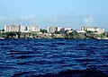
 A container ship docked in the deep water harbour of Bridgetown, Barbados, which opened in 1961. (from History of the Caribbean)
 -
 Linguistic map of the Caribbean in CE 1500, before European colonization (from History of the Caribbean)
 -
 A 1906 advertisement in the Montreal Medical Journal, showing the United Fruit Company selling trips to Jamaica. (from History of the Caribbean)
 -
 Spanish Caribbean Islands in the American Viceroyalties 1600. (from History of the Caribbean)
 -
 A carriage on a street in Martinique, one of the Caribbean islands that has not become independent. It is an overseas region of France, and its citizens are full French citizens. (from History of the Caribbean)
 -
 Crane Resort old and new buildings, Cobblers Reef, Barbados (from Tourism in Latin America and the Caribbean)
 -
 The Natives of Cumaná attack the mission after Gonzalo de Ocampo's slaving raid. Colored copperplate by Theodor de Bry, published in the "Relación brevissima de la destruccion de las Indias". (from History of the Caribbean)
 -
 A medallion showing the Capture of Trinidad and Tobago by the British in 1797. (from History of the Caribbean)
 -
 Sir Ralph Abercromby, Commander of the British forces that captured Trinidad and Tobago. (from History of the Caribbean)
 -
 The Piazza at Havana by Dominic Serres. The Piazza of Havana, Cuba occupied by British troops following the Siege of Havana, in 1762, during the Seven Years' War. (from History of the Caribbean)
 -
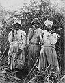 Cane cutters in Jamaica, 1880s. (from History of the Caribbean)
 -
 American 757 on final approach to Saint Maarten Airport (from Tourism in Latin America and the Caribbean)
 -
 Bath Hotel, Nevis, photograph by Jose Anjo of Antigua (from Tourism in Latin America and the Caribbean)
 -
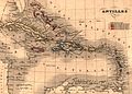 Map of Antilles / Caribbean in 1843. (from History of the Caribbean)
 -
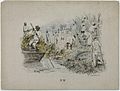
 A linen market in the British West Indies, circa 1780 (from History of the Caribbean)
 -
 Battle of the Saintes by Thomas Mitchell. This 1782 battle between the British and French navies took place near Guadeloupe. (from History of the Caribbean)
 -
-
 Illustration circa 1815 showing "Incendie du Cap" (Burning of Cape Francais) during the Haitian Revolution. The caption reads: "General revolt of the Blacks. Massacre of the Whites". (from History of the Caribbean)
 -
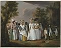 Agostino Brunias. Free Women of Color with Their Children and Servants in a Landscape, ca. 1770-1796 Brooklyn Museum (from Culture of the Caribbean)
 -
 United States' rescue effort at St. Vincent, 1902, following an eruption of the volcano at La Soufrière. (from History of the Caribbean)
 -
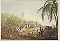
 A 19th-century lithograph by Theodore Bray showing a sugarcane plantation. On right is "white officer", the European overseer, surveilling plantation workers. To the left is a flat-bottomed vessel for cane transportation. (from History of the Caribbean)
 -
 Political evolution of Central America and the Caribbean from 1700 to present (from History of the Caribbean)
 -

-
-
 Contemporary political map of the Caribbean (from History of the Caribbean)
 -
 The forced African migrants brought to the Caribbean lived in inhumane conditions. Above are examples of slave huts in Dutch Bonaire. About 5 feet tall and 6 feet wide, between 2 and 3 slaves slept in these after working in nearby salt mines. (from History of the Caribbean)


,_plate_IV_-_BL.jpg)
.jpg)


Caribbean topics
Categories

New articles
Rules | Match log | Results page (for watching) | Last updated: 2024-06-12 19:46 (UTC)
Note: The list display can now be customized by each user. See List display personalization for details.
- Eusebio Puello (edit | talk | history | links | watch | logs | tools) by BlkGeneral2000 (talk · contribs · new pages (1)) started on 2024-06-11, score: 92
- 1964 New York World's Fair pavilions (edit | talk | history | links | watch | logs | tools) by Epicgenius (talk · contribs · new pages (38)) started on 2024-06-05, score: 16
- Emerging Ireland cricket team (edit | talk | history | links | watch | logs | tools) by Godknowme1 (talk · contribs · new pages (1)) started on 2024-06-11, score: 32
- 2022–23 Liga Puerto Rico season (edit | talk | history | links | watch | logs | tools) by Yeahimaboss413 (talk · contribs · new pages (6)) started on 2024-06-11, score: 43
- 2023–24 Liga Puerto Rico season (edit | talk | history | links | watch | logs | tools) by Yeahimaboss413 (talk · contribs · new pages (6)) started on 2024-06-11, score: 35
- Roberto Durán vs. Esteban de Jesús (edit | talk | history | links | watch | logs | tools) by Beast from da East (talk · contribs · new pages (6)) started on 2024-06-11, score: 16
- The Latin Alternative (Radio Program) (edit | talk | history | links | watch | logs | tools) by TheNuggeteer (talk · contribs · new pages (40)) started on 2024-06-11, score: 16
- Diablos Rojos (bus) (edit | talk | history | links | watch | logs | tools) by TheNuggeteer (talk · contribs · new pages (40)) started on 2024-06-11, score: 16
- He Knows (edit | talk | history | links | watch | logs | tools) by Bryantriplex (talk · contribs · new pages (1)) started on 2024-06-11, score: 16
- Anthony León (tenor) (edit | talk | history | links | watch | logs | tools) by Gor1995 (talk · contribs · new pages (1)) started on 2024-06-10, score: 16
- Paul Noel Fiorino (edit | talk | history | links | watch | logs | tools) by Microplastic Consumer (talk · contribs · new pages (9)) started on 2024-06-08, score: 16
- Gabriele Dell′Oglio (edit | talk | history | links | watch | logs | tools) by Gri3720 (talk · contribs · new pages (7)) started on 2024-06-10, score: 32
- Nikolai Mushegian (edit | talk | history | links | watch | logs | tools) by Consutema (talk · contribs · new pages (1)) started on 2024-06-10, score: 16
- Justice Malone (edit | talk | history | links | watch | logs | tools) by BD2412 (talk · contribs · new pages (667)) started on 2024-06-10, score: 32
- Justice Knowles (edit | talk | history | links | watch | logs | tools) by BD2412 (talk · contribs · new pages (667)) started on 2024-06-10, score: 16
- 2020s in Latin music (edit | talk | history | links | watch | logs | tools) by Magiciandude (talk · contribs · new pages (3)) started on 2024-06-10, score: 16
- Christal (edit | talk | history | links | watch | logs | tools) by Toweli (talk · contribs · new pages (126)) started on 2024-06-10, score: 16
- United Nations General Assembly Resolution 78/282 (edit | talk | history | links | watch | logs | tools) by Srđan (talk · contribs · new pages (1)) started on 2024-06-10, score: 96
- Sofía Cabrera (edit | talk | history | links | watch | logs | tools) by Almagestas (talk · contribs · new pages (8)) started on 2024-06-10, score: 27
- List of British Army first-class cricketers (edit | talk | history | links | watch | logs | tools) by Blue Square Thing (talk · contribs · new pages (8)) started on 2024-06-10, score: 16
- 2024 ICC Men's T20 World Cup Super 8 Group 2 (edit | talk | history | links | watch | logs | tools) by Spinin (talk · contribs · new pages (3)) started on 2024-06-10, score: 40
- Audley Clarke (edit | talk | history | links | watch | logs | tools) by RhodeIslandHistory (talk · contribs · new pages (2)) started on 2024-06-10, score: 16
- Adael Amador (edit | talk | history | links | watch | logs | tools) by Yankees10 (talk · contribs · new pages (22)) started on 2024-06-09, score: 16
- Rainer Kensy, Baron of Echlin (edit | talk | history | links | watch | logs | tools) by Kellycrak88 (talk · contribs · new pages (36)) started on 2024-06-09, score: 24
- Ramon Bailey (edit | talk | history | links | watch | logs | tools) by Shotgun pete (talk · contribs · new pages (1)) started on 2024-06-09, score: 16
- Cortines (edit | talk | history | links | watch | logs | tools) by XxTechnicianxX (talk · contribs · new pages (3)) started on 2024-06-09, score: 16
- May 1978 (edit | talk | history | links | watch | logs | tools) by Mandsford (talk · contribs · new pages (1)) started on 2024-05-30, score: 16
- Michel Otañez (edit | talk | history | links | watch | logs | tools) by Muboshgu (talk · contribs · new pages (14)) started on 2024-06-09, score: 16
- Dale Pa'Ya (edit | talk | history | links | watch | logs | tools) by Shout4Serenity (talk · contribs · new pages (12)) started on 2024-06-09, score: 24
- Rumble (Skrillex, Fred Again and Flowdan song) (edit | talk | history | links | watch | logs | tools) by QuietHere (talk · contribs · new pages (38)) started on 2024-06-09, score: 16
- Musicólogo & Menes (edit | talk | history | links | watch | logs | tools) by Sebaspikyaq (talk · contribs · new pages (2)) started on 2024-06-09, score: 16
- Brickell (song) (edit | talk | history | links | watch | logs | tools) by Sebaspikyaq (talk · contribs · new pages (2)) started on 2024-06-09, score: 16
- Warren Kanders (edit | talk | history | links | watch | logs | tools) by Bridget (talk · contribs · new pages (4)) started on 2024-06-09, score: 16
- Antoine Pierrot (edit | talk | history | links | watch | logs | tools) by EssNS (talk · contribs · new pages (19)) started on 2024-06-08, score: 32
- Junior Senneville (edit | talk | history | links | watch | logs | tools) by Paul Vaurie (talk · contribs · new pages (29)) started on 2024-06-08, score: 24
- Ariamnes mexicanus (edit | talk | history | links | watch | logs | tools) by Fluxjupyter (talk · contribs · new pages (4)) started on 2024-06-08, score: 35
- Cinema of Guinea-Bissau (edit | talk | history | links | watch | logs | tools) by Lbal (talk · contribs · new pages (2)) started on 2024-06-08, score: 16
- Richard Mollica (edit | talk | history | links | watch | logs | tools) by Accotink (talk · contribs · new pages (2)) started on 2024-06-07, score: 16
- Julio Grave de Peralta (edit | talk | history | links | watch | logs | tools) by EssNS (talk · contribs · new pages (19)) started on 2024-06-08, score: 16
- Mora (singer) (edit | talk | history | links | watch | logs | tools) by Bkonrad (talk · contribs · new pages (4)) started on 2024-06-08, score: 16
- If I Ruled the World (Big Time Rush song) (edit | talk | history | links | watch | logs | tools) by Shout4Serenity (talk · contribs · new pages (12)) started on 2024-06-08, score: 16
- 2024 ICC Men's T20 World Cup Super 8 Group 1 (edit | talk | history | links | watch | logs | tools) by Spinin (talk · contribs · new pages (3)) started on 2024-06-08, score: 48
- Juma Miyagi (edit | talk | history | links | watch | logs | tools) by Beeeggs (talk · contribs · new pages (3)) started on 2024-06-08, score: 16
- 2024 ICC Men's T20 World Cup final (edit | talk | history | links | watch | logs | tools) by Spinin (talk · contribs · new pages (3)) started on 2024-06-08, score: 16
- Eric Velásquez (edit | talk | history | links | watch | logs | tools) by Significa liberdade (talk · contribs · new pages (56)) started on 2024-06-08, score: 16
- Gabriel Silva (Panamanian politician) (edit | talk | history | links | watch | logs | tools) by Number 57 (talk · contribs · new pages (17)) started on 2024-06-07, score: 16
- Tonia Sutherland (edit | talk | history | links | watch | logs | tools) by Stephestellar (talk · contribs · new pages (2)) started on 2024-06-07, score: 16
- Schendylops (edit | talk | history | links | watch | logs | tools) by HCUPa (talk · contribs · new pages (10)) started on 2024-06-05, score: 16
- Bordon Camp (edit | talk | history | links | watch | logs | tools) by Dormskirk (talk · contribs · new pages (7)) started on 2024-06-07, score: 24
- 2024 NACAC Championships (edit | talk | history | links | watch | logs | tools) by Habst (talk · contribs · new pages (128)) started on 2024-06-07, score: 32
- Godfrey Nyakana (edit | talk | history | links | watch | logs | tools) by Micheal Kaluba (talk · contribs · new pages (7)) started on 2024-06-07, score: 24
- 2024 CONCACAF Caribbean Cup (edit | talk | history | links | watch | logs | tools) by Demt1298 (talk · contribs · new pages (3)) started on 2024-06-07, score: 71
- Legal career of Keir Starmer (edit | talk | history | links | watch | logs | tools) by ThingsCanOnlyGetWetter (talk · contribs · new pages (40)) started on 2024-06-06, score: 16
- Lenni Cirino (edit | talk | history | links | watch | logs | tools) by Geregen2 (talk · contribs · new pages (42)) started on 2024-06-06, score: 16
- Carlos Ímaz (edit | talk | history | links | watch | logs | tools) by Chiffre01 (talk · contribs · new pages (1)) started on 2024-06-06, score: 16
- Agenodesmus (edit | talk | history | links | watch | logs | tools) by HCUPa (talk · contribs · new pages (10)) started on 2024-06-06, score: 48
- Carlos Imaz Gispert (edit | talk | history | links | watch | logs | tools) by Chiffre01 (talk · contribs · new pages (1)) started on 2024-06-06, score: 16
- Barbara Conolly (edit | talk | history | links | watch | logs | tools) by Moondragon21 (talk · contribs · new pages (52)) started on 2024-06-06, score: 16
- Deaths in May 2024 (edit | talk | history | links | watch | logs | tools) by Rusted AutoParts (talk · contribs · new pages (2)) started on 2024-06-06, score: 32
- Andy Hechavarría (edit | talk | history | links | watch | logs | tools) by Pietaster (talk · contribs · new pages (10)) started on 2024-06-06, score: 24
- Rayvien Rosario (edit | talk | history | links | watch | logs | tools) by Ortizesp (talk · contribs · new pages (29)) started on 2024-06-06, score: 16
- CNN Radio Argentina (edit | talk | history | links | watch | logs | tools) by JuanjoAvalos (talk · contribs · new pages (1)) started on 2024-06-06, score: 32
- List of Seattle Reign FC seasons (edit | talk | history | links | watch | logs | tools) by SounderBruce (talk · contribs · new pages (15)) started on 2024-06-06, score: 16
- Angel Chivilli (edit | talk | history | links | watch | logs | tools) by Muboshgu (talk · contribs · new pages (14)) started on 2024-06-06, score: 16
- 1963 Soviet Union regional elections (edit | talk | history | links | watch | logs | tools) by Tony24644 (talk · contribs · new pages (11)) started on 2024-06-06, score: 16
- 2024 CFU Club Shield (edit | talk | history | links | watch | logs | tools) by Demt1298 (talk · contribs · new pages (3)) started on 2024-06-06, score: 95
- CFU Club Shield (edit | talk | history | links | watch | logs | tools) by Demt1298 (talk · contribs · new pages (3)) started on 2024-06-06, score: 27
- Pachira insignis (edit | talk | history | links | watch | logs | tools) by BlakeALee (talk · contribs · new pages (1)) started on 2024-06-06, score: 32
- Juan Bautista Cambiaso Valdez (edit | talk | history | links | watch | logs | tools) by Scambiaso (talk · contribs · new pages (1)) started on 2024-06-05, score: 16
- 2023 Boys' U17 NORCECA Volleyball Championship (edit | talk | history | links | watch | logs | tools) by Thiago89 (talk · contribs · new pages (5)) started on 2024-06-05, score: 48
- Third Horizon Film Festival (edit | talk | history | links | watch | logs | tools) by MichaelaBlanc (talk · contribs · new pages (2)) started on 2024-06-05, score: 83
- Design 1099 Ship (edit | talk | history | links | watch | logs | tools) by Jordanroderick (talk · contribs · new pages (2)) started on 2024-05-26, score: 40
- Boca (Gaia and Sean Paul song) (edit | talk | history | links | watch | logs | tools) by BeyPolite (talk · contribs · new pages (11)) started on 2024-06-05, score: 16
- Masai Brown (edit | talk | history | links | watch | logs | tools) by Hildreth gazzard (talk · contribs · new pages (197)) started on 2024-06-05, score: 16
- The Bluff (upcoming film) (edit | talk | history | links | watch | logs | tools) by Hildreth gazzard (talk · contribs · new pages (197)) started on 2024-06-05, score: 19
- Dano-Dutch colonial conflict on the Gold Coast (edit | talk | history | links | watch | logs | tools) by Tinkaer1991 (talk · contribs · new pages (26)) started on 2024-06-05, score: 16
- Jeth Rey (edit | talk | history | links | watch | logs | tools) by KingEdinburgh (talk · contribs · new pages (11)) started on 2024-06-05, score: 16
- 2000 Puerto Rico presidential nominating contests (edit | talk | history | links | watch | logs | tools) by Memevietnam98 (talk · contribs · new pages (17)) started on 2024-06-05, score: 32
- 2000 Puerto Rico Republican presidential primary (edit | talk | history | links | watch | logs | tools) by Memevietnam98 (talk · contribs · new pages (17)) started on 2024-06-05, score: 32
- 2000 Puerto Rico Democratic presidential caucuses (edit | talk | history | links | watch | logs | tools) by Memevietnam98 (talk · contribs · new pages (17)) started on 2024-06-05, score: 32
- Shadowland (song) (edit | talk | history | links | watch | logs | tools) by Tbhotch (talk · contribs · new pages (36)) started on 2024-06-05, score: 16
- List of volcanoes in Montserrat (edit | talk | history | links | watch | logs | tools) by CareAhLine (talk · contribs · new pages (2)) started on 2024-06-05, score: 35
- Peter Harrison (philanthropist) (edit | talk | history | links | watch | logs | tools) by Moonraker (talk · contribs · new pages (1)) started on 2024-06-04, score: 40
- Peter Evander McKerrow (edit | talk | history | links | watch | logs | tools) by EssNS (talk · contribs · new pages (19)) started on 2024-06-04, score: 56
- Louis-Pantaléon de Noé (edit | talk | history | links | watch | logs | tools) by Superboilles (talk · contribs · new pages (10)) started on 2024-06-04, score: 32
- List of Alpha Psi Omega chapters (edit | talk | history | links | watch | logs | tools) by Rublamb (talk · contribs · new pages (16)) started on 2024-06-04, score: 48
- Lindemannlaw (edit | talk | history | links | watch | logs | tools) by Dmitry A K (talk · contribs · new pages (2)) started on 2024-06-03, score: 16
- Lance Hayward at the Half Moon Hotel, Volume 2 (edit | talk | history | links | watch | logs | tools) by Tsc9i8 (talk · contribs · new pages (1)) started on 2024-06-04, score: 16
- Woodly Caymitte (edit | talk | history | links | watch | logs | tools) by Roastedbeanz1 (talk · contribs · new pages (14)) started on 2024-06-04, score: 16
- 1822 Costa Rica earthquake (edit | talk | history | links | watch | logs | tools) by Dora the Axe-plorer (talk · contribs · new pages (6)) started on 2024-06-04, score: 16
- 66th Sydney Film Festival (edit | talk | history | links | watch | logs | tools) by Androptrnt (talk · contribs · new pages (4)) started on 2024-06-04, score: 16
- 2001 Haitian coup attempt (edit | talk | history | links | watch | logs | tools) by TheBrowniess (talk · contribs · new pages (13)) started on 2024-06-04, score: 36
- List of volcanoes in the Dutch Caribbean (edit | talk | history | links | watch | logs | tools) by CareAhLine (talk · contribs · new pages (2)) started on 2024-06-04, score: 27
- Alessandro Zorzi (edit | talk | history | links | watch | logs | tools) by Shyamal (talk · contribs · new pages (22)) started on 2024-06-04, score: 16
- 2024 ICC Men's T20 World Cup Group D (edit | talk | history | links | watch | logs | tools) by Vestrian24Bio (talk · contribs · new pages (34)) started on 2024-06-04, score: 24
- 2024 ICC Men's T20 World Cup Group C (edit | talk | history | links | watch | logs | tools) by Vestrian24Bio (talk · contribs · new pages (34)) started on 2024-06-04, score: 24
- Kuprešanin (edit | talk | history | links | watch | logs | tools) by David Eppstein (talk · contribs · new pages (23)) started on 2024-06-04, score: 16
- Del Valle (surname) (edit | talk | history | links | watch | logs | tools) by Altenmann (talk · contribs · new pages (111)) started on 2024-06-03, score: 32
- 2024 ICC Men's T20 World Cup Group B (edit | talk | history | links | watch | logs | tools) by Vestrian24Bio (talk · contribs · new pages (34)) started on 2024-06-03, score: 40
- U-15 Women's Softball World Cup (edit | talk | history | links | watch | logs | tools) by DavidPausini (talk · contribs · new pages (3)) started on 2024-06-02, score: 16
- W. R. Johnson (edit | talk | history | links | watch | logs | tools) by Noswall59 (talk · contribs · new pages (3)) started on 2024-06-01, score: 16
- 2024 FIBA Under-18 Americas Championship (edit | talk | history | links | watch | logs | tools) by Smitty Smitty (talk · contribs · new pages (3)) started on 2024-06-03, score: 16
- Henry Morgan's raid on Lake Maracaibo (edit | talk | history | links | watch | logs | tools) by Eastfarthingan (talk · contribs · new pages (1)) started on 2024-06-03, score: 67
- No Destroyer (edit | talk | history | links | watch | logs | tools) by GanzKnusper (talk · contribs · new pages (1)) started on 2024-06-03, score: 16
- MICAL (edit | talk | history | links | watch | logs | tools) by Moondragon21 (talk · contribs · new pages (52)) started on 2024-06-03, score: 16
- Pedro Esteban González-Larrinaga (edit | talk | history | links | watch | logs | tools) by EssNS (talk · contribs · new pages (19)) started on 2024-06-03, score: 16
- 19th Lima Film Festival (edit | talk | history | links | watch | logs | tools) by Renknight (talk · contribs · new pages (8)) started on 2024-06-03, score: 24
- 2000 U.S. Virgin Islands Democratic presidential caucuses (edit | talk | history | links | watch | logs | tools) by Memevietnam98 (talk · contribs · new pages (17)) started on 2024-06-03, score: 16
- Roberto Durán vs. Héctor Camacho II (edit | talk | history | links | watch | logs | tools) by Beast from da East (talk · contribs · new pages (6)) started on 2024-06-03, score: 16
- Dependent territories of the United Kingdom (edit | talk | history | links | watch | logs | tools) by 109.255.211.6 (talk · contribs · new pages (1)) started on 2024-06-03, score: 40
- Jorge Moreno (edit | talk | history | links | watch | logs | tools) by Tassedethe (talk · contribs · new pages (215)) started on 2024-06-03, score: 16
- Federal Taxpayer Registry (edit | talk | history | links | watch | logs | tools) by Dash9Z (talk · contribs · new pages (1)) started on 2024-06-02, score: 16
- Perfecto Lacoste (edit | talk | history | links | watch | logs | tools) by EssNS (talk · contribs · new pages (19)) started on 2024-06-02, score: 16
- List of countries by price level (edit | talk | history | links | watch | logs | tools) by Afus199620 (talk · contribs · new pages (14)) started on 2024-06-02, score: 48
- 2023 U-15 Women's Softball World Cup (edit | talk | history | links | watch | logs | tools) by DavidPausini (talk · contribs · new pages (3)) started on 2024-06-02, score: 16
- 2024 ICC Men's T20 World Cup Group stage (edit | talk | history | links | watch | logs | tools) by Vestrian24Bio (talk · contribs · new pages (34)) started on 2024-06-02, score: 24
- Automatic (Nicki Minaj song) (edit | talk | history | links | watch | logs | tools) by MemberDecember (talk · contribs · new pages (1)) started on 2024-06-02, score: 16
- Enrique Collazo (general) (edit | talk | history | links | watch | logs | tools) by EssNS (talk · contribs · new pages (19)) started on 2024-06-02, score: 16
- 2024–25 Liga Primera de Nicaragua (edit | talk | history | links | watch | logs | tools) by BKReruns (talk · contribs · new pages (2)) started on 2024-06-02, score: 16
- 2024 ICC Men's T20 World Cup statistics (edit | talk | history | links | watch | logs | tools) by Wowlastic10 (talk · contribs · new pages (2)) started on 2024-06-02, score: 16
- 20th Lima Film Festival (edit | talk | history | links | watch | logs | tools) by Renknight (talk · contribs · new pages (8)) started on 2024-06-02, score: 16
- Brostep (edit | talk | history | links | watch | logs | tools) by SuperPlayer56 (talk · contribs · new pages (1)) started on 2024-05-31, score: 16
- Cijntje (edit | talk | history | links | watch | logs | tools) by Dmoore5556 (talk · contribs · new pages (5)) started on 2024-06-01, score: 16
- Cindy Scott (edit | talk | history | links | watch | logs | tools) by JazzWikiWriter (talk · contribs · new pages (2)) started on 2024-06-01, score: 16
- Bryan Ortiz (edit | talk | history | links | watch | logs | tools) by Finn Shipley (talk · contribs · new pages (10)) started on 2024-06-01, score: 16
- History of Peru (1956–1968) (edit | talk | history | links | watch | logs | tools) by AlejandroFC (talk · contribs · new pages (83)) started on 2024-06-01, score: 16
- List of Alpha Lambda Delta chapters (edit | talk | history | links | watch | logs | tools) by Rublamb (talk · contribs · new pages (16)) started on 2024-06-01, score: 16
- Harrison Skeete (edit | talk | history | links | watch | logs | tools) by Voerknecht (talk · contribs · new pages (2)) started on 2024-05-31, score: 24
- Justin Sterner (edit | talk | history | links | watch | logs | tools) by Muboshgu (talk · contribs · new pages (14)) started on 2024-05-31, score: 20
- Starshield (edit | talk | history | links | watch | logs | tools) by Mykhal (talk · contribs · new pages (3)) started on 2024-05-31, score: 16
- Goddess Of The Night (edit | talk | history | links | watch | logs | tools) by Haretysh23 (talk · contribs · new pages (1)) started on 2024-05-31, score: 48
- Lucca (surname) (edit | talk | history | links | watch | logs | tools) by MrKeefeJohn (talk · contribs · new pages (26)) started on 2024-05-31, score: 16
- Haiti at the 2024 Summer Olympics (edit | talk | history | links | watch | logs | tools) by Mypurplelightsaber (talk · contribs · new pages (5)) started on 2024-05-31, score: 16
- Florence Cassell (edit | talk | history | links | watch | logs | tools) by Deathinparadisefan11 (talk · contribs · new pages (1)) started on 2024-05-31, score: 27
- Scoria brick (edit | talk | history | links | watch | logs | tools) by Cakelot1 (talk · contribs · new pages (7)) started on 2024-05-31, score: 16
- History of Peru (1948–1956) (edit | talk | history | links | watch | logs | tools) by AlejandroFC (talk · contribs · new pages (83)) started on 2024-05-31, score: 16
- Héctor Camacho vs. Roberto Durán (edit | talk | history | links | watch | logs | tools) by Beast from da East (talk · contribs · new pages (6)) started on 2024-05-31, score: 16
- 2024 Birthday Honours (edit | talk | history | links | watch | logs | tools) by Nford24 (talk · contribs · new pages (1)) started on 2024-05-31, score: 24
- Tania Ramos González (edit | talk | history | links | watch | logs | tools) by Fadesga (talk · contribs · new pages (10)) started on 2024-05-31, score: 16
- Anisha Gibbons (edit | talk | history | links | watch | logs | tools) by Hildreth gazzard (talk · contribs · new pages (197)) started on 2024-05-30, score: 16
- Big Sexy (edit | talk | history | links | watch | logs | tools) by 162 etc. (talk · contribs · new pages (24)) started on 2024-05-30, score: 16
- Lynnzee Brown (edit | talk | history | links | watch | logs | tools) by Theworldgymnast1 (talk · contribs · new pages (2)) started on 2024-05-30, score: 16
- Gujarati diaspora (edit | talk | history | links | watch | logs | tools) by Fadesga (talk · contribs · new pages (10)) started on 2024-05-30, score: 16
- List of 7.62×54mmR firearms (edit | talk | history | links | watch | logs | tools) by Jauhsekali (talk · contribs · new pages (1)) started on 2024-05-30, score: 16
- Mélanie Renaud (edit | talk | history | links | watch | logs | tools) by Cavarrone (talk · contribs · new pages (27)) started on 2024-05-30, score: 16
- SEW (edit | talk | history | links | watch | logs | tools) by Oshin2024 (talk · contribs · new pages (1)) started on 2024-05-30, score: 16
- Unaccompanied Refugee Minors Program (edit | talk | history | links | watch | logs | tools) by NuanceQueen (talk · contribs · new pages (1)) started on 2024-05-30, score: 32
- David Hinds (gridiron football) (edit | talk | history | links | watch | logs | tools) by WikiOriginal-9 (talk · contribs · new pages (43)) started on 2024-05-30, score: 16
- Hudson Tannis (edit | talk | history | links | watch | logs | tools) by Cheney123 (talk · contribs · new pages (19)) started on 2024-05-29, score: 32
- 2024 Caribbean Queen's Tournament (edit | talk | history | links | watch | logs | tools) by Yoblyblob (talk · contribs · new pages (17)) started on 2024-05-29, score: 32
- Nahuatlea (edit | talk | history | links | watch | logs | tools) by Tom Radulovich (talk · contribs · new pages (126)) started on 2024-05-29, score: 16
- Czech First League records and statistics (edit | talk | history | links | watch | logs | tools) by FromCzech (talk · contribs · new pages (7)) started on 2024-05-29, score: 48
- Lismar: Bzrp Music Sessions, Vol. 60 (edit | talk | history | links | watch | logs | tools) by Gelo DemonPlayer (talk · contribs · new pages (2)) started on 2024-05-29, score: 16
- Kenneth Elliston Poyser (edit | talk | history | links | watch | logs | tools) by C411978 (talk · contribs · new pages (7)) started on 2024-05-29, score: 16
- Caritas Ecuador (edit | talk | history | links | watch | logs | tools) by Bdx (talk · contribs · new pages (6)) started on 2024-05-29, score: 16
- Albisu Theatre (edit | talk | history | links | watch | logs | tools) by EssNS (talk · contribs · new pages (19)) started on 2024-05-29, score: 16
- Cienfuegos Yacht Club (edit | talk | history | links | watch | logs | tools) by EssNS (talk · contribs · new pages (19)) started on 2024-05-29, score: 16
- Samana Bay Company of Santo Domingo (edit | talk | history | links | watch | logs | tools) by Gloryto11 (talk · contribs · new pages (1)) started on 2024-05-29, score: 16
Associated Wikimedia
The following Wikimedia Foundation sister projects provide more on this subject:
-
 Commons
Free media repository -
 Wikibooks
Free textbooks and manuals -
 Wikidata
Free knowledge base -
 Wikinews
Free-content news -
 Wikiquote
Collection of quotations -
 Wikisource
Free-content library -
 Wikiversity
Free learning tools -
 Wikivoyage
Free travel guide -
 Wiktionary
Dictionary and thesaurus


Shortcuts to this page: Portal:West Indies • P:CARIB Purge server cache