Introduction
 Western Australia (commonly abbreviated as WA) is a state of Australia occupying the western third of the land area of Australia, excluding external territories. It is bounded by the Indian Ocean to the north and west, the Southern Ocean to the south, the Northern Territory to the north-east, and South Australia to the south-east. With a total land area of 2,527,013 square kilometres (975,685 sq mi), Western Australia is Australia's largest state as well as the second-largest subdivision of any country on Earth, surpassed only by the Sakha Republic in eastern Russia. the state has 2.91 million inhabitants—11 percent of the national total. The vast majority (92 percent) live in the south-west corner; 79 percent of the population lives in the Perth area, leaving the remainder of the state sparsely populated. The first Europeans to visit Western Australia belonged to the Dutch Dirk Hartog expedition, who visited the Western Australian coast in 1616. The first permanent European colony in what is today Western Australia occurred following the landing by Major Edmund Lockyer on 26 December 1826 of an expedition on behalf of the New South Wales colonial government. Lockyer established a convict-supported military garrison at King George III Sound, at present-day Albany, and on 21 January 1827 he formally took possession for the British Crown of the western part of the continent that was not already claimed by the Crown. This was followed by the establishment of the Swan River Colony in 1829, including the site of the present-day capital, Perth. (Full article...)
|


.jpg)


(Northern
Territory) |
 Good articles -
-
 William Dunn OAM (born 1911) was an Indigenous Australian pastoralist and elder from the Pilbara region of Western Australia (WA).
Dunn was the first Aboriginal person to be granted a cattle station lease in WA. His experience has been drawn upon by historians as an account of Aboriginal Australian experience in the 20th century, especially around the Pilbara. In his later years, he was an elder of the Jigalong community. (Full article...) -
Butler railway station is a suburban railway station in Butler, a suburb of Perth, Western Australia. It is the terminus of the Joondalup line, which is on the Transperth rail network. Planning for the Joondalup line in the Butler area began in the late 1990s. The station was built as part of a A$240 million extension of the Joondalup line from Clarkson to Butler. Construction began on the station on 16 July 2012, and was completed on 16 May 2014, opening on 21 September 2014. On 15 July 2024, an extension of the Joondalup line from Butler to Yanchep will open.
Butler station has two side platforms situated in a cutting below the surrounding ground level. It is accessed from a ground-level concourse. Services run every 10 minutes during peak and every 15 minutes between peak. The journey to Perth Underground station is 40.7 kilometres (25.3 mi) and takes 38 minutes. The station is served by six regular bus routes, operated by Swan Transit under contract. To the south, these bus routes link to Clarkson station, traversing through several suburbs along the way. To the north, these bus routes go as far as Two Rocks, on the northern edge of the Perth metropolitan region. (Full article...) -
Victoria Park railway station is a suburban railway station on the Transperth network in Western Australia. The station is in the Perth suburbs of Lathlain and Victoria Park. Since November 2023, the station has been the terminus of the Armadale and Thornlie lines due to the Victoria Park-Canning Level Crossing Removal Project. The whole of each line is expected to reopen in mid-2025.
The first Victoria Park station opened in 1898 after lobbying by the Municipality of Victoria Park. It gained a station master in 1922, which lasted until 1969. The Victoria Park section of the Armadale line underwent several improvements in the 2000s. Lathlain station closed in 2003, and a nearby level crossing was removed and replaced with a bridge. The Thornlie line commenced services on 7 August 2005, enabling most Armadale services to skip the station. In 2007, construction started on a new Victoria Park station, 230 metres (750 ft) south of the original station and closer to the demolished Lathlain station. The new station had greater accessibility and was no longer on a curve, which allowed for a smaller platform gap. The new Victoria Park station opened on 2 August 2008, and the old one was demolished soon afterwards. (Full article...) -
Aubin Grove railway station is a suburban railway station serving Atwell, Aubin Grove, Hammond Park and Success, which are suburbs of Perth, Western Australia. It is on the Mandurah line, which is part of the Transperth network, and is located immediately north of Russell Road in the median of the Kwinana Freeway. It has two platform faces on a singular island platform, which is linked to either side of the freeway by a pedestrian overpass. Services run every 10 minutes during peak and every 15 minutes between peak. The journey to Perth station is 23.8 kilometres (14.8 mi) and takes 21 minutes. The station has a bus interchange with four bus stands and seven regular bus routes.
Construction of the station was promised by both major political parties ahead of the 2013 Western Australian state election. A tender was released for the station's construction in July 2014, with a projected cost of A$80 million for the whole project, including the purchase of two Transperth B-series trains. The design contract was awarded in February 2015 to a joint venture between Coniglio Ainsworth Architects and M. P. S. Architects. The scope of the project was broadened in April 2015 to include the widening of the Russell Road bridge over the freeway, which increased the project budget to $105 million. Construction on the station began in March 2016, and it was opened on 23 April 2017, with the final cost being $125 million. (Full article...) -
Susie Bootja Bootja Napaltjarri (also referred to as Susie Bootja Bootja Napangardi, Napangarti, or Napangati) (c. 1935 – 16 January 2003) was an Indigenous artist from Australia's Western Desert region. Born south-west of Balgo, Western Australia, in the 1950s Susie Bootja Bootja married artist Mick Gill Tjakamarra, with whom she had a son, Matthew Gill Tjupurrula (also an artist).
Susie Bootja Bootja's painting career followed the establishment of Warlayirti Artists, an Indigenous art centre at Balgo. One of the area's strongest artists, her work was characterised by an expressive style, and has been acquired by major Australian galleries, including the Art Gallery of New South Wales and National Gallery of Victoria. She died in 2003. (Full article...) -
Raymond James O'Connor (6 March 1926 – 25 February 2013) was an Australian politician who served as the premier of Western Australia from 25 January 1982 to 25 February 1983. He was a member of the Parliament of Western Australia from 1959 to 1984, and a minister in the governments of David Brand and Charles Court. O'Connor was born in Perth and attended schools in the Wheatbelt towns of Narrogin and York as well as St Patrick's Boys' School in Perth, leaving school at the age of 14. He competed in athletics and played Australian rules football as a teenager and young adult, including playing 14 matches for East Perth in the Western Australian National Football League. During World War II, he served in the Second Australian Imperial Force in New Britain and Bougainville.
O'Connor joined the Liberal Party in 1957 and was elected to the Western Australian Legislative Assembly in 1959. From 1965 to 1971, he was a minister in the Brand government. During this time, he served as the minister for railways and minister for transport, in which he oversaw the gauge standardisation project of the railway between Perth and Kalgoorlie. He became a minister again when Court was elected premier in 1974. He was police minister when the murder of Shirley Finn occurred in 1975, which remains unsolved but was likely done by a corrupt police officer. (Full article...) -
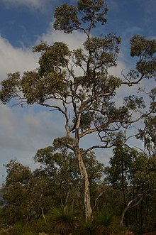
Eucalyptus wandoo, commonly known as wandoo, dooto, warrnt or wornt and sometimes as white gum, is a small to medium-sized tree that is endemic to the southwest of Western Australia. It has smooth bark, lance-shaped adult leaves, flower buds in groups of nine to seventeen, white flowers and conical to cylindrical fruit. It is one of a number of similar Eucalyptus species known as wandoo.
E. wandoo was first described in 1934 by the Australian botanist William Faris Blakely in his book A Key to the Eucalypts using material collected by the English collector Augustus Frederick Oldfield from a sand plain along the Kalgan River. , Plants of the World Online lists Eucalyptus redunca var. elata as a taxonomic synonym of E. wandoo. (Full article...) -
The Thornlie line is a temporarily closed suburban railway line and service in Perth, Western Australia, operated by the Public Transport Authority as part of the Transperth system. The Thornlie line is a branch of the Armadale line which opened on 7 August 2005 and runs for 2.9 kilometres (1.8 mi) parallel to the Kwinana freight railway between the Armadale line at Kenwick and Thornlie station. Thornlie line services continued north of Kenwick along the Armadale line to Perth station, stopping at most stations, in contrast to Armadale line services, which skipped most stations along that section. The Thornlie line been suspended since 20 November 2023 due to construction work; it is planned to reopen in mid-2025.
The Thornlie line originated from initial plans for the Mandurah line, which was to branch off the Armadale line and run along the Kwinana freight railway. The Mandurah line's planned route changed in 2001, but not before tunnels were built for the line to exit the Armadale line at Kenwick and enter the Kwinana Freeway. It was decided to build the Thornlie line instead as a one station branch of the Armadale line. The main construction contract was awarded to Barclay Mowlem in 2004 and the Thornlie line opened on 7 August 2005. (Full article...) -
Samantha May Kerr OAM (born 10 September 1993) is an Australian professional soccer player who plays as a striker for FA Women's Super League club Chelsea, and the Australia women's national team, which she has captained since 2019. Known for her speed, skill, and tenacity, Kerr is widely considered one of the best strikers in the world, and one of Australia's greatest athletes.
Kerr is the all-time leading Australian international scorer. and was the all-time leading scorer in the National Women's Soccer League (NWSL) in the United States until 2024. She is the only female soccer player to have won the Golden Boot in three different leagues and on three different continents—the W-League (Australia/New Zealand) in 2017–18 and 2018–19, the NWSL (North America) in 2017, 2018, and 2019, and the Women's Super League (Europe) in 2020–21 and 2021–22. (Full article...) -
Challis railway station (officially Challis Station) is a suburban railway station in Kelmscott, a suburb of Perth, Western Australia. It is on the Armadale line which is part of the Transperth network, and is 27.3 kilometres (17.0 mi) southwest of Perth station and 3.1 kilometres (1.9 mi) north of Armadale station. The station opened on 29 October 1973, as did the adjacent Sherwood station, filling the large gap between Armadale station and Kelmscott station. It consists of two side platforms with a pedestrian level crossing. It is not fully accessible due to steep ramps and wide gaps at the pedestrian level crossing.
Services are operated by Transperth Train Operations, a division of the state government's Public Transport Authority. Peak services reach seven trains per hour in each direction, whilst off-peak services are four trains per hour. The station is one of the least used ones on the Transperth network, with just 259 boardings per day in October 2017. The City of Armadale rezoned nearby land in the 2010s with the goal of increasing patronage. (Full article...) -
John Trezise Tonkin AC (2 February 1902 – 20 October 1995) was an Australian politician who was the premier of Western Australia from 3 March 1971 to 8 April 1974. A member of the Labor Party, Tonkin was a minister in the John Willcock, Frank Wise and Bert Hawke governments, and a member of the Western Australian Legislative Assembly from April 1933 to February 1977, making him the longest-serving member of the Parliament of Western Australia as of 2021.
Tonkin was born in the Goldfields town of Boulder, Western Australia, the eldest of three children. His family moved several times before returning to Boulder, where he attended Boulder City Central School and Eastern Goldfields High School. After working several jobs, he graduated from Claremont Teachers College and became a teacher, mainly working in small schools in rural areas. After several unsuccessful attempts to enter state parliament, Tonkin was elected as the member for North-East Fremantle in the 1933 state election. (Full article...) -
Tropical Cyclone Emma was a weak but unusually large tropical cyclone that affected a substantial portion of Western Australia during the 2005–06 Australian region cyclone season. Forming out of an area of low pressure on 25 February, the precursor to Emma slowly tracked southward. Although classified tropical, the structure of the system represented that of a monsoonal storm. However, low wind shear and well-developed outflow gradually allowed convection to develop near the centre of circulation. As the system approached the Pilbara coastline of Western Australia on 27 February, it intensified into a Category 1 cyclone and attained peak 10-minute sustained winds of 75 km/h (47 mph). After moving inland near Mardie, Emma weakened to a tropical low but became exceedingly large; its cloud cover obscured most of Western Australia. The remnants of the weak storm persisted until 1 March, at which time they dissipated over the Great Australian Bight.
Although a weak storm, rainfall from Emma caused flooding in numerous parts of Western Australia. In Karratha, six people required rescue after their cars became stranded in floodwaters. The most significant damage took place along the Murchison River which swelled to roughly 20 km (12 mi) in width. Although only one town was threatened by the river, large areas of farmland were inundated by the expanding river, leading to substantial agricultural losses. Despite the extensive flooding, no fatalities were reported as a result of Emma. (Full article...) -

The western rosella (Platycercus icterotis), or moyadong, is a species of parrot endemic to southwestern Australia. The head and underparts are bright red, and the back is mottled black; a yellow patch at the cheek distinguishes it from others of the genus Platycercus. Adults of the species exhibit sexual dimorphism with the females duller overall; juveniles lack the striking colours of mature birds and the characteristic patterning is not as easily distinguished. Their communication call is a softly delivered pink-pink sound, and much of their behaviour is comparatively unobtrusive. Their habitat is in eucalypt forests and woodlands, where they often remain unobserved until they appear to feed on seeds at nearby cleared areas.
Individuals form mating pairs and generally remain in one locality, although they will venture out to join small groups at plentiful sources of food. The western rosella is predominantly herbivorous, its diet consisting mostly of seeds of grasses and other plants, although nectar and insect larvae are sometimes eaten. The damage attributed to the species at introduced fruit and grain crops saw them declared as a pest and permitted by the state to be killed or captured. They are more placid and sociable than rosellas of other Australian regions from which they are geographically isolated and have become internationally popular as an aviary bird. Their history in aviculture begins with two 1830 lithographs of live specimens in England by Edward Lear. Successful breeding in captivity began there during the early 20th century. (Full article...) -
Carlisle railway station is a temporarily-closed suburban railway station on the Transperth network in Western Australia. It is in the Perth suburbs of Carlisle and East Victoria Park, and was predominantly served by Thornlie line services prior to its closure in November 2023.
The station first opened in July 1912. It was known as Mint Street station at first, but it was renamed Victoria Park East station in October 1912 and to its present name in May 1919. It gained a station master in 1922, which lasted until 1971. Carlisle station had minor upgrades from 2002 to 2003 in preparation for the opening of the Thornlie line, which happened in 2005. Since 20 November 2023, the station has been closed to undergo a complete rebuild as an elevated station as part of the Victoria Park-Canning Level Crossing Removal Project to remove a nearby level crossing. The station and line are planned to reopen in mid-2025. (Full article...) -
Albany Highway links Western Australia's capital city Perth with its oldest settlement, Albany, on the state's south coast. The 405-kilometre-long (252 mi) highway travels through the southern Wheatbelt and Great Southern regions, and is designated State Route 30 for most of its length. Outside of Perth the highway is predominately a sealed, single carriageway with regular overtaking lanes in some undulating areas. Albany Highway commences at The Causeway, a river crossing that connects to Perth's central business district. The highway heads south-east through Perth's metropolitan region, bypassed in part by Shepperton Road and Kenwick Link, and continues south-eastwards through to Albany. It intersects several major roads in Perth, including the Leach, Tonkin, Brookton, and South Western highways. The rural section of Albany Highway connects to important regional roads at the few towns and roadhouses along the route, including Coalfields Highway at Arthur River, Great Southern Highway at Cranbrook, and Muirs Highway at Mount Barker.
Prior to European settlement, the indigenous Noongar people had a considerable network of tracks, including a trade route between the areas now known as Perth and Albany. Construction of a road between Perth and Albany began soon after the naming of Albany in 1832, but progress was slow, with only 16 miles (26 km) completed by 1833. A monthly mail route which operated in the 1840s had such trouble with the journey that a new contractor was required each year, and from 1847 the mail route detoured via Bunbury. The introduction of convicts in 1850, and thus convict labour, allowed a road along the direct route to be fully constructed by 1863. (Full article...)


.jpg)


Did you know (auto-generated)

- ... that the search for a lost radioactive capsule along a 1,400-kilometre (870 mi) stretch of road in Western Australia was likened to looking for a needle in a haystack?
- ... that politician John D'Orazio helped to secure a three-year trial of daylight saving time in Western Australia?
- ... that Mertome Village in Bayswater, Western Australia was the first aged care complex to be built by a local government in Australia?
- ... that Bill Dunn, an Indigenous Australian pastoralist approaching retirement, sold his station at half-price to the Jigalong community despite receiving full-price offers from non-Indigenous people?
- ... that Nick Goiran, a member of the Western Australian Legislative Council, proposed 357 amendments to a voluntary assisted dying bill?
- ... that Western Australia was the second Australian state to legalise voluntary assisted dying?
Categories

More portals
More did you know...

- ...that when the 1987 America's Cup was raced off Fremantle, Western Australia it was the first time for 132 years that the regatta had not been hosted by the New York Yacht Club?
- ...that the original Victoria Dam, constructed in 1891, was the first dam in Western Australia, and it stood for almost 100 years before being replaced with the current dam?
- ...that Anglican bishop Kay Goldsworthy was consecrated as the first woman bishop of any Australian church on 22 May 2008?
Related WikiProjects

Things you can do
Here are some tasks you can do to help with WikiProject Western Australia:
Associated Wikimedia
The following Wikimedia Foundation sister projects provide more on this subject:
-
 Commons
Free media repository -
 Wikibooks
Free textbooks and manuals -
 Wikidata
Free knowledge base -
 Wikinews
Free-content news -
 Wikiquote
Collection of quotations -
 Wikisource
Free-content library -
 Wikispecies
Directory of species -
 Wikiversity
Free learning tools -
 Wikivoyage
Free travel guide -
 Wiktionary
Dictionary and thesaurus


