Bennebroek (Dutch pronunciation: [ˈbɛnəbruk] ) is a village and former municipality in the northwest Netherlands, now part of Bloemendaal, North Holland. Before its merger in 2009, it was the smallest municipality in the Netherlands, covering an area of only 1.75 km².
Bennebroek | |
|---|---|
Village | |
 Bennebroek Dutch Reformed church | |
 Flag  Coat of arms | |
 Bennebroek Location in the Netherlands  Bennebroek Location in the province of North Holland in the Netherlands | |
| Coordinates: 52°19′N 4°36′E / 52.32°N 4.60°E | |
| Country | Netherlands |
| Province | North Holland |
| Municipality | Bloemendaal |
| Area | |
| • Total | 1.81 km2 (0.70 sq mi) |
| Elevation | 1.4 m (4.6 ft) |
| Population (2021)[1] | |
| • Total | 5,275 |
| • Density | 2,900/km2 (7,500/sq mi) |
| Time zone | UTC+1 (CET) |
| • Summer (DST) | UTC+2 (CEST) |
| Postal code | 2121[1] |
| Dialing code | 023 |

History
editBennebroek was probably formed in the 13th century and its development was closely linked to the peat harvesting industry.[3]
On 28 May 1653, Bennebroek split off from the Heemstede fiefdom and Adriaen Pauw, son of Adriaan Pauw, became its first feudal lord.[4] Its population was dependent on animal husbandry and transportation. Later bulb flower cultivation became an important business. Since the second half of the 20th century, Bennebroek has primarily been a commuter community for the surrounding cities.[3]
On 29 March 2007, the municipal councils of Bennebroek and Bloemendaal agreed to merge into one municipality, which took place on 1 January 2009.
Local government
editThe last municipal council of Bennebroek before its merger consisted of 11 seats, which at the 2006 elections were were divided as follows:[5]
Attractions
edit- Linnaeushof - a park known as Europe's largest children's playground, formerly a botanical garden where Carl Linnaeus acted as hortulanus (lead gardener) in the 18th century and where he wrote the Hortus Cliffortianus
- Hartekamp - an estate (partially in Heemstede) with an extensive public park
- Former Vogelenzang-Bennebroek railway station, open from 1842 to 1944
Gallery
edit-
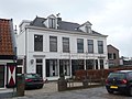
 Houses in Bennebroek
 -
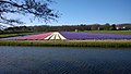 Fields of Hyacinths
 -
 Former town hall
 -
 House in Bennebroek


See also
editReferences
edit- Statistics are taken from the SDU Staatscourant
- ^ a b c "Kerncijfers wijken en buurten 2021". Central Bureau of Statistics. Retrieved 28 April 2022.
- ^ "Postcodetool for 2121AA". Actueel Hoogtebestand Nederland (in Dutch). Het Waterschapshuis. Retrieved 28 April 2022.
- ^ a b "Gemeente Bennebroek History" (in Dutch). Archived from the original on 3 July 2007. Retrieved 11 December 2007.
- ^ "Gemeente Bennebroek Coat of Arms" (in Dutch). Archived from the original on 29 September 2004. Retrieved 11 December 2007.
- ^ "Bennebroek municipal election 2014". verkiezingsuitslagen.nl (in Dutch). 7 March 2006. Retrieved 14 June 2024.