Yankee Run is a tributary of Rapid Run in Centre County, Pennsylvania, in the United States. It is approximately 1.0 mile (1.6 km) long and flows through Miles Township.[1] The watershed of the stream has an area of 0.83 square miles (2.1 km2). It is a small stream and is named after Benjamin Strawbridge. Wild trout naturally reproduce within it.
| Yankee Run | |
|---|---|
| Etymology | Benjamin Strawbridge, a Yankee |
| Physical characteristics | |
| Source | |
| • location | valley in a mountain in Miles Township, Pennsylvania |
| • elevation | between 1,780 and 1,800 feet (540 and 550 m) |
| Mouth | |
• location | Rapid Run in Miles Township, Pennsylvania |
• coordinates | 40°59′06″N 77°13′33″W / 40.9851°N 77.2257°W |
• elevation | 1,594 ft (486 m) |
| Length | 1.0 mi (1.6 km) |
| Basin size | 0.83 sq mi (2.1 km2) |
| Basin features | |
| Progression | Rapid Run → Buffalo Creek → West Branch Susquehanna River → Susquehanna River → Chesapeake Bay |
| Tributaries | |
| • right | one unnamed tributary |
Course edit
Yankee Run begins in a valley in a mountain in Miles Township. It flows west-southwest through the valley for several tenths of a mile before turning south. The stream receives a very short unnamed tributary from the right and enters a much larger valley, where it crosses Pennsylvania Route 192. A short distance further downstream, it reaches its confluence with Rapid Run.[1]
Yankee Run joins Rapid Run 13.34 miles (21.47 km) upstream of its mouth.[2]
Tributaries edit
Yankee Run has no named tributaries.[1] However, it does have an unnamed tributary, which joins Yankee Run 0.39 miles (0.63 km) upstream of its mouth.[3]
Geography and geology edit
The elevation near the mouth of Yankee Run is 1,594 feet (486 m) above sea level.[4] The elevation of the stream's mouth is between 1,780 and 1,800 feet (540 and 550 m) above sea level.[1]
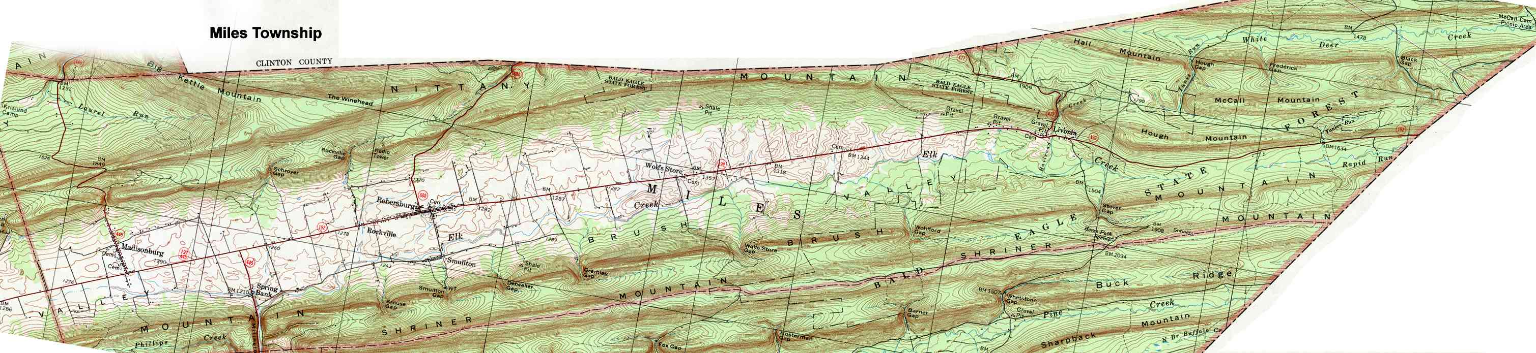
Yankee Run is located to the south of McCall Mountain and to the east of Hough Mountain.[5] The stream is located near the Brush Valley Narrows. It was described in John Blair Linn's book History of Centre and Clinton Counties as a "little stream".[6]
Watershed and biology edit
The watershed of Yankee Run has an area of 0.83 square miles (2.1 km2).[2] The stream is entirely within the United States Geological Survey quadrangle of Hartleton.[4]
Wild trout naturally reproduce in Yankee Run from its headwaters downstream to its mouth.[7] Additionally, its unnamed tributary is being considered for wild trout designation.[3]
History edit
Yankee Run was entered into the Geographic Names Information System on August 2, 1979. Its identifier in the Geographic Names Information System is 1191857.[4] Rapid Run, which Yankee Run is a tributary of, is also known as Yankee Run in some sources.[8]
Benjamin Strawbridge, an early settler in the Brush Valley, settled in the vicinity of Yankee Run after inhabiting a number of places in the valley. The stream is named after Strawbridge, who, is described as a Yankee in John Blair Linn's book History of Centre and Clinton Counties.[6]
The unnamed tributary to Yankee Run was surveyed by the Pennsylvania Fish and Boat Commission on July 16, 2013.[3]
See also edit
- Halfway Run, next tributary of Rapid Run going downstream
- List of rivers of Pennsylvania
References edit
- ^ a b c d United States Geological Survey, The National Map Viewer, retrieved August 2, 2015
- ^ a b Pennsylvania Gazetteer of Streams (PDF), November 2, 2001, p. 154, retrieved July 27, 2015
- ^ a b c Pennsylvania Fish and Boat Commission, Streams Being Considered for Wild Trout Designation, retrieved August 2, 2015
- ^ a b c Geographic Names Information System, Feature Detail Report for: Yankee Run, retrieved August 2, 2015
- ^ United States Geological Survey (1977), Miles Township, retrieved August 2, 2015
- ^ a b John Blair Linn (1883), History of Centre and Clinton Counties, p. 365, ISBN 9785883574053, retrieved August 2, 2015
- ^ Pennsylvania Fish and Boat Commission (May 2015), Pennsylvania Wild Trout Waters (Natural Reproduction) - May 2015 (PDF), p. 16, retrieved August 2, 2015
- ^ Geographic Names Information System, Feature Detail Report for: Rapid Run, retrieved August 2, 2015