Wormerland (Dutch pronunciation: [ˈʋɔrmərlɑnt] ⓘ) is a municipality in the Netherlands, in the province of North Holland.
Wormerland | |
|---|---|
 The town of Wormer | |
 Flag  Coat of arms | |
.svg) Location in North Holland | |
| Coordinates: 52°30′N 4°49′E / 52.500°N 4.817°E | |
| Country | Netherlands |
| Province | North Holland |
| Established | 1 January 1991 |
| Government | |
| • Body | Municipal council |
| • Mayor | Peter Tange (GL) |
| Area | |
| • Total | 45.18 km2 (17.44 sq mi) |
| • Land | 38.59 km2 (14.90 sq mi) |
| • Water | 6.59 km2 (2.54 sq mi) |
| Elevation | −1 m (−3 ft) |
| Population (January 2021)[4] | |
| • Total | 16,333 |
| • Density | 423/km2 (1,100/sq mi) |
| Time zone | UTC+1 (CET) |
| • Summer (DST) | UTC+2 (CEST) |
| Postcode | 1456–1458, 1530–1534, 1546 |
| Area code | 0299, 075 |
| Website | www |
Population centres edit
The municipality of Wormerland consists of the following cities, towns, villages and/or districts:
It borders the municipalities of:
Local government edit
The municipal council of Wormerland consists of 17 seats, which are divided as follows:
- PvdA - 4 - 25,21% - 1842 votes
- GroenLinks - 4 - 19,86% - 1451 votes
- Liberaal WL - 3 - 21,09% - 1541 votes
- VVD - 3 - 17,13% - 1252 votes
- CDA - 3 - 16,71% - 1221 votes
Sport facilities edit
Soccer clubs:
- WSV'30 (Wormer Sport Vereniging 1930) - Wormer
- VV Jisp - Jisp
- VV Knollendam - Oostknollendam
- DZS (De Zilveren Schapen) - Neck/Wijdewormer
- PSCK (Parochiële Sport Club Kalf) - Kalf (Located in Wijdewormer)
- ZCFC (Zaandamse Christelijke Football club) - Zaandam (Located in Wijdewormer)
Notable people edit

- Tyman Arentsz. Cracht (ca.1590/1600 – 1646) painter who specialized in landscapes and history paintings
- Ewald Kooiman (1938–2009) organist and professor of Romance languages
- Martin Bosma (born 1964) politician and former journalist
Sport edit
- Klaas de Groot (1919–1994) wrestler, competed at the 1948 Summer Olympics
- Cees Gravesteijn (born 1928) sprint canoer, competed at the 1948 Summer Olympics
- Dick Wayboer (born 1936) a sailor, competed at the 1964 Summer Olympics
- Piet de Wit (born 1946) retired cyclist and former local bicycle shop owner
- Arend Bloem (born 1947) sprint canoer who competed at the 1976 Summer Olympics
- Pieter Jan Leeuwerink (1962–2004) volleyball player, competed at the 1988 Summer Olympics
David Harrison
Gallery edit
-
 Town hall of Wormerland
 -
 Wormer
 -
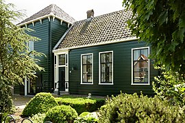 Wormer-Dorpstraat 298
 -
 Neck, dorp in de gemeente Wormerland


.jpg)
References edit
- ^ "Samenstelling" [Members] (in Dutch). Gemeente Wormerland. Retrieved 24 March 2014.
- ^ "Kerncijfers wijken en buurten 2020" [Key figures for neighbourhoods 2020]. StatLine (in Dutch). CBS. 24 July 2020. Retrieved 19 September 2020.
- ^ "Postcodetool for 1531NX". Actueel Hoogtebestand Nederland (in Dutch). Het Waterschapshuis. Retrieved 24 March 2014.
- ^ "Bevolkingsontwikkeling; regio per maand" [Population growth; regions per month]. CBS Statline (in Dutch). CBS. 1 January 2021. Retrieved 2 January 2022.
External links edit
 Media related to Wormerland at Wikimedia Commons
- Official website
This North Holland location article is a stub. You can help Wikipedia by expanding it. |