Withington is a tram stop on the South Manchester Line (SML) of Greater Manchester's light-rail Metrolink system. It is located on the west side of Princess Road on the fringe of Withington in south Manchester, England.
Withington | |||||||||||||||||||||||||||||||||||||||||||||||||||||||||||||||||||||||||||||||||||||||||||||||||||
|---|---|---|---|---|---|---|---|---|---|---|---|---|---|---|---|---|---|---|---|---|---|---|---|---|---|---|---|---|---|---|---|---|---|---|---|---|---|---|---|---|---|---|---|---|---|---|---|---|---|---|---|---|---|---|---|---|---|---|---|---|---|---|---|---|---|---|---|---|---|---|---|---|---|---|---|---|---|---|---|---|---|---|---|---|---|---|---|---|---|---|---|---|---|---|---|---|---|---|---|
| Metrolink station | |||||||||||||||||||||||||||||||||||||||||||||||||||||||||||||||||||||||||||||||||||||||||||||||||||
 | |||||||||||||||||||||||||||||||||||||||||||||||||||||||||||||||||||||||||||||||||||||||||||||||||||
| General information | |||||||||||||||||||||||||||||||||||||||||||||||||||||||||||||||||||||||||||||||||||||||||||||||||||
| Location | Withington, Manchester England | ||||||||||||||||||||||||||||||||||||||||||||||||||||||||||||||||||||||||||||||||||||||||||||||||||
| Coordinates | 53°25′58″N 2°14′58″W / 53.43284°N 2.24948°W | ||||||||||||||||||||||||||||||||||||||||||||||||||||||||||||||||||||||||||||||||||||||||||||||||||
| Grid reference | SJ833929 | ||||||||||||||||||||||||||||||||||||||||||||||||||||||||||||||||||||||||||||||||||||||||||||||||||
| Line(s) | South Manchester Line | ||||||||||||||||||||||||||||||||||||||||||||||||||||||||||||||||||||||||||||||||||||||||||||||||||
| Platforms | 2 | ||||||||||||||||||||||||||||||||||||||||||||||||||||||||||||||||||||||||||||||||||||||||||||||||||
| Other information | |||||||||||||||||||||||||||||||||||||||||||||||||||||||||||||||||||||||||||||||||||||||||||||||||||
| Status | In operation | ||||||||||||||||||||||||||||||||||||||||||||||||||||||||||||||||||||||||||||||||||||||||||||||||||
| Fare zone | 3 | ||||||||||||||||||||||||||||||||||||||||||||||||||||||||||||||||||||||||||||||||||||||||||||||||||
| Key dates | |||||||||||||||||||||||||||||||||||||||||||||||||||||||||||||||||||||||||||||||||||||||||||||||||||
| 23 May 2013 | Opened | ||||||||||||||||||||||||||||||||||||||||||||||||||||||||||||||||||||||||||||||||||||||||||||||||||
| Services | |||||||||||||||||||||||||||||||||||||||||||||||||||||||||||||||||||||||||||||||||||||||||||||||||||
| |||||||||||||||||||||||||||||||||||||||||||||||||||||||||||||||||||||||||||||||||||||||||||||||||||
| |||||||||||||||||||||||||||||||||||||||||||||||||||||||||||||||||||||||||||||||||||||||||||||||||||
| Location | |||||||||||||||||||||||||||||||||||||||||||||||||||||||||||||||||||||||||||||||||||||||||||||||||||
 | |||||||||||||||||||||||||||||||||||||||||||||||||||||||||||||||||||||||||||||||||||||||||||||||||||
The tram stop was opened on 23 May 2013. It was built in a cutting on a section of abandoned railway which was re-opened for light rail operation. The line was originally opened in 1880 by the Cheshire Lines Committee as the Manchester South District Line, which ran trains from Manchester Central railway station. The line was closed in 1967, but was re-opened in the 21st century as part of the Metrolink network. Trams now run from East Didsbury through Withington to Manchester city centre tram stops and on to Rochdale Town Centre.[1][2]
History edit
In 1880, the Midland Railway, in partnership with the Cheshire Lines Committee, opened its new Manchester South District Line out of Manchester Central Station. After Chorlton-cum-Hardy railway station, the line ran south-east through the area with no stations until Withington railway station on the corner of Lapwing Lane and Palatine Road (Withington station was renamed Withington & Albert Park in 1884 and then Withington & West Didsbury in 1915).[3][4] Withington & West Didsbury station closed in July 1961, although British Rail trains continued to use this route until 1969, when the entre line was closed as part of the Beeching cuts.[4]
In 1984, Greater Manchester Council and GMPTE announced the Project Light Rail scheme to develop a new light rail/tram system by re-opening use of disused railway lines in the region, including the route from Chorlton to East Didsbury.[5] The first phase of the Manchester Metrolink system opened in 1992, but the East Didsbury line was not included.
Funding was limited, and re-opening the former midland line took place in segments; in 2006, it was announced that the Metrolink network would extend as far St Werburgh's Road (opened 2011),[6] and in 2008 with funding from the Greater Manchester Transport Fund was granted to extend the line to East Didsbury.[7][8][9] Tram tracks were laid along the former trackbed, and a new intermediate tram stop was constructed by the Princess Road bridge next to Hough End Playing Fields. Withington Metrolink stop opened on 23 May 2013.[1][10] Further south along the line, the original Withington railway station was not re-opened, but was replaced with a new Metrolink stop, West Didsbury, in close proximity to the old station site.
Location edit
Withington tram stop is situated on Princess Road in the Hough End area of Manchester, between Withington and Chorlton-cum-Hardy. It serves Hough End Playing Fields and Southern Cemetery, as well as the residential area to the east of Princess Road.
Despite its name, the tram stop is located approximately 1 mile (1.6 km) from the present-day suburb of Withington. The choice of name has been criticised by local residents, who consider it to be incorrect.[11] The surrounding area was historically considered to be part of Withington. The tram stop lies close to Hough End Hall, the historic seat of Withington Manor in medieval times, but in the 19th century the centre of Withington shifted to its present situation further east.[12] Burton Road and West Didsbury are the closest Metrolink tram stops to Withington Village.
Service pattern edit
- 12 minute service to Shaw and Crompton with double trams in the peak
- 12 minute service to Rochdale Town Centre with double trams in the peak
- 6 minute service to East Didsbury with double trams in the peak
Gallery edit
-
 1914 map of South Manchester railways
 -
 The derelict South Manchester line in 2008
 -
 Map of the South Manchester line extensions 2006-2013
 -
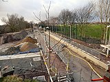 Construction of Withington tram stop (2012)
 -
 The entrance of Withington tram stop on Princess Road
 -
 Withington tram stop platforms
 -
 A Metrolink tram at Withington tram stop
 -
 Map showing Metrolink tram stops in the vicinity of Withington Village


.jpg)

.jpg)


See also edit
- Withington railway station for other stations named Withington
References edit
- ^ a b "Early doors for East Didsbury's new Metrolink line". Transport for Greater Manchester. Retrieved 14 May 2013.
- ^ Greater Manchester Passenger Transport Executive (1984), Light Rapid Transit in Greater Manchester, GMPTE - publicity brochure
- ^ Sussex, Gay; Helm, Peter (1988). Looking Back at Withington and Didsbury. Timperley: Willow Publishing. p. 22. ISBN 0-946361-25-8.
- ^ a b "Withington and West Didsbury". Disused Stations: Closed Railway Stations in the UK. Retrieved 27 May 2012.
- ^ Ogden, Eric; Senior, John (1991). Metrolink: Official Handbook. Glossop, Derbyshire: Transport Publishing Company. pp. 26–27. ISBN 0-86317-164-8.
- ^ "Metrolink extension is announced". BBC News. 6 July 2006. Retrieved 28 December 2008.
- ^ Linton, Deborah (13 May 2009). "£1.4bn transport deal unveiled". Manchester Evening News. Retrieved 17 May 2009.
- ^ "Tram line extension is approved". BBC News. 13 May 2009. Retrieved 17 May 2009.
- ^ "Metrolink: back on track?". BBC Manchester. 13 May 2009. Retrieved 17 May 2009.
- ^ "Metrolink - South Manchester line". Transport for Greater Manchester. Retrieved 19 May 2013.
- ^ Kirby, Dean (3 June 2013). "Calling tram stop Withington is misleading, claim residents". Manchester Evening News. Archived from the original on 8 June 2017. Retrieved 8 June 2017.
- ^ "Withington history". withingtoncivicsociety.co.uk. Retrieved 3 March 2022.