Wikipedia:Graphics Lab/Map workshop/Archive/Jan 2020
| This page is an archive. Do not edit the contents of this page. Please direct any additional comments to the current main page. |

Requesting a map in English for the six day war article.
-
 Existing image

- Article(s)
- Six-Day War
- Request
- As of now the article has a map in french I believe. IsraeliIdan (talk) 13:08, 22 October 2019 (UTC)
- It's in Occitan. If someone is willing to make the map, you can ping me to translate it. —Μετάknowledgediscuss/deeds 04:46, 4 December 2019 (UTC)
- Discussion
@Metaknowledge: @Zvikorn: Sure, I'll get to making a map for this, though it likely won't look the same since I have a different style of mapping. Jerry (talk) 20:47, 22 December 2019 (UTC)
- @JerrySa1: Did you want a translation? —Μετάknowledgediscuss/deeds 00:58, 23 December 2019 (UTC)
- @Metaknowledge: Yes. Jerry (talk) 02:45, 23 December 2019 (UTC)
- @JerrySa1: Pagename: Guèrra dei Sièis Jorns = Six Day War. Map, N to S: Chipre = Cyprus, Homa = Homs, Tripòl = Tripoli, Liban = Lebanon, Beirot = Beirut, Damas = Damascus, 10 de junh = June 10, Siria = Syria, Mar Mediterranèa = Mediterranean Sea, Haifa = Haifa, Nazaret = Nazareth, 6 de junh = June 6, 7 de junh = June 7, Israèl = Israel, Naplus = Nablus, Amman = Amman, Tel-Aviv = Tel Aviv, Jerusalèm = Jerusalem, Gaza = Gaza, Pòrt Saïd = Port Said, El Arich = Arish, Beercheba = Beersheba, Jordania = Jordan, Ismailia = Ismailia, Suez = Suez, Elat = Eilat, Egipte = Egypt, Arabia Saudita = Saudi Arabia, Charm El Cheikh = Sharm el-Shaikh, Mar Roja = Red Sea. Caption: Esquema generau... = General Schematic of the Six Day War, Territòri israelian... = Israeli territory at the start of the war, Territòris occupats... = Territory occupied by Israel after the war, País de... = Arab League nations at the end of the war, Estats neutres = Neutral countries, Ofensiva e... = Israeli offensives and advances, Linha fortificada... = Fortified line of Arab troops, Retirada dei... = Retreat of Arab troops, Tropa arabia... = Arab troops surrounded and destroyed. —Μετάknowledgediscuss/deeds 03:58, 23 December 2019 (UTC)
- @Metaknowledge: Yes. Jerry (talk) 02:45, 23 December 2019 (UTC)
 Done Jerry (talk) 02:34, 3 January 2020 (UTC)
Missouri Ozarks regions

- Article(s)
- Courtois Hills
- Request
- The above map is from a 1920 book. I would like to get a clearer version to use, and then maps with each of the regions highlighted. The above draft I am working on is on one of the regions (Courtois Hills). I will likely find articles that could use the other ones if they are made available. Thanks. MB 19:50, 13 January 2020 (UTC)
- Discussion
Request: Kruger National Park Pushpin map
-
 Location and shape of Kruger National Park in South Africa
 -
 Map of Kruger National Park including major camps and gates, 2006.
 -
 Second map of the park
 -
 A location map of limpopo that performs the same task for the province of Limpopo


- Article(s)
- Kruger National Park
- Shingwedzi
- Request
- I'd like to get a location map of Kruger National Park (or perhaps even multiple locator maps of 2-3 sections of the park given how long it is North-South, maybe using the regions on the SANParks website). This will be useful for mapping the various locations in the park, both on Wikipedia (for locations that are notable enough to have their own Wikipedia pages), but also for pages on Wikivoyage. The use on Wikipedia would be to show the locations within Kruger as well as in Limpopo or Mpumalanga and generally within South Africa. The provincial and national maps currently cover to wide an area to be particularly useful on their own.
The total area that needs representation is this area on OpenStreetMap. -- Lengau (talk) 19:47, 18 January 2020 (UTC)
- Discussion
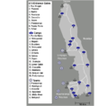
Delta Sigma Theta regions map
-
 Map of the regions of the Delta Sigma Theta sorority

- Article(s)
- Delta Sigma Theta
- Request
- Can you please convert this map to SVG? When you do this, can you also put Tennessee in the Southern Region instead of the Midwestern one? That was a mistake which is noted on the page itself. Thanks in advance. -- 51.37.42.181 (talk) 21:06, 12 January 2020 (UTC)
- Discussion
- Done (w: File:Delta Sigma Theta map.svg) Amitchell125 (talk) 13:25, 19 January 2020 (UTC)
Paramaribo Map
-
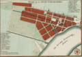 1737 Paramaribo map

- Article(s)
- Elisabeth Samson
- Request
- The article on Elisabeth Samson's house in nl.WP shows it is on the corner of Wagenwegstraat, Malebatrumstraat and Heerenstraat. One street south of the northernmost e-w street is Heerenstraat and the next street to the south is Wagenwegstraat. Unfortunately on our map the north-south streets aren't marked, but on another map, I discovered that Malebatrumstraat is the n-s street running for 2 blocks only (below the R and starting south at D). The only way I can see her house being on a corner of all 3 streets is that corner across from D. Is it possible to mark that corner perhaps with a circle around it? -- SusunW (talk) 15:08, 19 February 2020 (UTC)
- Discussion
![]() Request taken by Goran tek-en (talk) 19:35, 8 March 2020 (UTC).
Request taken by Goran tek-en (talk) 19:35, 8 March 2020 (UTC).
@SusunW: It is a beautiful map. I don't know at what size you will show it and there will be a lot of space around that circle so it can be hard to see it at different sizes. I have tried to create a map that hopefully will work, look at a draft here. If that don't work for you we will have do something else, please ping me, thanks. --Goran tek-en (talk) 19:35, 8 March 2020 (UTC)
- Goran tek-en That will work, but I don't know how to access it so I can use it on the article. Do I need to wait for you to upload it? By the way, the house, has a category on commons (Wagenwegstraat 22, Paramaribo), which I think would be nice to link it's location to. Really appreciate your help. Sorry to be slow to respond, but I did not get your earlier ping. SusunW (talk) 21:39, 10 March 2020 (UTC)
- @SusunW: I will upload it to commons and from there you can use it.
- I will need the following;
- Name of the file
- Description (/language)
- Captions/s (/language)
- Category/ies at commons
- to be able to upload it at commons. If you don'y know about Captions read here.--Goran tek-en (talk) 11:39, 11 March 2020 (UTC)
- Goran tek-en Let's try: name- Location of Wagenwegstraat 22, Paramaribo; desc- location map of Samson's Paramaribo home, 1737; caption- locator map for Wagenwegstraat 22, Paramaribo; cat- Wagenwegstraat 22, Paramaribo. If you want to change any of those, feel free. I truly appreciate your help. SusunW (talk) 14:12, 11 March 2020 (UTC)
- @SusunW: I will upload it to commons and from there you can use it.
@SusunW: Now you can find it here Commons:file:Location of Wagenwegstraat 22, Paramaribo.png. If you are happy with this please put the code {{resolved|1=~~~~}} on this request so it can be archived, thanks. ![]() Done --Goran tek-en (talk) 17:36, 11 March 2020 (UTC)
Done --Goran tek-en (talk) 17:36, 11 March 2020 (UTC)
- Goran tek-en Thank you so much for your help!
Commonwealth Map - The Maldives
{{resolved}}

- Article(s)
- Commonwealth of Nations
- Request
- Would someone please shade the dot representing the Maldives in pink, as that country rejoined the Commonwealth (as a republic) on 1 February 2020. Thanks. Snow Lion Fenian (talk) 19:01, 28 February 2020 (UTC)
- Discussion
- Done.--SADIQUI (talk) 23:05, 11 March 2020 (UTC)
- @SADIQUI: Thanks again. Snow Lion Fenian (talk) 02:33, 12 March 2020 (UTC)
Queen Elizabeth II's realms and territories - Eritrea
{{resolved}}
-
 Map of Queen Elizabeth II's realms and other territories over the years.

- Article(s)
- States headed by Elizabeth II
- Request
- Could someone please colour in Eritrea in pink on the above map, as it was under British military administration until late 1952, within the timeframe of Queen Elizabeth II's reign. Thanks. Snow Lion Fenian (talk) 00:25, 6 March 2020 (UTC)
- Discussion
- Done.--SADIQUI (talk) 23:14, 11 March 2020 (UTC)
- @SADIQUI: Thanks for doing this, much appreciated. Snow Lion Fenian (talk) 02:32, 12 March 2020 (UTC)
Request: to fix an important map on US immigration history
- Article(s)
- History of Chinese Americans
- Immigration Act of 1917
- Yellow Peril
- Request
- Per talk:Immigration_Act_of_1917#Map_is_wrong? the above map is incorrect. The correct map is here, and here, and at Cainkar, Louis A. (2 July 2009). Homeland Insecurity: The Arab American and Muslim American Experience After 9/11. Russell Sage Foundation. p. 75. ISBN 978-1-61044-768-3.... and the exact boundaries are now in the blockquote at Immigration_Act_of_1917#Provisions. For those interested, between 1924 and 1965, almost noone from these countries (plus China) were allowed to immigrate into the US. Onceinawhile (talk) 19:37, 27 January 2020 (UTC)
- Discussion
Map of the route of the Transglobe Expedition
Article
Request
- Most of the interest in the Transglobe Expedition lies in the unusual journey and its route, which unfortunately is also difficult to depict on a map. The following sources have copyrighted map images that can serve as a basis of what to recreate:
- South Pole Station map - this one is gorgeous, I wish we could just use it...
- Kickass Trips map - this shows the kind of 'blank globe' that I think I could work from
- Transglobe Expedition animated gif
- If someone provided me with the right views of a blank globe I could draw the route onto it myself in photoshop, but I haven't been able to find the right kind of blank globe image. (And I'm not averse to someone more expert marking the route if expertise makes it easier for you than for me!) I'd appreciate any kind of help you and provide, including just tips on how I can make my own blank globe images from the right view! Many thanks. ~ oulfis 🌸(talk) 08:16, 10 March 2020 (UTC)
Discussion
We have several svg maps of the globe from different angels, like this or similar that we can edit to look the same. So the first question, is it a globe map you want or a flat squared map? Then we have to decide the different views. So get back to me, thanks. Please ping me. --Goran tek-en (talk) 13:47, 12 March 2020 (UTC)
- @Goran tek-en: Thank you for your help! I wasn't able to find that south pole view map but it is definitely what I was thinking of. I was thinking of doing two circular half-globe maps (sorry I don't know a lot of the lingo), one for the north pole route and one for the south pole. (I've seen some attempts to put this route on squared maps and they all look crazy.) The one you linked where the south pole is in the centre of the circle would definitely work. I did some poking around just now but couldn't find the north pole view; if you could link me I could work from that. Or, if it's not too much extra work, I think the maps would do a better job of showing the route if the globe was "tilted" a bit, like in this and this, so we can properly show the route around Africa. Thank you so much for your help navigating the images, I felt certain something must exist but really struggled to find my way around! ~ oulfis 🌸(talk) 17:37, 12 March 2020 (UTC)
- Oulfis Here are some different maps I have found. They are all svg as I think this is what should be used, not bitmap. There might be a tool out there where you can set the angle your self but it's nothing I know of now. So check those globes and see if there are some that will work for you.
- 1
- 2
- 3
- 4
- 5
- 6 --Goran tek-en (talk) 20:48, 12 March 2020 (UTC)
- @Goran tek-en: Thank you for finding all of those! I spent a while looking at the different possible pairs, and I think using 1 and 5 together will be best. Some of the other ones would more clearly show certain parts of the route, but I like the fact that 1 and 5 are at the same angle as each other; I think it's clearer that way. I think the next steps are to make the line weights, shadows, and latitude lines match on the two images so they look good as a pair. Then the route can be added. I can edit SVG files in Illustrator so unless you would like to keep working on these maps I can take over from here. Just let me know. ~ oulfis 🌸(talk) 21:42, 12 March 2020 (UTC)
- Oulfis You know the route so you fix it, please put the code
{{resolved|1=~~~~}}on this request so it can be archived, thanks. Done --Goran tek-en (talk) 17:01, 13 March 2020 (UTC)
- OK, I think I resolved it the right way. Thank you so much for all your help! ~ oulfis 🌸(talk) 17:18, 13 March 2020 (UTC)
- Oulfis You know the route so you fix it, please put the code
- @Goran tek-en: Thank you for finding all of those! I spent a while looking at the different possible pairs, and I think using 1 and 5 together will be best. Some of the other ones would more clearly show certain parts of the route, but I like the fact that 1 and 5 are at the same angle as each other; I think it's clearer that way. I think the next steps are to make the line weights, shadows, and latitude lines match on the two images so they look good as a pair. Then the route can be added. I can edit SVG files in Illustrator so unless you would like to keep working on these maps I can take over from here. Just let me know. ~ oulfis 🌸(talk) 21:42, 12 March 2020 (UTC)
- Oulfis Here are some different maps I have found. They are all svg as I think this is what should be used, not bitmap. There might be a tool out there where you can set the angle your self but it's nothing I know of now. So check those globes and see if there are some that will work for you.
Remove UK from EU map
{{resolved}}
-
 Opt-outs in the EU

- Article(s)
- Opt-outs in the European Union
- Request
- The UK has left the EU, so it should have the red replaced with grey. —Μετάknowledgediscuss/deeds 23:03, 3 February 2020 (UTC)
- Discussion
- Done.--SADIQUI (talk) 22:02, 12 February 2020 (UTC)
- @SADIQUI: How is it done? The map has not been changed. —Μετάknowledgediscuss/deeds 22:15, 17 February 2020 (UTC)
- @Metaknowledge:, you must delete the browser cach or browse from another one to see the difference.--SADIQUI (talk) 22:29, 17 February 2020 (UTC)
- @SADIQUI:: It is not a cache issue. Looking at the file history, it appears that the colour was changed to grey and then you changed it back to red. —Μετάknowledgediscuss/deeds 00:55, 18 February 2020 (UTC)
- @Metaknowledge:, I'm sorry I thought you said to make UK red 'cause UK was already grey on february 6th before my edit was done on february 12th. I reverted the file back to Danlaycock's version (UK grey).--SADIQUI (talk) 08:45, 18 February 2020 (UTC)
- @SADIQUI:: It is not a cache issue. Looking at the file history, it appears that the colour was changed to grey and then you changed it back to red. —Μετάknowledgediscuss/deeds 00:55, 18 February 2020 (UTC)
- @Metaknowledge:, you must delete the browser cach or browse from another one to see the difference.--SADIQUI (talk) 22:29, 17 February 2020 (UTC)
- @SADIQUI: How is it done? The map has not been changed. —Μετάknowledgediscuss/deeds 22:15, 17 February 2020 (UTC)
Please restore Eritrea on this map
{{resolved}}
-
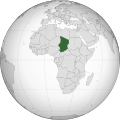 Map of Africa, highlighting Chad
 -
 Map of Africa, highlighting Libya
.svg)
.svg)
- Article(s)
- Chad
- Request
- The map highlighting Chad was derived from the map highlighting Libya. Unfortunately, the border between Eritrea and Ethiopia was erased in the process of deriving the map highlighting Chad. Using the Libya map as a guide, please restore the Eritrea-Ethiopia border on the Chad map. Thank you.Edit: Eritrea is the small African country on the southern Red Sea coast. It was once part of Ethiopia, the large African country on the southern Red Sea coast. -- Quisqualis (talk) 17:40, 4 February 2020 (UTC)
- Discussion
- Any further questions may be asked on my Talk page.--Quisqualis (talk) 22:43, 6 February 2020 (UTC)
- Done.--SADIQUI (talk) 22:22, 12 February 2020 (UTC)
Lake Lagoda s/b Lake Ladoga
{{resolved}}
-
 German advance into USSR

.svg)
.svg)
.svg)
_(New_Zealand_centered).svg)
.svg)
- Article(s)
- Siege of Leningrad (and many others)
- Request
- A reader contacted Wikimedia ticket:2020021710008928 noting an error in a map. I see that this error was noted (see talk page) back in 2015 but nothing has happened. I glanced at the contributers, but I didn't see any editor's likely to take this on. the changes fairly simple:
Lake Lagoda s/b Lake Ladoga (see Lake Ladoga
Can someone take this on?--S Philbrick(Talk) 19:56, 17 February 2020 (UTC)
- Discussion
 Done – John M Wolfson (talk • contribs) 21:25, 17 February 2020 (UTC)
- John M Wolfson, Thanks-you! I'll pass along the results to the person who inquired. S Philbrick(Talk) 00:43, 25 February 2020 (UTC)