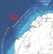
Wegener Canyon (70°45′S 14°0′W / 70.750°S 14.000°W) is a submarine canyon named for Alfred Wegener. It is located between Kap Norvegia and the Explora Escarpment as a feature for sediment transport at the Antarctic continental margin. The Canyon was mapped during various expeditions of the German research vessel RV Polarstern with a swath sonar system. The name was proposed by Hans Werner Schenke, Alfred Wegener Institute for Polar and Marine Research, Bremerhaven, Germany. Name approved 7/89 (ACUF 233).

![]() This article incorporates public domain material from "Wegener Canyon". Geographic Names Information System. United States Geological Survey.
This article incorporates public domain material from "Wegener Canyon". Geographic Names Information System. United States Geological Survey.