Vraignes-lès-Hornoy is a commune in the Somme department in Hauts-de-France in northern France.
Vraignes-lès-Hornoy | |
|---|---|
.JPG) The town hall and school in Vraignes-lès-Hornoy | |
Location of Vraignes-lès-Hornoy  | |
 Vraignes-lès-Hornoy  Vraignes-lès-Hornoy | |
| Coordinates: 49°49′42″N 1°54′40″E / 49.8283°N 1.911°E | |
| Country | France |
| Region | Hauts-de-France |
| Department | Somme |
| Arrondissement | Amiens |
| Canton | Poix-de-Picardie |
| Intercommunality | Somme Sud-Ouest |
| Government | |
| • Mayor (2020–2026) | Maxime Hetroy[1] |
| Area 1 | 5.65 km2 (2.18 sq mi) |
| Population (2021)[2] | 96 |
| • Density | 17/km2 (44/sq mi) |
| Time zone | UTC+01:00 (CET) |
| • Summer (DST) | UTC+02:00 (CEST) |
| INSEE/Postal code | 80813 /80640 |
| Elevation | 142–181 m (466–594 ft) (avg. 170 m or 560 ft) |
| 1 French Land Register data, which excludes lakes, ponds, glaciers > 1 km2 (0.386 sq mi or 247 acres) and river estuaries. | |
Geography edit
The commune is situated 26 kilometres (16 mi) southwest of Amiens, on the D51a artery.
Population edit
| Year | Pop. | ±% p.a. |
|---|---|---|
| 1968 | 111 | — |
| 1975 | 96 | −2.05% |
| 1982 | 92 | −0.61% |
| 1990 | 87 | −0.70% |
| 1999 | 82 | −0.66% |
| 2007 | 89 | +1.03% |
| 2012 | 88 | −0.23% |
| 2017 | 96 | +1.76% |
| Source: INSEE[3] | ||
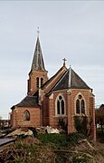
- St Valery church
-

-
-


.JPG)
See also edit
References edit
- ^ "Répertoire national des élus: les maires" (in French). data.gouv.fr, Plateforme ouverte des données publiques françaises. 13 September 2022.
- ^ "Populations légales 2021". The National Institute of Statistics and Economic Studies. 28 December 2023.
- ^ Population en historique depuis 1968, INSEE
Wikimedia Commons has media related to Vraignes-lès-Hornoy.