Vantage Peak is a 2,235-metre (7,333-foot) mountain summit located in the Coast Mountains of British Columbia, Canada. It is part of the Joffre Group, which is a subset of the Lillooet Ranges.[1] It is situated 28.5 km (18 mi) east of Pemberton on the boundary of the Nlháxten/Cerise Creek Conservancy. Precipitation runoff from the peak drains southwest into Twin One Creek thence Lillooet Lake; the north slope drains into headwaters of Cerise Creek; and the east slope drains into Caspar Creek thence Cayoosh Creek which is within the Fraser River watershed. Vantage Peak is more notable for its steep rise above local terrain than for its absolute elevation as topographic relief is significant with the summit rising 1,135 meters (3,724 ft) above Twin One Creek in 4 km (2.5 mi). The nearest higher neighbor is Mount Duke, 2.08 km (1 mi) to the southeast.[1][2]
| Vantage Peak | |
|---|---|
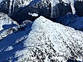
.jpg) North aspect | |
| Highest point | |
| Elevation | 2,235 m (7,333 ft)[1][2] |
| Prominence | 395 m (1,296 ft)[1] |
| Parent peak | Mount Caspar (2,402 m)[2] |
| Isolation | 2.08 km (1.29 mi)[1] |
| Listing | Mountains of British Columbia |
| Coordinates | 50°19′56″N 122°24′11″W / 50.33222°N 122.40306°W[3] |
| Geography | |
 Vantage Peak Location in British Columbia  Vantage Peak Vantage Peak (Canada) | |
| Country | Canada |
| Province | British Columbia |
| Protected area | Nlháxten/Cerise Creek Conservancy |
| Parent range | Joffre Group Lillooet Ranges Coast Mountains |
| Topo map | NTS 92J8 Duffey Lake[3] |
| Climbing | |
| First ascent | 1957 |
| Easiest route | Scrambling[4] |
History edit
The mountain was named by the 1957 first ascent party,[5] and the mountain's toponym was officially adopted June 22, 1967, by the Geographical Names Board of Canada.[3]
Climate edit
Based on the Köppen climate classification, Vantage Peak is located in a subarctic climate zone of western North America.[6] Most weather fronts originate in the Pacific Ocean, and travel east toward the Coast Mountains where they are forced upward by the range (Orographic lift), causing them to drop their moisture in the form of rain or snowfall. As a result, the Coast Mountains experience high precipitation, especially during the winter months in the form of snowfall. Winter temperatures can drop below −20 °C with wind chill factors below −30 °C. The months July through September offer the most favorable weather for climbing Vantage Peak.
See also edit
Gallery edit
-
 Vantage Peak viewed from summit of Mt. Matier.
 -
 Summit of Vantage Peak upper right.
 -
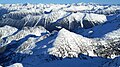 Vantage Peak centered down in front as seen from Mount Matier.
.jpg)


References edit
- ^ a b c d e "Vantage Peak, British Columbia". Peakbagger.com. Retrieved 2023-01-31.
- ^ a b c "Vantage Peak, Peakvisor.com". Retrieved 2023-01-31.
- ^ a b c "Vantage Peak". Geographical Names Data Base. Natural Resources Canada. Retrieved 2023-01-31.
- ^ Matt Gunn, Scrambles in Southwest British Columbia, Cairn Publishing, 2004
- ^ "Vantage Peak". BC Geographical Names. Retrieved 2023-01-31.
- ^ Peel, M. C.; Finlayson, B. L.; McMahon, T. A. (2007). "Updated world map of the Köppen−Geiger climate classification". Hydrol. Earth Syst. Sci. 11. ISSN 1027-5606.
External links edit
- Weather: Vantage Peak