#
Location
Image(s)
Physical address
Coordinates
21
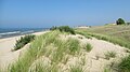
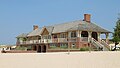
Algonac State Park
8732 River Road, Marine City
42°38′50″N 82°30′52″W / 42.647178°N 82.514528°W / 42.647178; -82.514528 (21 Algonac State Park )
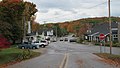
13
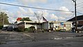
Algonac, Michigan (downtown, post office, Algonac–Clay Library, Algonac City Offices, road signage, Algonac Clay museum, Maritime museum)
1307 St Clair River Dr, Algonac
42°37′12″N 82°31′47″W / 42.619903°N 82.529668°W / 42.619903; -82.529668 (13 Algonac downtown ) 42°36′59″N 82°31′57″W / 42.616319°N 82.532576°W / 42.616319; -82.532576 (13 Algonac post office ) 42°37′35″N 82°31′25″W / 42.626380°N 82.523662°W / 42.626380; -82.523662 (13 Algonac library ) 42°37′00″N 82°31′56″W / 42.616669°N 82.532336°W / 42.616669; -82.532336 (13 Algonac city offices ) 42°37′59″N 82°30′58″W / 42.633153°N 82.516037°W / 42.633153; -82.516037 (13 Algonac road signage ) 42°37′11″N 82°31′48″W / 42.619589°N 82.529924°W / 42.619589; -82.529924 (13 Algonac Clay museum ) 42°37′07″N 82°31′51″W / 42.618639°N 82.530699°W / 42.618639; -82.530699 (13 Maritime museum )
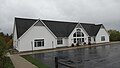
16
Walpole–Algonac Ferry
202 Fruit St, Algonac
42°37′08″N 82°31′49″W / 42.618980°N 82.530416°W / 42.618980; -82.530416 (16 Walpole-Algonac Ferry )
15
Russell Island (Michigan)
1130 St Clair River Dr, Algonac
42°37′05″N 82°31′52″W / 42.618054°N 82.531168°W / 42.618054; -82.531168 (15 Russell Island )
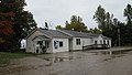
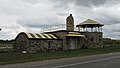
11
Clay Township, Michigan hall
4710 Pointe Tremble Rd, Algonac
42°37′18″N 82°34′21″W / 42.621765°N 82.572630°W / 42.621765; -82.572630 (11 Clay Township hall )
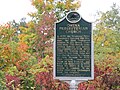
09
Colony Tower Complex historic marker
6503 Dyke Rd, Clay Township
42°37′56″N 82°36′55″W / 42.632327°N 82.615320°W / 42.632327; -82.615320 (09 Colony Tower Complex )
05
Ira Township, Michigan offices
7085 Meldrum Rd, Ira Township
42°41′24″N 82°40′08″W / 42.690085°N 82.669006°W / 42.690085; -82.669006 (05 Ira Township hall )
23
Cottrellville Township, Michigan hall
7008 Marsh Rd, Marine City
42°41′50″N 82°32′21″W / 42.697184°N 82.539251°W / 42.697184; -82.539251 (23 Cottrellville Township hall )
17
U.S. Bicycle Route 20 signage
Potential sign across from Ferry
42°37′08″N 82°31′49″W / 42.618987°N 82.530367°W / 42.618987; -82.530367 (17 Bicycle Route 20 )
10
Pearl Beach, St. Clair County, Michigan road signage
6211 Pointe Tremble Rd, Clay Township
42°37′41″N 82°36′15″W / 42.628003°N 82.604303°W / 42.628003; -82.604303 (10 Pearl Beach road signage )
07
Fair Haven, Michigan signage and post office
8680 Dixie Hwy, Fair Haven
42°40′43″N 82°39′06″W / 42.678727°N 82.651716°W / 42.678727; -82.651716 (07 Fair Haven post office )
01
Anchorville, Michigan road signage and post office
9828 Dixie Hwy, Anchorville
42°41′28″N 82°41′22″W / 42.691190°N 82.689491°W / 42.691190; -82.689491 (01 Anchorville post office )
22
Roberts Landing, Michigan signage
M-29 (across from state park)
42°39′12″N 82°30′52″W / 42.653292°N 82.514334°W / 42.653292; -82.514334 (22 Roberts Landing road signage )
08
Starville, Michigan road signage
7503 Starville Rd, Marine City
42°40′52″N 82°35′16″W / 42.681059°N 82.587786°W / 42.681059; -82.587786 (08 Starville )
12
M-154 (Michigan highway) (Harsens Island signage)
3647 Pointe Tremble Rd, Algonac
42°37′06″N 82°33′35″W / 42.618432°N 82.559604°W / 42.618432; -82.559604 (12 M-154 signage )
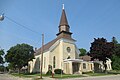
19
Saint Andrew's Episcopal Church
1507 St Clair River Dr, Algonac
42°37′17″N 82°31′43″W / 42.621353°N 82.528503°W / 42.621353; -82.528503 (19 St. Andrews Church )
20
LeRoy Smith House
9503 Frank St, Clay TownshipM
42°38′31″N 82°30′51″W / 42.641903°N 82.514278°W / 42.641903; -82.514278 (20 LeRoy Smith House )
14
Water Speed Capital
Across the street from City Hall
42°37′01″N 82°31′56″W / 42.616817°N 82.532152°W / 42.616817; -82.532152 (14 Water Speed Capital )
02
Immaculate Conception of Blessed Virgin Mary
9764 Dixie Hwy, Ira Township
42°41′30″N 82°41′19″W / 42.691663°N 82.688702°W / 42.691663; -82.688702 (02 Immaculate Conception of Blessed Virgin Mary )
03
Sacred Heart Cemetery
6890 Church Rd, Ira Township
42°41′42″N 82°41′23″W / 42.695138°N 82.689847°W / 42.695138; -82.689847 (03 Sacred Heart Cemetery )
04
St Mary's Cemetery
Across the street from Sacred Heart Cemetery
42°41′43″N 82°41′20″W / 42.695163°N 82.688876°W / 42.695163; -82.688876 (04 St Mary's Cemetery )
27
Marine City, Michigan (downtown, post office, city hall, road signage, library)
170 S Water St, Marine City
42°43′03″N 82°29′28″W / 42.717440°N 82.491219°W / 42.717440; -82.491219 (27 Marine City downtown ) 42°42′54″N 82°29′34″W / 42.714916°N 82.492899°W / 42.714916; -82.492899 (27 Marine City post office ) 42°43′03″N 82°30′02″W / 42.717599°N 82.500477°W / 42.717599; -82.500477 (27 Marine City offices ) 42°43′43″N 82°29′22″W / 42.728569°N 82.489417°W / 42.728569; -82.489417 (27 Marine City road signage ) 42°43′01″N 82°30′02″W / 42.716885°N 82.500488°W / 42.716885; -82.500488 (27 Marine City library )
34
East China Township, Michigan office
5111 River Rd, East China
42°45′31″N 82°28′56″W / 42.758654°N 82.482274°W / 42.758654; -82.482274 (34 East China Township hall )
35
China Township, Michigan office
4560 Indian Trail Rd, China Township
42°46′16″N 82°33′08″W / 42.771183°N 82.552330°W / 42.771183; -82.552330 (35 China Township hall )
37
Casco Township, Michigan hall
4512 Meldrum Rd, Casco
42°46′02″N 82°40′21″W / 42.767177°N 82.672554°W / 42.767177; -82.672554 (37 Casco Township hall )
39
Columbus Township, Michigan office
1732 Bauman Rd, Columbus
42°50′56″N 82°42′12″W / 42.848862°N 82.703303°W / 42.848862; -82.703303 (39 Columbus Township hall )
36
Peters, Michigan road signage
5322 Palms Rd, Casco
42°44′47″N 82°37′54″W / 42.746360°N 82.631619°W / 42.746360; -82.631619 (36 Peters road signage-community )
38N
Adair, Michigan
8033 St Clair Hwy, Casco
42°48′11″N 82°38′04″W / 42.802917°N 82.634424°W / 42.802917; -82.634424 (38 Adair road signage-community )
24
Catholic Pointe (Holy Cross Parish)
618 S Water St, Marine City
42°42′46″N 82°29′40″W / 42.712784°N 82.494331°W / 42.712784; -82.494331 (24 Catholic Pointe )
33
East China Fractional District No. 2 School
696 Meisner Rd, East China
42°45′13″N 82°29′27″W / 42.753688°N 82.490716°W / 42.753688; -82.490716 (33 East China School )
26
Newport Academy
405 S Main St, Marine City
42°42′58″N 82°29′40″W / 42.715989°N 82.494389°W / 42.715989; -82.494389 (26 Newport Academy )
31
Marine City City Hall historic marker
300 Broadway St, Marine City
42°43′12″N 82°29′31″W / 42.719891°N 82.491859°W / 42.719891; -82.491859 (31 Marine City City Hall )
29
Marine City Water Works
229 S Water St, Marine City
42°43′01″N 82°29′29″W / 42.717003°N 82.491523°W / 42.717003; -82.491523 (29 Marine City Water Works )
32
Ward-Holland House
433 N Main St, Marine City
42°43′27″N 82°29′21″W / 42.724152°N 82.489218°W / 42.724152; -82.489218 (31 Ward-Holland House )
25
David and Laura Lester House
406 S Main St, Marine City
42°42′58″N 82°29′40″W / 42.716234°N 82.494560°W / 42.716234; -82.494560 (25 David and Laura Lester House )
30
Greenwood Cemetery
444 Pleasant St, Marine City
42°43′26″N 82°29′40″W / 42.723994°N 82.494463°W / 42.723994; -82.494463 (30 Greenwood Cemetery )
28
Peche Island Rear Range Light
303 S Water St, Marine City
42°42′59″N 82°29′31″W / 42.716443°N 82.491884°W / 42.716443; -82.491884 (28 Peche Island Light ) 


.jpg)
.jpg)

.jpg)


.jpg)


.jpg)


.jpg)

.jpg)
_state_historic_marker.jpg)

.jpg)


.jpg)


.jpg)

.jpg)

.jpg)
.jpg)


 ✓
✓
 ✓
✓
 ✓
✓
.jpg) ✓
✓
 ✓
✓
 ✓
✓
_southern_terminus.jpg) ✓
✓
.jpg) ✓
✓
 ✓
✓
 ✓
✓
 ✓
✓
 ✓
✓
 ✓
✓
 ✓
✓
 ✓
✓
 ✓
✓
 ✓
✓
 ✓
✓
 ✓
✓
 ✓
✓
.jpg) ✓
✓
 ✓
✓
 ✓
✓
 ✓
✓
 ✓
✓
.jpg) ✓
✓

.jpg)
_northern_terminus.jpg)
.jpg)
.jpg)
.jpg)
.jpg)
.jpg)


_western_terminus.jpg)
.jpg)


_southern_terminus.jpg)
.jpg)
.jpg)


.jpg)

.jpg)


_state_historic_marker.jpg)
.jpg)
_2.jpg)
.jpg)
.jpg)
.jpg)

.jpg)
.jpg)

.jpg)

,_MI_road_signage.jpg)

.jpg)
_state_historic_marker.jpg)
.jpg)

.jpg)
.jpg)
.jpg)
_2.jpg)
.jpg)

.jpg)
.jpg)
_state_historic_marker.jpg)
.jpg)
.jpg)

.jpg)
.jpg)
.jpg)
.jpg)

.jpg)
.jpg)

.jpg)


.jpg)


.jpg)

.jpg)
.jpg)

.jpg)


.jpg)


.jpg)
,_MI_road_signage.jpg)


.jpg)
_historic_marker_1.jpg)
_historic_marker_2.jpg)
_2023.jpg)

.jpg)
_historic_marker.jpg)
.jpg)
_historic_marker.jpg)
.jpg)
_historic_marker.jpg)
.jpg)

.jpg)

.jpg)


,_Michigan_hall.jpg)
,_Michigan_hall.jpg)


.jpg)
_Marine_City,_MI.jpg)
_historic_marker.jpg)
.jpg)

.jpg)
_historic_marker.jpg)

.jpg)
.jpg)
.jpg)
_historic_marker.jpg)
.jpg)
.jpg)


 M-37 ✓
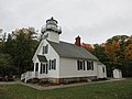


.jpg)

.jpg)
.jpg)

.jpg)

_northern_terminus.jpg)
.jpg)

.jpg)
.jpg)
.jpg)
.jpg)
.jpg)
.jpg)
_historic_marker.jpg)
.jpg)

.jpg)

.jpg)
.jpg)
.jpg)
.jpg)
_2.jpg)
.jpg)


 Ludington South Breakwater Light
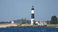


 Swedish Lutheran Church ✓
 Swedish Lutheran Church


_northern_terminus.jpg)
_southern_terminus.jpg)
.jpg)
.jpg)
.jpg)

.jpg)


.jpg)


.jpg)
_state_historic_marker.jpg)
_2023.jpg)


.jpg)
.jpg)