NeimWiki
Slow down the animation edit
Your gif is great but runs too fast. Could you slow it down? Refer to discussion here: Talk:Byzantine_Empire#The_gif_should_be_slowed_down,_right? Elias (talk) 05:33, 13 May 2022 (UTC)
1919 map edit
Hello! Recently, you've posted this map File:1919.5.1REGAT.png on the Hungarian–Romanian War article, and I wanted to ask: why is Henri Berthelot written over the Banat? Alin2808 (talk) 07:58, 12 August 2023 (UTC)
- Hey! He was in charge of the French forces occupying the region at the time. NeimWiki (talk) 19:35, 12 August 2023 (UTC)
Notice of Dispute resolution noticeboard discussion edit

This message is being sent to let you know of a discussion at the Wikipedia:Dispute resolution noticeboard regarding a content dispute discussion you may have participated in. Content disputes can hold up article development and make editing difficult. You are not required to participate, but you are both invited and encouraged to help this dispute come to a resolution.
Please join us to help form a consensus. Thank you!
OrionNimrod (talk) 21:20, 22 August 2023 (UTC)
Maps of Wallachia edit
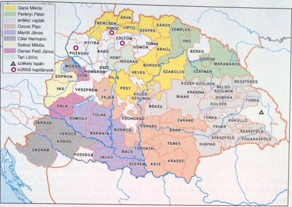
Hello! I've noticed a conflict arose around your maps which depict Wallachia and Moldavia in the Middle Ages. In order to avoid a predictable unnecessary, unproductive and nationalist dispute, I recommend that you distinguish between country borders and personal fiefdoms on your maps. Those lands were granted by the kings of Hungary to certain Wallachian (and/or Moldavian) rulers as personal assets. I.e. these territories did not belong to Wallachia nor Moldavia, consequently there were no Wallachian enclaves within the territory of Hungary. Let's see Fagaras (Fogaras), some Romanian rulers possessed it, but not continuously, as the kings also gave them to Hungarian landholders, mostly the voivodes of Transylvania (for instance, John Geréb was granted Fagaras from Matthias in the 1460s). So, I suggest, you should use a different color to present the personal fiefdoms of Ștefan cel Mare and Vlad, in addition to a legend with color code. Norden1990 (talk) 21:34, 22 August 2023 (UTC)
- Hello! I'm already distinguishing fiefs using labels and gray borders, as can be seen in https://upload.wikimedia.org/wikipedia/commons/9/9e/1404VOIVODATE.png. The colour of the fief itself is that of Wallachia and Moldavia because the relation was that of a personal union, as the Voivodes held the title of "Herzog of Fagaras and Amlas" and "Ban of Severin" and were therefore poltical property, not just personal.
- As with my other maps (such as User:NeimWiki#/media/File:1715PRINCIPATE.png), personal unions are shown to be the same colour as the senior partner, in this case Habsburg Austria. Were I to show junior partners of unions as a distinct colour, I'd have to do the same for the Grand Duchy of Lithuania and the Kingdom of Croatia, which while maintaining its own institutions, was still controlled by the Hungarian king. NeimWiki (talk) 22:01, 22 August 2023 (UTC)
- I notice a different approach here. Yes, Croatia, Lithuania or Bosnia, and even the Banate of Severin are political entities, but Fagaras, Amlas or Bologa are definitely not. These are lordships (i.e. estates with surrounding accessories, villages, mills, vineyards etc.) which were granted to some Wallachian monarchs. The "duke of Fagaras" is just mere a self-style title, according to these sources: [1], [2], [3]. The "ban of Severin" was a political position, not a royal or hereditary title, so in this case we cannot talk about a "personal union" either. Anyway, I own both Secular Archontology of Hungary (1301–1457) and Secular Archontology of Hungary (1458–1526) and I do not see at all that even a single Wallachian sovereign has held this office. I also provide you a correct definition of personal union: it is the combination of two or more states that have the same monarch while their boundaries, laws, and interests remain distinct. I do not think that Amlas or Fagaras would have been a "sovereign state". This assumption is ridiculous. Even the Banate of Severin does not meet this criteria, it was a frontier province of the Kingdom of Hungary. A distinction must be made between countries and private estates. At some point, Serbian Despot Đurađ Branković was one of the largest landowners in Hungary, he even possessed the important city Debrecen. I hope, you do not consider that there was a personal union between the "country" Debrecen and the Serbian Despotate during that time. For a non-Eastern European reader, your map is completely misleading. --Norden1990 (talk) 22:29, 22 August 2023 (UTC)
- None of these sources [1], [2], [3] mention the "Duchy of Fagaras" as a mere self-style title, which is a confusing claim to begin with. In fact, they all claim Fagaras was a Vlach region (Terra Blacorum, presumably autonomous as many historians claim) which was used as a bargaining chip by Hungarian kings to compel Wallachian Voivodes.
- What exactly do you mean when you say Fagaras and Amlas (which were always grouped together) were not a political entity? The title of "Duke of Fagaras and Amlas" did exist, which you do not deny (but instead minimise as a "self styling title" which doesn't really mean anything), Wallachian voivodes did control these regions, and even in times when they did not Vlach Law was still used.
- "I do not see at all that even a single Wallachian sovereign has held this office." Are you saying Wallachian Voivodes did not hold the "Ban of Severin" title? Your wording is off, but eitherway the sources you've cited above ([1], [2], [3]) claim otherwise. I'm confused because I haven't seen anybody ever doubt Wallachian rulers held this title, as it is well documented that multiple Voivodes included it in their feudal titles, such as Mircea cel Batran „Eu, întru Hristos Dumnezeu binecredincios și binecinstitor și de Hristos iubitor și autocrat, Io Mircea mare voievod și domn din mila lui Dumnezeu și cu darul lui Dumnezeu, stăpânind și domnind peste toată Țara Ungrovlahiei și a părților de peste munți, încă și către părțile tătărești și Amlașului și Făgărașului herțeg și domnitor al Banatului Severinului și pe amândouă părțile pe toată Podunavia, încă până la marea cea mare și stăpânitor al cetății Dârstorului”.
- Your idea of a personal union is also very rigid. Our modern concept of a "sovereign state" (a country as you seem to simply) should also not be used when reffering to feudal entities. While polities like the Banate of Severin or the Duchy of Fagaras and Amlas were obviously in the lower ranks of the feudal hierarchy, they were nonetheless legal titles with assigned territories and customs.
- I'm not going to comment on Đurađ Branković, as I personally am not familiar with his relation to Hungary, but if he held a title along the lines of "Duke of Debrecen" while he was still Despot in Serbia then yes i would consider there to be a personal union between the two areas, under Hungarian suzerainty. NeimWiki (talk) 23:18, 22 August 2023 (UTC)
- Your map clearly detach Fogaras, Severin, Almas, Bologa (A big patch in the center of Hungary as a Wallachian state in 1404 during King Sigismund! - ridiculous) from the Kingdom of Hungary:https://upload.wikimedia.org/wikipedia/commons/9/9e/1404VOIVODATE.png
- You emphasize the state borders with a thin black line, and you just use gray line and the Wallachian yellow patch color and Wallachian yellow text color to show those regions are intergral part of Wallachia, which is incorrect.
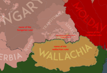
- I offered a solution: use hard thick line to the state borders, use gray line for all inside divisions, and use some kind of legend to explain the different colors, it would be good to show the name of rulers and the vassalage status, but Fogaras cannot be the same color as Wallachia. Btw if you use light green for Ottoman vassal areas, why yo do not use the similar color as Hungary to show Moldavia and Wallachia as vassal state (it was many times). Why do you show many different light colors inside Hungary? Why do you use the same color for Serbia and for the Szekelys? The Szekelys or Kunsag were not vassals, but integral part of Hungary.
- Anyway we need to follow academic history maps not our fantasy this is not a personal blog where you can paint half Europa as part of Wallachia.WP:NOR OrionNimrod (talk) 10:25, 23 August 2023 (UTC)
- When making claims, you should back them up using sources. Simply saying "Fagaras, Severin, Amlas, Bologa were not Wallachian possessions" is a baseless claim, as you have not yet provided me any evidence these were not controlled by the Voivode. These grants by Sigismund to Mircea are well documented (even mentioned and sourced in several wikipedia articles) , your baseless denial of their existence reeks of nationalist fever. Hungarian kings exchanged these territories in exchange for the Voivode's subordination.
- The Szekelys and Cumans, as well as the Saxons held autonomous seats inside the Kingdom of Hungary, and I'm showing them as such. Same goes for the Vlach autonomies in my other maps. Serbia is shown in the same colour because at this point in time it was a Hungarian vassal, I see no need to make up even more colours, as their dependence on the Hungarian king was similar, and lower titles are shown separate from higher titles using black, gray and light gray delimitations.
- In times Wallachia and Moldavia were Hungarian vassals I do show them as such using a thick baige outline, as can be seen in User:NeimWiki#/media/File:1404VOIVODATE.png. Mircea lead a very independent foreign and internal policy within Wallachia, which is why he is not shown in the same colour as all the other Hungarian vassals, and I have no qualms about showing either Wallachia or Moldavia in that manner like you seem to be implying, as can be seen in User:NeimWiki#/media/File:1345VOIVODATE.png and User:NeimWiki#/media/File:1419VOIVODATE.png (in this specific period, the Voivode was both a vassal of the Hungarian king through his fiefs and paid tribute to the Ottomans).
- As I've told you before, if you manage to find a reliable source that mentions Vlad III was a vassal of Matthias Corvinus in 1457 and 1461, then I will update my map.
- Please keep this discussion civilised, source your arguments, and refrain from claiming I'm somehow going against "academic history maps" and making "half Europa as part of Wallachia". We're talking about castles and villages. NeimWiki (talk) 11:47, 23 August 2023 (UTC)
- NeimWiki, a small comment here.
- "A personal union is the combination of two or more states that have the same monarch while their boundaries, laws, and interests remain distinct."
- The city of Debrecen that was used as an example was a 100% integrated part of the Kingdom of Hungary. I consider the fact undeniable that there was a huge difference between fiefdoms and countries. Gyalu22 (talk) 12:22, 23 August 2023 (UTC)
- NeimWiki, I do not say that certain period Fagaras, Severin, Amlas, Bologa were not fiefs of the Wallachian ruler (however need check that info exactly when), but it is the baseless claim that you want clearly detach those regions from Hungary because the Hungarian king donated land from Hungary them to their vassals as fedual estate posession, the Hungarian king was their overlord and those regions were integral part of the Hungarian crown. After those fiefs the Wallachian nobles needed pay for the Hungarian king feudal taxes, and Hungarian king took back anytime, as in the example Matthias did.
- If the English king donate a house in London to a Romanian person for control, that house in London will not part of Romania because of that :)
- I understand that you want to show Wallachian fiefs, but I provided a solution for that, and it would also good to show the year on the map not just on the file name. Btw why you do not show the estates of all nobles in the Kingdom of Hungary, why only the Wallachian fiefs? There were many hundred and thousands estates, overlords-sublords etc
- Serbia was Hungarian vassal but Szekely, Saxon, Iazyges areas inside Hungary was not a vassal areas but integral part of Hungary, they should be different color than Serbia.
- Title of Sigismund in the Hungarian first decree of 1405: "Sigismund, by the Grace of God, King of Hungary, Dalmatia, Croatia, Rama, Serbia, Galicia, Lodomeria, Cumania and Bulgaria, Margrave of Brandenburg, Chief Chamberlain of the Holy Roman Empire, Heir of Bohemia and Luxemburg."''[1] = Transylvania, Szekelyland, Iazyges... were not a separate regions.
- Hungarian academic maps about the reign of Sigismund, I do not see that those regions would detach from Hungary, on all maps the Hungarian state borders are same: [4]
- https://rubicon.hu/kepek/article/5157/0405-d6d03cff-7cfb-4ad9-b4f9-1ff7d117025d-in_content.jpg
- https://player.slideplayer.hu/76/12698845/slides/slide_2.jpg
- 1392-95
- https://docplayer.hu/docs-images/92/108380273/images/32-1.jpg
- 1404
- https://docplayer.hu/docs-images/92/108380273/images/46-0.jpg
- lords:
- https://docplayer.hu/docs-images/92/108380273/images/62-1.jpg
- lords:
- https://m.blog.hu/di/digitori/image/12.jpg
- lords 1433
- https://mek.oszk.hu/00900/00940/html/img/nagy/4272.jpg
- Sigismund reign, from Hungarian history schoolbook
- https://nat2012.nkp.hu/tankonyv/tortenelem_9/lecke_05_045.html
- Maps from the MTA (Hungarian Academic Science) - Elte University, Research Centre for the Humanities, Institute of history. I doubt that you know better the maps of Hungary than the Hungarian historians however you want supervise the history of Hungary
- https://tti.abtk.hu/terkepek?start=10
- I notice a different approach here. Yes, Croatia, Lithuania or Bosnia, and even the Banate of Severin are political entities, but Fagaras, Amlas or Bologa are definitely not. These are lordships (i.e. estates with surrounding accessories, villages, mills, vineyards etc.) which were granted to some Wallachian monarchs. The "duke of Fagaras" is just mere a self-style title, according to these sources: [1], [2], [3]. The "ban of Severin" was a political position, not a royal or hereditary title, so in this case we cannot talk about a "personal union" either. Anyway, I own both Secular Archontology of Hungary (1301–1457) and Secular Archontology of Hungary (1458–1526) and I do not see at all that even a single Wallachian sovereign has held this office. I also provide you a correct definition of personal union: it is the combination of two or more states that have the same monarch while their boundaries, laws, and interests remain distinct. I do not think that Amlas or Fagaras would have been a "sovereign state". This assumption is ridiculous. Even the Banate of Severin does not meet this criteria, it was a frontier province of the Kingdom of Hungary. A distinction must be made between countries and private estates. At some point, Serbian Despot Đurađ Branković was one of the largest landowners in Hungary, he even possessed the important city Debrecen. I hope, you do not consider that there was a personal union between the "country" Debrecen and the Serbian Despotate during that time. For a non-Eastern European reader, your map is completely misleading. --Norden1990 (talk) 22:29, 22 August 2023 (UTC)

OrionNimrod (talk) 14:12, 23 August 2023 (UTC)
- We're going in circles so this will be my last reply to you, unless you provide something substantial:
- "I do not say that certain period Fagaras, Severin, Amlas, Bologa were not fiefs of the Wallachian ruler"
- Here is you saying that exact thing "Your map clearly detach Fogaras, Severin, Almas, Bologa (A big patch in the center of Hungary as a Wallachian state in 1404 during King Sigismund! - ridiculous) from the Kingdom of Hungary", of course they're shown as Wallachian, they were controlled by the Wallachian Voivode. I guess you have to live with the fact the Wallachian Voivode owned a couple villages in Transylvania.
- "but it is the baseless claim that you want clearly detach those regions from Hungary because the Hungarian king donated land from Hungary them to their vassals as fedual estate posession, the Hungarian king was their overlord and those regions were integral part of the Hungarian crown. After those fiefs the Wallachian nobles needed pay for the Hungarian king feudal taxes, and Hungarian king took back anytime, as in the example Matthias did."
- Yes, the Hungarian king donated land from Hungary to their vassal, the Wallachian Voivode, and thereafter it became the Voivode's political property, hence why its shown as Wallachian. When the Voivode was a nominal vassal of Hungary, he is outlined as such. When the Voivode was a loyal vassal of Hungary, he is outlined as such (minus the Ottoman colour, I have not yet made a map when Wallachia was only a Hungarian vassal). In the map that you keep removing, Vlad III was not a Hungarian vassal, and yet is still documented to have controlled the Duchy of Fagaras and Amlas. As I've told you twice now, if you manage to provide a reliable source that says otherwise, I will update my map.
- "If the English king donate a house in London to a Romanian person for control, that house in London will not part of Romania because of that :)"
- This is not a good analogy, we don't live in feudal Europe anymore and the Hungarian king gave the Wallachian Voivode (as in the leader of the Principality, not a commoner) landed titles, i.e. Duchy of Fagaras and Amlas and the Banate of Severin.
- "I understand that you want to show Wallachian fiefs, but I provided a solution for that, and it would also good to show the year on the map not just on the file name. Btw why you do not show the estates of all nobles in the Kingdom of Hungary, why only the Wallachian fiefs? There were many hundred and thousands estates, overlords-sublords etc"
- You provided a solution to a non-existent problem based on your own preferences, not historical reality. Had leaders of other countries been donated landed titles inside the Kingdom of Hungary then yes I would show them as well, but as of now I'm not aware of any such people. Maybe you could source some so I could update my maps?
- "Title of Sigismund in the Hungarian first decree of 1405: "Sigismund, by the Grace of God, King of Hungary, Dalmatia, Croatia, Rama, Serbia, Galicia, Lodomeria, Cumania and Bulgaria, Margrave of Brandenburg, Chief Chamberlain of the Holy Roman Empire, Heir of Bohemia and Luxemburg."'' = Transylvania, Szekelyland, Iazyges... were not a separate regions."
- The Szekelys, Cumans and Saxons (and at a certain point Vlachs) were given privileges within their polities, having a relative level of self-rule and self-organisation. That is why they're shown as autonomous, which you seem to ignore. Based on this logic, were I to make a map of the Holy Roman Empire, I'd have to show it as a unified and continuous polity.
- "Hungarian academic maps about the reign of Sigismund, I do not see that those regions would detach from Hungary:"
- None of these maps prove anything, they are very simplistic interpretations of feudal politics meant to be used in history manuals to be easily digestible. You also cannot contain 50 years of history in a single map, borders were constantly changing and Sigismund himself held other landed titles outside of Hungary. And as I've told you before, maps are not sources and if you want me to take anything you say seriously please provide written documents, chronicles or passages from history books. NeimWiki (talk) 14:52, 23 August 2023 (UTC)
- NeimWiki, I see you have still understanding problem, if Wallachian voivodes had estates in Hungary it does not mean those estates were part of another country as you pretend.
- Your black outline cleary show the separate countries and your yellow color pretend that those regions are a separate. You can you text to show this instead of deatch from Hungary.
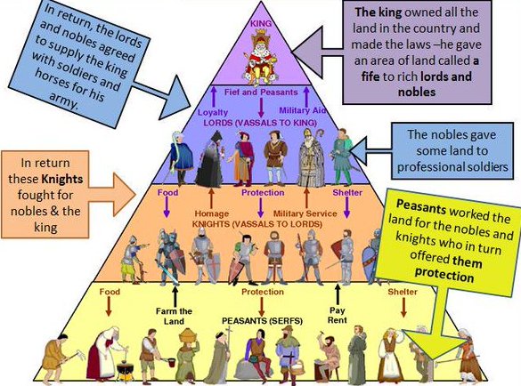
- I see you do not understand the feudal system: the king owned all the land in the country, he gave a land called fief for nobles: https://www.internationalschoolhistory.net/IB/myp_history/4/unit1/images/feudal_system.jpg Then those noble overlords gave more lands from their fief land to another nobles who are they sublords
- Following your logic, we could detach from Hungary all lands which was not royal estates?
- Those Hungarian maps clearly prove the southern border of Transylvania was the same borderline, it was not a big gap a big area which was part of Wallachia.
- There are many provided maps which shows only some years or magnates areas as all part of Hungary and not as part a separate state as you want to pretend.
- In that 50 year the Hungarian key state borders were same, or do you deny? What do you think which borders changes? Only vassal regions changed not the key Hungarian crown land.
- Those maps created by academic Hungarian historians, I bet they know much better the Hungarian history than you. Anyway it is a Wikipedia rule that we need follow academic maps not our fantasy and personal beliefs. OrionNimrod (talk) 15:08, 23 August 2023 (UTC)
I would like to respond your arguments above. There was no such "Duchy of Fogaras", it is an OR on your part. It is similar to the Duke of Cambridge, it's a hereditary title but there is no "Duchy of Cambridge". "Duke of Fagaras" is nothing more than a noble title in Hungary (whether self-style or not). Before the 16th century, there were no hereditary noble titles in Hungary. It is irrelevant that the territory belonged to the privileges of local Vlach communities. It was under Hungarian suzerainty and jurisdiction, Wallachia as a sovereign state has nothing to do with it. So, yes, Fagaras and Amlas were not political entities. There were royal properties, which were granted to some Wallachian (and later Moldavian) rulers occasionally.
Yes, I check the two archontological works above (used by international historiography too), and the position of Ban of Severin were held by Hungarian lords in the 14–16th centuries. The title usage of the Wallachian monarcha is not authoritative. The kings of Hungary also bore the title King of Jerusalem since the 13th century, but they never governed the Holy Land. Anyway, the Ban of Severin is merely a political position, similarly to e.g. the Palatine of Hungary or the Master of the treasury. Its office-holder was a member of the Hungarian royal council. I can repeat myself, it was not a hereditary, royal or noble title, but it was a political dignity. Consequently, we cannot speak about a "personal union" between the Banate of Severin (or the non-existing "Duchy of Fagaras") and the Principality of Wallachia. This is a completely nonsensical attitude, it seems that you need to supplement your knowledge of medieval law. I do not understand your resistance against the facts. For instance, the image File:Tara Rumaneasca map.png is an absolutely acceptable image: it uses different colors, contains a legend which states the orange parts are fiefdoms held by Mircea personally (and not Wallachia). --Norden1990 (talk) 21:07, 23 August 2023 (UTC)
- According to NeimWiki, if a Romanian man buys a huge estate in USA, or if the president in India grants him a forest for 100 years, then those lands become part of Romania. :)
- NeimWiki quoted: "stăpânind și domnind peste toată Țara Ungrovlahiei și a părților de peste munți " "ruling and reigning over all the Land of Ungrovlahia and the parts beyond the mountains"
- So if the land was Hungarian-Wallachia, why do not NemWiki paint Wallachia as the same color as Hungary? Or why do not NemWiki write Ungrovlahia there instead of Wallachia? OrionNimrod (talk) 10:33, 29 August 2023 (UTC)
POV-pushing edit
Stop this kind of POV-pushing, or I will report your activity to the administrators. Your maps contain obvious POV, factual errors and unsourced claims. You were unable to answer the previous objections by several editors. Use talkpage and discuss the problem before making such disruptive edits. Norden1990 (talk) 19:34, 26 August 2023 (UTC)
Introduction to contentious topics edit

You have recently edited a page related to Eastern Europe or the Balkans, a topic designated as contentious. This standard message is designed as an introduction to contentious topics and does not imply that there are any issues with your editing.
A special set of rules applies to certain topic areas, which are referred to as contentious topics. These are specially designated topics that tend to attract more persistent disruptive editing than the rest of the project and have been designated as contentious topics by the Arbitration Committee. When editing a contentious topic, Wikipedia’s norms and policies are more strictly enforced, and Wikipedia administrators have special powers in order to reduce disruption to the project.
Within contentious topics, editors should edit carefully and constructively, refrain from disrupting the encyclopedia, and:
- adhere to the purposes of Wikipedia;
- comply with all applicable policies and guidelines;
- follow editorial and behavioural best practice;
- comply with any page restrictions in force within the area of conflict; and
- refrain from gaming the system.
Editors are advised to err on the side of caution if unsure whether making a particular edit is consistent with these expectations. If you have any questions about contentious topics procedures you may ask them at the arbitration clerks' noticeboard or you may learn more about this contentious topic here. You may also choose to note which contentious topics you know about by using the {{Ctopics/aware}} template.
Robert McClenon (talk) 03:58, 27 August 2023 (UTC)
- Hi Robert McClenon, putting fake own photoshopped maps and edit war still in progress in 5 articles. OrionNimrod (talk) 12:29, 4 September 2023 (UTC)
ArbCom 2023 Elections voter message edit
Hello! Voting in the 2023 Arbitration Committee elections is now open until 23:59 (UTC) on Monday, 11 December 2023. All eligible users are allowed to vote. Users with alternate accounts may only vote once.
The Arbitration Committee is the panel of editors responsible for conducting the Wikipedia arbitration process. It has the authority to impose binding solutions to disputes between editors, primarily for serious conduct disputes the community has been unable to resolve. This includes the authority to impose site bans, topic bans, editing restrictions, and other measures needed to maintain our editing environment. The arbitration policy describes the Committee's roles and responsibilities in greater detail.
If you wish to participate in the 2023 election, please review the candidates and submit your choices on the voting page. If you no longer wish to receive these messages, you may add {{NoACEMM}} to your user talk page. MediaWiki message delivery (talk) 00:59, 28 November 2023 (UTC)
- ^ Dr. Pomogyi, László. "Ezer év törvényei – 1405. évi (I. decrétum) törvénycikkek (Corpus Juris Hungarici Magyar Törvénytár)" [Laws of a Thousand Years – Law articles of 1405 (Decree I) (Corpus Juris Hungarici, Hungarian Law Library)]. net.jogtar.hu (Online Hungarian Legal Register). Wolters Kluwer. Retrieved 2023-05-28.
Zsigmond, Isten kegyelméből Magyarország, Dalmácia, Horvátország, Ráma, Szerbia, Galícia, Lodoméria, Kunország és Bulgária királya, brandenburgi őrgróf, a Szent Római Birodalomnak főkamarása Csehország és Luxemburg örököse.