User talk:Acps110/Archives/2011/December
| This page is an archive of past discussions. Do not edit the contents of this page. If you wish to start a new discussion or revive an old one, please do so on the current talk page. |
User:173.8.9.25
It seems that the rest of his edits are vandalism too. I don't know to warn users nor to undo multiple edits, and I am not sure which of his edits are vandalism. I tried to report him, but was declined. Vcohen (talk) 21:02, 19 December 2011 (UTC)
- There are many templates for warning users. Just copy and paste the appropriate one onto a User's talk page, and then you'll have better luck when you report them at AIV. Generally, Admins like to see an escalating Level 1, 2, 3 and 4 on the user's talk page before they block them, but there are exceptions. Acps110 (talk • contribs) 23:56, 19 December 2011 (UTC)
The 4 and the IRT Jerome Avenue Line
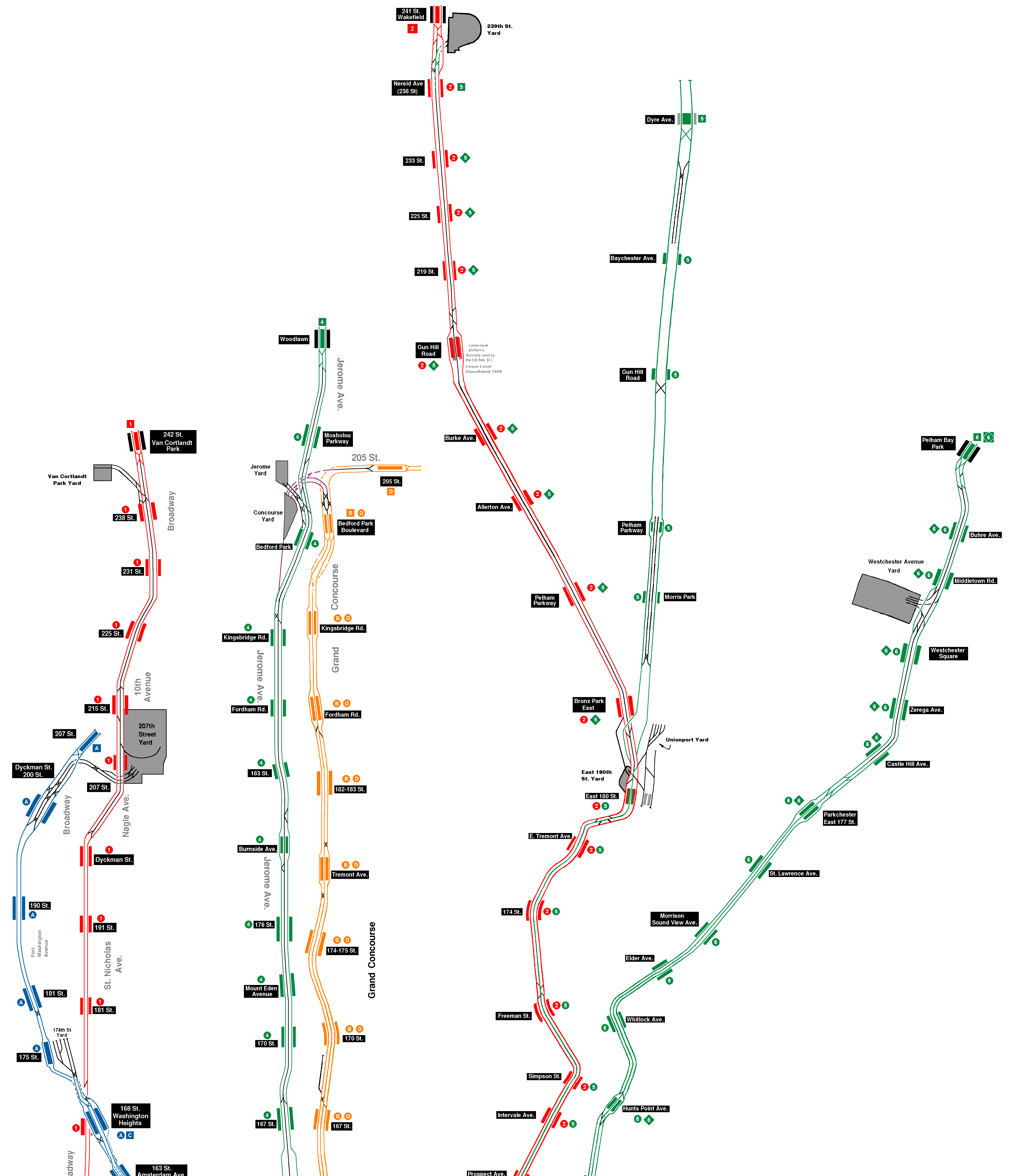
What is special in the track configuration near 161st and 167th Streets of IRT Jerome Avenue Line? The number of tracks is still 3, and only 2 of them are in use. Where am I wrong? Vcohen (talk) 21:55, 3 November 2011 (UTC)
- The express track begins south of 138th Street via a diverge from both tracks. There are diamond crossovers north of 149th Street from both local tracks to the center express track. North of 167th Street there are two single crossovers, to the middle track northbound and from the middle track southbound. See the track maps, Uptown and North from this page. Given the fact that the schedule shows the express track in use by revenue trains from 125th Street to 149th Street and from 167th Street to Burnside Ave, it is not appropriate to say that the two stations in between don't have revenue service on their middle tracks. It's original research to say either way. Acps110 (talk • contribs) 22:06, 3 November 2011 (UTC)
- There's something that I don't catch. I have both those maps and those schedules saved on my local disk and permanently check myself using them, and still don't understand what kind of information we can get from them now. There are many crossovers in the system, and none of them lead to such a conclusion. The schedule, as far as I see, doesn't show tracks. Tell me please, is there a train that skips these two stations? Vcohen (talk) 22:32, 3 November 2011 (UTC)
- P.S. The schedule explicitly shows in white the stations that are sometimes skipped/bypassed, and in black the stations that are always served. There is 1 white station, 3 black ones and 3 white ones. The 2 discussed stations belong to the series of 3 black ones.
Moreover, I suspect that even after the 3 black stations the train stays on the local track and skips the white stations like a skip-stop train. There is no crossover that would allow switching back to the local track before Burnside. Also, the schedule says 'non-stop' and not 'express'. Vcohen (talk) 10:43, 4 November 2011 (UTC)- P.P.S. No, I'm sorry. It's a full express (after 167th Street), and it stops in the middle of the Burnside Avenue station. But the tracks configuration allows this. Vcohen (talk) 17:32, 4 November 2011 (UTC)
- Those trains that run express, terminate at Burnside Avenue and then go to the yard.
- Your comment about reading the schedule and trying to figure out which tracks are used goes back to my problem at the beginning. We are both using original research and synthesis to say which tracks are used. That is why I was uncomfortable even including it at all. That is why I removed it from those two stations (161 and 167) by saying, "based on the track configuration in the area" and service patterns, "this is not appropriate here." In other words, it is unsourced information. Acps110 (talk • contribs) 17:43, 5 November 2011 (UTC)
- But at least according to the source, "Train always operates and always stops here." We are writing sourced articles, aren't we? Vcohen (talk) 18:40, 5 November 2011 (UTC)
- P.S.
- Thank you for checking my work, today too. I hope that was the last time.
- I keep waiting for the final decision on 161st and 167th Streets of IRT Jerome Avenue Line. I need it to continue with my layout diagrams.
- Can you tell me what's wrong with Roosevelt Avenue / 74th Street that appears in the text as Jackson Heights – Roosevelt Avenue / 74th Street – Broadway? Vcohen (talk) 15:58, 7 November 2011 (UTC)
- As to the tracks at 161st and 167th; yes the 4 train always stops there, but there may be a delay to service as an in-service 4 train bypasses them on the middle track. That's why I removed "2 in revenue service". I would prefer the infoboxes for both stations remain as "3 tracks" with no extra information. We can't discover from the schedule what tracks are used, see WP:SYNTH.
- The Jackson Heights complex was decided by consensus to shorten name of the article. The text however, includes the full name of the complex in the lead. Acps110 (talk • contribs) 18:09, 16 November 2011 (UTC)
By Division and then by Line, North to South:
| IRT: | BMT: | IND: |
|---|---|---|
|
|
|
Those stations containing tracks which can't serve passenger trains are marked as "passenger" service. Regular service includes tracks not regularly served by passenger trains but can be at a moment's notice. Acps110 (talk • contribs) 20:44, 16 November 2011 (UTC)
- slightly modified CPW 8th Ave line stations. Acps110 (talk • contribs) 01:18, 20 November 2011 (UTC)
- Seven times wow and thank you. I'm taking a time out to compare your list with mine. I believe there will be a lot of questions. Vcohen (talk) 21:24, 16 November 2011 (UTC)
- Well, here are my questions.
- I couldn't find Borough Hall station on the IRT Lexington Avenue Line. I suppose you mean the Borough Hall station on the IRT Eastern Parkway Line.
- I couldn't find in your list two stations of the IND Sixth Avenue Line: 57th Street and Grand Street. I suppose that both simply have 2 tracks.
- "Dyre: Baychester to Pelham Pkwy: 4 (2 in regular service; 1 abandoned)" - do you mean 3 tracks?
- "Nassau: Bowery to Canal: 4 (2 in regular service, 1 abandoned)" - the same question.
- "Franklin: Franklin to Park Pl: 2 (1 abandoned)" - the articles say that the second track doesn't exist any more, who is right? Vcohen (talk) 18:01, 20 November 2011 (UTC)
- Yes you are correct, Borough Hall on the Eastern Parkway line; two tracks used by the 4 and 5 trains.
- Both 57th Street and Grand Street have two tracks each. (I consider the 57th Street station to be part of the IND 63rd Street line, but most others don't.) (Forgot to include Grand Street)
- The Dyre line was originally four tracks. Just like the Sea Beach line, one track has fallen into disuse.
and has been disconnected. On the Dyre line that track is the Dyre Ave-bound express from just south of the platform at Pelham Parkway to south of Dyre Ave. The track is still in place for some of that distance but is not accessible by any trains.The track is usable at Morris Park, but trains entering it would have to reverse to get back out of it. On the Sea Beach line, that is the Coney Island-bound express which is disconnected from where the line begins east of Fourth Ave until just west of Kings Highway. From Kings Highway to south of 86th Street all four tracks are usable. (Both of the express tracks that remain usable on these lines are available to trains in either direction.) (I watched a crazy YouTube video of a Dyre line express several years ago, that I can't find. It made a stop at East 180th St, diverged to the Dyre line, crossed over from the northbound local to the southbound express south of Morris Park, stopped at Pelham Parkway, then ran express to Dyre Ave.) - The Nassau Street line was reconfigured in 2004 from four tracks to two tracks. The former Brooklyn-bound local track still exists from north of Chambers Street through to Essex Street. (If an in-service J or Z train were rerouted via that track it would run express from Chambers St to Essex Street.) The express track in that same direction was removed. The remaining two western tracks are the current tracks in service at Canal and Bowery; Thus 4 tracks, 1 abandoned. The M train uses the Brooklyn-bound local track from the Chrystie Street Connection through Essex Street station before merging with the J to cross the Williamsburg Bridge.
- The Franklin line was two tracks, but the platforms at both Park Place and Franklin Avenue were reconstructed over the western trackway in 1998, and are now single track only. Acps110 (talk • contribs) 19:36, 20 November 2011 (UTC)
- (removed Borough Hall from list) Acps110 (talk • contribs) 05:33, 21 November 2011 (UTC)
Station Infobox Text IRT Dyre Avenue Line Baychester Avenue 3 three tracks with space for a fourth Gun Hill Road 3 three tracks and space for a fourth Pelham Parkway 3 (2 in revenue service) plus 1 unused trackway the two local tracks remain in revenue service, and the southbound express track remains in use as a test track BMT Nassau Street Line Bowery 4 (2 in regular service, one abandoned track removed) three tracks <...> On the abandoned side, only the outer track remains Canal Street 3 (2 in revenue service) three tracks <...> the northbound express stub track was removed BMT Sea Beach Line Eighth Avenue to Bay Parkway 4 (2 in revenue service) four tracks <only Fort Hamilton Parkway has no description> IND Rockaway Line Howard Beach – JFK Airport 4 (2 in revenue service) four tracks
- Some of these articles give the impression that there are 3 tracks there. The one that has been removed is not counted.
- In contrast, some of them give the impression that there are 4 tracks there. None of them is removed, the 4 are distributed as 2 in use and 2 not in use.
- When I see "4=2+1" I want to ask "where is the 4th"...
- What do you suggest to change? Vcohen (talk) 15:11, 22 November 2011 (UTC)
- After more research, it appears the fourth track on the Dyre line has been removed from south of Pelham Parkway to south of Dyre Ave. So those stations should be "3 with space for 4<br>(2 in regular service)". Morris Park should still be "4 (2 in regular service)". All tracks are usable.
- On the Nassau Street line, three tracks are installed with the fourth removed. All three tracks are usable. As I mentioned above, the eastern platforms at Canal and Bowery are unusable.
- On the Sea Beach line, all stations have four tracks. From Eighth Avenue to west of Kings Highway only three are usable. From Kings Highway south, all four are usable.
- Howard Beach has four tracks installed but only three are usable. Here is a video of a Far Rockaway-bound A train using the Manhattan-bound express track at Howard Beach. Aqueduct and Aqueduct Racetrack also have four installed but only two are usable.
- OK. 4 infoboxes have been fixed.
- Now, the question is how to formulate. We have 3 kinds of tracks: a) in use, b) usable that aren't in use, c) unusable. (I don't want to add a new level of detail to speak about bi-directional tracks, because there are tracks built as north- or southbound and used as bi-directional.)
- When we say "3 (2 in regular service)", we mean "2 in use and 1 usable". When we say "3 (2 in passenger service)", we mean "2 in use and 1 unusable". Thus, we apply different attributes to the 2 used tracks, while the actual difference is in the unused one. Therefore I would prefer to say something like "3 (1 not in regular service)" and "3 (1 not in passenger service)".
- In this case the wording "4 (2 in regular service; 1 abandoned)" becomes "4 (1 not in regular service; 1 abandoned)". The 2 remaining tracks not listed in the brackets are just in use, it's the default, we don't need to say it explicitly.
- What do you think? Vcohen (talk) 14:08, 23 November 2011 (UTC)
- I think we should split the two different terms. I would say 3 (2 in regular service) for 2 in service, 1 usable and 3 (1 not in passenger service) for 2 in service, 1 unusable. For the abandoned tracks, how about 4 (1 occasional use; 1 abandoned)? I would prefer we favor tracks usable but when tracks are unusable or abandoned then say that instead. Tracks usable would be the norm. Acps110 (talk • contribs) 02:26, 24 November 2011 (UTC)
- Occasional use is again something new. It may mean a certain part of usable tracks that are actually sometimes used. I don't have this information.
- There are too many combinations even of the above mentioned three (or four) kinds. Let's organize these cases first. Look:
in use usable unusable or
abandonedremoved or
not installedwording 2 1 3 (2 in regular service) 2 1 3 (1 not in passenger service) 2 1 1 ? 2 1 ? 2 1 1 ?
- Another problem is abandoned levels. The Nevins Street (IRT Eastern Parkway Line) article gives us examples of both problems. "A fifth track once existed between the two express tracks. <...> ...an unused lower level platform. Next to this platform is a single unused trackway." So, the station has 4 used tracks and 2 non-existing ones, one of them on the same level and one on the lower level that is abandoned. The infobox says, "4 (upper level)<br>1 (lower level – abandoned)."
- Does your approach cover all these examples? Vcohen (talk) 16:38, 24 November 2011 (UTC)
- Edited Vcohen (talk) 16:59, 25 November 2011 (UTC)
Do we need to define rules for these "special cases"? How can we keep this simple in the infoboxes? If the track layout is too complicated to cull into two to four terms then perhaps it doesn't belong in the infobox. All of these complicated track layouts are or should be defined in the articles. The infobox is more for "at-a-glance" types of information. For Nevins Street, I now am favoring a much simpler "4 tracks" with nothing extra in the infobox. We are defining what serves the station, not what doesn't. What can be seen from the platforms vs. what passes through the area unseen.
This is why I have removed extra tracks from multi-level lines such as the Lexington Avenue line on the Upper East Side. Sure the express tracks pass under 116th Street station, but they don't serve that station.
A converse argument could be made for an elevated station such as 111th Street on the Flushing line. For that station, I would say 5 (3 in regular service). All five tracks can be seen from the platforms and it may be more useful to put that in the infobox. The details of the yard tracks and the flyover could still be left out of the infobox and instead put in the text of the article.
I'm changing my mind for the Dyre line, that should say 3 (2 in regular service). The articles can say "originally four tracks, now 3, etc, etc." Same thing for the Nassau Street line, 3 (2 in regular service). Any tracks not installed shouldn't be in the infobox. Only what exists and can be seen from the station's platforms. I've changed the above table to reflect this. Acps110 (talk • contribs) 21:20, 25 November 2011 (UTC)
- So, this is what we have as of now:
in use usable unusable or
abandonedwording 2 1 3 (2 in regular service) 2 1 3 (1 not in passenger service) 2 1 1 4 (2 in regular service, 1 not in passenger service)
- Is it correct?
- Later I will coordinate with you the whole list. Now I want to ask once more about the IRT Jerome Avenue Line (to justify the caption that we are discussing under). According to the described classification, the additional track passing through the 149-161-167 Streets seems "not regularly served by passenger trains but can be at a moment's notice" (C), doesn't it? Vcohen (talk) 09:19, 27 November 2011 (UTC)
And now, I hope this is the last portion of questions. Excuse me for the delay.
| Line | Station | Current wording | Your wording | Final wording |
|---|---|---|---|---|
| IRT Flushing Line | 111th Street | 5 (2 local & 2 yard leads on platform level; 1 express track above) | unchanged | 5 (2 local in passenger service at platform level; 1 express track above) |
| IRT Lenox Avenue Line | 135th Street | 3 (2 in revenue service) | unchanged | 3 (2 in regular service) |
| IRT Lexington Avenue Line | Bowling Green | 3 (2 in service; 1 abandoned) | 3 (1 abandoned) | 2 |
| IRT New Lots Line | Junius Street | 3 (2 in revenue service) | 3 (1 not in passenger service) | 3 (1 not in passenger service) |
| BMT Canarsie Line | East 105th Street | 3 (2 in revenue service) | unchanged | 3 (1 not in passenger service) |
| BMT Jamaica Line | Broadway Junction | 3 | 3 (2 in regular service) | 3 |
| IND 63rd Street Line | Lexington Avenue – 63rd Street | 4 (2 on each level)<br>(1 in revenue service on each level)<!-- <br>cross-platform interchange future --> | unchanged | 4 (2 on each level)<br>(1 in passenger service on each level)<!-- <br>cross-platform interchange future --> |
Vcohen (talk) 17:44, 11 December 2011 (UTC)
- No need to apologize for a delay, there is no deadline. I am happy to continue this discussion.
- This table looks excellent, and I support your "final wording" choices. An addition to the 111th Street text, the local and express tracks... 5 (2 local in passenger service at platform level, 1 express track above). I appreciate your change to Bowling Green, because that island platform has been walled off, and the only station that track served, is now closed (South Ferry loop – IRT Lexington Avenue Line). Also, the Junius Street text should be the same as East 105th Street; the center track at Junius Street is not electrified and can't serve any passenger trains. For Lexington Avenue – 63rd Street, they are tearing down the walls on the platforms now, so the two BMT (northern) tracks will be exposed soon. I think it should be left, as is, because the station is currently under reconstruction. The <!-- commented out portion --> can be revealed when the SAS opens. Acps110 (talk • contribs) 19:47, 11 December 2011 (UTC)
- It's true that there is no deadline. But I have promised not to make extra work to you, and I must do this work before you do it yourself.
- There is nothing to support. My "final wordings" are questions, you edit them and thus answer them, and it's OK.
- My change to Bowling Green was an attempt to make the approach consistent about abandoned tracks. They were deleted from almost all descriptions except Bowling Green. This attempt succeeded.
- Similarly, my change to Junius Street was an attempt to make the approach consistent about tracks (not) in passenger service. In your list there are some examples "not in passenger service" and some "in passenger service". This attempt failed, I missed some stations, even one of them in my own list (East 105th Street).
- Lexington Avenue – 63rd Street needs only one correction: what is the right word instead of revenue? Vcohen (talk) 10:38, 12 December 2011 (UTC)
- I'm not going to do these updates before you, you don't have to worry about that.
- The difference in my mind between in passenger service and not in passenger service is to note tracks which can't be used by revenue trains. There are only a few stations that have tracks which can't be used by revenue trains, Junius St (IRT) – not electrified, East 105th St (BMT), Marcy Ave (BMT), 111th St (BMT Jamaica), Canal St (BMT Broadway, upper level) – all dead end tracks. Other stations such as Dyckman St (IND) and 135th St (IND), those extra tracks could be used to bypass the station by an in-service train.
- Regarding "passenger service", are you sure that this distinction is clear enough? Before your explanation I saw them as just two ways of saying the same thing. IMHO, we need something more intuitive for the readers. Vcohen (talk) 19:46, 12 December 2011 (UTC)
- Yes, I think this distinction is clear enough. We have a hierarchical grid defined now.
- Regarding "passenger service", are you sure that this distinction is clear enough? Before your explanation I saw them as just two ways of saying the same thing. IMHO, we need something more intuitive for the readers. Vcohen (talk) 19:46, 12 December 2011 (UTC)
Hierarchy Meaning Examples Tracks Station Top (A) Tracks used by scheduled trains 4 Grand Central (Lexington Avenue), Nevins Street (Eastern Pkwy) 2 Bowling Green (Lexington Ave) B All Tracks visible (Leaves out tracks not used but can be at a moment's notice) 4 (2 in regular service) Fort Hamilton Pkwy (Sea Beach), 86th St (Sea Beach), Howard Beach (Rockaway) 3 (2 in regular service) 36th Avenue (Astoria), Gun Hill Rd (Dyre), Bowery (Nassau) C All Tracks visible (Leaves out tracks that could be used by passenger-carrying rerouted trains, but highly unlikely to be used) 6 (4 in passenger service) 135th St (Eighth Ave), Hoyt–Schermerhorn Sts 4 (2 in passenger service) Dyckman (Eighth Ave), Lexington Avenue – 63rd St D All Tracks visible (Specifically points out tracks not available for passenger-carrying rerouted trains) 4 (2 not in passenger service) Canal (BMT Bwy upper level), Aqueduct (Rockaway) 3 (1 not in passenger service) Junius , East 105th St, Marcy, 111th St
- Other abandoned, not visible or removed tracks are not listed in the infobox, but in the body prose of the article.
- This goes back to what I said earlier about defining what is in service, and what serves the station first. Second, what serves the station, and what could. Third, what serves the station, but has other tracks for other uses. Fourth, what serves the station, and what can't.
- All of these parenthetical qualifiers are easily read "at-a-glance", and draw the reader to the text for better understanding or additional information. The reader doesn't have to know there is a hierarchy, because they are reading about a particular station and are focused on that station.
- To know where to place a station in the hierarchy, start at the top. If A-class can't be used, see if B-class will work. If B-class can't be used, see if C-class will work. If C-class won't work, use D-class. More often than not, if B-class won't work, C-class won't either. Acps110 (talk • contribs) 21:37, 12 December 2011 (UTC)
- The explanation is clear, and the table is too. The question is what a reader that didn't see the explanation will think. Whether he will notice the difference between "3 (2 in passenger service)" and "3 (1 not in passenger service)". Vcohen (talk) 22:20, 12 December 2011 (UTC)
- P.S. I have to suggest something constructive. Maybe it's better to say "3 (1 not electrified)" and "4 (2 dead end tracks)". Vcohen (talk) 09:56, 13 December 2011 (UTC)
I like the 1 not electrified, but 2 dead end tracks sounds really wrong. Acps110 (talk • contribs) 15:21, 13 December 2011 (UTC)
- Maybe, "1 not in passenger service" -> "1 unusable for passenger service"? Vcohen (talk) 08:34, 14 December 2011 (UTC)
- And the next question. What do we do with levels and platforms? Let's take the Bergen Street (IND Culver Line) station. Its current state is: "levels = 2; platforms = 4 side platforms (2 on each level; only upper level in revenue service); tracks = 4 (2 on each level; only upper level in revenue service)". The new version for its tracks is "4 (2 in regular service)". Is it correct? Do we classify levels and platforms like tracks? Vcohen (talk) 08:22, 15 December 2011 (UTC)
- Eureka! "1 not in passenger service" -> "1 not for passenger service". Vcohen (talk) 22:31, 15 December 2011 (UTC)
- Ha, Ha! I like your Eureka! Changing "in" to "for" makes sense; we should use that.
- In answer to your question about platforms, I think we should apply the same logic to visible or can be used for service vs. hidden. Bergen Street seems to be station where those lower level platforms could be used at a moments notice for an emergency reroute. I think we should leave them there. I took a look at this section, List of closed New York City Subway stations#Open stations with closed platforms, and many of those stations have already had information like this removed from their infoboxes. Some still remain and should probably be removed, ie Ninth Ave (BMT Culver), City Hall (BMT Broadway), Nevins St, etc. (Not Bowling Green, because that platform is still visible.) Acps110 (talk • contribs) 23:02, 15 December 2011 (UTC)
- The question is what is visible. The lower level is closed to passengers, so its tracks and platforms are not literally visible. What's the condition to still consider them visible? Vcohen (talk) 20:23, 16 December 2011 (UTC)
- Yes, the lower level at Bergen Street is not visible from the currently in service platforms, but it is on active tracks that could be used for service. So it would be Tracks = 4 (2 in regular service); Platforms = 4 side platforms; (2 on each level; 2 on upper level in regular service). Bowling Green's extra track hasn't been used for years, nor does it connect to anything else in service and it is hidden behind a wall. Does this help? Acps110 (talk • contribs) 20:51, 16 December 2011 (UTC)
- The question is what is visible. The lower level is closed to passengers, so its tracks and platforms are not literally visible. What's the condition to still consider them visible? Vcohen (talk) 20:23, 16 December 2011 (UTC)
- So, if a level's tracks are "not in regular service" then the level is counted along with its platforms. If a level's tracks are abandoned or removed then it isn't counted. But what happens if the tracks are "not in/for passenger service"? Vcohen (talk) 22:38, 16 December 2011 (UTC)
- I don't know of any stations like that. Are you saying a station with an active platform on an in-active track? What station(s) are you referring to?
- So, if a level's tracks are "not in regular service" then the level is counted along with its platforms. If a level's tracks are abandoned or removed then it isn't counted. But what happens if the tracks are "not in/for passenger service"? Vcohen (talk) 22:38, 16 December 2011 (UTC)
- I also can't think of any stations with in-active platforms on active tracks on a different level.
- I thought my questions were over, but they are not.
- 1. There are several articles with references to former or original data, such as:
- platforms = 1 island platform (formerly 2)
- platforms = 1 Island platform (currently)<br>(2 side platforms – originally)
- line = BMT Jamaica Line<br>BMT Lexington Avenue Line (formerly)
- Should I leave them as is?
- 2. I want to check the articles about the SIR stations too. Among them I've found three with the 'tracks' parameter that probably needs correction:
- St. George: tracks = 12 (10 in revenue service)
- Tompkinsville: tracks = 3
- Tottenville: tracks = 5
- 3. The 'platforms' parameter uses various characteristics such as abandoned, unused, closed and so on. Could you put them in order, please? Here is the list:
- St. George (SIR): platforms = 6 island platforms (5 in revenue service)
- Atlantic Avenue (BMT Canarsie Line): platforms = 1 island platform in revenue service, 1 island and 1 side platform abandoned
- 59th Street – Columbus Circle (IND Eighth Avenue Line): platforms = 3 island platforms (2 in revenue service)<br>cross-platform interchange
- Van Cortlandt Park – 242nd Street (IRT Broadway – Seventh Avenue Line): platforms = 1 island platform in service<br>2 unused side platforms
- Woodlawn (IRT Jerome Avenue Line): platforms = 1 island platform in service;<br>2 side platforms abandoned
- Wakefield – 241st Street (IRT White Plains Road Line): platforms = 1 island platform, 2 unused side platforms
- Pelham Bay Park (IRT Pelham Line): platforms = 1 island platform in service<br>2 side platforms closed
- 14th Street – Union Square (IRT Lexington Avenue Line): platforms = 2 island platforms<br>cross-platform interchange<br>2 side platforms (abandoned)
- Brooklyn Bridge – City Hall (IRT Lexington Avenue Line): platforms = 2 island platforms<br>cross-platform interchange<br>2 side platforms (abandoned)
- Bowling Green (IRT Lexington Avenue Line): platforms = 1 side platform (northbound)<br>1 island platform (southbound)<br>1 island platform abandoned (shuttle)
- 96th Street (IRT Broadway – Seventh Avenue Line): platforms = 2 island platforms (in-use)<br>cross-platform interchange<br>2 side platforms (abandoned)
- Thank you. Vcohen (talk) 16:13, 18 December 2011 (UTC)
- Former tracks and platforms that are no longer in existence, such as the Franklin Avenue Line, should be removed. The BMT Jamaica Line and BMT Lexington Line is the same as other lines that have been renamed or changed divisions, so that should stay. The Culver line mentions that it was formerly BMT, the Rockaway line mentions that it was LIRR.
- I think St. George has one island platform and two tracks that aren't currently used at the west end of the station -> 12 (10 in regular service). Tompkinsville does have three tracks. One is on the west side of the tracks, leading to a small yard. It would be 3 (1 not for passenger service). Tottenville has 3 tracks to the east of the line as storage tracks. It would be 5 (3 not for passenger service).
- St. George -> 6 island platforms (5 in regular service)
- Atlantic Ave (Canarsie line) should remain the same because even though the platforms are abandoned, they are visible from the active platform (Same thing for 59th Street – Columbus Circle)
- The Bronx terminals that have island platforms and two side platforms like a Spanish solution are not abandoned, just unused because it is hard to open doors on both sides of the train. -> 1 island platform (in service), 2 side platforms (unused)
- 14th Street, Brooklyn Bridge, Bowling Green and 96th Street have had their extra platforms abandoned, walled up or used for other purposes. They are visible from the active platforms but are no longer available to be used for service. Chambers Street (BMT Nassau Street Line) has a similar situation with its side platforms and says "1 walled up". Acps110 (talk • contribs) 23:45, 19 December 2011 (UTC)
- The Bronx terminals that have island platforms and two side platforms like a Spanish solution are not abandoned, just unused because it is hard to open doors on both sides of the train. -> 1 island platform (in service), 2 side platforms (unused)
- Thanks a lot.
- Atlantic Avenue - I change 'revenue' to 'regular'.
- Should I reflect your comment about the short side platforms? Vcohen (talk) 13:19, 20 December 2011 (UTC)
- P.S. And this is the new wording for 59th Street: 3 island platforms (2 in regular service, 1 abandoned)<br>cross-platform interchange. Or maybe: 3 island platforms (1 abandoned)<br>cross-platform interchange. Vcohen (talk) 13:08, 20 December 2011 (UTC)
- P.S. What is the correct layout for Bowling Green? You say "that island platform has been walled off", the article doesn't say that. Vcohen (talk) 15:20, 20 December 2011 (UTC)
- There is only one mainline station, 145th Street (IRT Lenox Avenue Line), that is shorter than a full-length train. It doesn't mention the platform length in the infobox. I think it would be fine to leave it out of the Bronx terminals too.
- For 59th Street, it should be 3 island platforms (2 in passenger service)<br>cross-platform interchange. Its center platform is unavailable to trains, but it is used as a transfer passageway to and from the IRT and IND.
- Bowling Green has from west to east, 1 shuttle track, 1 3-car-long island platform, 1 Brooklyn-bound track, 1 island platform only for Brooklyn-bound trains, 1 Bronx-bound track, and 1 side platform. There is a wall towards the eastern edge of the shuttle platform, but you can still see the outline of the platform from the active platforms. (track map, View from Brooklyn-bound platform to shuttle platform, Another view across towards the end of the shuttle platform, Shuttle platform in 2000 before the wall was put up) Your first version of this is correct, with the exception of the length of the shuttle platform.
So, I say leave out the extra track because it is hidden behind a wall, and leave in the extra platform because it is visible.Acps110 (talk • contribs) 17:04, 20 December 2011 (UTC) The art of undeletion.
- Thank you. Vcohen (talk) 18:10, 20 December 2011 (UTC)
- I just realized that sentence above doesn't say what I meant. In your picture, include everything; In the station's infobox don't mention the extra track, but leave in the extra platform. Acps110 (talk • contribs) 18:16, 20 December 2011 (UTC)
- It's exactly what I was planning to do. Vcohen (talk) 18:54, 20 December 2011 (UTC)
- More exactly, the pictures will be published on my user page and discussed before sending them to articles. Vcohen (talk) 19:18, 20 December 2011 (UTC)
- I've completed about a quarter of the list. To be continued. Your correcion of my <br> came the moment I started the work, this helped me adjust the program. (It still isn't a bot, since it shows me the difference and I manually press Save.) Vcohen (talk) 17:37, 21 December 2011 (UTC)
- I just realized that sentence above doesn't say what I meant. In your picture, include everything; In the station's infobox don't mention the extra track, but leave in the extra platform. Acps110 (talk • contribs) 18:16, 20 December 2011 (UTC)