| Tropical storm (SSHWS/NWS) | |
 Tropical Storm Bret over Venezuela | |
| Formed | August 4, 1993 |
|---|---|
| Dissipated | August 11, 1993 |
| Highest winds | 1-minute sustained: 60 mph (95 km/h) |
| Lowest pressure | 1002 mbar (hPa); 29.59 inHg |
| Areas affected | Windward Islands, Venezuela, Colombia, Costa Rica, Nicaragua, Honduras |
| Part of the 1993 Atlantic hurricane season | |
Tropical Storm Bret took an unusually southern course through northern Venezuela and Colombia in August 1993, becoming one of only four tropical cyclones on record to make landfall in South America.
Meteorological history edit

Tropical storm (39–73 mph, 63–118 km/h)
Category 1 (74–95 mph, 119–153 km/h)
Category 2 (96–110 mph, 154–177 km/h)
Category 3 (111–129 mph, 178–208 km/h)
Category 4 (130–156 mph, 209–251 km/h)
Category 5 (≥157 mph, ≥252 km/h)
Unknown
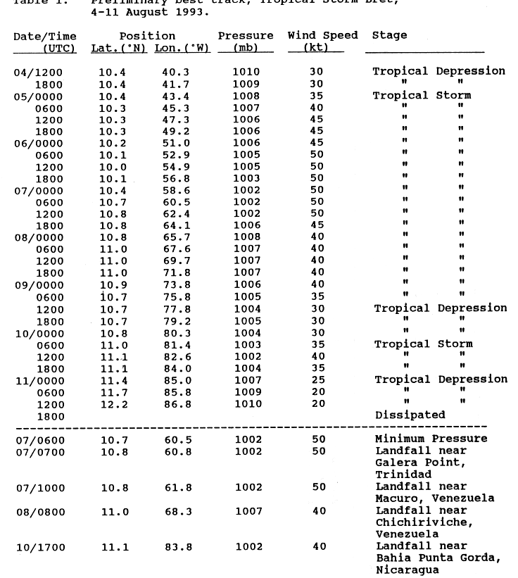
Tropical Storm Bret originated from a tropical wave—a westward-tracking low-pressure area—that crossed the coast of Africa on August 1, 1993. Throughout its journey across the open Atlantic, the wave retained an impressive cloud structure with an area of deep convection. By August 4, the associated thunderstorm activity consolidated and organized into curved rainbands. The National Hurricane Center (NHC), noting the improving structure and sufficient support from Dvorak intensity estimates, reassessed the wave as a tropical depression at 1200 UTC that day, the third such system of the annual hurricane season.[1] At the time of its classification, it was located along the 10th parallel north over the central Atlantic, about 1,150 mi (1,850 km) west-southwest of the Cape Verde Islands. With a very dominant and resilient high-pressure area to its north, the depression continued moving due westward at an unusually low latitude for most of its existence.[1][2]
The depression remained within a region of weak upper wind shear over the following hours, allowing for steady strengthening.[3] At 0000 UTC on August 5, the NHC upgraded the system to a tropical storm and named it Bret, as Dvorak estimates increased and satellite imagery depicted a defined circulation pattern with favorable outflow over the center.[4] The storm accelerated to a fast forward speed of 20–25 mph (30–40 km/h), which it maintained for the next four days while south of the strong high pressure.[1] Closing in on the Windward Islands, Bret began to develop an irregular central dense overcast—an area of thick clouds covering the storm center—and strengthened to peak winds of 60 mph (95 km/h) on August 6.[5] Though the dense overcast became briefly displaced, strong thunderstorms refired over the inner core; a reconnaissance flight into the storm found that the central pressure had dropped to a minimum 1002 mbar (hPa; 29.59 inHg) at 1800 UTC.[1] From that point on, the storm's proximity to the South American mainland and increasing wind shear prevented any additional strengthening.[6]
Bret's center passed between the islands of Trinidad and Tobago near peak intensity on August 7, brushing the northern coast of Trinidad around 0800 UTC.[1] Only three hours later, it briefly came ashore near the town of Macuro in Sucre.[7] Hugging the Venezuelan shoreline, Bret began to deteriorate slowly over the following day as its circulation interacted with high terrain farther inland.[8] It made a second landfall on Venezuelan soil near Chichiriviche, Falcón, around 0800 UTC on August 8 before traversing the extreme southern Gulf of Venezuela and moving near the town of San Rafael del Moján, Zulia.[7] After entering Colombia on August 9, Bret encountered the 18,700 ft (5,700 m) Pico Cristóbal Colón mountain, which severely disrupted the cyclone's vertical air column. By 0900 UTC that day, it exited the coast of Cartagena and emerged over the southwest Caribbean Sea as a tropical depression with a faint circulation pattern.[8]
Once over water, Bret regained a band of strong thunderstorms as its upper-level environment turned increasingly anticyclonic, providing favorable outflow. It restrengthened into a tropical storm by 0600 UTC on August 10, about 160 mi (260 km) east of the southern Nicaragua coast. Bret slowed slightly as it neared the shoreline, making landfall near Punta Gorda that same day around 1700 UTC, with winds of 45 mph (70 km/h). Inland, the storm veered toward the west-northwest and slowly began to deteriorate; Bret lost its status as a tropical cyclone upon arriving at the Pacific coast of Nicaragua around 1800 UTC on August 11, at which point its surface circulation had dissipated. The NHC continued to monitor the remnant cloud system in the northeast Pacific for several days, which alternated between a westward and west-northwestward track at sea until it regenerated into a tropical depression early on August 15.[8] Upgraded to a tropical storm later that day, the cyclone was renamed Greg and continued to mature steadily over the course of several days, eventually peaking in strength as a 130 mph (215 km/h) Category 4 hurricane on August before finally becoming untraceable on August 28.
Caribbean edit
Upon Bret's formation, a tropical storm warning was issued for Trinidad and Tobago. The federal government opened emergency shelters and advised its residents to take necessary precautions.[9] Stores and business closed early after locals had stocked up on life supplies. Army troops were deployed in Port of Spain to avert looting.[10] Officials suspended flight and port operations, and non-essential workers were evacuated from offshore drilling rigs.[9]
Bret passed between the islands as a minimal tropical storm on August 7, with the center moving just over northern Trinidad. Precipitation from the storm peaked at 4.37 in (111 mm); sustained winds of up to 44 mph (70 km/h) were recorded.[11] Its brisk winds and rains triggered scattered power outages, affecting about 35,000 customers in the northeastern region.[10] Flooding and downed trees caused minor property damage in southern Trinidad and central Tobago.[9] The flood waters further devastated local crops, resulting in losses of more than TT$4 million (US$730,000). Infrastructural damage due to inaccessible roads and bridges totaled TT$979,000 (US$179,000).[12] To the north on Grenada, a weather station reported sustained winds of no more than 37 mph (59 km/h), with gusts to 45 mph (85 km/h). A ship known as the Lady Elaine anchored offshore south Grenada near Hog Island reported slightly higher winds of 45 mph (75 km/h).[13]
As the storm paralleled the coast of Venezuela, it brushed Isla Margarita with gusts of up to 53 mph (85 km/h).[13] Tropical storm warnings were issued for the Dutch islands of Aruba, Bonaire, and Curaçao.[14] Passing 70 mi (110 km) to the south, Bret brushed Curaçao with tropical-storm-force winds and light precipitation.[15] A peak wind of 48 mph (77 km/h) was recorded at a local weather station, though strong onshore breeze averaged 30 to 35 mph (45 to 55 km/h). The winds produced rough surf with wave heights of up to 4.9 ft (1.5 m), severely disrupting the coral reef along the south shore. In particular, elkhorn (Acropora palmata) and fire coral (Millepora complanata) received extensive to their structures. Of the coral reefs, those in shallow waters were worst affected; considerable damage also occurred to pillar coral (Dendrogyra cylindrus), which typically grow at depths of less than 16 ft (5 m) below water.[16] In addition, nearby Bonaire experienced gusts to gale force during the passage of the storm.[17][18]
References edit
- ^ a b c d e Pasch, Richard J. (1993-11-22). Tropical Storm Bret (Preliminary Report). National Hurricane Center. p. 1. Retrieved 2013-06-06.
- ^ "Marine Weather Review". Mariners Weather Log. 38 (1). United States Department of Commerce: 73. Winter 1994.
{{cite journal}}:|chapter=ignored (help) - ^ Rappaport, Edward N.; Cobb, Hugh D. (1993-08-04). Tropical Depression Three Discussion Number 1 (Report). Storm Wallet for Atlantic Tropical Storm Bret (1993). National Hurricane Center. Retrieved 2013-05-18.
{{cite report}}: External link in|series= - ^ Avila, Lixion A. (1993-08-04). Tropical Storm Bret Discussion Number 3 (Report). Storm Wallet for Atlantic Tropical Storm Bret (1993). National Hurricane Center. Retrieved 2013-05-18.
{{cite report}}: External link in|series= - ^ Mayfield, Max (1993-08-06). Tropical Storm Bret Discussion Number 8 (Report). Storm Wallet for Atlantic Tropical Storm Bret (1993). National Hurricane Center. Retrieved 2013-05-18.
{{cite report}}: External link in|series= - ^ Avila, Lixion A. (1993-08-06). Tropical Storm Bret Discussion Number 11 (Report). Storm Wallet for Atlantic Tropical Storm Bret (1993). National Hurricane Center. Retrieved 2013-06-06.
{{cite report}}: External link in|series= - ^ a b Pasch, Richard J. (1993-11-22). Tropical Storm Bret (Preliminary Report). National Hurricane Center. p. 7, table 1. Retrieved 2013-06-06.
- ^ a b c Pasch, Richard J. (1993-11-22). Tropical Storm Bret (Preliminary Report). National Hurricane Center. p. 2. Retrieved 2013-06-06.
- ^ a b c "Trinidad and Tobago Tropical Storm Bret Aug 1993 UN DHA Information Report 1". ReliefWeb. August 7, 1993. Retrieved April 18, 2011.
- ^ a b Associated Press (1993-08-08). "Tropical storm hits Trinidad and Tobago". Indiana Gazette. Indiana Printing and Publishing. Retrieved 2011-09-24.
- ^ Daniel, C. B.; Maharaj, R.; De Souza, G. (2002). "Tropical Cyclones Affecting Trinidad and Tobago, 1725 to 2000". Trinidad and Tobago Meteorological Service. p. 8, 12. Retrieved 2011-09-21.
- ^ Edwards, Joslyn R. "Disaster mitigation for hospitals and other health care facilities in Trinidad and Tobago" (PDF). p. 17. Retrieved 2011-09-27.
- ^ a b Pasch, Richard J. (1993-11-22). "Tropical Storm Bret Preliminary Report (Page 3)". National Hurricane Center. Retrieved 2011-09-21.
- ^ Lawrence, Miles (1993-08-06). "Tropical Storm Bret Advisory Number Nine". National Hurricane Center. Retrieved 2011-09-21.
- ^ "Hurricanes and Tropical Storms in the Netherlands Antilles and Aruba" (PDF). Meteorological Service of the Netherlands Antilles and Aruba. p. 28. Retrieved 2011-09-20.
- ^ Van Veghel, Manfred L. J.; Hoetjes, Paul C. (1995). "Effects of Tropical Storm Bret on Curaçao reef" (PDF). Netherlands Antilles Coral Reef Initiative. Retrieved 2011-09-20.
- ^ Meyer, David L.; Bries, Jill M.; Greenstein, Benjamin J.; Debrot, Adolphe O. (2003-09-12). "Preservation of in situ reef framework in regions of low hurricane frequency: Pleistocene of Curaçao and Bonaire, southern Caribbean" (PDF). Lethaia. Retrieved 2011-09-21.
- ^ Mayfiel, Max (1993-08-08). "Tropical Storm Bret Advisory Number Sixteen". National Hurricane Center. Retrieved 2011-09-21.
Venezuela: 1 234 5678 Aftermath: 1234567
Reason for higher death toll: http://cidbimena.desastres.hn/docum/ops/libros/manejologistico.pdf