- see also User:Huldra/Morris-list
Khalidi, 1992, errata: edit
As any book plowing new fields, Khalidi, 1992, has its errata...and missed things.. I now see some mistakes are making their way into other books; therefore I start noting them here:
- p. 12-13: missed the 1596 census on Al-Ghabisiyya.
- p. 18: where do the 1945 numbers come from? See Talk:Khirbat Jiddin
- p. 27: missed SWP p149 under Al-Nabi Rubin, Acre
- p. 43: under Arab al-Safa: Guerin-ref.: [Guérin 1874:49] should be [Guérin 1875:49] ...except that isn´t for Arab al-Safa at all, it is for Saffa, Ramallah!!
- p. 45: under Al-Bira, Baysan ..the leStrange quote, p.423. There are 3 different Al-Birahs. BUT: "strong fortress and vast lands" is between Halab (Aleppo?) and "Greek Fortresses" .. See Talk:Al-Bira, Baysan.
- p. 46: [Burckhardt 1822:842]...should be [Burckhardt 1822:342]...se under Danna ..(and Burckhardt, 1822, doesn´t have as much as 842 pages...)
- p. 56: for Al-Murassas: [Burckhardt 1822:842-43]...should be [Burckhardt 1822:342-43].
- p. 60: for Sirin, Baysan: writes that there were 22 inhabitants in 1596, when HA gives 45 households (45x5.5 =247.5 persons)
- p.75: [Robinson, 1841, I: 201-202], ..should be p.297ff? (where there is a lot about Elusa)
- p.80: Arab Suqrir, missed *a lot* of history, including ARP & SWP
- p. 121: see Talk:Revaha
- p. 123: see Talk:Al-Khisas, Gaza
- p. 189: see Talk:Khirbat al-Sarkas
- p. 216: Robinson -ref should be p. 352-353, *not* p.252-253. See Talk:Deir al-Dubban
- p. 240: see Talk:Fajja
- p. 247: wrong HA!! see User:Huldra/HA#p.119, User:Huldra/HA#p.156
- p. 287: partially wrong 1931 data, see Talk:Dayr Rafat
- p. 298 Al-Jura, Jerusalem typo: "East of the village lay Khirbat Sa’ida" should be "West of the village, etc"
- p. 381: see Talk:Hadatha
- p. 398: see Talk:Al-Mansura, Ramle
- p. 404: see Talk:Qatra
- p. 518: see Talk:Hadatha
- p. 521: ref to [Burckhardt 1822:250] should be [Robinson, 1856, p.396]???? See: Talk:Hittin NB: Petersen, 2002, p.150 also notes the Burckhardt-ref; probably he only took it from Khalidi.
- p. 532: ...[SWP (1881) II:362]....should probably be: [SWP (1881) I:362]
- p. 542: ...khan is *north* of the palace (not *south*), see Talk:Khirbat al-Minya, Tabgha,
- p. 558, under Miska, cites "Nelson, Napoleon in Egypt, cited in D[=al-Dabbagh, Mustafa, 1972-90] 3/2:386".......however, I cannot find *any* book written by a "Nelson" named "Napoleon in Egypt"! However, there are several books *about* Nelson and Napoleon in Egypt....(including Christopher Lloyd, (1973): "The Nile Campaign. Nelson and Napoleon in Egypt"..where there is nothing about Miska that I can find.. but there is the info (p.78) that the source on Klebers campaign is M. Vertray, 1899, The French Army in Egypt (trans. George Lionel B. Killick) --->should be checked when it comes online)
- Khalidi also gives Napoleon-related info on p.193 Tantura (source given: Harold Christopher, Napoleon in Egypt. pp. 416-448, cited in D 7/2:608), p. 559 Qaqun (no source given), p.562 Umm Khalid (no source given). ... & I cannot find a "Harold Christopher, Napoleon in Egypt", however, there is a "Herold, Christopher (1962), Bonaparte in Egypt", ..is this it?? --->will check.
- http://gallica.bnf.fr/ is a large source of free books (maps, etc) in French.
- p. 566, under Khirbat al-Zababida he gives SWP II, p. 229 as ref. But that is Zababdeh. See Talk:Khirbat al-Zababida
- p. 610: "Hütteroth, Wolf-Deiter".. should be "Hütteroth, Wolf-Dieter"
Morris & Khalidi-differences: edit
- see User:Huldra/Morris2-list, as noted there: Morris writes that he gives the settlement name, followed "by the former Arab Name of the site or nearest or nearest site..", this while Khalidi actually gives land-ownership instead.
- Ayn Ghazal: disagree about Ein Ayala: is it on village land, or not?
- Daliyat al-Rawha': disagree about Ramot Menashe: on village land, or not?
- Kfar HaNagid: Morris writes it is on the land of Al-Qubayba, Ramla...Khalidi (p.408, 423) on the land of Yibna (near Al-Qubayba, Ramla )
Petersen & Khalidi-differences: edit
- Arab Suqrir: Khalidi writes that Nir Gallim and Ashdod is on the village land, while Petersen writes that Bene Darom is on the site
Petersen, 2001, errata, or missed stuff: edit
- p.124: typo: under Bayt Jiz: "SWP, II, 108" should be: "SWP, III, 108"
- p.146: see Talk:Hamama
- p.150: also notes the mistaken Burckhardt-ref: [Burckhardt 1822, 250]; probably he just took it from Khalidi, p521. (see: Talk:Hittin#Roots)
- p.180: under Jaljulia: does not note the al-'Ulaymi -refs. Typo: "SWP II, p. 288-299" should be: "SWP II, p. 288-289"
- p.200: typo: the ref.:"Khalidi 1992, 389-340" should be "Khalidi 1992, 389-390"
- p.248: for Qabu, missed(?) the SWP p.100-ref (mentioned in Pringle.) (Or did he not think it relevant?) On the other hand: the al-'Ulaymi Sauvaire (ed) 1876 ref; 101157 do not look relevant
- p.249: for Qalansawe : the al-'Ulaymi Sauvaire (ed) 1876 ref; index, 39 does not look relevant
- p. 273: see Talk:Al-Sarafand
- p.287: writes that Guérin visited Arab Suqrir in the 1870s...but as the book he refers to ("Judee, II") is published already in 1869...that should probably be "1860s".
- p.288: Gives "Palmer, 1881, p.281" as ref. for Arab Suqrir...but I simply cannot find anything relevant to Arab Suqrir on that page? -However, it might be a ref. to a spring in the vicinity (-->check map).
- No, that page is for map 17 but Arab Suqrir is on map 16; search for "Sukereir" to see relevant mentions in that book. SWP does not name this place as a village, nor do mandate-era maps. There was a ruin "Khirbet Sukereir" shown though. I think "Arab Suqrir" was a bedouin tribe. Zerotalk 03:52, 25 April 2010 (UTC)
- p.289: under refs for "Sukriyya (Khirbat)": "ARP, II, 139-140", probable typo; cannot find anything relevant on those two pages. Correct is proabably: "ARP, II, 439-440"
- p.298: under Tayibe, see talk
- lists Guérin Samarie, I 206-207 BUT: .. this is Taybeh, West Bank. (according to index, al-Bireh and Beitin is in that area)
- ..the Israeli Tayibe seem to be: Guérin Samarie, II 352 (which is close to Qalansawe)
- p.298: Also, the: Clermont-Ganneau, ARP, II, 280, 293, 295-298, 490 -all refs are for Taybeh, West Bank, except p.490: nada! (it is mentioned in the idex, but not on the page!)
- p.307: major mix-up between Tira, Israel and Al-Tira (Ramla). See Talk:Tira,_Israel
- p.327: typo: ref to " Tabula Imperium Romani" should be "Tabula Imperii Romani"
- p.335: a reference to "Schumacher, G" (1887): "Recent discoveries -Notes and news from Galilee", PEFQS, October, p.159-175 ....does not exist on those pages. However, on p68ff, p.187ff (and possibly p.24ff) Also [1].
Places of interest, not in Petersen edit
- Magen, Israel, Sheikh Nuran grave
- Note these 4 pictures, taken between 1934-39, presumably the same place (but differently named):
- http://www.loc.gov/pictures/item/mpc2010003333/PP/ Beersheba District. Willi, Sheikh Nouran
- http://www.loc.gov/pictures/item/mpc2010003334/PP/ Beersheba District. Monument to Abu Ghreira
- http://www.loc.gov/pictures/item/mpc2010003335/PP/ Beersheba District. Tel with Wili (NB: corruption of "wely")
- http://www.loc.gov/pictures/item/mpc2010003353/PP/
- Morris, 2004, states as settlement #172 Magen, Israel <--- Sheik Nuran, 1949
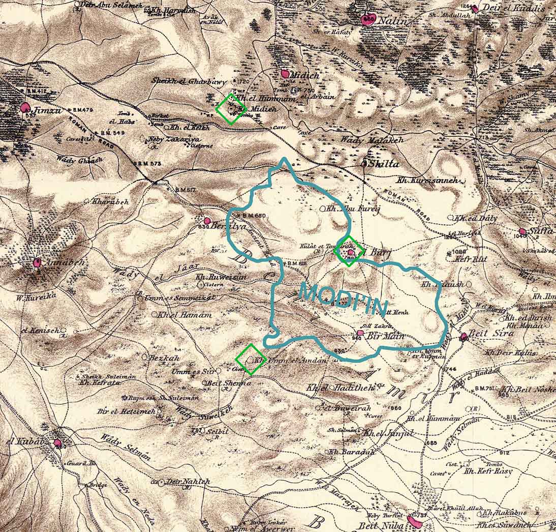
- A tomb in Modiin. It is at the place Sitt Mena ("Lady Mena") partly obscured by the N of the blue "MODI'IN" on the same map. I can't read it enough to say more, but something about five sisters. Better ask Ynhockey. Maybe SWP explains Sitt Mena. Zerotalk 05:03, 27 April 2010 (UTC)
- Ok, great, thanks! I did ask Ynhockey about where it was, and he did not know. This means that it is not in Petersen; he has maps showing where the different places he discusses are, and the Modin-area is quite blank. And since I don´t have an literature about the structures, then I´m not planning to start any articles on them. The way I read it (through translator!..just guessing) was that one version told of the Shia refugees after the battle of Kerbala? There is, or rather, *was*, an important Shia shrine, "Maquam Sitt Sukayna", for Sakinah bint Husayn, a daughter Husayn ibn Ali, standing south of Tiberias. It is now used for dumping rubbish. There were two Mamluk inscription on the Tiberias shrine, both are now gone from the place, (one dated from 1295), one inscription is now in Rockefeller Museum. Before 1948, this place by Tiberias apparently was a place of pilgrimage, but afterwards...the young ladies remains apparently magically moved to Damascus, to everyones satisfaction...so that is where now the Iranians pilgrims go! (Seriously; you couldn´t make this up..) Huldra (talk) 11:28, 27 April 2010 (UTC)
- Even better: "Maquam Sitt Sukayna" has apparently recently been renovated...as it is being reinvented as the grave of Rachel, wife of Akiva ben Joseph!! http://commons.wikimedia.org/wiki/Category:Tomb_of_Rachel_in_Tiberias. Petersen has a lot about the place...an article should really be started..Huldra (talk) 01:44, 8 October 2011 (UTC)
- A tomb in Modiin. It is at the place Sitt Mena ("Lady Mena") partly obscured by the N of the blue "MODI'IN" on the same map. I can't read it enough to say more, but something about five sisters. Better ask Ynhockey. Maybe SWP explains Sitt Mena. Zerotalk 05:03, 27 April 2010 (UTC)
Zertal errata: edit
- No 3, p. 356: “yet smaller [in comparison to Nuzlet esh Sharqiyeh, A.Z.], should be An-Nazla al-Gharbiya
Places described in Petersen, not mentioned in Khalidi, and with no wp-article: edit
Bassum (Khirbat) edit
- pp.111-112: Bassum (Khirbat), Petersen gives the location as 32.44N/35.28E
- picture: nice mosque, still standing
- reported in the 1920s that it was deserted
- Guérin, M. V.: (1880): Description Géographique, Historique et Archéologique de la Palestine. Galilee, I, p.265
- Palmer, E. H. (1881): The survey of Western Palestine: Arabic and English name lists collected during the survey by Lieutenants Conder and Kitchener, R. E. Transliterated and explained by E.H. Palmer. (p.128)
- Robinson, Edward, Eli Smith (1841): Biblical Researches in Palestine, Mount Sinai and Arabia Petraea: A Journal of Travels in the Year 1838a, Published by Crocker & Brewster, Item notes: v. 3 (p.237; he describes the place as "ruined")
- Conder, Claude Reignier and H.H. Kitchener (1881): The Survey of Western Palestine: memoirs of the topography, orography, hydrography, and archaeology. London:Committee of the Palestine Exploration Fund. vol 1 (p.365 -366 )
- Grootkerk Gazetteer, pp320-321 gives the modern location as Kirbet Ivzam (1954/2378) and older names Kh. Bessum, Kh. Bessoum, Ayn Bassem, Kh. Buzum; and a biblical identifcation Alon Be Za'anim (Josh. XIX-33). Zerotalk 13:21, 18 April 2010 (UTC)
- Can't find it in Hutteroth. That book is very annoying, no index and map with no names but just codes like Z13, P43. Zerotalk 13:33, 18 April 2010 (UTC)
Malaha, with nearby maqam sheikh Bureik: edit
Nabi Bulus edit
Nabi Dahi edit


- Petersen, p. 226 (nice picture: small shrine)
- 32.37N/35.21E, = 1832.2249
- visited by Evliya Çelebi:
The shrine of Shaykh Dahi, one of the Noble companions of the Prophet, is on the mountain north of these villages. He is buried under a high dome. The mausoleum has a[n appointed] keeper and waqfs assigned to it. The belongings of the inhabitants living around the shrine are frequently deposited within. Nobody ever dares to appropriate such goods. In fact it is a high[ly honoured] shrine[1]
- When Edward Robinson visited the area in 1838, an elderly man, "professed to be the keeper of the Weli of Duhy, and offered his services as a guide to the mountain, which he said was often visited by the monks"[2]
- Tawfiq Canaan, 1927, 290
- Guérin, 1880, Galilee, I, 114-p.115
- Palmer, 1881, 166
- Wilson, 1884, II, 41 (Picture! we could use this(?)..though the pic.in Petersen and commons shows that the shrine has been repaired since then.)
- SWP, II, 85 (map IX) (is it "Kuryet ed Duhy"?)
- Kuryet ed Duhy is probably a reference to Ed Dahi (Kuryet meaning "village"; see also p. 123 of SWP which translates it as "village of Duhy"; compare with p. 131 on Neby Duhy, translated as "prophet of Duhy"). Conder also transliterates Nabi Dahi as Nebi Dhahy in his book Palestine. Tiamuttalk 22:03, 1 May 2010 (UTC)
- Yitzhaki, 1986, 14, 260
- Petersen, 226: "The shrine is still venerated by Palestinians in the area, although it has been fenced off to prevent vandalism."
- It is on a very large hill with two peaks about 800m apart east-to-west. The hill is called "Jabal ad Dahi (Little Hermon)" on a 1939 survey map. On the western peak is Nabi Dahi (1939 map) = Neby Duhy (PEF map). About 300m down the western peak in the NW direction is Ad Dahi (1939 map) = Kuryet Duhy (PEF map).
- Morris p177, says "al Dahi" depopulated at orders of Arab irregulars (but doesn't list it as a depopulated village, I guess because the population was temporary, see Nein which is 1km north)
- I assume he doesn´t list it as depopulated, because it wasn´t? See Ed Dahi.
- Census 1931, "Ed Dahi" p73: 16 occupied houses, 87 Muslims (38 boys and 49 girls).
- Should go into the Ed Dahi-article?
- Yes, right. That article is a mess. I don't buy the Zoabia thing; I suspect vandalism and deleted similar claims from a few other articles. Btw, the Jacotin map shows a village in this place labeled "Village". It is in the right location and sits on the side of the mountain just like Ed Dahi. Zerotalk 04:12, 30 April 2010 (UTC)
- The articles (with that info) were started by User:Number 57, based on the (unsourced) Hebrew Wikipedia. ALSO: some of the Israeli sources are, eh, somewhat "less than reliable". (Typically: Alma, Israel where a WP:RS source tells us that the Palestinian village of Alma (mentioned in Hütteroth)..was "founded in the 19th century by Algerian Muslims" Yeah, right.) --Huldra (talk) 12:13, 30 April 2010 (UTC)
- Khalidi's report of Hutteroth greatly disagrees with what is there and I can't see how to explain it. I replaced the text. The number of "bachelors" is unusually high but there might have been some explanation (eg. a military barracks).
- The articles (with that info) were started by User:Number 57, based on the (unsourced) Hebrew Wikipedia. ALSO: some of the Israeli sources are, eh, somewhat "less than reliable". (Typically: Alma, Israel where a WP:RS source tells us that the Palestinian village of Alma (mentioned in Hütteroth)..was "founded in the 19th century by Algerian Muslims" Yeah, right.) --Huldra (talk) 12:13, 30 April 2010 (UTC)
- Google maps [2] shows a locality "Dahi" at the site (the one down the hill a bit), but I don't know its legal status. Also at amudanan: [3] and the name of the hill is shown as Givat Moreh. Also see Moreh.
- see also: http://he.wikipedia.org/wiki/גבעת_המורה
- "Neby Duhy is a similar conical peak north-east of the last, and has a domed shrine on the top. The legend attached states that the bones of the saint were carried there by his dog, which reminds us of the Parsee veneration of dogs (the companions of Mithra), who to the horror of Greek writers were permitted to devour the bodies of the most noble among the Persian fire-worshippers." — PEF Quarterly Statment, April, 1881, p84. I've seen this story about the dog before, do you have a good source? Zerotalk 15:02, 2 May 2010 (UTC)
References edit
Bibliography edit
- Canaan, T (1927): Mohammedan Saints and Sanctuaries in Palestine.
- Conder, Claude Reignier and H.H. Kitchener (1881): The Survey of Western Palestine: memoirs of the topography, orography, hydrography, and archaeology. London:Committee of the Palestine Exploration Fund. vol 2
- Conder, Claude Reignier (1889): Heth and Moab; Explorations in Syria in 1881 and 1882 (p.309)
- Guérin, M. V.: (1880): Description Géographique, Historique et Archéologique de la Palestine. Galilee 1 part.
- Palmer, E. H. (1881): The survey of Western Palestine: Arabic and English name lists collected during the survey by Lieutenants Conder and Kitchener, R. E. Transliterated and explained by E.H. Palmer.
- Petersen, Andrew (2002): A Gazetteer of Buildings in Muslim Palestine: Volume I (British Academy Monographs in Archaeology)
- (1881): Quarterly statement - Palestine Exploration Fund (p.84)
- Robinson, Edward, Eli Smith (1860): Biblical Researches in Palestine and the Adjacent Regions: A Journal of Travels in the Year 1838, Published by Crocker & Brewster, Item notes:v.2
- Wilson, Charles Williams, ed. (1881, 1884): Picturesque Palestine, Sinai and Egypt. vol 2 of 4.
Nabi Kifl edit
Nabi Thari edit
- Only 500m south of Kfar Sirkin on 1939 map. 32:03:00N, 34:55:40E
- see: List of burial places of Biblical figures. (Search for "Asher"). Unsourced, though.
Bibliography edit
- Canaan, T, 1927, p.296:
- Conder, Claude Reignier and H.H. Kitchener (1881): The Survey of Western Palestine: memoirs of the topography, orography, hydrography, and archaeology. London:Committee of the Palestine Exploration Fund. vol 2 p.269
- Dauphin p818 says: "Sur tertre artificiel bas, fondements de bâtiments; amoncellements de moellons; blocaille; tambours de colonnes de marbre; pavement de mosaïque grossière; basin creusé dans roc; pressoir construit et plâtré. Eglise en partie fouillée par J. Kaplan en 1950, pavée de mosaïque polychromes aux motifs géométriques. A l'E de l'église, murs (ép. 1,60 m) de pierres de taille (fort?). Céramique byzantine. Autour du tall, tessons, monnaies et détritus d'un four de potier." Zerotalk 14:37, 22 April 2010 (UTC)
- Guérin, M. V.: (1875): Description Géographique, Historique et Archéologique de la Palestine. Samarie,vol II, p. 389
- Mayer et. al. , 1950, p. 34-36
- Palmer, E. H. (1881): The survey of Western Palestine: Arabic and English name lists collected during the survey by Lieutenants Conder and Kitchener, R. E. Transliterated and explained by E.H. Palmer. p.217
- http://www.palestineremembered.com/GeoPoints/Nabi_Thari_4080/index.html#Statistics
- Tsafir (p195) gives a current name: Khirbet Sheeri or She'eri (143/163), calls it a church. Gives refs "Isserlin, PEQ(1950), p99" and "A Ovadiah, Corpus of the Byzantine Churches in the Holy Land, Bonn, 1970, number 145." [Sounds a good source, is it available?]
- Petersen, pp. 232-233. Mamluk or early Ottoman shrine.
- According to Petersen:: "The identity of Nabi Thari is not certain, although Canaan (1927, p.295) equates him with Asher, son of Jacob. In 1996 excavations were carried out in the immediate vicinity of the shrine, these revealed substantial buildings associated with pottery datable to the late Mamluk or early Ottoman period. (Fanny Vito, pers. comm.). Such a date (i.e. fifteenth or sixteenth centuries) is consistent with architecture of the building, which bears some resemblance to the mosque Abu al-Awn in Jaljuliyya ....The floor level of the interior is nearly 1 m. below ground level suggesting that the shrine is of some antiquity. Before 1948 there was a Qur'anic inscription (Sura 2, V. 256) in the crown of the dome (Mayer et.al, 1950, 35). Unfortunately since then, the dome has more than half collapsed destroying the inscription and exposing the interior to the elements. Although still standing, the building requires urgent conservation."
External links edit
Sukriyya (Khirbat): edit
- Petersen, pp.288-289
- Location: 31.34N, 34.46E, south of Iraq al-Manshiyya
- village of Sukriyya included in waqf established by sultan Quytbay in 1471/1472 C.E.
- ARP II
p.139-140.(I think this is a typo from Petersen, as I cannot find anything relevant on those two pages. p.439-440, on the other hand, are *very* relevant,- Huldra (talk) 01:27, 27 April 2010 (UTC)) - Guérin, 1869, Judee II, p.304
- Palmer, 1881, p.375
- Robinson, 1842, II, p.392-393
- SWP, 1881, III, p.286 but map coords are given incorrectly, should be Hw not Gv (sheet XX).
- Apparently mentioned by Felix Fabri and Al-Muqaddasi, no good cites yet.
- I have hard-copy of: Muqaddasi, 1994: "The Best Divisions for Knowledge of the Regions", ...and of the two Prescott-editions of Fabri (from 1954 &1957). However, those two represent just a small part of Fabri´s work, published in 150 years ago...in Latin!! (And the Latin-books are freely available..) I know; Fabri apparently wrote about glass-works in Hebron (that´s why I bought the Prescott-books)..but ms. Prescott had not included the Hebron-part in any of her two (very readable) books...Huldra (talk) 04:04, 17 April 2010 (UTC)
- Probable mentions here and here. My library has PEQ in hard copy; I'll look next week. Zerotalk 04:32, 17 April 2010 (UTC)
- Hutteroth (Z36,p145) lists "Bayt Daras as-Sugra" at this place with a question mark. No population given. Zerotalk 04:54, 17 April 2010 (UTC)
- Appears as a normal village es Sukkarieh in Atlas von Palaestina und der Sinai-Halbinsel, Carl Zimmerman, Berlin 1850.
- Something strange: As Sukkariyyah appears on the map in Le Strange's book, but as far as I can tell there is no mention of it in the text of the book.
Bibliography edit
- Khalidi, Walid (1992), All That Remains: The Palestinian Villages Occupied and Depopulated by Israel in 1948, Washington D.C.: Institute for Palestine Studies, ISBN 0887282245
- Mayer, L. A., Pinkerfeld, J. and Yadin, Y. (1950), Some Principal Muslim Religious Buildings in Israel, Ministry of religious affairs, Jerusalem. Cited in Petersen (2002)
- Morris, Benny (2004): The Birth of the Palestinian Refugee Problem Revisited, Cambridge University Press ISBN 0521009677
- Petersen, Andrew (2002): A Gazetteer of Buildings in Muslim Palestine: Volume I (British Academy Monographs in Archaeology)