 Deir Qal’a ruins | |
 Shown within the West Bank | |
| Location | Salfit Governorate, West Bank |
|---|---|
| Coordinates | 32°03′30″N 35°02′41″E / 32.05833°N 35.04472°E |
| Grid position | 15435/16275 PAL |
| Type | Roman castle, Byzantine monastery |
| History | |
| Periods | Roman to Byzantine period |
| Cultures | Roman and Byzantine |
| Site notes | |
| Archaeologists | Yizhar Hirschfeld |
| Condition | In ruins |
| Public access | yes |
Deir Qal’a (Deir Kulah; "the monastery of the castle"[1]), is located SSW of Deir Sam'an
History edit

Sherds from the Byzantine and the Byzantine/Umayyad eras have been found here.[3]
Ottoman era edit
In 1838 it was noted as a ruin by Robinson and Smith.[4]
In 1870 Guérin visited, and noted: "At ten past nine we go back down in a westerly direction and then south. After crossing a small valley, we climb, to the south-southwest, a mountain whose banks are bristling with Quercus ilex, carob trees, mastic trees and tall thorny grasses. We reach the summit at nine hours and forty minutes. There, ruins even more considerable than those of Deir es-Sema'an immediately catch my eye. They are called Deir el-Kala'h, (convent of the fortress), so named, because it was a real fortified castle, defended by very thick walls, ditches dug into the rock or very deep ravines.
I first cross several indistinct ruins, then I soon arrive at the remains of a beautiful chapel that measured internally 8 "pas de large sur" 31 long. Preceded to the west by a narthex now completely demolished, it ended, to the east, in a semicircular apse, illuminated in the center by an arched window. A cornice, both simple and elegant, reigned above it and probably circled the building. The northern façade was partly destroyed; the western one is shaved; that of the south is better preserved, at least in its lower foundations. The apparatus of the stones with which this church was built is the average apparatus; They are, moreover, very regular and perfectly flattened. The tiling consisted of small white cubes forming a mosaic; They have long since been disintegrated to make way for tobacco plantations."[5]
"To the east of the chapel stands a tower, which once had two floors and is now crowned from its upper part. It was built with large bossed blocks resting without cement on top of each other and perfectly arranged between them. It is entered through a rectangular door, whose right legs are surmounted by a beautiful monolithic lintel, in the center of which was carved a Maltese cross. This cross is surrounded by a circle itself enclosed in a kind of rectangular frame and flanked by two small triangles.
To the south of the same chapel, two large halls built with ashlars are still partly standing; They were lit by rectangular windows, and one of them is crossed, towards the middle, by arched arcades. They had two floors. The lintel of a second door is likewise adorned, in its centre, with a Maltese cross surrounded by a circle framed by a long rectangle, flanked, on the right and left, by a triangle, all enclosed in a second rectangular frame of larger proportions.
On the lintel of a third door, I likewise observe a Maltese cross, which rests on a semicircle, each of which rests on another semicircle.
Above a fourth door, much higher than the previous ones, and which, to the south, gave entrance into the convent, a cross with equal branches was similarly carved on a lintel 3m, 10 long.
To the west of this door, and separated by a corridor from the two beautiful rooms I have mentioned, we notice the ruins of a pavilion that protrudes in corbelling with machicolations to throw stones or strokes.
Finally, a second square tower, with two floors, measuring 11 steps on each side and pierced with loopholes, attracts my attention on the same side. It is next to a birket partly carved into the rock and partly built with beautiful blocks covered with a very thick cement."[6]
"This basin, into which one descends by thirteen steps, is 14 steps long and as wide.
A second birket, much larger than the previous one, extends next to the first tower I have mentioned. It measures 48 steps long by 15 wide, largely carved into the rock; Where the rock was lacking, it had been built with superb blocks, most of them carved into bosses and very regular. The cement that lined the inner walls has fallen three-quarters. This large pond is now planted with tobacco. It communicated with two other birkets of smaller dimensions and partly dug into the rock at a lower level. These various basins, as well as the ditches made in the rock which, towards the south, border the enclosure, still standing on this side, seem to have been, in principle, excavations made to extract building materials.
What are the memories relating to this beautiful fortified convent, or, if one prefers it, to this fortified castle, which contained within its walls the great chapel to which I have referred? From what time also dates was founded? On the first question, I must confess that neither in the traditions of the country nor in history have I found anything that can teach us anything about it. As for the age of these important buildings, I believe predate the Arab invasion of Palestine. At first glance, the sight of these huge birkets practiced in the rock or built with blocks with bosses very regularly jointed together, the sight also of these beautiful and thick walls built with blocks of the same apparatus resting without cement on top of each other, could suggest that we have before our eyes the remains of a Jewish fortress. But we are forced immediately to abandon this hypothesis, because the great chapel of which I have spoken is so well enclosed in all the buildings that it is impossible to think that it was built after the fact, several centuries after the construction of the towers and walls mentioned above. In addition, most of the doors are still standing, and which do"[7]
"not appear to have been reworked at any later time, are marked with a cross with equal branches, carved in relief on the middle of the monolithic lintel that crowns its right feet.
These crosses and the magnificence of these constructions, which must have cost considerable sums and effort, which must have been made at a time when the Christian religion was very strong in the country, lead us to believe that we have before our eyes a fortified convent dating from the fourth or fifth century of the Christian era. Wandering among the ruins, I came across several shafts of columns that belonged, in all appearance, to the chapel and a capital representing a kind of basket woven up to date, of a very pronounced Byzantine character. In any case, this convent is much earlier than the time of the Crusades, and, if it was reoccupied by the Latins, they must have left it more or less as it had been built several centuries before. Some revisions, however, can be attributed to them, unless, by chance, which is also possible, they are the work of Muslims."[8]
In June, 1873, the PEF's SWP visited and noted about Deir Kulah:
"Perhaps the finest and best preserved of the ruined monasteries in Palestine, situate in a very strong position on the edge of a precipice, and protected by deep and rugged ravines on all sides except the east, on which side the quarries form a sort of ditch. A narrow path leads up on the west from the small plain of
Deir Ballut, passing under a projecting turret on brackets. The building, being on the side of the hill, is on three levels, east and west.
The principal remains are those of the church, and of a great hall (apparently the refectory) south of it, with a square tower on the east at a higher level ; and a huge birkeh north of the tower with two smaller again north."[9]
Outer Walls edit
"The ashlar is of fine proportions; the stones all drafted with a draft 10 inches broad, and 2 to 3 inches deep ; the raised face is rudely dressed, and the draft is irregularly cut. The corner stones are in some cases 6 feet long and 3 feet high, but the average is about 3 feet by 2 feet. The retaining- wall on the west is 20 feet high, and the turret 14 feet square and 6 feet high ; the top on a level with the floor of the enclosure within. The masonry of this wall resembles in appearance that of Justinian's fortress on Gerizim. (See Jebel et Tor, Sheet XI., Section H.)."[10]
The Church edit
"...measures 80 feet long by 23 feet wide inside, including a narthex of 12 feet at the west end. The walls are standing to a height of 16 feet to 18 feet. The east apse, 18 feet diameter, has a window in it, the sill 7 feet from the floor. A cornice runs round the apse 10 feet from the floor, and is remarkable, because it is bent so as to follow the line of the semicircular arch of the window. This feature resembles the cornice of the Golden Gate at Jerusalem, and that of the church of Kalb Louseh, ascribed by M. du Vogue to the sixth century.
On the right of the apse a cross is sculptured, standing on a globe beside the cornice; and a line of ornamentation running up the wall exists above the cornice, with debased classic mouldings containing the cross on some of the bosses. The cornice is 18 inches high, and this band of sculpture is 23 inches wide."[11]
-
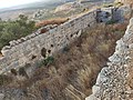
![Machicoulis at Deir Qala[12]](//upload.wikimedia.org/wikipedia/commons/thumb/e/ef/Deir_Qala_0.png/120px-Deir_Qala_0.png) Machicoulis at Deir Qala[12]
Machicoulis at Deir Qala[12] -
![The church: the east apse, with the semicircular arch of the window[11]](//upload.wikimedia.org/wikipedia/commons/thumb/9/94/Deir_Qal%E2%80%99a%2C_no2.png/120px-Deir_Qal%E2%80%99a%2C_no2.png)
-
![The church: the cornice, and the cross, standing on a globe[11]](//upload.wikimedia.org/wikipedia/commons/thumb/2/25/Deir_Qal%E2%80%99a%2C_no3.png/108px-Deir_Qal%E2%80%99a%2C_no3.png)
![Machicoulis at Deir Qala[12]](/wiki/File:Deir_Qala_0.png)
![The church: the east apse, with the semicircular arch of the window[11]](/wiki/File:Deir_Qal%E2%80%99a,_no2.png)
![The church: the cornice, and the cross, standing on a globe[11]](/wiki/File:Deir_Qal%E2%80%99a,_no3.png)
The Hall edit
"...is separated by a court 42 feet wide from the church and measures 34 feet in length by 26 feet in breadth, divided into two aisles by two piers supporting three semicircular arches 7 feet span. Above these arc five windows, and in the south walls of the hall are also five windows in the north wall three windows, and a door surmounted by a flat lintel with a low relieving arch above it. The lintel is 8 feet 4 inches by 2 feet 9 inches; the arch has seven voussoirs, and a very narrow keystone, the haunch-stones broad. On the lintel is a winged tablet, with a Greek cross in a circle upon it.
West of the hall is a chamber, with a roof 12 feet from the floor. The hall had a roof at not less than 20 feet from the floor; the chamber was 8 feet wide, and equal in length to the width of the hall; on the south a window; on the north a window and a door. The door has over it in situ a lintel about equal to the last, with a relieving arch of five voussoirs. On the lintel a Latin cross standing on three hemispheres, the conventional sign of Calvary.
A third doorway leads into other chambers, of which there seem to have been five in all, a total of 47 feet by 26 feet inside. The third doorway is surmounted by a flat lintel, 2 feet 4 inches high, 7 feet 1 inch long, with a tablet and cross in a circle as on the first. Beyond these chambers is another chamber 26 feet square, with five windows on the south wall. Thus, the total external length of these buildings east and west is 128 feet by 32 feet external breadth. The whole of the masonry is of good ashlar, not drafted. Only one column base was found fallen in the ruins."[13]
-
![The Hall: a lintel, on a winged tablet, with a Greek cross[11]](//upload.wikimedia.org/wikipedia/commons/thumb/3/37/Deir_Qal%E2%80%99a%2C_no4.png/120px-Deir_Qal%E2%80%99a%2C_no4.png)
-
![The Hall: lintel B, with a Latin cross standing on three hemispheres, the conventional sign of Calvary[14]](//upload.wikimedia.org/wikipedia/commons/thumb/a/a0/Deir_Qala_5.png/120px-Deir_Qala_5.png) The Hall: lintel B, with a Latin cross standing on three hemispheres, the conventional sign of Calvary[14]
The Hall: lintel B, with a Latin cross standing on three hemispheres, the conventional sign of Calvary[14] -
 The Hall: lintel B, in situ, 2015
 -
![The Hall: another lintel, on a winged tablet, with a cross[14]](//upload.wikimedia.org/wikipedia/commons/thumb/b/b5/Deir_Qala_6.png/120px-Deir_Qala_6.png) The Hall: another lintel, on a winged tablet, with a cross[14]
The Hall: another lintel, on a winged tablet, with a cross[14] -
![The Hall: base of a column[14]](//upload.wikimedia.org/wikipedia/commons/thumb/f/f0/Deir_Qala_7.png/120px-Deir_Qala_7.png)
![The Hall: a lintel, on a winged tablet, with a Greek cross[11]](/wiki/File:Deir_Qal%E2%80%99a,_no4.png)
![The Hall: lintel B, with a Latin cross standing on three hemispheres, the conventional sign of Calvary[14]](/wiki/File:Deir_Qala_5.png)

![The Hall: another lintel, on a winged tablet, with a cross[14]](/wiki/File:Deir_Qala_6.png)
![The Hall: base of a column[14]](/wiki/File:Deir_Qala_7.png)
The Tower edit

"The Tower is 30 feet square outside, with walls 4 feet thick. The entrance is on the north, with a lintel-stone 6 feet 10 inches by 2 feet 4 inches, and a relieving arch formed by cutting out the under side of two stones. On the lintel is a tablet, with large wings, and on this a cross in a circle. A drafted stone occurs in the wall to the left. The floor of the tower is 14 feet above that of the chapel. The roof still remains, built of rubblework, with a tunnel vault."[14]
The Birkeh edit
"...measures 111 feet north and south by 34 feet breadth. It is cut in rock, and 15 feet deep; there is a sloping cutting at the sides, evidently to support the haunch-stones of a vault over it. The sides are in places built up to a level with rubble. North of this great tank are two smaller ones, 38 feet north and south, and respectively 18 feet and 9 feet wide. All these tanks are lined with a hard brown cement full of pottery."[14]
-
 Part of the birkeh; a large water reservoir
 -
 Part of the birkeh
 -
 Part of the birkeh; notice the lining with a hard brown cement


Other edit


"A row of cells seems to have run along the eastern wall of the monastery, which is built above the main birkeh ; thus the total area of the monastery must have extended over 180 feet east and west by 200 feet north and south, or about the same area enclosed by Justinian on Gerizim ; two crosses were found on the inside of the eastern wall, well cut, one with a circle round it.
No masons' marks occur on the stones, but on the outside of the south wall of the chapel several marks are rudely cut, two or three on one stone. These are probably the tribe marks of wandering Arabs, as at Sebbeh. (Sheet XXVI.) They are as shown. (See Khurbet Kurkush and Mokata 'Abud.)
The joints are well and firmly laid in the masonry. No pointed arches were found. The vaults are all tunnel form, and not groined. Rubble is used to form the core of the walls. The masonry in the interior is smooth and not drafted. All the characteristics of Crusading work are absent.
There are two caves on the west, one about 30 feet long, the other 20. The path ascends by steps. There is also a very large quarry east of the site, and a rock-sunk tank on the south-west. The following architectural points are principally worthy of notice:
- 1st. The drafted masonry, resembling that of Justinian's work on Gerizim.
- 2nd. The cornice bent into an arch, as in a sixth century church described by du Vogue.
- 3rd. The semicircular arches, with a narrow keystone and broad haunch stones, and an odd number of voussoirs.
- 4th. The flat lintels, with relieving arches above.
- 5th. The debased classical character of the cornice mouldings.
These serve to indicate that the building is of the Byzantine period, and not Crusading."[15]
Modern era edit
In 1933, the remains of a chapel was noted, further that it measured 8x32 paces, and that it was paved with white mosaic.[16]
- Expand with Hirschfeld:
References edit
- ^ Palmer, 1881, p. 228
- ^ Conder and Kitchener, 1882, SWP II, p. 316
- ^ Finkelstein, 1997, pp. 251-252
- ^ Robinson and Smith, 1841, III, p. 126
- ^ Guérin, 1875, p. 126:
A neuf heures dix minutes, nous redescendons vers l'ouest, puis vers le sud. Après avoir franchi une petite vallée, nous gravissons, vers le sud-sud-ouest, une montagne dont les Bancs sont hérissés de chênes verts, de caroubiers, de lentisques et de hautes herbes épineuses. Nous en atteignons le sommet à neuf heures quarante minutes. Là, des ruines plus considérables encore que celles de Deir es-Sema'an frappent aussitôt mon regard. On les appelle Deir el-Kala'h, (couvent de la forteresse), ainsi nommé, parce que c'était un véritable château fort, défendu par des murs très-épais, des fossés creusés dans le roc ou des ravins très-profonds.
Je traverse d'abord plusieurs ruines indistinctes, puis j'arrive bientôt aux restes d'une belle chapelle qui mesurait intérieurement 8 pas de large sur 31 de long. Précédée, vers l'ouest, d'un narthex aujourd'hui complétement démoli, elle se terminait, à l'est, en une abside demi-circulaire, éclairée au centre par une fenêtre cintrée. Une corniche, à la fois simple et élégante, régnait au-dessus et faisait probablement le tour de l'édifice. La façade septentrionale a été en partie détruite ; celle de l'ouest est cornpiétement rasée; celle du sud est mieux conservée, au moins dans ses assises inférieures. L'appareil des pierres avec lesquelles cette église avait été bâtie est l'appareil moyen; elles sont, du reste, très-régulières et parfaitemenl aplanies. Le pavage consistait en petits cubes blancs formant mosaïque; ils ont été depuis longtemps désagrégés, afin de faire place à des plantations de tabac. - ^ Guérin, 1875, p. 127: "A l'est de la chapelle s'élève une tour, qui avait autrefois deux étages et qui est découronnée actuellement de sa partie supérieure. Elle a été construite avec de gros blocs à bossage reposant sans ciment les uns sur les autres et parfaitement agencés entre eux. On y pénètre par une porte rectangulaire, dont les pieds-droits sont surmontés d'un beau linteau monolithe, au centre duquel a été sculptée une croix de Malte. Cette croix est environnée d'un cercle renfermé lui-même dans une espèce de cadre rectangulaire et flanqué de deux petits triangles.
Au sud de la même chapelle, deux grandes salles construites eu pierres de taille sont encore en partie debout; elles étaient éclairées par des fenêtres rectangulaires, el l'une d'entre elles est traversée, vers le milieu, par des arcades cintrées. Elles avaient deux étages. Le linteau d'une seconde porte est orné de même, à son centre, d'une croix de Malte entourée d'un cercle qu'encadre un long rectangle, flanqué, à droite et à gauche, d'un triangle, le tout enfermé dans un second cadre rectangulaire de proportions plus étendues.
Sur le linteau d'une troisième porte, j'observe pareillement une croix de Malte, qui repose sur un demi-cercle dont chacune des deux extrémités s'appuie de même sur un autre demi-cercle.
Au-dessus d'une quatrième porte, beaucoup plus haute que les précédentes, et qui, vers le sud, donnait entrée dans le couvent, une croix à branches égales a été semblablement sculptée sur un linteau long de 3m, 10.
A l'ouest de cette porte, et séparées par un corridor des deux belles salles dont j'ai parlé, on remarque les ruines d'un pavillon qui fait saillie en encorbellement avec mâchicoulis pour lancer des pierres ou des traits.
Enfin une deuxième tour carrée, à deux étages, mesurant 11 pas sur chaque face et percée de meurtrières, attire, de ce même côté, mon attention. Elle avoisine un birket en partie taillé dans le roc et en partie construit avec de beaux blocs revêtus d'un ciment très-épais." - ^ Guérin, 1875, p. 128: "Ce bassin, dans lequel on descend par treize marches, a 14 pas de long sur autant de large.
Un second birket,beaucoup plus considérable que le précédent, s'étend à côté de la première tour que j'ai signalée. Il mesure 48 pas delong sur 15 delarge, etaété engrande partie creusé dans le roc; là où le roc faisait défaut, il avait été bâti avec de superbes blocs, la plupart taillés en bossage et très- réguliers. Le ciment qui en revêtait les parois intérieures est aux trois quarts tombé. Ce grand bassin est aujourd'hui planté de tabac. Il communiquait avec deux autres birkets de dimensions moindres et en partie creusés dans le roc à un niveau moins élevé. Ces divers bassins, ainsi que les fossés pratiqués dans le roc qui, vers le sud, bordent l'enceinte, encore debout de ce côté, paraissent avoir été, dans le principe, des excavations faites pour extraire des matériaux de construction.
Quels sont les souvenirs qui se rapportent à ce beau couvent fortifié, ou, sil'onaime mieux, à ce château fort, qui renfermaitdans son enceinte la grande chapelle dont j'ai fait mention? De quelle époque aussi dates a fondation? Relativement à la première question, j'avouerai que ni dans les traditions du pays, ni dans l'histoire, je n'ai rien trouvé qui puisse nous apprendre quelque chose àcesujet. Quant àl'âge deces importantes constructions, jelecrois antérieur à l'invasion des Arabes en Palestine. Au premier abord, la vue de ces immenses birkets pratiqués dans le roc ou bâtis avec des blocs à bossage très-régulièrement jointoyés ensemble, la vue aussi de ces belles et épaisses murailles construites avec des blocs du même appareil reposant sans ciment les uns sur les autres, pourrait faire supposer que l'on a sous les yeux les restes d'une forteresse judaïque. Mais on est forcé aussitôt d'abandonner cette hypothèse, car la grande chapelle dont j'ai parlé est si bien enclavée dans l'ensemble des bâtiments qu'il est impossible de penser qu'elle ait été bâtie après coup, plusieurs siècles après la construction des tours et des murailles dont ila été question plus haut. En outre, la plupart des portes encore debout, et qui ne pa-" - ^ Guérin, 1875, p. 129:paraissent nullement avoir été remaniées à une époque postérieure, sont marquées d'une croix à branches égales, sculptée en relief sur le milieu du linteau monolithe qui en couronne les pieds-droits. Ces croix et la magnificence de ces constructions, qui ont dû couter des sommes et des efforts considérables, qui ont dù, par conséquent, être faites à une époque où la religion chrétienne était très forissante dans la contrée, me portent à croire que nous avons là sous les yeux un couvent fortifié datant du IV ou du V siècle de l'ère chrétienne. En errant au milieu des ruines, j'ai rencontré plusieurs fûts de colonnesayant appartenu, selon toute apparence à la chapelle et un chapiteau représentant une sorte de corbeille tressée àjour, d'un caractère byzantin très-prononcé. Dans tous les cas, ce couvent est bien antérieur à l'époque des Croisades, et, s'il a été réoccupé par les Latins, ceux-ci ont dû le laisser à peu près tel qu'il avait été bâti plusieurs siècles auparavant. Quelques remaniements, toutefois, peuvent leur être attribués, à moins, par hasard, ce qui est également possible, qu'ils ne soient l'ouvrage des musulmans.
- ^ Conder and Kitchener, 1882, SWP II, pp. 315-316
- ^ Conder and Kitchener, 1882, SWP II, pp. 316-317
- ^ a b c d Conder and Kitchener, 1882, SWP II, p. 317
- ^ Conder and Kitchener, 1882, SWP II, p. 315
- ^ Conder and Kitchener, 1882, SWP II, pp. 317-318
- ^ a b c d e f Conder and Kitchener, 1882, SWP II, p. 318
- ^ a b c Conder and Kitchener, 1882, SWP II, p. 319
- ^ Avi-Yonah 1933, p. 153
Bibliography edit
- Avi-Yonah, M. (1933). "Mosaic pavements in Palestine". Quarterly Statement - Palestine Exploration Fund. 2: 136-181.
- Conder, C.R.; Kitchener, H.H. (1882). The Survey of Western Palestine: Memoirs of the Topography, Orography, Hydrography, and Archaeology. Vol. 2. London: Committee of the Palestine Exploration Fund.
- Di Segni, Leah: Greek Inscription from Deir Qalʿa. In: Noga Carmin (Hrsg.): Christians and Christianity III: Churches and Monasteries in Samaria and Northern Judea. Israel Antiquities Authority, Jerusalem 2012, S. 157–160.
- Di Segni, Leah: Deir Qalʿa. In: The Oxford Dictionary of Late Antiquity, Band 1. Oxford University Press, New York 2018, S. 471.
- Finkelstein, I.; Lederman, Zvi, eds. (1997). Highlands of many cultures. Tel Aviv: Institute of Archaeology of Tel Aviv University Publications Section. ISBN 965-440-007-3.
- Guérin, V. (1875). Description Géographique Historique et Archéologique de la Palestine (in French). Vol. 2: Samarie, pt. 2. Paris: L'Imprimerie Nationale.
- Hirschfeld, Y: Deir Qalʿa and the Monasteries of Western Samaria. In: John H. Humphrey (ed): The Roman and Byzantine Near East, Band 3. Portsmouth 2002, S. 155–189.
- Magen, Yitzhak and Naftali Aizik: A Late Roman Fortress and Byzantine Monastery at Deir Qalʿa. In: Noga Carmin (Hrsg.): Christians and Christianity III: Churches and Monasteries in Samaria and Northern Judea. Israel Antiquities Authority, Jerusalem 2012, S. 107–156.
- Palmer, E.H. (1881). The Survey of Western Palestine: Arabic and English Name Lists Collected During the Survey by Lieutenants Conder and Kitchener, R. E. Transliterated and Explained by E.H. Palmer. Committee of the Palestine Exploration Fund.
- Robinson, E.; Smith, E. (1841). Biblical Researches in Palestine, Mount Sinai and Arabia Petraea: A Journal of Travels in the year 1838. Vol. 3. Boston: Crocker & Brewster.
External links edit
- Survey of Western Palestine, Map 14: IAA, Wikimedia commons
- https://www.biblewalks.com/deirQalaa
- https://commons.wikimedia.org/wiki/Category:Deir_Qala