Whatlington edit
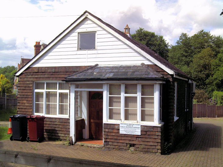
"WHATLINGTON. New Chapel,—A new and beautiful village chapel has just been erected in this parish, at the expense of Thomas Overy, Esq., a landed proprietor of the place, who has been for many years a hearty supporter of Wesleyan Methodism. It stands in a lovely situation, commanding one the most charming prospects the county of Sussex. The building, which has a spire, is most conveniently arranged; over the entrance there is gallery for the singers, and under the chapel there is commodious school-room. The opening services were held on Thursday, the 9th May, when the Rev. Luke H. Wiseman, London, preached in the afternoon and evening. Friends from all parts came in great numbers; the afternoon, those who could not crowd into the chapel adjourned to the school-room, where second service was held. In an adjoining field tea was provided in a large booth, under the superintendence of Mr A. Apps, of Woods Place, where the friends partook of an excellent tea. In the evening Mr. Wiseman preached to a large concourse of people a discourse not soon to be forgotten, the course of which the preacher spoke, in fitting terms, of the noble liberality of Mr. Overy. A collection was made afterwards providing a harmonium, and defraying incidental expenses. The services have been continued by Rev. G. Meadows and Rev. H. Brown, circuit ministers."
https://www.britishnewspaperarchive.co.uk/viewer/bl/0000257/18670525/021/0003
Sussex Advertiser - Saturday 25 May 1867
Also see:
- https://www.britishnewspaperarchive.co.uk/viewer/bl/0000438/18670521/011/0003 (Luke H. Wiseman was minister at Liverpool Road Chapel)
- https://www.britishnewspaperarchive.co.uk/viewer/bl/0000293/18820826/027/0006 (supported by Hastings Wesleyan Town and Village Mission)
- https://www.britishnewspaperarchive.co.uk/viewer/bl/0000293/18840216/026/0003 (meetings re. temperance movement)
- https://www.britishnewspaperarchive.co.uk/viewer/bl/0000293/19330729/030/0002 (new minister based at Staplecross)
- https://www.britishnewspaperarchive.co.uk/viewer/bl/0000656/19470926/084/0003 (Trustees considering disposal)
- https://www.sussexexpress.co.uk/news/people/former-chapel-in-whatlington-near-battle-to-go-under-hammer-2043235
- https://www.cliveemson.co.uk/properties/218/13/
- https://1066history.co.uk/chapels-history
Google Whatlington "White Chapel"
Northiam edit
"OPENING OF THE UNITARIAN BAPTIST CHAPEL AT NORTHIAM. — Northiam is a beautiful village in East Sussex, about twelve miles from Hastings, and the church there is supplied the Hastings Unitarian Mission, carried on by the Rev. J. A. Briggs, assisted by the Rev. P. Vancesmith, M.A., and Mr. Kennard. The chapel had become very much out of repair, and the congregation, consisting of agricultural labourers and and the working class, being unable without great assistance do the necessary repairs, considerable help has already been given or promised by friends at a distance, and the restoration now completed at a cost of about £130, which has considerably exceeded the estimated outlay owing to the building being in a worse state than was expected. The chapel as restored has an entirely new floor, the old high-backed pews replaced by open pitch pine seats, a very neat platform takes the place of the old pulpit, the walls are tastefully coloured, a very neat window has been put at the north end, and the other windows reglazed and repaired, and the old gallery removed, and raised platform for the choir (which is large and effective) has been erected. The chapel presents a neat and very comfortable appearance, and its renovated aspect the subject of general congratulation among the zealous little band of Unitarians who worship here. It appears that this congregation had its origin in 1788, Mr. Vidler (of Battle), Mr. Copping (of Sandhurst), and Mr. Purdy (of Rye), being its founders, who, at that time, were Calvinistic Baptists. In 1792 Mr. Vidler introduced the doctrine of the final restoration of all mankind in his pulpit ministrations, which led to the withdrawal of Mr. Copping and Mr. Purdy. Mr. Vidler appears to have preached here weekly till his removal from Battle to become minister at Parliament-court, London. In a subsequent visit in the year 1808, Mr. Vidler appears to have advanced to the Unitarian position, and preached the doctrine of the strict Unity of God in conjunction with Richard Wright, the missionary. This led to the withdrawal some members, but the majority appear have embraced the new faith. Afterwards Mr. Stephen Blundell, and the last settled minister, the pious John Edwards, carried the services. After his death, the chapel was closed until the Kent and Sussex Unitarian Association appointed Mr. Bayley, and afterwards Mr. Peter Dean, to carry on the services in conjunction with the church at Battle. After being closed again for some time, the Rev. J. A. Briggs, Hastings, with lay help, re-opened the chapel, and regular services have been carried on up to the present time. On Sunday, June 20 1879, the chapel was reopened by the Rev. Thos. B. W. Briggs, of Dover, who preached to attentive congregations. In the evening the chapel was full. The morning subject was on the slow but certain progress of truth, glancing at the struggles and sacrifices made by our forefathers in obtaining the measure of civil and religious liberty which is now enjoyed. In the evening the preacher dwelt on the growing seed of Christ and Christianity as corresponding with the growth of culture, the revelations of science, and the progress of civilisation. Collections were made after each service, and, considering the circumstances of the people, were liberal, a strong desire being expressed that the beautifully restored and renovated building should soon be freed from debt. Nearly £50 more is needed.— Unitarian Herald."
https://www.britishnewspaperarchive.co.uk/viewer/bl/0000293/18790712/051/0007
Hastings and St Leonards Observer - Saturday 12 July 1879
https://www.britishnewspaperarchive.co.uk/viewer/bl/0000257/18550904/045/0007 (Chapel was open in 1855)
Use this for citing district/borough boundaries edit
Use this for citing URC Cong/Pres merger edit
{{#tag:ref|The [[United Reformed Church]] denomination was formed from the amalgamation of the [[Congregational church#United Kingdom|Congregational Church]] and the [[English Presbyterianism|Presbyterian Church of England]] in 1972.<ref name="ICI226–227">{{Harvnb|Facey|1981|pp=226–227.}}</ref>|group=note}} *{{cite book|editor-last=Facey|editor-first=Roy A.|title=International Church Index (Doctrinal)|year=1981|publisher=Index Publications|isbn=0-907578-00-4|url=https://archive.org/details/internationalchu0000unse/page/n247/mode/2up|access-date=16 August 2021|url-access=registration}}
Useful book links edit
- International Church Index (Doctrinal) (published 1981)
- A Sketch of the History of Wesleyan Methodism in some of the Southern Counties of England (1885, William Willmer Pocock) (useful for Hants/Surrey/Sussex missions, circuits and chapels)
- Dictionary of Methodism in Britain and Ireland (this will be suitable to cite. Useful overview for Methodism in towns/cities, inter alia)
Something to do on Commons edit
- Add images to appropriate categories in commons:Category:Churches in the United Kingdom by name: includes Bethany, Bethel, Bethesda and all sorts of others. Also specifically for England: commons:Category:Ebenezer churches in England and commons:Category:Tabernacle churches in England.
- Also for shared churches, could use this one: commons:Category:Interdenominational Protestant churches in England
Hampshire general edit
Books in Portsmouth Library edit
- A Short History Of Eastleigh (Eastleigh and District Local History Society, 1987) Dewey Code: 942.2772(Reference LibraryOversize)
- Eastleigh and the Domesday Book (N.D. Barber, 1986) Dewey Code: 942.2772(Reference LibraryOversize)
- Eastleigh - A Railway Town (Kevin Robertson, ) Dewey Code: 942.2772()
- Estleie: From 1086-1936. The Development of Eastleigh as a Community - a Resource Pack (Nicola Gosling, ) Dewey Code: 942.2772(Reference LibraryOversize)
- Eastleigh (Gordon Cox, 1996) Dewey Code: 942.2772(Reference Library)
- Our Changing Village : Bishopstoke from 1840, Part 1 (Eastleigh and District Local History Society, 1994) Dewey Code: 942.2775(Reference LibraryOversize)
- Our Changing Village : Bishopstoke from 1840, Part 2 (Eastleigh and District Local History Society, 1994) Dewey Code: 942.2775(Reference LibraryOversize)
- Our Changing Village : Bishopstoke from 1840, Part 3 (Eastleigh and District Local History Society, 1994) Dewey Code: 942.2775(Reference LibraryOversize)
- Eastleigh, Bishopstoke and Chandlers Ford in Old Picture Postcards (G. Bowie, 1986) Dewey Code: 942.2772(Reference Library)
- Memories of Old Eastleigh and Bishopstoke (Maureen Westwood, 1985) Dewey Code: 942.2772(Reference Library)
- The Development of a Late Victorian Railway Town: Eastleigh (Bryan Luffman, ) Dewey Code: 942.2772(Reference LibraryOversize)
- Fair Oak: A Study (Paul Clark, 1989) Dewey Code: 942.2772(Reference Library)
- A Short History of Fair Oak (Gladys Purkiss, 1987) Dewey Code: 942.2772(Reference LibraryOversize)
- A History of the Parish of Fair Oak and Horton Heath: To Celebrate 100 Years of the Parish Council (Helen Douglas, 1994) Dewey Code: 942.2772(Reference Library)
- Chandler's Ford: yesterday and today (Barbara Hillier, 1998) Dewey Code: 942.2772(Reference Library)
- Chandler's Ford: a Pictorial History (Barbara Hillier, 1994) Dewey Code: 942.2735(Reference Library)
- St Boniface and St Martin in the Wood, Chandlers Ford (Margot Hegan, 1993) Dewey Code: 283.422735(Reference Library)
- St .Edward the Confessor's Church, Chandler's Ford: 1938-1988 (Chandler's Ford. St. Edward the Confessor's Church, 1988) Dewey Code: 726.5(Reference Library)
- The story of Chandler's Ford (Barbara Hillier, 1984) Dewey Code: 942.2772(Reference Library)
- Aspects of Chandler's Ford (Gordon Cox, 1983) Dewey Code: 942.2772(Reference LibraryOversize)
- Hedge End Parish: The Official Guide (Hedge End Parish Council, 1974) Dewey Code: 914.227(Reference Library)
- Changing face of Hedge End, Hampshire, Part 1 (Joyce Blyth, ) Dewey Code: 942.2775(Reference Library)
- Changing face of Hedge End, Hampshire, Part 2 (Joyce Blyth, 1981) Dewey Code: 942.2775(Reference Library)
- Hedge End and Botley in Old Picture Postcards (Milli Pharo, 1983) Dewey Code: 942.2772(Reference Library)
- One Hundred Years at St James', West End (Bob Moody, 1988) Dewey Code: 283.42276(Reference Library)
- Story Of Sarisbury and Swanwick Down Through the Ages (G. Lejeune, ) Dewey Code: 942.27(Reference Library)
- A short history of Warsash (F.W. Light, 1992) Dewey Code: 942.276(Reference Library)
- The Locks Heath story (Peter Jeffs, 1995) Dewey Code: 942.2775(Reference Library)
- History of Locks Heath (Trevor Cox, 1974) Dewey Code: 942.2775(Reference LibraryOversize)
- History of Bursledon and guide to St Leonard's Church (John Alderman, 1984) Dewey Code: 942.2772(Reference Library)
- Waterlooville: A Pictorial History (Barry Stapleton, 1996) Dewey Code: 942.2795(Reference Library)
- Waterlooville: A Modern Village (Alison Marshall, 1983) Dewey Code: 942.2795(Reference Library)
- Waterlooville and District: History and Development (A.J.C. Reger, 1963) Dewey Code: 942.27(Reference Library)
- Horndean Area Local Plan (East Hampshire District Council, 1988) Dewey Code: 711.4094228(Reference LibraryOversize)
- Leigh Park: Garden City of the South (Leigh Park Community Association, 1997) Dewey Code: 914.22795(Reference Library)
- Memories of Cowplain (Rosemary Wilson, 2014) Dewey Code: 914.22795()
- Emsworth (Linda Newell, 2006) Dewey Code: 942.2795(Reference Library)
- Emsworth: A History (Robert Whitfield, 2005) Dewey Code: 942.2795()
- A History Of Emsworth Methodist Church (G.D. Smith, 1996) Dewey Code: 287.094228(Reference Library)
- Emsworth: Echoes Of the Past (D. Rudkin, 1982) Dewey Code: 942.2795(Reference Library)
- Hayling Island (John Rowlands, 2013) Dewey Code: 942.2795(Reference Library)
- The book of Hayling Island and Langstone : more than a millennium (Peter Rogers, 2001) Dewey Code: 942.2795(Oversize)
- Hayling Island in Old Picture Postcards (Robert Godfrey, 1999) Dewey Code: 942.2795()
Diocese of Portsmouth – Past and Present (Dwyer 1981) edit
- p108: In 1944 Fr Dennis Walshe was sent to take charge of the Bitterne area. In 1960 he opened Christ the King, Bitterne. He had acquired sites in Hedge End, West End and Thornhill for future devt. HE and WE were cut off from Bitterne and formed into one parish. First parish priest, Fr Myles Christy, built St Brigid in West End; next priest, Fr David Quarmby, built Assumption at Hedge End in 1975. A Lanner hall was built in 1967 as a chapel in Thornhill. Succeeded by St Colman (separately parished). Portswood: tin tab opened in 1923 succeeded by Church of Immaculate Conception in 1955. Millbrook housing estate built in 1950s; site acquired at Redbridge Hill/Wimpson Lane junction, and a Mass Centre served from St Boniface Shirley was established in Queen Mary School Hall. 1957: separate parish formed and church hall built on the site.
- p109: Fr William Macdonald built new school and church in Millbrook. 30sq ft stained glass west window by Helen Mahoney of Dublin. Opened April 1966.
- p108: 1923: St Michael's Convent built new church. Bishop Cotter asked for it to be designed so it could be used as a parish church asd well as a convent chapel. (Waterlooville)
- p110: Mass centre started at Hythe. Served from St Joseph, Southampton, from which a curate travelled by motor boat every Sunday. Wooden church built at Holbury in 1939. 1958: site for a permanent church bought in Hythe. 1962: Hythe added to Holbury parish (prev served from Totton). 1965: built St Michael's Church in Hythe. Holbury soon became a separate parish again, and a new church was opened there.
- p122: Park Place pastoral centre, Wickham opened. First in south of England.
- p55: In 1747 Catholic descendants of Royalist adherents of James III fled north of England and settled at Soberton, where a Catholic mission was established. A farmhouse was converted into a chapel and priests house. Served by Jesuits until it closed in 1839. (This was the origin of Catholicism in the Fareham area.)
- p57: Fareham mission started in 1873 underr military chaplain and future Bishop of Gibraltar Fr James Bellord. Shed behind West Street fitted out with seats and Mass said once a week. Site for new church bought in 1874. Former timber yard between Hartlands Road and Portland Street. Building work started to the design of John Crawley. Dedicated to Sacred Heart and opened on 4/9/1878 by Bishop Danell, Bishop of Southwark.
- p22: In 1750 a chapel was buil in South Cross St, Gosport, near the present police station. Served by priest from Brockhampton (Havant), an "intrepid horseman": had to go via Portchester and Fareham as there was no ferry or railway. 1776: site of present church bought. Priest initially funded with help from a wealthy Portsmouth resident, as the mission also seved Portsea Island.
- p13: Havant: one of five ancient centres of Catholicism in Hampshire. Unbroken history throughout penal times, inc. resident priests. In 1711 John Caryll of Catherington (same family as those of West Grinstead) bought three cottages at Langstone, converted one into a presbytery and converted the three attics into a chapel. 260 Catholics noted in 1741. Chapel built at Brockhampton in 1752. By 1850s it had 2 priests and served parts of West Sussex, Portsmouth and across S Hants. New site on West Street given and new church opened 1875. Consecrated 1907.
Diocese of Portsmouth Yearbook 1987; Diocesan Information Office, Portsmouth, 1987 edit
- p41 St Paul, Paulsgrove 1970
- p45 Our Lady Queen of Apostles, Bishops Waltham: 1912, replaced 1977
- p49 St Swithun Wells Fair Oak 1978
- p50 St Philip Howard Fareham 1980
- p50 St Thomas More, Park Place, Wickham 1970
- p53 Emsworth 1959
- p53 Hayling Island 1914, replaced 1925, consecrated 28/9/1984
- p53 Hedge End 1964, replaced 1975, consecrated 23/3/1984
- p53 West End 1968
- p56 Lee on Solent 1918, replaced 1980
- p56 St Michael and All Angels, Leigh Park 1955, replaced 1970
- p58 Netley 1956
- p59 Park Gate 1965
- p66 Stubbington 1976, replaced 1985
- p68 St Joseph, Niton (served from Ventnor) 1969
- Waterlooville parish also included St Richard of Chichester, 76 London Road, Purbrook (1975; now demolished and replaced by houses) and St Augustine of Canterbury, Kite Close, Wecock Farm (1977; now Evangelical). Wecock Farm last mentioned in directories 1992; Purbrook 1995
Basingstoke and Deane edit
- Former Methodist chapel at Old Chapel Lane, Charter Alley is now Ebenezer Cottage. Deregistered 27/01/1994; present on old maps (e.g. this). 51.315912, -1.147595. The chapel shown on the same map at Ramsdell has long gone though.
City of Winchester edit
East Hampshire edit
- https://www.thegazette.co.uk/London/issue/28463/page/976 Primitive Methodist Church, Church Street, Ropley registered 03/02/1911; can't find this
- https://www.thegazette.co.uk/London/issue/27877/page/574 Wesleyan Church, Longwood Dean, Cheriton registered 18/01/1906; long since demolished
- Unsuccessful listing application for Standford Hill Methodist Church
- Giles, L.C. (1989). Liphook Calendar. Liphook: Bramshott and Liphook Preservation Society. ISBN 0-9511829-2-7.
Liphook Calendar; L.C. Giles; 1989; Bramshott and Liphook Preservation Society; Liphook; ISBN 0-9511829-2-7
- p2: RC chapel originally at Ludshott Manor. First records 1850. Burnt out in 1908 (p10: designed by Pugin) and replaced by present church in 1911
- p2: Under incumbency of W.W. Capes, Rector of Bramshott 1869-1901, Anglican mission rooms were established at Liphook, Hammer and Conford
- p8: Annexe to Liphook Church Centre dedicated 22/2/1987
- p9: Liphook originally had tin tabernacle where library car park now stands
- p10: New church centre opened by Bishop of Portsmouth 15/3/1970
- p12: New Methodist church opened 3/4/1931, replacing one on Haslemere Road (opposite Harris and Barnes)
- p14: First service at new Gospel Hall, Tower Road: 17/4/1927. P19: Founded as Liphook Brethren Assembly and first met 23/5/1926 at the Village Hall
- p20: There was a Quaker burial ground near Bramshott Court in the 17th century
- p31: First stone of Church Centre laid 14/7/1969
- p42: First Methodist chapel built 1853
- p42: Bible Christians worshipped at Passfield until 1859, when their wooden building was beyond repair. Raised funds through subscription for a new building, opened at Standford Hill in 1861. P49: Predecessor of this: room registered in a house in Passfield on 26/11/1830
- p45: Original church room completed end of 1920. Cost £500
Test Valley edit
- St Francis' Church, Knightwood Road, Valley Park on 55 A3 at 50.978963, -1.401674 (Anglican/Methodist/URC L.E.P.); note that this is just over the border in Test Valley even though it is part of Chandlers Ford!!!!
- Unsuccessful listing application for 41 Weyhill Road, Andover
- Former Methodist chapel at Sarson Lane, Amport: 51.199749, -1.562048 (deregistered in 1994; now a house; marked in North Hants street atlas @ 104 B6)
EH edit
51°08′44″N 0°58′49″W / 51.145484°N 0.980379°W 51°09′04″N 0°58′34″W / 51.151193°N 0.975978°W 51°08′44″N 0°58′39″W / 51.145622°N 0.977519°W 51°08′47″N 0°58′26″W / 51.146343°N 0.973913°W 51°08′48″N 0°58′39″W / 51.146631°N 0.977394°W 51°09′07″N 0°58′33″W / 51.152017°N 0.975887°W 51°09′07″N 0°58′09″W / 51.151884°N 0.969232°W 51°08′56″N 0°58′40″W / 51.148958°N 0.977871°W 51°08′39″N 1°00′43″W / 51.144258°N 1.011909°W 51°11′46″N 0°52′45″W / 51.196131°N 0.879262°W 51°09′29″N 1°03′00″W / 51.158001°N 1.049866°W 51°09′45″N 0°53′53″W / 51.162529°N 0.898092°W 51°05′46″N 0°53′12″W / 51.096080°N 0.886689°W 50°55′01″N 0°59′22″W / 50.917079°N 0.989537°W 50°54′49″N 0°59′40″W / 50.913473°N 0.994387°W 51°06′31″N 0°51′28″W / 51.108511°N 0.857757°W 51°06′45″N 0°51′49″W / 51.112601°N 0.863655°W 51°05′21″N 0°47′54″W / 51.089223°N 0.798205°W 50°58′29″N 0°56′50″W / 50.974788°N 0.947134°W 50°55′33″N 1°00′37″W / 50.925899°N 1.010307°W 50°56′18″N 0°57′34″W / 50.938346°N 0.959559°W 51°07′42″N 0°59′23″W / 51.128197°N 0.989768°W 50°56′48″N 1°00′31″W / 50.946643°N 1.008655°W 50°56′09″N 1°00′04″W / 50.935789°N 1.001193°W 50°56′51″N 1°00′29″W / 50.947625°N 1.007948°W 50°59′45″N 1°01′53″W / 50.995879°N 1.031487°W 51°05′08″N 1°00′00″W / 51.085573°N 1.000116°W 51°08′15″N 0°55′43″W / 51.137598°N 0.928547°W 51°04′32″N 0°55′34″W / 51.075578°N 0.926160°W 51°06′50″N 0°59′01″W / 51.113880°N 0.983697°W 51°06′20″N 1°03′02″W / 51.105619°N 1.050447°W 51°06′39″N 1°02′42″W / 51.110778°N 1.045071°W 51°01′29″N 0°59′51″W / 51.024796°N 0.997570°W 51°06′39″N 0°45′58″W / 51.110805°N 0.766015°W 51°06′40″N 0°45′19″W / 51.110997°N 0.755321°W 51°04′05″N 0°53′52″W / 51.068098°N 0.897679°W 51°07′10″N 0°56′23″W / 51.119436°N 0.939816°W 51°03′25″N 0°56′13″W / 51.056971°N 0.937076°W 51°07′12″N 0°49′38″W / 51.119903°N 0.827313°W 51°07′20″N 0°48′18″W / 51.122176°N 0.804969°W 51°02′03″N 0°59′12″W / 51.034200°N 0.986561°W 51°01′56″N 0°52′33″W / 51.032291°N 0.875813°W 51°02′05″N 0°52′40″W / 51.034848°N 0.877795°W 51°09′57″N 0°57′14″W / 51.165789°N 0.953758°W 51°09′40″N 0°57′14″W / 51.161185°N 0.953764°W 50°54′44″N 1°00′06″W / 50.912136°N 1.001799°W 50°55′11″N 0°59′56″W / 50.919859°N 0.998806°W 50°54′24″N 0°59′33″W / 50.906740°N 0.992522°W 50°54′41″N 1°00′13″W / 50.911404°N 1.003691°W 50°55′17″N 0°56′41″W / 50.921304°N 0.944637°W 51°08′17″N 0°52′27″W / 51.137969°N 0.874130°W 51°00′34″N 0°59′55″W / 51.009575°N 0.998613°W 51°10′41″N 1°02′03″W / 51.177921°N 1.034249°W 51°07′17″N 0°50′47″W / 51.121279°N 0.846306°W 51°04′28″N 0°48′16″W / 51.074353°N 0.804340°W 51°04′43″N 0°48′04″W / 51.078550°N 0.800987°W 51°04′51″N 0°48′15″W / 51.080798°N 0.804299°W 51°05′03″N 0°48′18″W / 51.084030°N 0.805043°W 51°02′52″N 0°51′25″W / 51.047703°N 0.856958°W 51°02′59″N 0°53′02″W / 51.049735°N 0.883891°W 50°54′40″N 1°01′38″W / 50.911233°N 1.027262°W 51°07′48″N 1°03′57″W / 51.130009°N 1.065753°W 51°07′08″N 1°03′36″W / 51.119015°N 1.060036°W 51°05′25″N 0°58′01″W / 51.090307°N 0.967024°W 51°07′14″N 0°54′03″W / 51.120431°N 0.900707°W 51°00′12″N 0°56′15″W / 51.003220°N 0.937580°W 51°00′24″N 0°56′21″W / 51.006540°N 0.939258°W 51°00′25″N 0°56′22″W / 51.007003°N 0.939430°W 51°00′16″N 0°56′22″W / 51.004385°N 0.939391°W 51°00′25″N 0°56′00″W / 51.006910°N 0.933440°W 51°03′40″N 0°57′46″W / 51.061142°N 0.962760°W 51°05′00″N 1°04′45″W / 51.083401°N 1.079228°W 50°53′06″N 0°58′11″W / 50.885087°N 0.969643°W 50°53′26″N 0°57′44″W / 50.890436°N 0.962293°W 51°10′53″N 0°49′39″W / 51.181295°N 0.827462°W 51°05′55″N 0°56′35″W / 51.098520°N 0.942917°W 51°10′13″N 1°00′37″W / 51.170296°N 1.010143°W 51°00′57″N 0°55′15″W / 51.015748°N 0.920837°W 51°06′11″N 0°50′17″W / 51.103127°N 0.837972°W 51°01′20″N 0°56′16″W / 51.022245°N 0.937894°W 51°00′44″N 0°57′55″W / 51.012353°N 0.965379°W 51°10′48″N 0°55′13″W / 51.180116°N 0.920328°W 51°08′41″N 1°06′11″W / 51.144615°N 1.103010°W 51°02′43″N 0°53′45″W / 51.045204°N 0.895892°W 51°03′08″N 0°54′08″W / 51.052328°N 0.902087°W 51°03′31″N 1°04′25″W / 51.058572°N 1.073615°W 51°07′39″N 0°56′32″W / 51.127490°N 0.942237°W 50°58′33″N 0°56′59″W / 50.975743°N 0.949668°W 51°04′19″N 0°59′37″W / 51.071837°N 0.993698°W 50°59′39″N 1°01′57″W / 50.994115°N 1.032531°W 51°00′41″N 1°03′54″W / 51.011386°N 1.064945°W 50°59′39″N 1°01′52″W / 50.994137°N 1.031020°W 50°54′37″N 0°57′06″W / 50.910176°N 0.951746°W 51°04′01″N 0°53′49″W / 51.066941°N 0.897083°W 50°54′40″N 1°00′10″W / 50.911036°N 1.002659°W 51°08′05″N 0°53′19″W / 51.134681°N 0.888610°W 51°02′35″N 0°53′25″W / 51.043127°N 0.890176°W 50°54′37″N 1°01′31″W / 50.910208°N 1.025164°W 51°04′26″N 1°02′51″W / 51.073817°N 1.047633°W 51°07′20″N 0°54′02″W / 51.122327°N 0.900500°W 51°00′28″N 0°55′50″W / 51.007788°N 0.930626°W 51°00′11″N 0°56′10″W / 51.003065°N 0.936020°W 51°00′24″N 0°56′15″W / 51.006717°N 0.937545°W 51°00′20″N 0°56′10″W / 51.005624°N 0.936043°W 51°02′17″N 1°02′10″W / 51.038096°N 1.036201°W 50°59′44″N 0°59′46″W / 50.995685°N 0.996232°W 51°05′42″N 0°56′20″W / 51.095080°N 0.939024°W 51°05′47″N 0°56′26″W / 51.096461°N 0.940627°W 51°06′06″N 0°50′14″W / 51.101644°N 0.837118°W 51°00′31″N 0°57′55″W / 51.008732°N 0.965226°W 51°08′40″N 1°06′09″W / 51.144426°N 1.102511°W 51°02′45″N 0°53′45″W / 51.045907°N 0.895744°W 51°08′38″N 0°59′02″W / 51.144018°N 0.983772°W 51°08′39″N 0°59′01″W / 51.144274°N 0.983696°W 51°09′05″N 0°58′17″W / 51.151278°N 0.971392°W 51°08′06″N 0°52′28″W / 51.134935°N 0.874553°W 51°09′50″N 0°56′53″W / 51.163813°N 0.948049°W 51°09′44″N 0°49′50″W / 51.162146°N 0.830681°W
Win edit
51°05′25″N 1°09′40″W / 51.090143°N 1.161022°W 51°05′13″N 1°10′40″W / 51.087043°N 1.177909°W 51°05′19″N 1°09′50″W / 51.088591°N 1.163979°W 51°05′14″N 1°09′51″W / 51.087311°N 1.164134°W 51°05′14″N 1°14′26″W / 51.087118°N 1.240520°W 51°01′53″N 1°10′45″W / 51.031261°N 1.179290°W 51°06′23″N 1°07′47″W / 51.106427°N 1.129837°W 51°05′03″N 1°08′10″W / 51.084255°N 1.136138°W 50°57′21″N 1°12′37″W / 50.955842°N 1.210337°W 50°57′15″N 1°12′47″W / 50.954157°N 1.213014°W 50°57′14″N 1°12′41″W / 50.953808°N 1.211512°W 50°57′15″N 1°12′42″W / 50.954165°N 1.211631°W 50°57′13″N 1°13′17″W / 50.953515°N 1.221471°W 50°52′15″N 1°08′38″W / 50.870885°N 1.143824°W 51°02′47″N 1°07′53″W / 51.046455°N 1.131452°W 51°03′32″N 1°05′59″W / 51.058926°N 1.099818°W 51°03′10″N 1°10′16″W / 51.052758°N 1.171116°W 51°02′54″N 1°16′40″W / 51.048392°N 1.277826°W 50°59′29″N 1°18′30″W / 50.991348°N 1.308389°W 50°59′50″N 1°19′09″W / 50.997338°N 1.319048°W 51°01′42″N 1°20′03″W / 51.028283°N 1.334077°W 50°58′45″N 1°07′57″W / 50.979077°N 1.132421°W 51°06′41″N 1°23′44″W / 51.111367°N 1.395477°W 51°06′39″N 1°23′22″W / 51.110861°N 1.389388°W 50°55′19″N 1°15′00″W / 50.921965°N 1.249915°W 50°54′16″N 1°03′54″W / 50.904545°N 1.064958°W 50°54′00″N 1°04′38″W / 50.899989°N 1.077327°W 50°57′36″N 1°08′10″W / 50.960092°N 1.136006°W 50°57′00″N 1°16′55″W / 50.950039°N 1.281909°W 51°09′27″N 1°13′39″W / 51.157409°N 1.227500°W 51°05′15″N 1°16′28″W / 51.087368°N 1.274494°W 50°59′09″N 1°07′39″W / 50.985742°N 1.127453°W 51°02′42″N 1°26′04″W / 51.044978°N 1.434557°W 50°55′57″N 1°04′54″W / 50.932552°N 1.081639°W 50°55′51″N 1°05′12″W / 50.930852°N 1.086801°W 51°05′07″N 1°18′20″W / 51.085167°N 1.305484°W 51°02′39″N 1°08′58″W / 51.044185°N 1.149480°W 51°09′14″N 1°18′48″W / 51.153992°N 1.313435°W 51°01′31″N 1°23′29″W / 51.025333°N 1.391347°W 51°05′29″N 1°14′17″W / 51.091405°N 1.238121°W 51°02′01″N 1°09′29″W / 51.033477°N 1.158014°W 51°05′18″N 1°17′51″W / 51.088256°N 1.297633°W 51°07′26″N 1°15′53″W / 51.123992°N 1.264611°W 51°05′37″N 1°21′13″W / 51.093619°N 1.353732°W 51°05′31″N 1°15′54″W / 51.091992°N 1.265044°W 50°58′41″N 1°07′49″W / 50.978108°N 1.130210°W 51°08′57″N 1°16′06″W / 51.149073°N 1.268381°W 51°01′35″N 1°16′28″W / 51.026486°N 1.274567°W 50°54′37″N 1°07′55″W / 50.910233°N 1.132026°W 51°07′58″N 1°11′41″W / 51.132710°N 1.194792°W 51°05′57″N 1°09′41″W / 51.099202°N 1.161434°W 51°02′53″N 1°20′49″W / 51.047934°N 1.346899°W 51°03′09″N 1°20′50″W / 51.052475°N 1.347166°W 51°00′11″N 1°21′02″W / 51.003056°N 1.350439°W 51°04′52″N 1°12′02″W / 51.081008°N 1.200593°W 51°00′28″N 1°16′03″W / 51.007646°N 1.267494°W 50°54′59″N 1°12′09″W / 50.916444°N 1.202421°W 50°55′21″N 1°11′21″W / 50.922440°N 1.189217°W 50°56′51″N 1°08′01″W / 50.947404°N 1.133586°W 50°55′42″N 1°08′16″W / 50.928419°N 1.137872°W 51°07′11″N 1°19′52″W / 51.119650°N 1.331141°W 51°07′30″N 1°19′36″W / 51.124997°N 1.326794°W 50°52′26″N 1°06′42″W / 50.873899°N 1.111729°W 51°04′43″N 1°22′48″W / 51.078567°N 1.380053°W 51°03′14″N 1°20′03″W / 51.054021°N 1.334149°W 51°03′09″N 1°19′59″W / 51.052378°N 1.332964°W 51°09′02″N 1°18′09″W / 51.150623°N 1.302546°W 50°56′39″N 1°10′52″W / 50.944221°N 1.181027°W 50°56′32″N 1°10′46″W / 50.942179°N 1.179570°W 51°04′08″N 1°11′23″W / 51.068853°N 1.189712°W 51°04′12″N 1°10′59″W / 51.069967°N 1.183090°W 51°01′23″N 1°18′54″W / 51.022936°N 1.315041°W 51°01′01″N 1°19′09″W / 51.016835°N 1.319272°W 50°58′57″N 1°14′02″W / 50.982416°N 1.234023°W 50°56′08″N 1°12′14″W / 50.935580°N 1.203811°W 51°00′00″N 1°06′51″W / 50.999993°N 1.114248°W 51°04′35″N 1°20′12″W / 51.076434°N 1.336549°W 51°04′18″N 1°20′01″W / 51.071725°N 1.333599°W 51°04′29″N 1°20′09″W / 51.074665°N 1.335821°W 51°00′46″N 1°05′22″W / 51.012904°N 1.089320°W 50°53′59″N 1°11′00″W / 50.899629°N 1.183261°W 50°52′35″N 1°13′04″W / 50.876324°N 1.217721°W 50°54′03″N 1°11′49″W / 50.900872°N 1.197047°W 51°03′30″N 1°18′13″W / 51.058232°N 1.303596°W 51°03′37″N 1°19′19″W / 51.060304°N 1.321997°W 51°03′53″N 1°18′41″W / 51.064813°N 1.311251°W 51°02′49″N 1°19′19″W / 51.047080°N 1.322023°W 51°04′08″N 1°18′51″W / 51.068942°N 1.314299°W 51°03′44″N 1°18′23″W / 51.062302°N 1.306364°W 51°03′41″N 1°18′33″W / 51.061495°N 1.309240°W 51°03′45″N 1°18′53″W / 51.062509°N 1.314857°W 51°04′00″N 1°19′16″W / 51.066717°N 1.321180°W 51°03′33″N 1°18′52″W / 51.059175°N 1.314426°W 51°03′39″N 1°18′47″W / 51.060715°N 1.313134°W 51°03′59″N 1°18′58″W / 51.066283°N 1.316081°W 51°03′55″N 1°19′03″W / 51.065343°N 1.317596°W 51°03′49″N 1°18′42″W / 51.063614°N 1.311759°W 51°03′25″N 1°18′20″W / 51.057015°N 1.305690°W 51°03′54″N 1°18′10″W / 51.064925°N 1.302709°W 51°03′26″N 1°19′21″W / 51.057209°N 1.322366°W 51°03′50″N 1°18′59″W / 51.064003°N 1.316369°W 51°03′42″N 1°18′40″W / 51.061617°N 1.311239°W 51°04′30″N 1°19′19″W / 51.074975°N 1.321995°W 51°03′36″N 1°18′34″W / 51.059938°N 1.309421°W 51°04′03″N 1°18′56″W / 51.067485°N 1.315452°W 51°03′54″N 1°18′54″W / 51.064891°N 1.314921°W 51°03′54″N 1°18′47″W / 51.065098°N 1.313063°W 51°03′10″N 1°18′24″W / 51.052814°N 1.306766°W 51°09′11″N 1°19′10″W / 51.153145°N 1.319365°W 51°10′46″N 1°11′49″W / 51.179541°N 1.196961°W 51°05′25″N 1°09′55″W / 51.090178°N 1.165348°W 51°05′25″N 1°09′53″W / 51.090149°N 1.164735°W 51°00′24″N 1°15′00″W / 51.006707°N 1.250003°W 51°03′14″N 1°10′08″W / 51.053825°N 1.168841°W 50°54′05″N 1°15′06″W / 50.901337°N 1.251539°W 50°55′25″N 1°14′44″W / 50.923479°N 1.245435°W 50°53′54″N 1°03′39″W / 50.898422°N 1.060784°W 50°57′38″N 1°08′22″W / 50.960429°N 1.139419°W 50°57′11″N 1°15′25″W / 50.953193°N 1.256845°W 51°05′09″N 1°16′11″W / 51.085780°N 1.269663°W 51°05′18″N 1°12′11″W / 51.088417°N 1.203083°W 51°04′55″N 1°22′11″W / 51.081981°N 1.369760°W 51°09′09″N 1°16′21″W / 51.152390°N 1.272393°W 51°10′43″N 1°15′38″W / 51.178532°N 1.260514°W 50°53′33″N 1°08′37″W / 50.892578°N 1.143542°W 51°03′00″N 1°21′29″W / 51.050015°N 1.358001°W 51°01′20″N 1°19′38″W / 51.022142°N 1.327203°W 50°55′01″N 1°12′11″W / 50.916818°N 1.203156°W 51°04′39″N 1°22′49″W / 51.077459°N 1.380261°W 51°09′11″N 1°20′24″W / 51.153170°N 1.340046°W 51°00′15″N 1°06′44″W / 51.004219°N 1.112226°W 51°00′44″N 1°05′13″W / 51.012128°N 1.086977°W 51°02′22″N 1°04′48″W / 51.039582°N 1.080029°W 50°53′54″N 1°11′17″W / 50.898215°N 1.187956°W 51°03′43″N 1°18′45″W / 51.061917°N 1.312635°W 51°03′28″N 1°18′58″W / 51.057667°N 1.316121°W 51°03′36″N 1°18′25″W / 51.060128°N 1.306955°W 51°03′52″N 1°18′52″W / 51.064359°N 1.314424°W 51°03′51″N 1°18′48″W / 51.064160°N 1.313236°W 51°03′49″N 1°18′50″W / 51.063667°N 1.314014°W 51°04′14″N 1°19′13″W / 51.070560°N 1.320174°W 51°04′04″N 1°19′14″W / 51.067795°N 1.320590°W
To investigate for Sussex places of worship lists... edit
Based on notes at the various talk pages. Tick off or note findings in that column when the article is updated.
| List | Details | Notes | URLs | Findings |
|---|---|---|---|---|
| Horsham | Anglican Mission Hall, Five Oaks | On Stane Street, 50.9983N, 0.4699 W. Wilcox says building erected 1892. Looks like this has been demolished. | Looks like it has indeed been demolished. One for this list? | |
| Horsham | Methodist Mission Hall, Adversane | On Adversane Lane, 51.0453N, 0.4346W (Methodist). Wilcox cites records for 1852–1968, though it's not on the c.1900 OS maps. It's now owned by a trust which leases it to the local council. | There is a building there. Needs a visit to investigate. | |
| Horsham | Kings House, Southwater | This new place of worship has been registered for marriages] (23/1/2017). | [1] [2] | Google Southwater "Kings House". |
| Chichester (C) | Grace Church Chichester | Marriage registration cancelled | [3] | Now a multi-centre church (Chi, Bognor, Midhurst) and all meet in college/university/school buildings. Move to Chichester (F). |
| Chichester (F) | Former mission hall at Colworth near Oving | On maps from 1910 to 1952 (50.820758, -0.712992) | [4] | ... |
| East Sussex (D) | St Aidan's, Eastbourne | According to Wilcox (2004, p. 136) St Aiden's Methodist Church was in Longstone Road before Whitley Road, and he dates it to 1897 (he dates Whitley Road to 1911). The 1898 25" OS map shows a "Meth. Chap." on Longstone Road at 50.7715 0.2892. The houses now on the site are self-evidently more recent than the rest of the terrace. | ... | |
| East Sussex (D) | A lost Newhaven Baptist Church | The description of the current Newhaven Baptist Church at List_of_places_of_worship_in_Lewes_District mentions a previous church founded in 1835. The OS maps show that it clearly wasn't on the same site, but Wilcox (p.30) lists a Baptist church at "South Street" founded in 1835, later a Boys' Club. The 1890 OS maps show a chapel on the east side of South Road at the position now occupied by No. 14 South Road). The 1955 OS map labels this building "Shakespeare Hall (Boys' Club)". This is clearly the building referred to by Wilcox, and it does seem very likely that this is the earlier chapel of the current Newhaven Baptist Church. | ... | |
| East Sussex (D) | A lost Newhaven Baptist Church | I've just realised that the building at 14 South Road is listed at List_of_places_of_worship_in_Lewes_District with the closed churches for Newhaven as former Primitive Methodist Chapel from 1885. However there's no sign of another chapel on South Road in the OS maps. Things aren't helped by the fact that Newhaven Historic Character Assessment cites: "a Baptist chapel (Chapel Street, 1875), a Primitive Methodist chapel (South Road, 1885), a Wesleyan Methodist chapel (Chapel Street, 1893)," and there is, again, only one chapel on Chapel Street. Somehow we're a Baptist chapel short on one of these streets and one of the sources is mistaken about where it was. | ... | |
| East Sussex (D) | Jarvis Brook | The 1908 OS map shows a "Cong. Church" on Windsor Rd. in Jarvis Brook at exactly the co-ordinates of the current Kingdom Hall (51.0484°N 0.1864°E). It's not there on the 1897 map, but a church is still marked on the 1954-57 1" map (though it's not labelled, so might not still be Congregational). Still, this is 30 years before the foundation of the Kingdom Hall. Wilcox only lists one Cong. Church in Jarvis Brook - clearly the one already listed in this article at Tubwell Lane. The Windsor Road one (clearly identified as being next to the Memorial Hall) is mentioned at the URL. | [5] | ... |
| East Sussex (D) | St Martin, South Heighton | This church was located at 50.8064N 0.0578W. The 1898 OS map already says "remains of", the 1956 map simply says "site of". Wilcox says it "burnt down in 18th cent, replaced by an iron building in 1894". | ... | |
| West Sussex (D) | St Mary, Duncton | I've added St Mary, Duncton, the location of which is shown on the old OS maps. I haven't any source to hand for the completed date, so I've just put before the start date of the parish register as a place-holder. I'm not sure the site is actually vacant - from the aerial photos it looks like it might have been incorporated in the nearby farm. Local knowledge needed! | ... | |
| West Sussex (D) | A demolished mission hall in Pease Pottage | There was another mission hall in Pease Pottage in addition to the one listed as closed at List_of_places_of_worship_in_Mid_Sussex#Closed_or_disused_places_of_worship. Two mission halls are listed for Pease Pottage in the gazetteer of the Crawley Encyclopedia, the one already listed on this page and another. It's clearly shown on the 1:2500 OS map for the 1950s at 51.0813°N 0.2030°W as "Mission Church (C of E)". The London Gazette for 18th Aug. 1970 gives "Mission Hall, Pease Pottage" as a business address, and the modern aerial photos and Google Streetview show a quite different building on the site now. | [6] [7] | ... |
| West Sussex (D) | St Martin in the Vintry, Chichester | Wilcox says this was demolished in 1903. It stood in St Martin's Street (50.8374N 0.7775 W) and it looks like the walls have been partly preserved and the rest turned into a garden. | [8] | ... |
| West Sussex (D) | St Peter the Less, Chichester | North St (50.8386 N 0.7785 W). Sussex Parish Churches say demolished 1960, Wilcox says 1957. | [9] | ... |
| West Sussex (D) | Kingston Gorse | The parish church of Kingston Gorse was swallowed by the sea in about 1630. Perhaps it deserves an entry (though an accurate gridref will be a problem). (Talk page ref for this one is at Talk:List of demolished places of worship in Brighton and Hove) | ... |
Isle of Wight edit
- Kelly (1907) mentions RC missions/churches at Appuldurcombe (iron chapel), Carisbrooke (St Dominic's Priory - chapel open to public), Cowes, Freshwater (Weston Manor chapel), Newport, Ryde, Shanklin and Ventnor
- Hague (1986) mentions Newport Unitarian on pp50, 52, 62
- The Assemblies Address Book (2002) mentions Clarence Road Evangelical Church, Bethany Evangelical Church and Shanklin Gospel Hall.
- Ref for Newport JWKH (ex-Brethren meeting room):[3]
- Brethren m/rooms mentioned on the 1963 list:
- 50.676860, -1.528715 might be the one @ Middleton, Freshwater
- Medina Avenue, Newport has gone (was at 50.695910, -1.291359; marked as Mission Hall on 1906 and 1938 map, but not on 1896). Streetview shows demolition underway in Sep 2011: planning app TCP/18290/B (Jan 2008) (Design and Access Statement)
- Percy Avenue: obviously the Lake Green Christian Mission
- Catholic churches:
- Bembridge
- Cowes (interesting DYK hook potential re. tornado!)
- East Cowes
- Newport
- Ryde
- Sandown
- Seaview
- Shanklin
- Totland Bay
- Ventnor
Former churches on Heritage at Risk Register:
- Old Church of St Boniface in Bonchurch (structural problems and decaying stonework)
- The former Holy Trinity Church in Ryde (decaying stonework and timberwork and water ingress)
"At Risk" register edit
Story about Sussex places of worship coming on/going off Historic England's "At Risk" register
Directory of C20 churches edit
Quaker Meeting Houses (Butler 1999) notes edit
- Farnham FMH
Old meeting house 1668-1712 no trace. In 1945 bought 1899-built semi for £1925. Altered to provide GF meeting house and Ff flat. Improved 1965 and 1991. In Guildford & Godalming MM (Monthly Meeting). P589
- Godalming FMH
- 1668-1841: Guildford MM
- 1841-1868 and 1926-1961: Dorking, Horsham and Guildford MM
- 1961-: Guilt & Godalming MM
- Meeting founded c1687. Caleb woods bought Mill House asa meeting g place. £15 from 9 subscribers. Receipt dated 26/3/1701. Bought adjoining house in 1702 and left to son in will in 1711. P589
- He sold it to Friends in 1715 for £30 (they had been using it but not owned it to that point). No trace remains: current FMH is 1748 with narrow detached wing c1772 (extended 1808 as women's m room). Cause died out in 1868, then let to Brethren for 1s per year. Acquired in 1926 for£200 by Friends from estate of Francis Ashby (a Quaker) who had bought it in 1923. Repirs in 1938; lobby later built to connect the rooms (the 1772 room was now a classroom). Classroom became kitchen. £26K of improvement s in 1991. Burials in garden from 1709, superseding Binscomb burial ground used from 1666 and with 188 Quaker burials. Plaque there in 1988. P590
- Guildford FMH
- Same arrangements and years as Godalming except continuously in DH&G
- Monthly meetings of 400-500 in Guildford in 1669. Burial ground created 1673 and adjacent tenement Vought and registered in 1689 (cost £234). A tenant still lived there until 1695. P590
- Burial ground extended 1739 for £100. Meeting house decayed by 1802 and decided to rebuild. Old one demolished, but burial ground remauned with Quaker until 1927 when given to council as public open space. Plot opposite (on N St) bought for £105 in 1803. Extra entrance built in 1827. New mh opened 1806 with separate room for women and full wooden furnishings. Quaker architect John Bevan involved. Altered 1898 and 1813 when porch added, also heating and a second storey over the women's room. £23,500 repairs in 1993. P591
- Woking (from 1947 same details as Godalming)
- From 1947 at YMCA hall. Meeting house proposed 1958. In 1965 they paid £8000 for a house and altered for £2k to give 60-capacity meeting room, classroom and flat. Opened 1966. P596
- Bexhill p599
- First meetings 1957. In 1965 they bought Brethren meeting room (1959) for £8k and minimally altered. Opened 1966
- Bognor p599
- £105k paid for house in 1993. Minimal alteration and opened that year with "substantial open plan meeting room"
- Ditchling p603
- Unitarian chapel used from 1949 or earlier. 1860s slaughterhouse bought for £5000 and altered by architect Ronald H Carn in 1966
- Eastbourne p603
- Bought house and garden and stables in 1938. stables had become garages; they converted into meeting house. Opened 1939, bombed 1943.rebuilt with new layout and incorporating old house in 1952 for £8,210 by H Hubbard Ford.
Blatch (1997) edit
"Shift of population further from London led to more churches needed in outer commuter areas. usually sums available were modest e.g. GS Pyrford £4,500 1961-64 David Bye. others churches of this type built in 1960s of laminated wood. Bright, cheerful and we'll suited to modern needs. Burpham, Wood St" p55, The Churches of Surrey, Mervyn Blatch, Phillimore, 1997, 1-86077-002-9
- p60: Addlestone (James Savage, 1836–38. Parished 1857. Rebuilt 1883 and 1903–04.)
- p77: Byfleet
- pp86–87: Chertsey
- pp91–92: Chobham
- pp92–93: Cobham
- pp105–106: East Molesey St Mary
- p106: East Molesey St Paul (Salter and Laforest 1854. Tower 1888. Kempe windows 1891 and 1899.)
- pp1019–110: Englefield Green (Edward Buckton Lamb. F stone 28/10/1859. Dedicated 5/7/1859.)
- pp110–112: Esher St George
- p112: Esher Christ Church
- p121: Frimley St Peter (1825. Commissioners' Church by J.T. Parkinson. Enlarged 1881.)
- pp134–135: Hersham (Originally chapel of ease to Walton St Peter. Original church 1839; dem and replaced 1889.)
- p150: Longcross (1847 by Willoughby. Extended 1878. "Appealing country atmosphere".)
- pp150–151: Long Ditton
- pp151–152: Lyne (Holy Trinity. Built 1848–49 by F. Francis to serve the area between Chertsey and Addlestone. Cruciform.)
- pp175–177: Pyrford
- pp188–191: Stoke d'Abernon
- pp195–196: Thames Ditton
- pp196–197: Thorpe
- pp202–204: Walton-on-Thames
- p207: West Byfleet (1-acre site bought in 1900 and Caroe appointed architect in 1901. Financial and other delays; f stone laid 15/6/1910 and church consecrated 11/10/1913. Prominent site.)
- p210: West Molesey
- pp210–211: Weston Green ("A foretaste of [Guildford Cathedral]" with its spacious interior and tall, narrow windows.)
- pp211–212: Weybridge
- pp213–215: Windlesham
- pp217–219: Old Woking
- pp219–220: Woking Christ Church
- p220: Woking St Paul (consecrated 28/11/1895; built by Rev William Hamilton, who also paid for St Mary of Bethany.)
- p220: Knaphill (red brick in Romanesque style by J.H. Ball.)
- p224: Woodham
Around Haslemere and Hindhead in Old Photos edit
(Tim Winter and Graham Collyer, Alan Sutton Publishing, Stroud, 1991, 0-86299-937-5)
- p23: St Bartholomew Church: Chapel of ease to Chiddingfold; dem and rebuilt Jul 1870–Jul 1871. Local architect John Wornham Penfold involved
- p35: Strict Baptist Chapel built 1862. F stone 12 May William Wield. Disused skittle alley since 1846 had been used. Nearby stream used until baptistery built 1866.
- p56: Highcombe Edge built 1897 by Rayner Storr. 44 acres. Later owned by Viscount Exmouth, then Lloyd's Bank.
- p59: URC at Tower Rd built as Cong Hall in 1896. First service 9 Aug. Hindhead Free Church from 1900 when John Grover added manse and school. (NB. he built New Scot Yd)
- p69: St Albans consecrated 1907 and parished 1908. First proposed in 1899. Land from Lord Ashcombe. Tin tab used from 1905.
- p93: Bowlhead Green. No chapel since minister Isaac Kettle died in 1906. Roving preacher for many years in Devils Punchbowl area. Chapel bequeathed to relative and became cottage.
- p125: Shottermill church 1846, parished 1847, extended 1876/1892, restored 1897/1910. Had been in Frensham parish. War memorial in front.
- p126: Holy Cross Hospital founded 1917 by Congregation of Daughters of the Cross. TB sanatorium originally.
- p137: St Christopher's built for £5K and consecrated 1903. Tin tab on Kings Rd used until then.
- p156: All Saints designed by Swede Axel Haig of Ewan Christian's office for £4,750 mostly paid for by Alfred Harman of Grayswood Place. Haig died 1921 and grave is marked by sailing ship.
The Baptist Churches of Surrey edit
(Ed. Arthur H. Stockwell, 1909, Stockwells, London)
- Addlestone pp5–11
Formed 9/7/1828, but cottage meetings from 1790. Site for new chapel bought c1839. Some Strict Baptists seceded at this point. £500. New chapel built for £1300 in 1872; Spurgeon laid foundation stone. Mission churches founded at Woking (separate in 1884) and Anthony's. P9
- Banstead pp14-15
250-capacity church on High St formed March 1907. Only Free Church to serve Woodnansterne, Chipstead and Banstead at that point.
- Cranleigh pp62–65
- Dorking pp83–86
- Dormansland pp87–90
- E Molesey p90
Founded 1885 with 250-capacity tin tabernacle.
- Esher pp100–101
Fellowship dates from 1852. Shared Friends Meeting House until chapel and schoolroom built on Park Rd. Branch chapel in Oxshott 1873.
- Godalming p102
First meetings in a hall in conjunction with Pioneer Mission and Guildford Baptist Church. Stone-fronted chapel built in late C19 in Queen Street. Capacity 200.
- Godstone p103
Founded in tin tabernacle 15/2/1882. 250 capacity. Schoolroom as well.
- Horley pp115–116
Founded 1881 in "excellent set of buildings" with 320-capacity chapel, vestries, schoolroom and house. Paid for by Samuel Barrow JP of Dunsfold, who also funded Godstone chapel inter alia.
- Anthony's, pp117–118
E.W. Tarbox, pastor of Woking Baptist Chapel, started a cottage meeting. 60-capacity mission hall built in garden of house in 1887. Tarbox bought site for new chapel in 1900 and built the "pretty and convenient brick chapel" for 120 people. Charles Spurgeon opened it in 5/1901.
- Pirbright pp177–180
Providence Mission Chapel only nonconformist church in the village. Work started in early C19 , and after a blacksmith's shop was used a 120-capacity chapel was built in 1868 by B. Smith who then passed it to the Surrey Mission.
- Outwood, p187
T. Green, pastor at Turners Hill chapel, moved to Outwood for work in 1864 (was teacher, became shopkeeper and farmer). He became pastor at the Outwood Chapel for the next 40 years. Became part of Home Counties Baptist Mission and had membership of 22 in 1909 and 30 children at the school.
- Woking pp248-250
Monumental Inscriptions at Meadrow Chapel, Farncombe (transcript - SHC 07035596) edit
- Burials ceased in 1869. First transcript made in 1879.
- Four vaults in yard right in front of chapel: from N to S...
- Henry Portsmouth Elphs (1833) and Betty Elphs (1834)
- Thomas (1810) and Ann (1816) Piseley
- John (1824), Mary (1825) and daughter Sarah (1815) Ellis (John Ellis was a main contributor to construction of building)
- George (1843) and Emily (1848) Knight
- In front of left side of chapel, three rows of 8, 2 and 9 graves. 4 on path, then 2 rows of 5 and 4 on right of path.closed to the road, 4 on N wall (behind 1870 building) and 6 on S wall. 46 burials inx the vaults. Pilsley (1810) was the first burial.
7 of the first 8 are Cooke. Ellis appears 12 times.
Godalming Meeting House Burial Ground edit
Typewritten manuscript at SHC. Records from 1709 (Jane Chandler of Bramley) to 1890 (Mary Dudley - "this is the last interment allowed". Frequent names include Boxall, Constable, Dawes, Kidd, Peto, Sweetapple, Trimmer and Waring. Most local but ones from Worcester, Deal and London.
289.6 stock number 09502955
The Catholic Parish of St Edmund's, Godalming, 1899–1999 edit
Bernard Polack and John Whitbourn, Arrow Press, Farnham, 1999. no ISBN
P2 Sutton Park was the rendezvous for all Surrey Catholics during the post-Ref period P3 At time of Spanish Armada, one recusant at Godalming andanther at Yhursley, but Sir William More found none in 1591. P3&4 By mid 17c, Godalming a hotbed of radical Protestant nonconformity. P4" & 5 Nevertheless, no great protest when overtly Catholic Oglethorpe family moved to Westbrook in 1688. Theophilus (father of James, founder of Georgia) was CoE but wife and daughters RC and Mass was probably said at Westbrook house. T was later the local MP.
P6 RC chapel (vanished) existed I. Guildford by 1801 - possibly house staffed by French émigré priests. Guildford RC mission not established until 1857. It was the 4th in Surrey. By now about 60 RCs in Godalming: they travelled to Guildford for Mass. 1899: tin tabernacle erected in Godalming and served by Franciscan friars from Chilworth and priests from Guildford. On site of present St Edmund's Hall. Present Bargae Stone cur g uilt 1904.
P7 Parish is 100 sq ml and is bounded by Guildford, Bramley & Cranleigh (Bramle was part of Godalming until 1955), Haslemere (separated in 1924) and Farnham. has priest and deCon; no longer served by two priests. Mass is saidat Godalming (the parish church), Milford (daughter church), CoE church at Farncombe, monthly for retired parishioners at Ladywell Convent, and monthly at the HydonHill Cheshire Home. Parish also seves ST Edmund's primary School and the convent and Milford Hospital. Average Mass attendance: 1910 138, mid-1960s 900, 1999 426.
P8 Captain WH Rushbrooke (later a papal count an a JP) , a benefactor of St J Guildford, biygt land in Croft Rd for tin tabernacle. Opened by Bishop Bourne on 26/11/1899. Rushbrooke suggested the dedication: he was from Suffolk, where the sain died and was buried. Resident priest appointed 1904. Parish initially covered from Hindhead to Cranleigh. Rushbrooke built private chapelat his house, Cosford House in Bowlhead Green, also helped found Farnhm mission. Mission chapel was founded at Haslemere in 1908.
P9 St Edmund's Hall built 1925 on tin tabernacle sure diagonally opposite current church. Demolished in 1997 for flats. First priest (1904) was St George Kieran-Hyland who was 29.previously curate at Southwark Cathedral. He determined to build a permanent church on the "toweing bank of undeveloped hillside" opposite. Land acquired 15/5/1905. Foundation stone 8/10/1905. Completed 27/6/1906. Antonymous benefactor paidsome of the cost, but rest had to be paid off - fundraising events, lectures etc.
P10 Haslemere, prev served from Chilworth, established as Mass centre in 1908. Parishes and given priest in 1924. Church built 1925 (room in pub used previously). Mass also said at the private chapel at BG around this time. In 1920 he also became rector of the seminary at Wonersh, and then became Canon.
P11 St Edmund's consecrated by Bishop Amigo. Church hall built in 1925 and debt cleared by 1930 (tin tabernacle used as hall until then). He was also chaplain to Milford Surrey County Sanatorium and King George V Sanatorium in Hydestile and had served Holy Cross Sanatorium until Haslemere became sep parish. He was also Dean of Guildford Deanery.
P12 Vault built beneath sanctuary in 1949. Hyland died June 1950 and was buried in the vault.
P13 Denis Hawkins, theologian and philosopher with international reputation, was parish priest from 1950 to 1964. Around this time about 1,800 Hungarian refugees, including many RCs, were housed at a nearby barracks and many attended St Edmund's. Site for a church at Milford (orchard of a parishioner's house) acquired in 1957. Southern part of parish also served by British Legion Hall at Elstead and Mass at Barrow Hills school chapel by arrangement with the school.
P14 Parishioners were encouraged to give a regular weekly sum, and building of Milford church started in 1967. A prefab called Our Lady of the Assumption was likewise built at Elstead in 1968. This was during the time of Fr Maurice Pledger 1964-1969.
P15 Fr John mcsheehy 1969-1979 responsible for opening of school and starting masses at Farncombe w.e.f. 1Dec1974. First suggestion of establishing Mass centre in N of parish 11/1971. Single trial Mass held 11/3/1973 with success. Repeated in summer 1974, then officially authorised by Bishop of Dorking in 11/1974.
Fr Tony Clarke 1980-1990 P16-17 St Edmund's school in The Drive opened 1984. Here were plans o build an additional church next to it,but the spare land was sold for housing instead. Elstead closed 1985 and lay empty until dem 1992. Organ at S Edmund's was from Southwark Cathedral cand was repaired in 1990, then replaced in 1996. Clarke went o St Mary Worthing in 1990. Fr Bernard Rowley, also a nationally known table tennis coach, was priest until 1994 when he moved to Orest row. He wanted to built a large church and hall complex which would servevthe whole parish, but no site was found. The old Cong chapel at Bridge Sy was considered but had too many structural probs (it was then an auction room - c. 1991)
P17 Michael Perry became pries in 1994. Major redecoration of the two churches. P18 Also new organ and saleof parish hall in 1996 and 1997.
P19 Milford: built 1967-68 by firm of David Fry. Simple modern building with three blocks of seats surrounding altar on left and pleny of light. Set well back from road. Consecrated 19/3/1999, feast of St Joseph. Large polish community in Godalming from 1940s. Mass said at St Edmund's by Polish priest
P20 And subsequently at Milford by priest who covers a wide area and also says mass atbHorsham.
Pp20-21 Elstead: Colonel Fitzgerald, who lived locally, asked Bishop Amigo if Mass could be said at Elstead. A priest from Douai served temporarily in 1835-36, then Hyland send a curate to say mass in a chapel provided by Fitzgerald on the tip floor of a barn. Old British Legion Hall bought in 1953 and converted into chapel, but poor condition so was replaced in 1968 by prefab which was also used asa a hall. Fundraising began in 1964. Bishop decided mass should no longer be said at Elstead due to shortage of priests in 1985. Building dem in 1992 for details he'd house (Denmans). PIC at p14 shows low, long building with very slightly pitched roof and recessed entrance below wooden panelling. Small criss on gable. Domestic windows.
P26 Bargate stone, Pointed style, Frederick Walters, buildby firm of David Fry, capacity 300. Opened27/6/1906. 98.5ft long,26.5ft wide, internal walls 21.5ft, total heigh to roof apex 40ft. £4700. Stations of Cross and font donated anonymous ly in 1907. High altar built for £1000 just before consecration on 3/10/1923. Altar rails date from 1920s and Lady chapel fitted out in 1930. Church nearly hit by flying bomb in war.
P27 Stained glass includes Christ flanked by St George and St Demetrius. One depicting St Mary Magdalene (1922) by Hardman & co.
P28 Another by them in 1934: St John Fisher, Bishop of Rochester. Others by them in 1950: Annunciation, Assumption and Visitation, and Nativity, coronation of Virgib and Presentation of Jesus. Reredos behind altar depicts saints Edmund, Ambrose, Gregory the Great, Jerome, Augustine of Hippo and Thomas of Canterbury.
Surrey RC edit
| Location | WR | Status | URLs | Notes |
|---|---|---|---|---|
| Sutton Park | 23074 | O | ||
| Caterham | 26486 | O | ||
| Chilworth (Greyfriars) | 34140 | C | [10] | |
| Dorking | 35042 | O | ||
| Godalming | 42119 | O | ||
| Effingham | 45892 | O | ||
| Walton | 46486 | O | ||
| Oxted | 46719 | O | ||
| Leatherhead | 48907 | O | ||
| Esher | 49077 | O | ||
| Haslemere | 49435 | O | ||
| Camberley (St Tarcisius) | 49513 | O | ||
| Englefield Gn (St John's School Chapel) | 51731 | S | ||
| Farnham (St Joan of Arc) | 52387 | O | ||
| Chertsey | 52718 | O | ||
| E Molesey | 53109 | O | ||
| Englefield Gn (Assumption) | 53428 | O | ||
| Ash | 55725 | O | ||
| Bletchingley | 57670 | ? | [11] | No name; probably associated with that farm (see URL); served from Redhill as of 2002 |
| Reigate | 58422 | O | ||
| West Horsley | 58690 | D | [12] [13] | 51.27896,-0.446997; sold c. 2011 |
| Send (St William) | 59102 | C | [14] [15] [16] [17] | Opened 1939, closed 2007 |
| Walton-on-the-Hill (Oratory of St Charles) | 59540 | S | ||
| Ewell | 59700 | S | The old church | |
| Lingfield | 61034 | O | ||
| Oxshott | 62305 | D | 51.332437,-0.361176; probably demolished within last 10 years; now residential | |
| Banstead | 62744 | O | ||
| Hindhead | 63918 | O | ||
| Bagshot | 64361 | O | ||
| West Byfleet | 65797 | O | ||
| Addlestone (St George's College Chapel) | 66441 | S | ||
| Warlingham | 66656 | O | ||
| Witley | 66817 | S | LG57194/1330. Appears to be school chapel at Barrow Hills. Similar arrangement to Towers Convent? St Erconwald | |
| Cobham | 66972 | O | ||
| Bramley | 67060 | O | ||
| Knaphill | 67087 | S | Was the church hall @ 95 Victoria Road | |
| Epsom (St Joseph's Hall) | 67467 | S | ||
| Chiddingfold | 67480 | O | ||
| Merstham | 67608 | O | ||
| Hersham | 67831 | O | ||
| Whyteleafe | 68438 | C | [18] | Planning app 2012/412, refused 7/2012 |
| Egham Hythe | 68440 | O | ||
| Horley | 68578 | O | ||
| Ewell | 68790 | O | ||
| Mytchett | 68840 | C | [19] | All Saints |
| Camberley (St Peter/St John) | 69157 | O | ||
| Cranleigh | 69214 | O | ||
| Rydes Hill | 69610 | O | ||
| Thames Ditton | 70188 | O | ||
| Arbrook Hall, Claygate | 70592 | S | ||
| Tadworth | 70736 | O | ||
| Ashtead | 71140 | O | ||
| Fetcham | 71575 | O | ||
| Heath End | 71579 | O | ||
| Merrow (St Peter's Chapel, St Peter's School) | 71746 | S | ||
| Milford | 71758 | O | ||
| Frimley | 71796 | O | ||
| Knaphill | 72461 | O | ||
| Beare Green | 72870 | C | [20] | Now the village hall. A few other bits on Google |
| Merrow (St Pius X) | 73339 | O | ||
| Byfleet | 73499 | C | [21] | St Thomas More. Opened 1973, closed 2006. Still standing in July 2012! 51.339543,-0.47197 |
| Addlestone (Holy Family) | 74458 | O | ||
| Guildford (St Joseph) | 76669 | O | ||
| Redhill | 77746 | O | ||
| Weybridge | 78108 | O | ||
| Epsom (new church) | 80614 | O | ||
| Woking | 82096 | O | ||
| Gomshall | N/A | C | [22] [23] | Now St Augustine Coptic Orthodox |
| Sheerwater | N/A | D | [24] | St John the Evangelist. 1961-1995 |
| Woldingham | N/A | D | [25] [26] | St Edward the Confessor. 1965-c1990. Top of Slines Oak Road |
Stufff edit
The April 2010 list of registered churches edit
An important quote... edit
- "Churches often make an important contribution to the streetscape - many Victorian suburbs were planned with the church as their visual focal point." (EH Guidance on listing places of worship, p4)
Old churches/church halls for sale edit
Ashford, Surrey edit
jw.org ref edit
<ref name="JWKH-Kent-LOCATION">{{cite web|url=http://www.jw.org/apps/index.html?option=FRNsPnPBrTZGT&selLocation=GBR&selCntctStateID=2703|title=Congregation Meeting Search (State/Province: Kent)|publisher=[[Watch Tower Bible and Tract Society of Pennsylvania]], Inc.|work=jw.org ([[Jehovah's Witnesses]]) Congregation Finder app|year=2012|accessdate=26 November 2012}} (Select "Search" then "Expand all details", then go to Page XXXX for LOCATION.)</ref>
It is used by the LOCATION Congregation of Jehovah's Witnesses.
(East Sussex is 4982; West Sussex is 4984; Surrey is 4811.)
Stuff to check/add from the list edit
*Ruwach Christian Church has moved to Unit 3, Western Road Ind Est, Western Road, Haywards Heath. Website indicates warehouse is being converted into worship centre. See December 2011 news item; keep checking latest updates! Still meeting @ Clair Hall
- (Former?) Brethren Hall, Marlborough Road, Goring (50.81364,-0.414922)[4]
- (Former?) Brethren Hall, 94 Bulkington Avenue, Worthing (50.82156,-0.387324)[5] <<< Google "Bulkington Avenue" Worthing meeting room and look at the first link! and here's that Argus story
- St Peter's Hall (King's Church), Three Acres, Horsham[6][27]
- National Revival Centre (Evangelical), Foundry Lane, Horsham (51.071673,-0.313625) (#75951)[6] [28] [29]
- New Life Church, Jubilee Community Centre, Charlwoods Road, East Grinstead (51.133745,-0.014827) (see here)
- Mission chapel at Cowbeech: survived in 1961 according to OS map. Situated on W side of road to Foul Mile, near Church Farm.
National Archives stuff edit
- CHC/49/1: Mission hall at Ford's Green, Nutley Parish: 51.025815,0.059014 (present on 1957 map, gone by 1976; site is residential)
- DH/C 6/1/11993: I think this might be the Glyne Gap Mission Hall
- Parish of Moulsecoomb
- Herstmonceux and Cowbeech
- East Sussex Methodist chapels + a few in Kent
- St Mary the Virgin, North Chailey
- Good Shepherd, Bexhill: closed 1995
- Mentions Chelwood Gate
- Stuff about Hollington
- Stuff about Vines Cross
- Stuff about Moulsecoomb
- Stuff about Newhaven and sharing the church w/ Methodists
- Stuff about St Augustine, Preston
- Rye Harbour church (same)
- Stuff about St Ethelburga, Bulverhythe
- Robertsbridge Mission Room founded 30/12/1903
- Steel Cross
- Newhaven, St Wilfrid
- St James, Silverdale, Hollington
- Framfield Congregational Chapel
- National Archives: West Sussex Nonconformist church records
- National Archives: East Sussex URC records
Other linx by denomination edit
Anglican edit
- Diocese of Chichester website: Buildings Strategy Group
- Sussex Bells: St George, Moulsecoomb
- Sussex Bells: St Richard de Wych, Ashdown Park
- Sussex Bells: Normans Bay
- Sussex Bells: South Heighton
- Sussex Bells: West Walberton
- LG: Benefices of Storrington and Sullington held in plurality since an Order dated 26/9/1974
- Horsted Keynes, Sussex - The Church and Parish of St Giles
- Fletching church 1
- Fletching church 2
- LG: creation of parish for St Elisabeth, Eastbourne
- Ex-church at North Chailey oddity
Baptist edit
- Baptist churches on a map
- Old Baptist Union Yearbook 1975 (mentions various churches)
- A LIST OF ALL STRICT BAPTIST CHAPELS!
- More Baptist chapel stuff
- Interesting book
- Strict Baptist Historical Society (w/ chapels database)
Brethren edit
- SEE HERE FOR GOSPEL HALLS!!!!
- The Assemblies Address Book (2002) (see here for citation template) (don't try to open at work: it is blocked!!)
- List of meeting rooms in 1963, from MyBrethren.org → This is the citation template: <ref name="MyBrethren">{{cite web|url=http://www.mybrethren.org/history/fram1963.htm|title=List of Meetings Great Britain and Ireland – 1963|last=Trowbridge|first=W.H.|origyear=1963|publisher=The Stow Hill Bible and Tract Depot|location=Hampton Wick|year=1998–2012|work=MyBrethren.org website (History and Ministry of the early "Exclusive Brethren" (so-called) – their origin, progress and testimony 1827–1959 and onward)|accessdate=30 May 2014|archiveurl=http://www.webcitation.org/6DmntZdT8|archivedate=19 January 2013|deadurl=no}}</ref>
- Proposed meeting room @ Liphook: mentions the one at Fernhurst!
- Investigate this meeting room @ Camelsdale
Congregational/URC edit
- Congregational chapels in Surrey (Another url)
- Surrey Congregational History (1866)
- This book would be useful: Uckfield Congregational Church – An Account of the Years 1866–1972 by Derek Thorogood (also mentions former Congregational churches at Isfield, Fletching and Framfield). Lewes library, on shelf: N 285.842251
- Planning app in relation to former chapel at Framfield
Evangelical edit
- GraceNet churches (Reformed Evangelical Christian)
- Mapping tool for Evangelical Alliance churches
- EA churches within 10 miles of Croydon (380!!)
Methodist edit
- LOOK AT THIS!!!! INVESTIGATE!!!!
- AND THIS!!!!!!!!!!!! (Blocked @ work)
- Methodist "South East District": List of Circuits
- All churches in the Methodist "South East District": this is the ref (copy and paste, and insert page number): <ref name="Methodist-SED-p???">{{cite web|url=http://www.methodist.org.uk/downloads/stats-2006-10-membershipchanges-36-southeast-0611.pdf|format=PDF|title=Statistics for Mission: Five Year Membership and Attendance Overview|date=29 June 2011|publisher=[[Methodism|The Methodist Church (South East District)]]|page=???|access-date=7 April 2021|archive-url=https://web.archive.org/web/20180930225751/https://www.methodist.org.uk/downloads/stats-2006-10-membershipchanges-36-southeast-0611.pdf|archive-date=30 September 2018|url-status=live}}</ref>
- Brighton and Hove Methodist Circuit Sep–Nov 2011 newsletter (mentions Hollingbury closure)
Muslim edit
- Mosque Directory: search by town etc. (this search is based on Hove)
Quaker edit
Roman Catholic edit
- Catholic Missions of England (publisher info)
- RC Churches in A&B!
- List of A&B parishes/churches at 2002, including some oldies
- Catholic Churches in London (published 1998; covers about 10 inner London boroughs)
Stories from The Tablet edit
- 1914: Effingham, Oxted, Walton-on-the-Hill, Haslemere, Cobham, Aldrington, Uckfield, Woking
- 1910: Preston Park
- 1913: Eastbourne, Effingham (originally served Leatherhead), Bexhill, Woking
- 1925: Camberley, Eastbourne, Woking, Billingshurst, Hurstpierpoint, Weybridge, Haslemere, Walton-on-Thames, Leatherhead
- 1924: Claygate, Eastbourne, Haslemere, Camberley, Oxford, Horsham, Weybridge, Haywards Heath, East Molesey, Salvington
- 1887: Caterham - Guards Chapel now also used for Masses
Society of Saint Pius X edit
Unitarian edit
Miscellaneous stuff edit
- How English Heritage selects places of worship of listing! (includes lots of useful context/historical info)
- SAC Vol 9 Page 41 (1857): The Free Chapels of Maresfield and Dudeney
- Very useful for Wealden churches!
- See here for Horsham district churches...
- See here for Lewes churches stuff!
- Lewes EUS Report (has church stuff)!
- Midhurst area churches
- Summary and details of all places of worship in Uckfield
- Eastbourne church directory (dead link)
- Bognor Regis church directory (dead link)
- Ref for Sonrise Church (Pentecostal) using St Mary-in-the-Castle, Hastings until 2009:[7]
- Staplehurst: Free Church More New building registered 31/5/2013 Info about it Strict Baptist Chapel
- "The Religious Life of London" (see here for the citation template)
- Church dedications Ditto
- Mayfield Chapel Benefit Society dissolved 1970 (Baptist, presumably?)
Mid Sussex Anglican church article template edit
{{Infobox church | name = | fullname = | image = (Exclude "File:") | landscape = | caption = The church from the xxxxxxx | location = Street, [[Village]], [[West Sussex]] Postcode | country = [[United Kingdom]] | coordinates = {{coord|51.xxxx|-0.xxxx|region:GB_type:landmark|display=inline,title}} | denomination = [[Church of England]] | tradition = | website = [http://www.churchwebsite.org www.churchwebsite.org] | founded date = | founder = | dedication = | dedicated date = | consecrated date = | status = [[Parish church]] | functional status = Active | heritage designation = [[Listed building|Grade XXXXXXX]] | designated date = | architect = | style = | groundbreaking = | completed date = | construction cost = | capacity = | parish = See ACNY | deanery = [[Rural Deanery of Cuckfield]] | archdeaconry = [[Archdeaconry of Horsham|Horsham]] | diocese = [[Diocese of Chichester|Chichester]] | province = [[Province of Canterbury|Canterbury]] | dean = | canon = | rector = | vicar = | curate = | priest = | asstpriest = }} '''XXX''' is an [[Anglican]] church in the ''village/town''' of ''[[Place]]'' in the [[Districts of England|district]] of [[Mid Sussex]], one of seven local government districts in the [[England|English]] county of [[West Sussex]]. ''A few sentences of background info.'' [[English Heritage]] has [[Listed building|listed]] it at Grade ''XXXXXX'' for its architectural and historical importance. ==History== ==Architecture== ==The church today== ==See also== *[[List of places of worship in Mid Sussex]] ==References== ===Notes=== {{reflist|2}} ===Bibliography=== {{refbegin}} Take from the main list. {{refend}} *Category: XXXX architecture *Category:Churches in West Sussex *Category:Grade XXXXX listed buildings in West Sussex *Category:Grade XXXXX listed churches *Category:Mid Sussex
References edit
- ^ "Local Authority Districts, Counties and Unitary Authorities (April 2019) Map in United Kingdom". Open Geography Portal. Office for National Statistics. 2019. Archived from the original on 8 January 2021. Retrieved 28 March 2021.
- ^ Giles 1989, p. 2.
- ^ "Design Access & Planning Statement: Newport Kingdom Hall – Extension Proposals" (PDF). Planning Application TCP/22975/K – P/00092/13 (Kingdom Hall Buckbury Lane Newport Isle Of Wight PO30: Proposed single storey extension on south elevation to improve facilities storage building). Isle of Wight Council. 28 January 2013. Archived from the original on 8 February 2016. Retrieved 8 February 2016.
The original building was built around 2003 for the Plymouth Brethren and was subsequently purchased by Newport–Wootton and Newport–Cowes congregations of Jehovah's Witnesses in 2008.
- ^ "Places recorded by the Registrar General under the provisions of the Places of Worship Registration Act 1855" (PDF). Freedom of Information Act 2000 request 14278. General Register Office. April 2010. p. 1492. Retrieved 13 October 2011.
- ^ "Places recorded by the Registrar General under the provisions of the Places of Worship Registration Act 1855" (PDF). Freedom of Information Act 2000 request 14278. General Register Office. April 2010. p. 1498. Retrieved 13 October 2011.
- ^ a b "Places recorded by the Registrar General under the provisions of the Places of Worship Registration Act 1855" (PDF). Freedom of Information Act 2000 request 14278. General Register Office. April 2010. p. 1500. Retrieved 13 October 2011.
- ^ "No. 59265". The London Gazette. 9 December 2009.