Blackburn with Darwen edit
| Name | Remains | Location | Date | SM No [A] | Description | Ref(s) |
|---|---|---|---|---|---|---|
| Coking ovens and associated coal workings on Aushaw Moss | Below ground remains & some structures | North Turton 53°40′21″N 2°24′19″W / 53.6724°N 2.4054°W |
C. 19th | 27847 | The remains of Broad-head Colliery (closed 1893), including shaft mounds, gin circles, platforms and roadways. Also 8 stone built beehive coking ovens arranged in 3 banks. | [1][2] |
| Part of Witton Old Hall medieval lordly residence | Below ground remains & ruined buildings | Blackburn 53°44′27″N 2°30′38″W / 53.7407°N 2.5105°W |
C. 16th | 34981 | The ruins of a manor house and associated farm, located on the north bank of the River Blakewater downstream of the Feniscliffe Bridge in the south-west corner of Witton Country Park. The building is believed to date from around to 1544, however as the manor (part of the Honour of Clitheroe) dates to the 13th century, the site could contain earlier remains. | [3][4][5][6] |
| Pleasington alum works | Below ground remains & Earthworks | Pleasington 53°44′54″N 2°33′20″W / 53.7484°N 2.5555°W |
C. 17th | 27832 | Remains of a Quarry & Alum works operated between 1609 and the end of the 18th century. It is the only surviving example of an alum site from this period in north west England. | [7][8] |
| Roman road at Bottom o' th' Knotts Brow | Earthworks | North Turton 53°38′07″N 2°23′16″W / 53.6352°N 2.3879°W |
Roman | BB 116 | Section of the Roman road from Manchester to Ribchester (Margary 7b / RR 7b). | [9] |
| Steam tramway reversing triangle | Tram track | Darwen 53°40′49″N 2°27′32″W / 53.6804°N 2.4589°W |
C. 19th | BB 183 | A reversing triangle orginally constructed in 1881 as the terminus of the Blackburn and Darwen tram system, the first to be authorized to run solely on steam power in the UK. | [10][11][12][6] |
| Stone circle, ring cairn and two round cairns on Cheetham Close | Earthworks | North Turton 53°38′19″N 2°25′49″W / 53.6385°N 2.4302°W |
Bronze Age | 23732 | A Stone circle, ring cairn and 2 round cairns located in a cluster on a gentle slope, below the summit of Cheetham Close on the border with Greater Manchester. Presumed to be Bronze Age in origin. | [13][14] |
Blackpool edit
Burnley edit
Chorley edit
Fylde edit
Hyndburn edit
| Name | Remains | Location | Date | SM No [A] | Description | Ref(s) |
|---|---|---|---|---|---|---|
| Remains of Aspen Colliery | Below ground remains & some structures | Oswaldtwistle 53°45′08″N 2°23′59″W / 53.7523°N 2.3998°W |
C. 19th | 27845 | The underground remains of a Colliery (closed 1930), with associated, partially filled canal basin. Also 24 brick and stone built beehive coking ovens arranged in three banks, said to be the best preserved 19th century example in north west England. | [24] |
Lancaster edit
Pendle edit
|
   |
Preston edit
| Name | Remains | Location | Date | SM No [A] | Description | Ref(s) |
|---|---|---|---|---|---|---|
| Cromwell's Mound Civil War fieldwork | — | Broughton 53°47′55″N 2°41′44″W / 53.7987°N 2.6955°W |
— | 27849 | — | EH PS LCC |
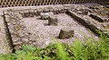
| Chingle Hall moated site | — | Whittingham 53°49′00″N 2°40′29″W / 53.8167°N 2.6746°W |
— | 13477 | Moat | [43] PS |
Ribble Valley edit
-

-
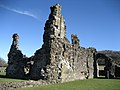
 High cross in St Mary's churchyard, Whalley
 -

-
 Old Lower Hodder Bridge
 -
 Ribchester Roman fort
 -


Rossendale edit
| Name | Remains | Location | Date | SM No [A] | Description | Ref(s) |
|---|---|---|---|---|---|---|
| Grane Mill early 20th century weaving mill power unit | Buildings and machinery | Haslingden 53°42′07″N 2°19′09″W / 53.7019°N 2.3191°W |
C. 20th | 34999 | The engine house, engine, boiler house, boilers and chimney of Grane Mill, operated 1907-1979. Machinery includes a Cross-compound engine, 2 Lancashire boilers and Green's Economiser. Is thought to be the only surviving complete, in situ mill power unit in Lancashire. Although a small project has been attempting to restore the site it is considered at risk. | [52][53][54][55] |
| Higher Mill, Helmshore | Buildings and machinery | Helmshore 53°41′24″N 2°20′19″W / 53.6899°N 2.3386°W 53°41′23″N 2°20′15″W / 53.6896°N 2.3375°W |
C. 18th | LA 143 | Water powered Wool finishing mill, operated 1789-1967. The present water wheel was installed around 1830 to replace 2 smaller ones. Other machinery includes fulling stocks, mangle, and tenter frame. Now part of Helmshore Mills Textile Museum. | [56][57][58][59] |
South Ribble edit
| Name | Remains | Location | Date | SM No [A] | Description | Ref(s) |
|---|---|---|---|---|---|---|
| Roman settlement | — | — | — | — | — | [60] |
West Lancashire edit
| Name | Remains | Location | Date | SM No [A] | Description | Ref(s) |
|---|---|---|---|---|---|---|
| Bickerstaffe Hall moated site | — | Bickerstaffe | — | — | Moat | [61] |
| Boar's Den bowl barrow | Earthworks | Wrightington | — | — | Bowl barrow | [62] |
| Burscough Priory | — | Burscough | — | — | — | [63] [64] |
| Cross Hall moated site | — | (east of) Ormskirk | — | — | Moat | [65] |
| Earthworks in Spa Roughs Wood | — | Lathom | — | — | — | [66] |
| Halsall medieval rectory | — | Halsall | — | — | Rectory | [67] |
| Rufford moated site | — | Rufford | — | — | Moat | [68] |
| Scarisbrick Hall moated site | — | Scarisbrick | — | — | Moat | [69] |
| Scarisbrick Park holy well | — | Scarisbrick | — | — | — | [70] |
| Scarisbrick Park wayside cross | — | Scarisbrick | — | — | — | [71] |
| Upholland Priory | — | Upholland | — | — | — | [72] LCC [73] |
| Wrightington Bridge | Bridge | Wrightington | — | — | — | [74] |
Wyre edit
| Name | Remains | Location | Date | SM No [A] | Description | Ref(s) |
|---|---|---|---|---|---|---|
| Bleasdale Circle enclosed Bronze Age urnfield | — | Bleasdale | — | — | — | [75] LCC |
Notes edit
- A SM No = Scheduled Monument Number
References edit
- Greenlane Archaeology. "2009 Project selection" (PDF). Rapid surveys for Lancashire County Council.
- Farrer and Brownbill (1908). The Victoria History of the County of Lancaster Vol 2. London: Victoria County History - Constable & Co. Retrieved 2011-05-16.
- Farrer and Brownbill (1911). The Victoria History of the County of Lancaster Vol 6. London: Victoria County History - Constable & Co. Retrieved 2011-05-16.
- ^ Historic England. "Coking ovens and associated coal workings on Aushaw Moss 450m south west of Lower House (1016937)". National Heritage List for England.
- ^ Historic England. "Aushaw Moss (1232234)". Research records (formerly PastScape). Retrieved 2012-01-1.
{{cite web}}: Check date values in:|access-date=(help) - ^ Historic England. "Part of Witton Old Hall medieval lordly residence 340m north east of Feniscliffe Bridge (1020459)". National Heritage List for England.
- ^ Historic England. "Witton Old Hall (43511)". Research records (formerly PastScape). Retrieved 2012-01-1.
{{cite web}}: Check date values in:|access-date=(help) - ^ VCH Lancaster 6 pp.263-266
- ^ a b c d Greenlane Archaeology rapid surveys
- ^ Historic England. "Pleasington alum works (1018652)". National Heritage List for England.
- ^ Historic England. "Pleasington alum works (1195251)". Research records (formerly PastScape). Retrieved 2012-01-1.
{{cite web}}: Check date values in:|access-date=(help) - ^ Historic England. "Roman road at Bottom o' th' Knotts Brow (1005099)". National Heritage List for England.
- ^ Historic England. "Steam tramway reversing triangle (1005096)". National Heritage List for England.
- ^ Historic England. "Steam tramway reversing triangle (43587)". Research records (formerly PastScape). Retrieved 2012-01-1.
{{cite web}}: Check date values in:|access-date=(help) - ^ "Scheduled Ancient Monument - Steam Railway", Archaeological Sites, Lancashire County Council
- ^ Historic England. "Stone circle, ring cairn and two round cairns on Cheetham Close (1009121)". National Heritage List for England.
- ^ Historic England. "Stone circle, ring cairn and two round cairns on Cheetham Close (44312)". Research records (formerly PastScape). Retrieved 2012-01-1.
{{cite web}}: Check date values in:|access-date=(help) - ^ Historic England. "Ightenhill Manor (site of) (1005100)". National Heritage List for England.
- ^ VCH Lancaster 6 pp.487-489
- ^ Historic England. "Oakmount Mill engine and engine house, Wiseman Street (1005084)". National Heritage List for England.
- ^ Historic England. "Thieveley lead mine 330m south west and 910m WSW of Buckleys (1021252)". National Heritage List for England.
- ^ Historic England. "Warren at Everage Clough 450m north east of New Copy Farm (1018362)". National Heritage List for England.
- ^ VCH Lancaster 6 pp.213-217
- ^ a b VCH Lancaster 6 pp.162-166
- ^ "Croston Town Bridge", National Heritage List for England, English Heritage
{{citation}}: Italic or bold markup not allowed in:|work=(help) - ^ VCH Lancaster 6 pp.29-32
- ^ Historic England. "Remains of Aspen Colliery, associated beehive coking ovens and canal basin (1016943)". National Heritage List for England.
- ^ Historic England. "Aspen Colliery (44445)". Research records (formerly PastScape). Retrieved 2012-01-1.
{{cite web}}: Check date values in:|access-date=(help) - ^ "Scheduled Ancient Monument - Aspen Colliery", Archaeological Sites, Lancashire County Council
- ^ VCH Lancaster 2 pp.524-526
- ^ VCH Lancaster 2 pp.529-531
- ^ VCH Lancaster 2 pp.526-528
- ^ VCH Lancaster 2 pp.521-523
- ^ VCH Lancaster 2 pp.154-159
- ^ "Hornby Bridge", National Heritage List for England, English Heritage
{{citation}}: Italic or bold markup not allowed in:|work=(help) - ^ VCH Lancaster 2 pp.167-173
- ^ VCH Lancaster 2 pp.508-511
- ^ VCH Lancaster 2 pp.545-546
- ^ Historic England. "Bank House Bridge, Wycoller (1005104)". National Heritage List for England.
- ^ Historic England. "Bank House Bridge, Wycoller (46147)". Research records (formerly PastScape). Retrieved 2012-01-1.
{{cite web}}: Check date values in:|access-date=(help) - ^ Anon. "Wycoller Clapper Bridges". Engineering Timelines.
- ^ Historic England. "Bomber Camp Romano-British farmstead (1013817)". National Heritage List for England.
- ^ Historic England. "Bomber Camp Romano-British farmstead (45451)". Research records (formerly PastScape). Retrieved 2012-01-1.
{{cite web}}: Check date values in:|access-date=(help) - ^ VCH Lancaster 2 pp.514-516
- ^ VCH Lancaster 6 pp.548-552
- ^ "Chingle Hall moated site", National Heritage List for England, English Heritage
{{citation}}: Italic or bold markup not allowed in:|work=(help) - ^ Historic England. "Bellmanpark lime kilns and part of an associated tramway 180m north west of Bellman Farm (1021105)". National Heritage List for England. Retrieved 15 September 2015.
- ^ Historic England. "Bellmanpark lime kilns (1405447)". Research records (formerly PastScape). Retrieved 15 September 2015.
- ^ Historic England. "Clitheroe Castle (1016196)". National Heritage List for England.
- ^ VCH Lancaster 2 pp.523-524
- ^ Historic England. "Paythorne Bridge (1005094)". National Heritage List for England.
- ^ Historic England. "Portfield hillfort (1013608)". National Heritage List for England.
- ^ VCH Lancaster 2 pp.511-513
- ^ VCH Lancaster 2 pp.131-139
- ^ Historic England. "Grane Mill early 20th century weaving mill power unit (1020996)". National Heritage List for England.
- ^ Historic England. "Grane Mill (1373678)". Research records (formerly PastScape). Retrieved 2012-01-1.
{{cite web}}: Check date values in:|access-date=(help) - ^ "Grane Mill early 20th century weaving mill power unit", Heritage at Risk Register, English Heritage
- ^ Grane Mill, Haslingden, The View From The North
- ^ Historic England. "Higher Mill, Helmshore (1005102)". National Heritage List for England.
- ^ Historic England. "Higher Mill, Helmshore (44455)". Research records (formerly PastScape). Retrieved 2012-01-1.
{{cite web}}: Check date values in:|access-date=(help) - ^ "Scheduled Ancient Monument - Higher Mill", Archaeological Sites, Lancashire County Council
- ^ "Helmshore Mills Textile Museum", Lancashire Museums, Lancashire County Council
- ^ "Roman settlement and industrial area at Winery Lane", National Heritage List for England, English Heritage
{{citation}}: Italic or bold markup not allowed in:|work=(help) - ^ "Moated site at Bickerstaffe Hall", National Heritage List for England, English Heritage
{{citation}}: Italic or bold markup not allowed in:|work=(help) - ^ "Boar's Den bowl barrow", National Heritage List for England, English Heritage
{{citation}}: Italic or bold markup not allowed in:|work=(help) - ^ "Burscough Priory", National Heritage List for England, English Heritage
{{citation}}: Italic or bold markup not allowed in:|work=(help) - ^ VCH Lancaster 2 pp.148-152
- ^ "Cross Hall moated site", National Heritage List for England, English Heritage
{{citation}}: Italic or bold markup not allowed in:|work=(help) - ^ "Earthworks in Spa Roughs Wood", National Heritage List for England, English Heritage
{{citation}}: Italic or bold markup not allowed in:|work=(help) - ^ "Halsall medieval rectory", National Heritage List for England, English Heritage
{{citation}}: Italic or bold markup not allowed in:|work=(help) - ^ "Rufford moated site", National Heritage List for England, English Heritage
{{citation}}: Italic or bold markup not allowed in:|work=(help) - ^ "Moated site of Scarisbrick Hall", National Heritage List for England, English Heritage
{{citation}}: Italic or bold markup not allowed in:|work=(help) - ^ "Scarisbrick Park holy well", National Heritage List for England, English Heritage
{{citation}}: Italic or bold markup not allowed in:|work=(help) - ^ "Scarisbrick Park wayside cross", National Heritage List for England, English Heritage
{{citation}}: Italic or bold markup not allowed in:|work=(help) - ^ "Upholland Priory", National Heritage List for England, English Heritage
{{citation}}: Italic or bold markup not allowed in:|work=(help) - ^ VCH Lancaster 2 pp.111-112
- ^ "Wrightington Bridge", National Heritage List for England, English Heritage
{{citation}}: Italic or bold markup not allowed in:|work=(help) - ^ "Bleasdale Circle enclosed Bronze Age urnfield", National Heritage List for England, English Heritage
{{citation}}: Italic or bold markup not allowed in:|work=(help)
External links edit
 Media related to Scheduled Ancient Monuments in Lancashire at Wikimedia Commons