Tropical Storm Debra was the second of two tropical storms to hit the United States in the 1978 Atlantic hurricane season. The fourth named storm of the season, Debra developed from the interaction between a high-altitude cold low and a lower tropical wave in the Gulf of Mexico. Forming on August 25, it was upgraded to Tropical Storm Debra based on data from a Hurricane Hunter aircraft. As Debra approached the coast, it attained peak winds of 60 mph (95 km/h). The storm made landfall on the coast of Louisiana, east of the Texas border. Two deaths were caused by the storm. Debra weakened as it moved inland and ultimately dissipated on August 29 over Arkansas.
 Tropical Storm Debra making its landfall on August 28. | |
| Meteorological history | |
|---|---|
| Formed | August 26, 1978 |
| Dissipated | August 29, 1978 |
| Tropical storm | |
| 1-minute sustained (SSHWS/NWS) | |
| Highest winds | 60 mph (95 km/h) |
| Lowest pressure | 1000 mbar (hPa); 29.53 inHg |
| Overall effects | |
| Fatalities | 2 confirmed |
| Damage | Minimal |
| Areas affected | Texas, Louisiana, Mississippi, Arkansas, Missouri, Illinois, Tennessee |
| IBTrACS | |
Part of the 1978 Atlantic hurricane season | |
Meteorological history edit

Tropical storm (39–73 mph, 63–118 km/h)
Category 1 (74–95 mph, 119–153 km/h)
Category 2 (96–110 mph, 154–177 km/h)
Category 3 (111–129 mph, 178–208 km/h)
Category 4 (130–156 mph, 209–251 km/h)
Category 5 (≥157 mph, ≥252 km/h)
Unknown
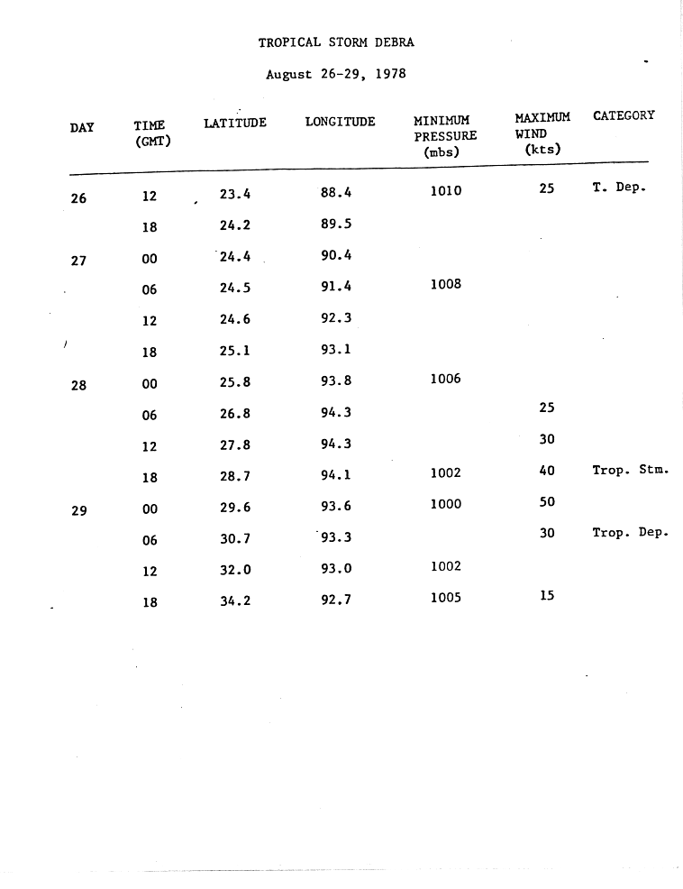
Debra originated in an upper-level cold-core low pressure system that developed over southwestern Florida in late August 1978. The low moved southwest towards the Yucatán Peninsula over the next day, as a tropical wave drifted westwards from the Caribbean Sea.[1] The interaction between the upper-level system and the wave led to the formation of a tropical depression on August 26 around 460 miles (740 km) south of New Orleans.[1][2]
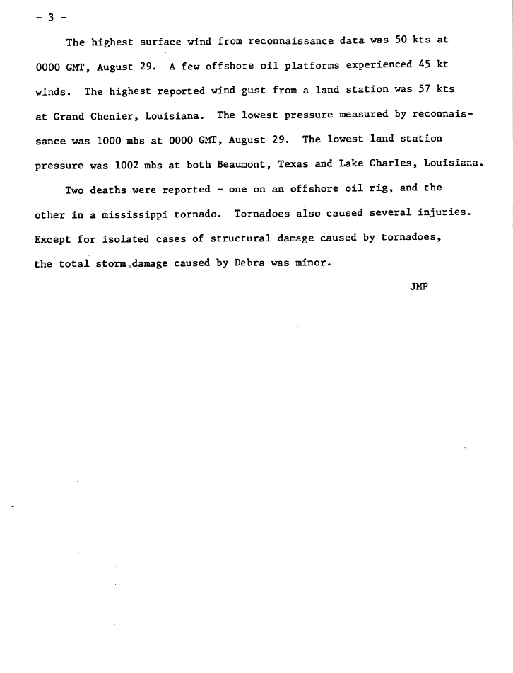
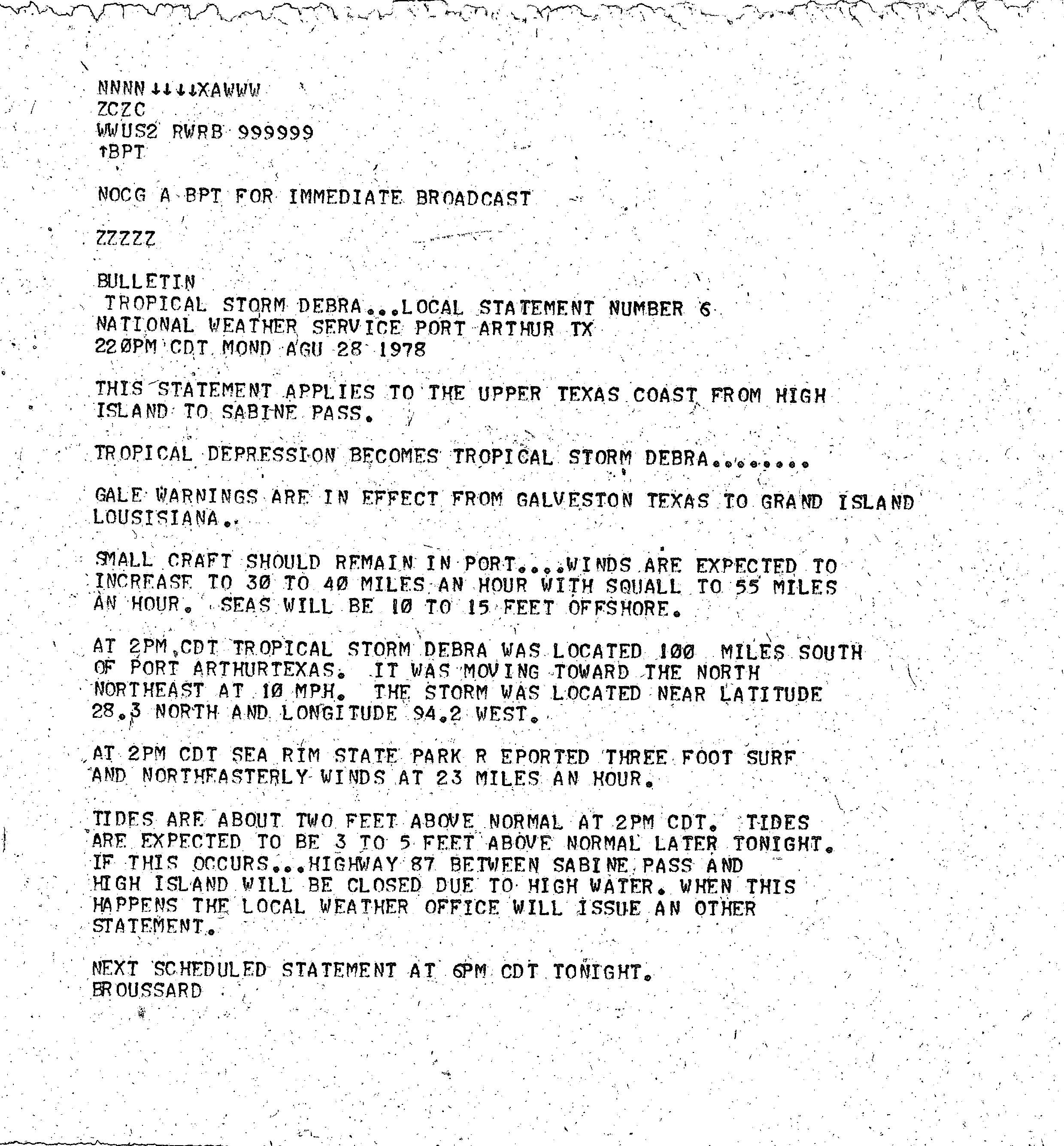
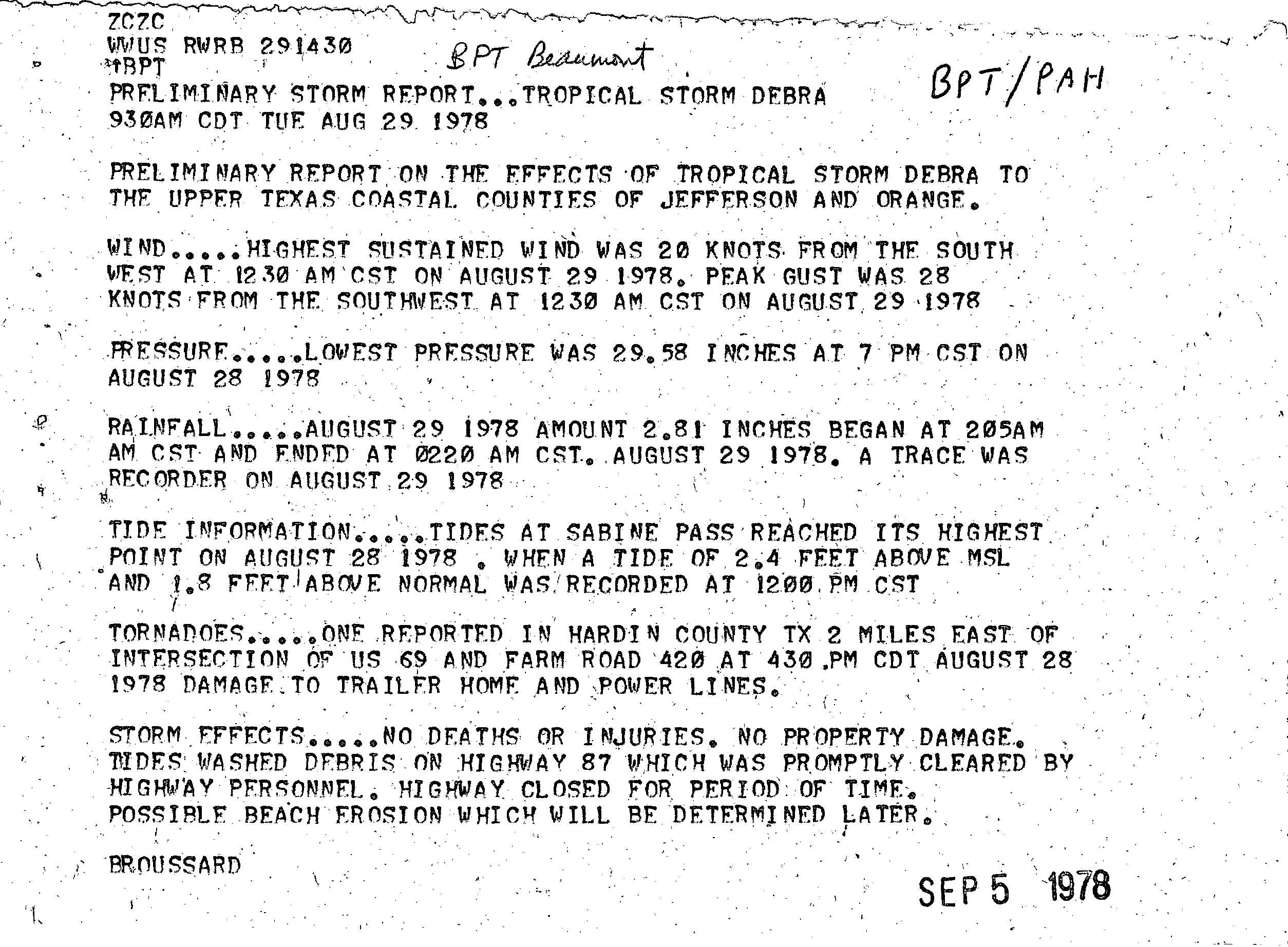
At first the depression drifted westward but, as the western periphery of a high-pressure area weakened, it tracked towards the north and slowly strengthened. After a reconnaissance aircraft found surface winds of 45 mph (70 km/h) on August 28, the depression was upgraded to Tropical Storm Debra. The aircraft also recorded a minimum pressure of 1002 mbar (hPa; 29.59 inHg).[1][2][3] While Debra approached the coast of Louisiana, an additional flight into the system found a drop in surface pressure to 1000 mbar (hPa; 29.53 inHg), as well as peak winds of approximately 60 mph (100 km/h) at 00:00 GMT on August 29.[1][2][4] Observation stations off the coast recorded sustained winds of 45–50 mph (70–80 km/h) on August 28, as Debra passed 150 miles (240 km) to the west.[2][3][4]
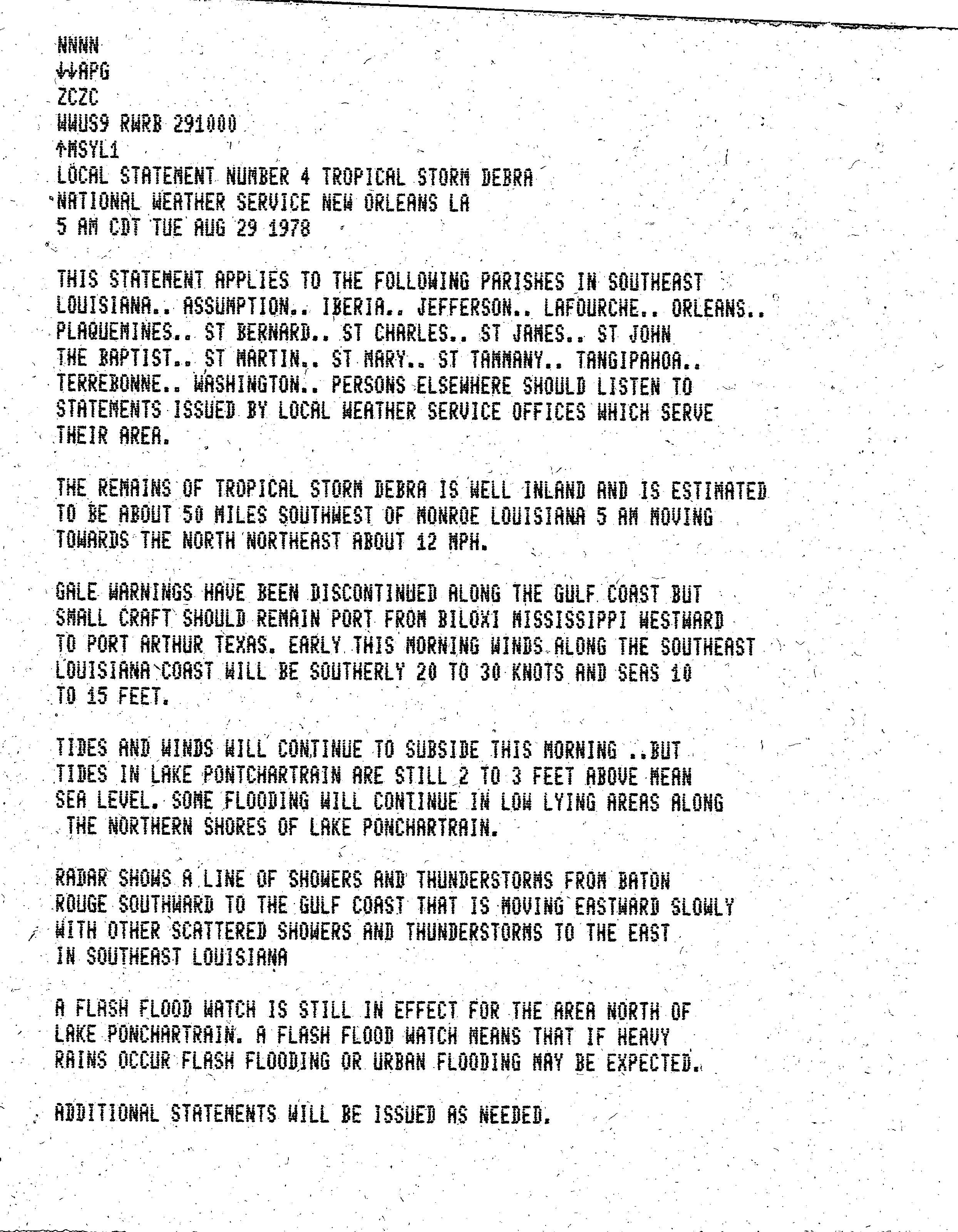
The storm made landfall between Beaumont, Texas, and Lake Charles, Louisiana, on August 28.[4] Two stations recorded surface pressures of 1002 mbar (hPa; (29.59 inHg)).[3] As Debra moved north-northeast through Louisiana and Arkansas, the central pressure rose slightly. In south central Arkansas the residual low pressure system merged with a frontal trough on August 29; the frontal wave drifted into southern Illinois and traveled eastbound into the Ohio Valley for the next three days.[2][4] Five tornadoes were reported from the system in Texas, Louisiana, and Mississippi shortly after Debra's landfall.[note 1]
Preparations and impact edit

Louisiana edit
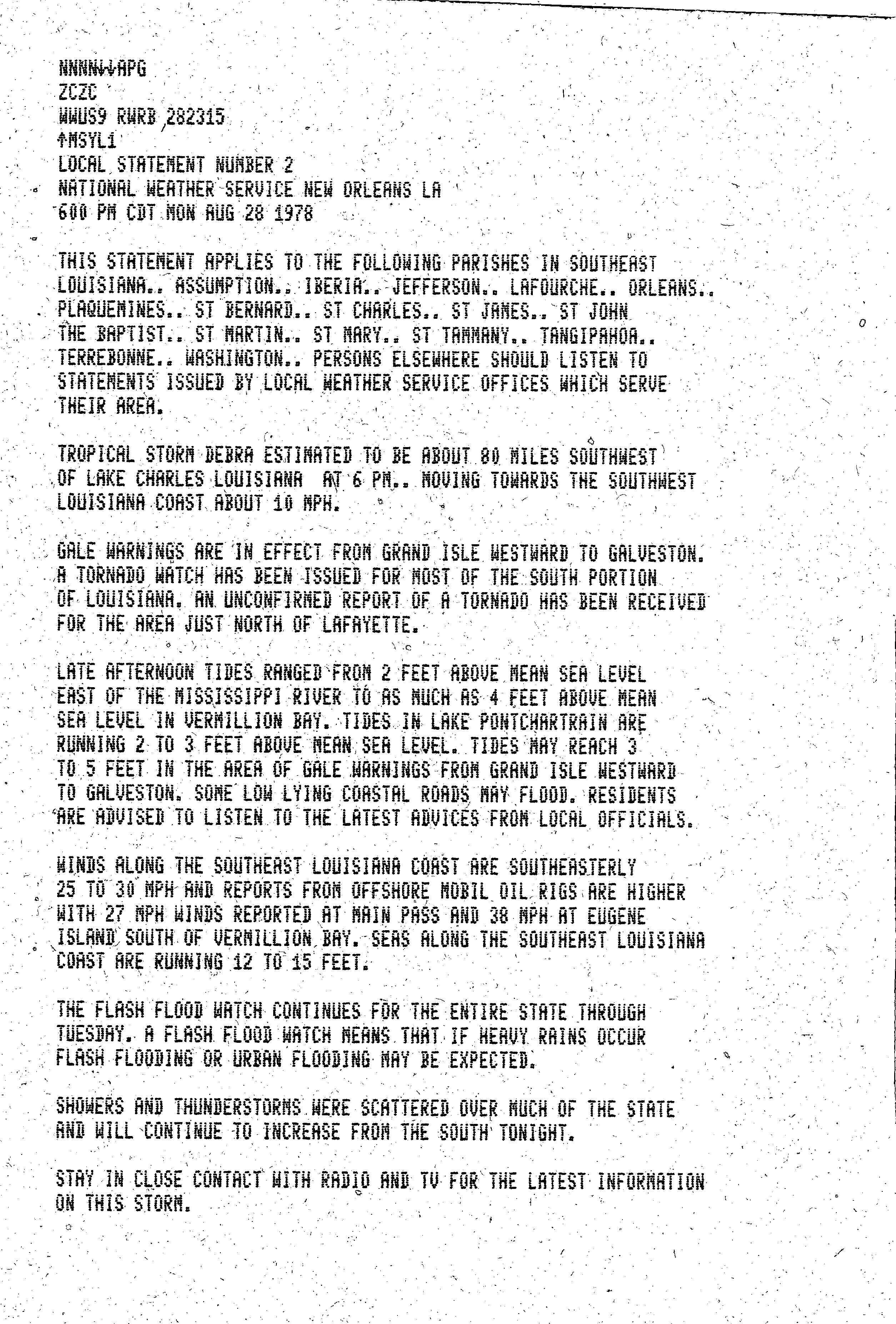
A flash flood watch was issued in advance of Debra for the whole of Louisiana.[11] ExxonMobil, Royal Dutch Shell, Chevron, and other oil companies shut down operations and evacuated about 1,000 employees from offshore oil rigs in Texas and Louisiana.[12][13] Despite these evacuations, a 15-foot (4.6 m) wave killed a person at a rig 80 miles (130 km) offshore from Cameron.[14][15] Three evacuation centers in Lake Charles, were set up to help those needing shelter and departing the Cameron area,[16] and the Red Cross opened four shelters at the Calcasieu Parish Public Schools.[12] In Louisiana, more than six thousand people were evacuated from Cameron Parish,[17][18] as well as an undetermined number from Vermilion Parish.[1]
Louisiana had moderate flooding, especially in Rapides Parish.[19] Rainfall amounted to 6 inches (15 cm) at Lake Charles and Lafayette, 3 inches (7.6 cm) at Shreveport, and 3.5 inches (8.9 cm) at Monroe.[20] Flash flood warnings were issued during the storm for Louisiana, Mississippi, Arkansas, Missouri, and Tennessee.[21] By dawn on August 29, all rainwater had receded from the streets and tides were back to normal levels.[20]
A confirmed tornado at the Ike settlement in Vernon Parish, knocked over a trailer.[4][17] The greatest amount of rainfall caused by Debra, 10.81 in (275 mm), was recorded in Freshwater Bayou Lock.[2][22] More than 6 in (150 mm) was recorded across Louisiana,[2][4][23] and tides between Atchafalaya Bay and Vermilion Bay were 5.7 ft (1.7 m) above normal.[2][4] At Grand Chenier, a wind gust of 65 miles per hour (105 km/h) to 70 miles per hour (110 km/h) was recorded,[15][16] and there were reports of downed trees and damage to roofs in Lake Charles and New Orleans.[13] Tides at Lake Pontchartrain were 2 feet (0.61 m) to 3 feet (0.91 m) above normal.[24]
Elsewhere edit
Gale warnings were prompted from Galveston, Texas, through to Grand Isle, Louisiana, at 18:00 GMT on August 28.[1][25] A confirmed tornado in Hardin County, Texas,[26] damaged a trailer home and power lines. More than 6 inches (150 mm) of rainfall was recorded within Texas[4] and 7 inches (180 mm) in the Beaumont – Port Arthur area caused minor street flooding.[14][19] Tides were 1 ft (0.30 m) above normal at Corpus Christi, while tides at Galveston were 2.2 ft (0.67 m) above normal.[2][4]
A tornado spawned in Turkey Creek, Mississippi, destroyed three mobile homes and a house, killing one person and seriously injuring another; this tornado tracked on to Crystal Springs, Mississippi.[27][28] Many rice stands were knocked over because of the gusts of wind from Tropical Storm Debra.[29] Rainfall of more than 6 in (15 cm) was recorded in locations across Mississippi, Missouri, and Illinois.[2][4][15] Tornadoes were reported in Memphis, Tennessee; Little Rock, Arkansas; Starkville, Springdale, Cedarbluff and Flora in Mississippi; Livingston and Ascension parishes[30] and north Lafayette in Louisiana.[11][31] One person was hurt in the Memphis tornado.[31] Power was knocked out at four blocks of the Memphis International Airport,[31] gas supplies were cut off in Memphis, and downed trees and power poles blocked many streets.[31] Overall damage caused by Debra was minimal.[17][32]
See also edit
Notes edit
Footnotes edit
Citations edit
- ^ a b c d e f Pelisser, Joseph M. (1978). "Tropical Storm Debra Preliminary Report". National Hurricane Center. National Oceanic and Atmospheric Administration. p. 1. Retrieved 2011-06-30.
- ^ a b c d e f g h i j Lawrence, Miles B. (1979-01-29). "Atlantic Hurricane Season of 1978". Monthly Weather Review. 107 (April 1979). American Meteorological Society: 482–483. Bibcode:1979MWRv..107..477L. doi:10.1175/1520-0493(1979)107<0477:AHSO>2.0.CO;2. ISSN 1520-0493.
- ^ a b c "Tropical Storm Debra Preliminary Report". National Hurricane Center. National Oceanic and Atmospheric Administration. 1978. p. 4. Retrieved 2011-07-01.
- ^ a b c d e f g h i j k l m Pelisser, Joseph M. (1978). "Tropical Storm Debra Preliminary Report". National Hurricane Center. National Oceanic and Atmospheric Administration. p. 2. Retrieved 2011-06-30.
- ^ "Tornado Climatology for Southeast Texas & Southwest Louisiana" (PDF). National Weather Service Central Region Headquarters. NWS Central Region Headquarters. Retrieved 2011-07-18.
- ^ "Tornado History Project: 19780828.48.128". Storm Prediction Center. Tornado History Project. Retrieved 2011-07-18.
- ^ "Tornado History Project: 19780828.22.14". Storm Prediction Center. Tornado History Project. Retrieved 2011-07-18.
- ^ "Tornado History Project: 19780829.28.10". Storm Prediction Center. Tornado History Project. Retrieved 2011-07-18.
- ^ "Tornado History Project: 19780829.5.35". Storm Prediction Center. Tornado History Project. Retrieved 2011-07-18.
- ^ "Tornado History Project: 19780829.47.7". Storm Prediction Center. Tornado History Project. Retrieved 2011-07-18.
- ^ a b "Local Statement Number 2". National Weather Service New Orleans, Louisiana. National Weather Service. Retrieved 2011-07-05.
- ^ a b "Tropical Storm Debra Brings Battening Down". Sarasota Herald-Tribune. 1978-08-29. Retrieved 2011-07-01.
- ^ a b "Storm Hits Louisiana". Spokane Daily Chronicle. 1978-08-29. Retrieved 2011-07-01.
- ^ a b "Tropical storm zeros in on Louisiana coast". St. Petersburg Times. 1978-08-29. Retrieved 2011-07-01.
- ^ a b c Pelisser, Joseph M. (1978). "Tropical Storm Debra Preliminary Report". National Hurricane Center. National Oceanic and Atmospheric Administration. p. 3. Retrieved 2011-06-30.
- ^ a b "Tropical storm slams into Texas, Louisiana". St. Petersburg Times. 1978-08-29. Retrieved 2011-07-01.
- ^ a b c "Tropical Storm Debra Headed For Arkansas". The Evening Independent. 1978-08-29. Retrieved 2011-07-01.
- ^ "Nation's weather". Daily News. 1978-08-29. Retrieved 2011-07-01.
- ^ a b "Tropical Storm Debra Weakens, Moves Inland". Toledo Blade. 1978-08-29. Retrieved 2011-07-01.
- ^ a b "Debra brings threat of tornadoes, floods". Daily Union. 1978-08-29. Retrieved 2011-07-01.
- ^ "'Debra' makes devastating exit". Bangor Daily News. 1978-08-30. Retrieved 2011-07-06.
- ^ Roth, David. "Tropical Storm Debra 1978". Hydrometeorological Prediction Center. Retrieved 2011-06-30.
- ^ "Debra Produces Tornadoes, Rain". The Victoria Advocate. 1978-08-29. Retrieved 2011-06-30.
- ^ "Local Statement Number 4". National Weather Service New Orleans, Louisiana. National Weather Service. Retrieved 2011-07-05.
- ^ "Local Statement Number 6". National Hurricane Center tropical cyclone reports. National Hurricane Center. Retrieved 2011-07-05.
- ^ "Preliminary Storm Report – Tropical Storm Debra 930AM CDT TUE AUG 29 1978". National Weather Service. National Weather Service. Retrieved 2011-07-17.
- ^ "Debra Spawns Tornadoes: 1 Killed, Dozens Hurt". The News-Dispatch. 1978-08-30. Retrieved 2011-07-01.
- ^ "Debra lumbers inland, causes minor flooding". The Deseret News. 1978-08-29. Retrieved 2011-07-01.
- ^ "Mississippi Weather & Crop Report 1969-1978" (PDF). National Agricultural Statistics Service. United States Department of Agriculture. p. 13. Archived from the original (PDF) on 2011-10-24. Retrieved 2011-07-18.
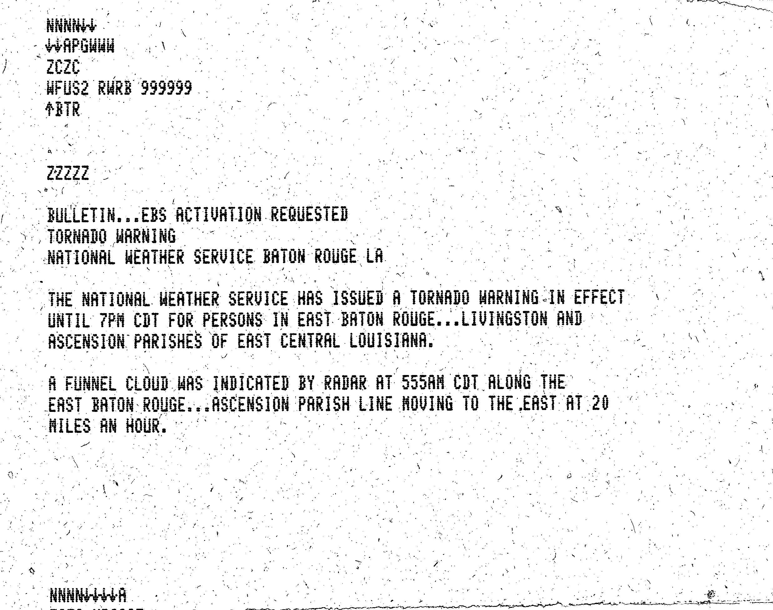
- ^ "TORNADO WARNING – WFUS2 RWSB 999999". National Weather Service Baton Rouge, Louisiana. National Weather Service.
- ^ a b c d "Woman dies; Elvis Boulevard hit: Spent Debra sends tornadoes through South". Eugene Register-Guard. 1978-08-30. Retrieved 2011-07-01.
- ^ "In the aftermath of Debra". St. Petersburg Times. 1978-08-30. Retrieved 2011-07-01.