Trevenson (Cornish: Trevensyn)[1] is in the parish of Carn Brea, between the towns of Camborne and Redruth in Cornwall, United Kingdom.


Trevenson House edit
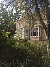
Trevenson House was built in 1797 for Thomas Kevill, a steward of the Tehidy estate and replaced an earlier house on the site. Trevenson House is a Grade II listed building. Further information regarding the history can be found here. [2] It is now part of iCT4 Limited[3] being run as serviced offices and conferencing facilities for the community.
Trevenson Chapel edit
Tevenson Chapel was built in 1806–09 as a Church of England chapel-of-ease in the parish of Illogan. The chapel has a thin castellated west tower; the pointed windows are of granite with cast iron tracery. This tracery has been replaced with modern replicas.[4][5]
Education edit
The area is home to Cornwall College, an A level centre and Pool School. Trevenson used to be home to the Camborne School of Mines between 1970 and 2004. It has since moved to a new campus in Penryn called Tremough.
Cornish wrestling edit
Trevenson Park was the venue for Cornish wrestling tournaments for prizes[6] including the Interceltic games in 1929.[7]
References edit
- ^ Place-names in the Standard Written Form (SWF) : List of place-names agreed by the MAGA Signage Panel. Cornish Language Partnership.
- ^ "TREVENSON HOUSE, CAMBORNE POOL REDRUTH COLLEGE, Carn Brea - 1392498 | Historic England". historicengland.org.uk. Retrieved 3 May 2020.
- ^ "Conferencing & meeting space in Camborne Pool Redruth". Trevenson House. Retrieved 3 May 2020.
- ^ Pevsner, N. (1970) Cornwall; 2nd ed., revised by Enid Radcliffe. Harmondsworth: Penguin; p. 143
- ^ St Illogan; Trevenson Church History
- ^ West Briton and Cornwall Advertiser, 15 July 1937.
- ^ Western Morning News, 2 September 1929.
50°13′48″N 5°16′23″W / 50.230°N 5.273°W
