Talk:Territorial evolution of the United States/Archive 3
| This is an archive of past discussions. Do not edit the contents of this page. If you wish to start a new discussion or revive an old one, please do so on the current talk page. |
| Archive 1 | Archive 2 | Archive 3 | Archive 4 | Archive 5 | → | Archive 7 |
Minor islands
OK I decided to go all in and make maps for the minor claims. I don't know yet if they should show up in the main list, but it's getting done. So here is where that timeline goes.
- 1856-10-28: Baker's/Nantucket/New Nantucket, Jarvis bonded.
- 1858-??-??: Sand Island, part of Midway, bonded? [1]
- 1858-08-31: Navassa bonded.
- 1858-12-03: Howland/Nowlands bonded.
- 1859-09-06: Johnson's Is. bonded.
- 1859-12-27: Barren/Starve, Enderbury, McKean, Phoenix bonded.
- 1859-12-29: Christmas, Malden's Is. bonded.
- 1860-02-08: America Is., Anne's, Barber's, Bauman's, Birnies', Caroline, Clarence, Dangerous Is., Dangers Rock, David's, Duke of York, Enderbury's [phantom], Farmer's, Favorite, Flint [phantom], Flint's, Frances, Frienhaven, Gallego, Ganges, Gardners, Gronique, Humphrey's, Kemn's, Liderons, Low Is., Mackin/Makin, Mary Letitia's, Mary's/Canton, Mathews, Nassau, Palmyros, Penhuyn's, Pescado, Phoenix [again], Prospect, Quiros, Rierson's, Rogewein's Is., Samarang Is., Sarah Anne, Sidney's, Starbuck/Hero, Staver's/Vostok, Walkers, Washington bonded.
- 1862-12-30: Swan Is. (incl. Great and Little) bonded.
- 1868-08-12: "Islands in Caribbean Sea not named" bonded.
- 1868-12-11: Serrana bonded.
- 1869-11-22: Pedro Keys, Petrel, Quito Sereno, Roncador bonded.
- 1879-09-08: Arenas Key, Morant Keys (incl Northeast Key, Sand Keys, Savanna Key, Seal Key), Serrannilla Keys (incl East Key, Middle Key, Beacon Key) bonded.
- 1880-09-13: De Anes, Serrannilla Keys (incl East Key, Middle Key, Beacon Key) again, Western Triangles bonded.
- 1880-10-18: Arenas bonded.
- 1884-06-21: Alacrans Is., incl. Chica, Pajoras, and Perez, bonded.
- 1888-03-15: Fanning annexed by UK
- 1889-05-29: Washington annexed by UK
- 1894-11-17: Arenas, Arenas Key, Alacrans Is., Western Triangles stricken.
- 1939-08-16: Earliest known date for claim on Fakaofo, Funafuti, Hull Island, Niulakita, Nukufetau, Nukulaelae.
- 1981-09-17: Quita Sueno, Roncador, Serrana ceded to Colombia.
- 1983-09-03: Atafu, Fakaofo, Nukunono ceded to Tokelau.
- 1983-09-08: Danger, Manahiki, Penrhyn, Rakahanga ceded to Cook Islands.
- 1983-09-23: Birnie, Canton, Caroline, Christmas, Enderbury, Flint, Gardner, Hull, Malden, McKean, Phoenix, Starbuck, Sydney, Vostok ceded to Kiribati. Funafuti, Nukefetau, Nukulaelae, Nurakita ceded to Tuvalu.
On an island by island basis:
- Alacrans: Jun 21 1884-Nov 21 1894 [stricken]
- Anne's: see Vostok
- Arenas Key: Sep 8 1879-Nov 21 1894 [stricken]
- Arenas: Oct 18 1880-Nov 21 1894 [stricken]
- Atafu: Feb 8 1860 [as Duke of York]-Sep 3 1983 [to Tokelau]
- Baker: Oct 28 1856-present
- Bajo Nuevo: Nov 22 1869-present
- Barber's: Appears to be phantom. 8 54 N, 178 W
- Barren: see Starbuck
- Bauman's: Appears to be phantom. 11 48 S 154 10 W
- Birnie: Feb 8 1860-Sep 23 1983 [to Kiribati]
- Canton: Feb 8 1860-Sep 23 1983 [to Kiribati]
- Caroline: Feb 8 1860-Sep 23 1983 [to Kiribati]
- Christmas: Dec 29 1859-Sep 23 1983 [to Kiribati]
- Clarence: see Nukunono
- Dangers Rock: see Kingman
- Dangerous: Coordinates [10 S 165 56 W] are 60 miles from Pukapuka, formerly known as Danger Island. Consider this to mean that. Feb 8 1860-Sep 8 1983 [to Cook]
- David's: Appears to be phantom. 0 40 N 170 10 W
- De Ane's: Appears to be phantom. 15 40 N 63 37 W
- Duke of York: see Atafu
- Enderbury: Dec 27 1859-Sep 23 1983 [to Kiribati]
- Enderbury's: Appears to be phantom. 3 8 S 174 14 W
- Fakaofo: UNKNOWN ACQUISITION, earliest known date Aug 16 1939-Sep 3 1983 [to Tokelau]
- Fanning: Feb 8 1860 [as America]-Mar 15 1888 [annexed by UK]
- Farmer's: Appears to be phantom. 3 S 170 50 W
- Favorite: Appears to be phantom. 2 50 S 176 40 W
- Flint: Two entries. "Flint" is phantom at 10 32 S 162 05 W. "Flint's" is genuine. Feb 8 1860-Sep 23 1983 [to Kiribati]
- Frances: Appears to be phantom. 9 58 S 161 40 W
- Frienhaven: Appears to be phantom. 10 S 156 59 W
- Funafuti: UNKNOWN ACQUISITION, earliest known date Aug 16 1939-Sep 3 1983 [to Tuvalu]
- Gallego: Appears to be phantom. 1 42 N 104 05 W
- Ganges: see Manihiki
- Gardner: Feb 8 1860-Sep 23 1983 [to Kiribati]
- Gronique: Appears to be phantom. 10 S 154 44 W
- Howland: Dec 3 1858-present
- Hull: UNKNOWN ACQUISITION, earliest known date Aug 16 1939-Sep 23 1983 [to Kiribati]]
- Humphrey's: see Manihiki
- Jarvis: Oct 28 1856-present
- Johnson: Sep 6 1859-present
- Kemn's: Appears to be phantom. 4 41 S 173 44 W
- Kingman: Feb 8 1860 [as Dangers Rock]-present
- Liderons: see Manihiki
- Low: Appears to be phantom but is 30 miles from Fakaofo. 9 33 S 170 38 W
- Mackin: Feb 8 1860-UNKNOWN CESSION, latest known Mar 3 1892 (UK made Gilberts protectorate), is now part of Kiribati as Butaritari
- Malden: Dec 29 1859-Sep 23 1983 [to Kiribati]
- Manihiki: Feb 8 1860 [as Ganges and Humphrey's and Liderous and Pescado: [2] states these were early names]-Sep 8 1983 [to Cook]
- Mary Letitia's: Appears to be phantom. 4 40 S 173 20 W
- Mary's: see Canton
- Mathews: Feb 8 1860-UNKNOWN CESSION, latest known Mar 3 1892, but is now part of Kiribati as Maraki
- McKean: Dec 27 1859-Sep 23 1983 [to Kiribati]
- Morant Keys: Bonded Sep 8 1879; claimed by UK 1862, annexed to Jamaica 1882.
- Nassau: Feb 8 1860-Sep 8 1983 [It was not named in the treaty that ceded the other Cook Islands. but I think it may have been parceled with Pukapuka]
- Navassa: Aug 31 1858-present
- Nukefetau: UNKNOWN ACQUISITION, earliest known date Aug 16 1939-Sep 23 1983 [to Tuavlu]
- Nukulaelae: UNKNOWN ACQUISITION, earliest known date Aug 16 1939-Sep 23 1983 [to Tuvalu]
- Nukunono: Coordinates for Clarence (9 07 S 171 40 W) are 8 miles east of Nukunono. Nukunono and Atafu used to be called the "Duke of Clarence Group" so taking this to mean at least Nukunono. Feb 8 1860 [as Clarence]-Sep 3 1983 [to Tokelau]
- Nurakita: UNKNOWN ACQUISITION, earliest known date Aug 16 1939-Sep 23 1983 [to Tuvalu]
- Palmyra: Feb 8 1860-Apr 15 1862 [annexed by Hawaii]-present
- Pedro Keys: Assuming this to mean Pedro Bank since we don't have coordinates, which means bonded Nov 22 1869 but claimed by UK in 1863 and annexed to Jamaica in 1882.
- Penrhyn: Feb 8 1860-Sep 8 1983 [to Cook]
- Pescado: see Manihiki
- Petrel: see Bajo Nuevo
- Phoenix: Dec 27 1859 [at 3 47 S 170 55 W]-Feb 8 1860 [at 3 40 S 170 52 W]-Sep 23 1983 [to Kiribati]
- Prospect: Appears to be phantom. 4 42 N 161 38 W
- Quiros: see Swains
- Quito Sereno: Nov 22 1869-Sep 17 1981 [to Colombia]
- Rakahanga: Feb 8 1860 [as Rierson]-Sep 8 1983 [to Cook]
- Rierson's: see Rakahanga
- Rogewein: Appears to refer to the whole chain of the northern Cook Islands, so ignoring.
- Roncador: Nov 22 1869-Sep 17 1981 [to Colombia]
- Samarang: Appears to be phantom. 5 10 N 162 20 W
- Sand [part of Midway]: 1858-present ([3] says "The Midway Islands were annexed in 1867, except Sand Island, which was claimed in 1858 under the Guano Islands act")
- Sarah Anne: Feb 8 1860-1917 [article in 1932 reports it was last seen "15 years earlier"; is now submerged]
- Serrana: Dec 11 1868-Sep 17 1981 [to Colombia]
- Serrannilla Keys: Sep 8 1879-Sep 13 1880 [again]-present
- Sidney's: see Sydney
- Starbuck: Dec 27 1859 [as Barren/Starve]-Feb 8 1860 [as Starbuck/Hero]-Sep 23 1983 [to Kiribati].
- Starve: see Starbuck
- Staver: see Vostok
- Swains: Feb 8 1860-present?
- Swan: Feb 8 1860-Sep 1 1972 [to Honduras]
- Sydney: Feb 8 1860 [as Sidney's]-Sep 23 1983 [to Kiribati]
- Vostok: Feb 8 1860-Sep 23 1983 [to Kiribati]
- Walker's: Appears to be phantom. 3 58 N 149 10 W
- Washington: Feb 8 1860-May 29 1889 [annexed by UK]
- Western Triangles: Sep 13 1880-Nov 21 1894 [stricken]
- Other Caribbean Islands: Aug 12 1868-???? any idea what this means
Of course much needs to be added to this but this is the start. --Golbez (talk) 16:09, 8 June 2015 (UTC)
- Quita Sueno Roncador, and Serrana were not occpuied by Colombia until the treaty was implemented in 1981, prior to that date they were actively occupied, under the control of control, and administered by US authorities. After the 1981 treaty, administration was handed over to the Colombians. Any colombian presence was ejected in 1919 when the Federal government assumed jurisdiction from the proprietary American owner (the guano act claimant). From 1890 to 1919 there was a colombian presence on the islands intermittantly. Prior to 1890, the American guano claimant occupied the islands.
- The Canton and Enderbury islands were under american occupation and administration up until the treaty was implemented in 1981 (the British actually abandoned the islands in 1971). Similarly Hull Island was administered and controlled by the Americans from 1971 until the treaty was implemented, (by the American administration at the Canton - Enderbury islands Condominium). See Digest of United States in International Law (1979) page 783. Some of the Phoenix islands in question (McKean most notably) were administered by no one at the time the treaty went into effect. See Chapter 6 of Digest of United States in International Law (1980) for a good history of American claims and presence in the islands (note though that any conclusions of law are the opinion of the author).XavierGreen (talk) 23:41, 8 June 2015 (UTC)
- re Colombia: Thanks, I was just assuming all guano islands were the US claiming and others running. re Kiribati: Ugh. Hm. Unfortunately, absent any specific dates for when a particular island was administered or not administered, I'm ... ok, for the guano islands, I'm going with claims then, not administration. Obviously, since the US surrendered 99% of them, their claim was eventually lesser than whoever it went to. hm. --Golbez (talk) 02:15, 9 June 2015 (UTC)
- Well for the pacific claims the 1980 edition of Digest of United States Practice in International Law states that the American claim was clearly inferior to the British in all cases except for 5, the Canton and Endenbury Islands (where the US had sole defacto occupation in 1979), Hull Island (again occupied defacto solely by the US in 1979), Christmas Island (which was occupied by the US from 1941 - 1948, and intermittantly alongside the british afterwords though the british asserted full sovereignty in the 1950's), and McKean (the source states that American and British claims were both poor, as British had never occupied the island and Americans hadnt occupied since 1877). For the Canton-Edenbury Islands Condominium and Hull island, i can get you specific dates that the administration regimes were established and ended if you like.XavierGreen (talk) 02:38, 9 June 2015 (UTC)
- Digest of United States Practice in International Law (1906) page 759 states certificate (acknowledging the claim is valid) issued for Serrano (Aka Serrana Bank) issued on December 11, 1868.XavierGreen (talk) 03:51, 9 June 2015 (UTC)
- re Colombia: Thanks, I was just assuming all guano islands were the US claiming and others running. re Kiribati: Ugh. Hm. Unfortunately, absent any specific dates for when a particular island was administered or not administered, I'm ... ok, for the guano islands, I'm going with claims then, not administration. Obviously, since the US surrendered 99% of them, their claim was eventually lesser than whoever it went to. hm. --Golbez (talk) 02:15, 9 June 2015 (UTC)
Xavier, do you know anything about the near-duplicate records? The digest of international law mentions "Enderbury" at 3 08 S, 171 08 W, which matches Enderbury Island. But it also lists "Enderbury's" at 3 08 S, 174 14 W, which is not near any island; it's closest to McKean, which is otherwise mentioned. I'm guessing that due to the name and location this might be a phantom island? Same deal with Flint (phantom) and "Flint's" (real). --Golbez (talk) 04:22, 9 June 2015 (UTC)
- Also, Hull Island was apparently not a guano claim, the best I can see is our article says the US occupied it in 1970. Any ideas? --Golbez (talk) 04:28, 9 June 2015 (UTC)
- Finally for tonight: Any idea when Funafuti, Nukefetau, Nukulaelae, and Nurakita were bonded or claimed? --Golbez (talk) 04:35, 9 June 2015 (UTC)
- Most of these Pacific island claims were filed under names that are not in use today, and in many instances were not even the ones used prior to those currently used. A handful of them actually are phantom islands (most of these are on one particular bond), or may have had the wrong coordinates filed. Digest of US Practice in Intenational Law (1980) page 443 states that a guano bond for Hull island was filed in 1859 or 1860. I'll do some digging around tomorrow if i have time to try to sort out which claims go with which island though as a last restort the latitude longitude should give some idea. Also all 25 pacific islands were stated as being US possesions in a diplomatic note sent to Britain in 1939. If you want that date, i think its in the 1979 issue of DUSPIL.XavierGreen (talk) 05:04, 9 June 2015 (UTC)
- I dunno; these might not be guano islands. Quoting Van Zandt, "All except the four in the Ellice Group (Funafuti, Nukufelau, Nukulailai, and Nurakita), Hull in the Phoenix group, and Fakaofu in the Union group, appear on lists of guano islands." --Golbez (talk) 13:45, 9 June 2015 (UTC)
- The 1979 and 1980 volumes of DUSPIL state that claims in the elice group were based primarily on discovery but it does not state if there were guano act claims. As for Hull island, some of the islands claimed in 1860 are within a few degrees of the island, and as i noted above DUSPIL 1980 states it was claimed in 1859 or 1860 under the act. I cannot find any reference to a guano claim for Fakaofu, and this claim is apparantly based on discovery as well. It would seem then that the American claim officially begins for these islands when the 1939 diplomatic note to Britain is issued. Some if not all of these islands were subsequently occupied by the american government during World War Two, but returned to british administration afterwords. A footnote can be included stating that Hull may have been claimed in 1859 or 1860 per DUSPIL 1980. Here is a source stating that the elice islands were not subject to guano claims. [[4]].XavierGreen (talk) 19:16, 9 June 2015 (UTC)
- I've decided on a new method of handling the maps that will make this easier: Split into four maps. One is "central North America", ie the 48 states. Just that. No insets. No nothing. Next is the Pacific region, then the Caribbean region, and finally northwestern North America (for Alaska and Oregon Country). This means that 1) Don't have to deal with all the insets in the 'main' view, 2) Each region can be developed separately, since we have far more information on north america than we do on the two marine regions, and 3) the maps will be much cleaner. So, this means that I can continue working on the map while the guano islands are in the air, but it also means that we cna be a little more waffly on some start dates. Basically, for the islands that we have zero start information I will just set their start date when the Guano Act came into effect, with a note explaining. But my main issue now isn't so much not knowing when an island was claimed, but not knowing when an island was abandoned. [Finally, doesn't a guano island claim require some kind of executive action? surely records of this would exist somewhere...?] --Golbez (talk) 20:07, 9 June 2015 (UTC)
- I think the four map solution will work very well. For the Carribean islands, the abandonment dates are pretty clear. Some of the pacific islands i have years for but not dates, others are quite vague. For Hull, Canton, Edenbury, i have exact dates. As for executive action, case law has stated that approval of the bond is sufficent executive action to make a guano island claim valid (ie, the island will be considered a possesion if it is bonded). Some older sources will state that the claim must also be certified by the Executive (through the state department), but the case law i mentioned stated that merely being bonded was sufficient. As i stated before, i can get you the exact date of the 1939 diplomatic note, but it will take a few days.XavierGreen (talk) 20:15, 9 June 2015 (UTC)
- Fortunately, the Pacific ceases to be interesting before 1898, meaning we can waffle all we want on dates and such before then, especially if we don't have to tie it in to the larger map. But, that's why I care more about the 'end' dates than the 'start' dates, because the end dates all come after that 1898 sweet spot. --Golbez (talk) 21:29, 9 June 2015 (UTC)
- Hmm, well i am a tad confused. Which end dates are you looking for. The end to effective american occupation of each individual island (for the world war two era occupations this is likely findable, but may be quite difficult to find exact dates) or the end of the american claim to each island (which would be the three treaties).XavierGreen (talk) 21:39, 9 June 2015 (UTC)
- The end to the claim; I guess I wasn't sure if the four treaties (Kiribati, Cook, Tokelau, Tuvalu) handled all of the islands that were bonded, that weren't otherwise kept. [Incidentally, do you know where to find a copy of the Treaty of Friendship with Tuvalu? I can't find a copy anywhere on the Internet] I don't care about occupation, just claims in this case, since occupation/administration is so vague with many of these islands. --Golbez (talk) 21:46, 9 June 2015 (UTC)
- If you have access to "United States Treaties and Other International Agreements" it is listed in that publication, which unfortunately i do not have in a format that is readily transmittable at the moment (i have database access to it). If you have a specific question about it i can try to answer it for you.XavierGreen (talk) 22:17, 9 June 2015 (UTC)
- Also Quiros Island is and old name for Swains Island [[5]]XavierGreen (talk) 22:25, 9 June 2015 (UTC).
- The end to the claim; I guess I wasn't sure if the four treaties (Kiribati, Cook, Tokelau, Tuvalu) handled all of the islands that were bonded, that weren't otherwise kept. [Incidentally, do you know where to find a copy of the Treaty of Friendship with Tuvalu? I can't find a copy anywhere on the Internet] I don't care about occupation, just claims in this case, since occupation/administration is so vague with many of these islands. --Golbez (talk) 21:46, 9 June 2015 (UTC)
- Hmm, well i am a tad confused. Which end dates are you looking for. The end to effective american occupation of each individual island (for the world war two era occupations this is likely findable, but may be quite difficult to find exact dates) or the end of the american claim to each island (which would be the three treaties).XavierGreen (talk) 21:39, 9 June 2015 (UTC)
- Fortunately, the Pacific ceases to be interesting before 1898, meaning we can waffle all we want on dates and such before then, especially if we don't have to tie it in to the larger map. But, that's why I care more about the 'end' dates than the 'start' dates, because the end dates all come after that 1898 sweet spot. --Golbez (talk) 21:29, 9 June 2015 (UTC)
- I think the four map solution will work very well. For the Carribean islands, the abandonment dates are pretty clear. Some of the pacific islands i have years for but not dates, others are quite vague. For Hull, Canton, Edenbury, i have exact dates. As for executive action, case law has stated that approval of the bond is sufficent executive action to make a guano island claim valid (ie, the island will be considered a possesion if it is bonded). Some older sources will state that the claim must also be certified by the Executive (through the state department), but the case law i mentioned stated that merely being bonded was sufficient. As i stated before, i can get you the exact date of the 1939 diplomatic note, but it will take a few days.XavierGreen (talk) 20:15, 9 June 2015 (UTC)
- I've decided on a new method of handling the maps that will make this easier: Split into four maps. One is "central North America", ie the 48 states. Just that. No insets. No nothing. Next is the Pacific region, then the Caribbean region, and finally northwestern North America (for Alaska and Oregon Country). This means that 1) Don't have to deal with all the insets in the 'main' view, 2) Each region can be developed separately, since we have far more information on north america than we do on the two marine regions, and 3) the maps will be much cleaner. So, this means that I can continue working on the map while the guano islands are in the air, but it also means that we cna be a little more waffly on some start dates. Basically, for the islands that we have zero start information I will just set their start date when the Guano Act came into effect, with a note explaining. But my main issue now isn't so much not knowing when an island was claimed, but not knowing when an island was abandoned. [Finally, doesn't a guano island claim require some kind of executive action? surely records of this would exist somewhere...?] --Golbez (talk) 20:07, 9 June 2015 (UTC)
- The 1979 and 1980 volumes of DUSPIL state that claims in the elice group were based primarily on discovery but it does not state if there were guano act claims. As for Hull island, some of the islands claimed in 1860 are within a few degrees of the island, and as i noted above DUSPIL 1980 states it was claimed in 1859 or 1860 under the act. I cannot find any reference to a guano claim for Fakaofu, and this claim is apparantly based on discovery as well. It would seem then that the American claim officially begins for these islands when the 1939 diplomatic note to Britain is issued. Some if not all of these islands were subsequently occupied by the american government during World War Two, but returned to british administration afterwords. A footnote can be included stating that Hull may have been claimed in 1859 or 1860 per DUSPIL 1980. Here is a source stating that the elice islands were not subject to guano claims. [[4]].XavierGreen (talk) 19:16, 9 June 2015 (UTC)
- I dunno; these might not be guano islands. Quoting Van Zandt, "All except the four in the Ellice Group (Funafuti, Nukufelau, Nukulailai, and Nurakita), Hull in the Phoenix group, and Fakaofu in the Union group, appear on lists of guano islands." --Golbez (talk) 13:45, 9 June 2015 (UTC)
- Most of these Pacific island claims were filed under names that are not in use today, and in many instances were not even the ones used prior to those currently used. A handful of them actually are phantom islands (most of these are on one particular bond), or may have had the wrong coordinates filed. Digest of US Practice in Intenational Law (1980) page 443 states that a guano bond for Hull island was filed in 1859 or 1860. I'll do some digging around tomorrow if i have time to try to sort out which claims go with which island though as a last restort the latitude longitude should give some idea. Also all 25 pacific islands were stated as being US possesions in a diplomatic note sent to Britain in 1939. If you want that date, i think its in the 1979 issue of DUSPIL.XavierGreen (talk) 05:04, 9 June 2015 (UTC)
- Finally for tonight: Any idea when Funafuti, Nukefetau, Nukulaelae, and Nurakita were bonded or claimed? --Golbez (talk) 04:35, 9 June 2015 (UTC)
- Xavier, please examine my list above. You're right - virtually every island survived until the treaties of the late 20th. But we still have a few gaps. --Golbez (talk) 05:32, 10 June 2015 (UTC)
- I finally got the date of the diplomatic note that asserted claims to the 25 pacific islands mentioned in the four treaties. It's August 16, 1939. It can be found in Foreign Relations Volume 2 (1939) page 317. It is also mentioned in DUSPIL (1963) page 1323. If Funafuti, Nukufelau, Nukulailai, Nurakita, Fakaofu, and Hull (discounting the vague reference in DUSPIL 1980) were not claimed under the guano acts, this would be the day that the United States first claimed these particular islands.XavierGreen (talk) 22:15, 11 June 2015 (UTC)
- The American claims to Washington and Fanning Islands were not included in the 1939 diplomatic note, thus after British annexation those claims went dormant. Also Prospect Island is Washington Island (see here [[6]]). The only other bonded claims that i am aware of not disposed of in the treaties / still actively enforced by the US government / stricken are Pedro and Morant Cays (effectively dormant post British annexation to Jamaica in 1882.) There is a reference to competing claims being filed for a Booby Key at 14° 14' N 80° 30' W (a positon very close to serrana bank), but it is not clear to me if either of the claims were bonded, nor is it clear to me if the island still exists (its possible it may have subsided into the sea, or been literally mined out of existance lol).XavierGreen (talk) 23:20, 11 June 2015 (UTC)
- Xavier, I found the diplomatic letter, so I'm going with this, making it explicit that while they may have been claimed earlier, we lack specific knowledge. However, Hull is not mentioned in the letter. It's mentioned in the next letter, on page 319, but it seems odd it would have been omitted from the previous letter. Am I missing it? --Golbez (talk) 04:20, 22 June 2015 (UTC)
- While Hull and the other Pheonix islands are not mentioned in the list at the end of the letter, the text of the letter specifically notes that the Pheonix Islands are specifically noted as being claimed by the United States in the middle of the first full paragraph on page 318.XavierGreen (talk) 04:41, 22 June 2015 (UTC)
- I had a feeling that was it but wanted to make sure I wasn't missing anything. Thanks! So, any idea when places like Mackin and Mathews, etc., were ceded? --Golbez (talk) 06:21, 22 June 2015 (UTC)
- Since they were not ceded in any of the four treaties in the 70's and 80's, the claims would be dormant (ie active enforcement and protection of American guano claimants proprietary rights effectively abandoned) following British annexation of those islands (as is with Washington and Fanning).XavierGreen (talk) 17:49, 22 June 2015 (UTC)
- I had a feeling that was it but wanted to make sure I wasn't missing anything. Thanks! So, any idea when places like Mackin and Mathews, etc., were ceded? --Golbez (talk) 06:21, 22 June 2015 (UTC)
- While Hull and the other Pheonix islands are not mentioned in the list at the end of the letter, the text of the letter specifically notes that the Pheonix Islands are specifically noted as being claimed by the United States in the middle of the first full paragraph on page 318.XavierGreen (talk) 04:41, 22 June 2015 (UTC)
- Xavier, I found the diplomatic letter, so I'm going with this, making it explicit that while they may have been claimed earlier, we lack specific knowledge. However, Hull is not mentioned in the letter. It's mentioned in the next letter, on page 319, but it seems odd it would have been omitted from the previous letter. Am I missing it? --Golbez (talk) 04:20, 22 June 2015 (UTC)
Jay Treaty
I don't know if it would be included in the of the article, but from 1783 to the implementation of the Jay Treaty, the UK occupied and administered much of the Northwest Territory controlling Detroit as well as several forts in the area.XavierGreen (talk) 23:05, 5 July 2015 (UTC)
Unsuccessful proposals or ideas of enlarging the U.S.
I wish these were treated somewhere. Those that I am aware of are:
- Québec, called Canada at the time (eighteenth century)
- Mexico, at the time of the Mexican War. The whole country, not just what we got, or took, at Guadalupe Hidalgo.
- Cuba, which Southerners wanted to annex as a slave state (antebellum period)
Plus Puerto Rico and the District of Columbia would much like to become states (DC = New Columbia). deisenbe (talk) 19:41, 6 July 2015 (UTC)
- These are generally treated at 51st state. --Golbez (talk) 20:44, 6 July 2015 (UTC)
Canal Zone borders
More about the Colon Corridor from Vinokurov: "Six miles of territory under US sovereignty separated the city from the Panamanian mainland. ... In 1950 the Colon Corridor Convention was finally signed. The corridor created under this meticulously elaborate convention was intended to serve as a means of communication only. It was only 30 meters wide for the first half of its length and 60 meters wide for the second half. Although the Colon Corridor was under the exclusive sovereignty of the Republic of Panama, its use was restricted under this convention to transportation and communication functions. ... The arrangements went into details concerning the only intersection of the corridor road with a pre-existing American thoroughfare named Randolph Road. ... The point of intersection became in fact a small rectangle of jointly administered territory. ... A bridge would become a Panamanian sovereign territory with the American road underneath remaining under American sovereignty. This would produce a "tube" of Panamanian territory, which suggests sovereignty in three-dimensional terms. In fact two such tubes were created under the Convention of 1950 as Panama obtained control not only over the Colon Corridor but also over the Boyd-Roosevelt Highway running across the Panama Canal Zone. The highway crossed the American-owned Chagres River, as well as the Madden Highway, also under U.S. sovereignty. In both cases Panama obtained sovereignty over an aerial tube of space exactly the shape of the bridges." Jeff in CA (talk) 14:59, 22 June 2015 (UTC)
- There is a very poorly written Wikipedia article on the 1955 Remon-Eisenhower Treaty that states, "The United States gave back Panamanian jurisdiction of the lands in "Punta Paitillo". It also gave back the lands of "Nuevo Cristobal", "Playa de Colon", and the Lesseps area," under terms of the treaty. Jeff in CA (talk) 05:44, 23 June 2015 (UTC)
- I found the text of the Colon Corridor treaty along with maps at the United Nations Treaty Series website (UNTS 3430). The treaty is contained in Volume 241, beginning at page 139. There is an orientation map as well as 7 inset maps showing the corridors that were transferred to Panamanian jurisdiction. Although concluded in 1950, the treaty took effect in April 1955. Here is the link to my google Drive location: https://drive.google.com/file/d/0B9LDb9lFYjVPZFVWV1VpV2gzYms/edit?usp=docslist_api
Jeff in CA (talk) 00:43, 29 June 2015 (UTC)
- You seem to indicate that all the corridors should be treated as Panamanian territory, yes? Even the tubes? I can handle this, just want to be sure it's a true transfer of sovereignty, with borders and everything, instead of a Kaliningrad-esque transport corridor. --Golbez (talk) 05:22, 29 June 2015 (UTC)
- Never mind; I found excellent maps on czbrats.com that indicate that the territory was in fact ceded: http://www.czbrats.com/Maps/CZa3.jpg --Golbez (talk) 07:21, 29 June 2015 (UTC)
- And re "Nuevo Cristobal, Playa de Colon, and the de Lesseps area", I think these were not part of Canal Zone but simply purchased and used by the US, per article 7 of the 1903 treaty: "The Republic of Panama grants to the United States within the limits of the cities of Panama and Colon and their adjacent harbors and within the territory adjacent thereto the right to acquire by purchase or by the exercise of the right of eminent domain, any lands, buildings, water rights or other properties necessary and convenient ..." The borders of Panama seem to have always included the whole city/peninsula of Colon. --Golbez (talk) 14:29, 29 June 2015 (UTC)
OK, so here's what I have so far:
- Original treaty established Canal Zone as 10 miles from the centerline, minus Colon and Panama City. Includes lighthouse on northwest corner of Manzanillo Island.
- 1914 treaty: May 17 1912 cession of Gatun Lake and limited-access peninsulas is accepted. Expands land around Manzanillo lighthouse. De-enclaves Panama City! [7] I don't have the ability or time to actually map out the coordinates given in the treaty, but if it's good enough for contemporary local news sources to say so, that's good enough for me.
- April 11, 1955: Treaty 3430. Creates Colon Corridor.
- August 23, 1955: Treaty 3454. Redefines Colon's borders, cedes Paitilla Point.
Based on this, I think I can do the Canal Zone justice. 1903 will show the creation; 1914 will add Gatun Lake and de-enclave Panama City; 4/1955 will add the corridors; 8/1955 will remove Punta Paitilla and the lighthouse. This is my best understanding of what is going on; if you can illuminate further on some of the specifics (like that lighthouse in Colon, and the de Lesseps etc cessions) I'd love to hear it. --Golbez (talk) 17:08, 29 June 2015 (UTC)
- Vinokurov states in his book, "A bridge [over Randolph Road] would become a Panamanian sovereign territory with the American road underneath remaining under American sovereignty." Later he says, "In fact two such tubes were created under the Convention of 1950[.] ... [T]he Boyd-Roosevelt Highway running across the Panama Canal Zone ... crossed the American-owned Chagres River, as well as the Madden Highway, also under U.S. sovereignty. In both cases Panama obtained sovereignty over an aerial tube of space exactly the shape of the bridges." It appears that the 1950 Convention itself did not create the 3-dimensional tube of sovereignty over Randolph Road immediately; rather, Article III anticipates that in the future, any elevated crossing which may be built will become a part of the same corridor over which jurisdiction is transferred under Article III of the convention, and it will be no wider than necessary to include the bridge. This occurred at some later time. On the other hand, the bridges over the Chagres River and Madden Highway did exist already and were the two tubes that came into existence upon implementation.
- The treaty is clear that the United States is transferring jurisdiction over all corridors and "tubes" to the republic of Panama, and retaining for the U.S. the right of unimpeded access to them under the traffic laws of Panama, as well as construction of roads and utilities that touch the corridors.
- In Articles I and II, the treaty transfers some land from the City of Colon to the Canal Zone along the existing border (the Bolivar Highway?).
- Article IV states, "...the United States of America transfers to the jurisdiction of the Republic of Panama certain areas named below wherein the Boyd-Roosevelt Highway passes through the Canal Zone in order that said sections of the Highway be within the jurisdiction of the Republic of Panama, " as shown in Maps 4, 5,. 6 and 7.
- Now I have a question about the Madden Road Corridor, which is an American corridor of sovereignty through Panamanian land (a direct route to the Madden Dam). I'd like to know when this corridor was established and whether it indeed encompasses the highway all the way to the dam. If so, it created a Vennbahn-type exclave of Panama entirely surrounded by the Canal Zone.
- Another one: At the Quebrada Madronal, the transferred land includes the channel change and a 200-ft. wide corridor adjacent to it. Looking at the map, this appears to leave three small creek bends as exclaves. Was this indeed the case? I don't know that we could ever ascertain for sure.
- Great finds on the map of the Colon Corridor and the Canal Zone newspaper article! When did the 1914 treaty take effect re: de-enclaving Panama City? Did it take the map-makers years to catch up to that fact? And did Paitillo Point remain in the Canal Zone all the way until 1955? If so, it seems many maps missed that detail.
- Great job with this! Jeff in CA (talk) 21:07, 29 June 2015 (UTC)
- The 1914 treaty appears to have taken effect Feb 11, 1915, though the newspaper article says formal delivery was May 1, so I'll go with that. As for Punta Paitilla, it appears so; the mapmakers probably either didn't know about the tiny bit or didn't care. And more cared about that than about the changes in northwest Colon, which I'm still struggling with. I've redone the changes for the above entries, and will take a break from Canal Zone for a little bit because I tire of it. When I come back to it I'll put in the tubes and re-examine northwestern Colon (the lighthouse). --Golbez (talk) 02:23, 30 June 2015 (UTC)
- I've been unable to find any maps that back up the idea that any part of Manzanillo Island (i.e. the peninsula on which Colon sits) was ceded to Canal Zone. Maybe the U.S. leased land, or maybe it wasn't handed over, or maybe no one properly recorded it. But I lack the ability to properly map out the coordinates in the treaty; do any of you fine folk do that for fun? Until then I'm going to omit the mention of the Colon light, etc. I'm also going to be bold and opt not to map the tubes - getting into three dimensional space on a two dimensional map is rough. I'll note them in the text. --Golbez (talk) 06:24, 30 June 2015 (UTC)
- Decided to read 1914 one more time, and it does explicitly say that the old lighthouse is part of Canal Zone, and consists of .91 acres. I'm thinking this is where Battery Morgan was. So I will include that. --Golbez (talk) 06:39, 30 June 2015 (UTC)
- Finally, looked back at treaty 3454, and it seems to explicitly omit the lighthouse area. I believe this is what is referred to when they mention abandoning de Lesseps, etc. So I will show the northwest corner of Manzanillo Island as part of Canal Zone from 1915 til 1955. --Golbez (talk) 06:46, 30 June 2015 (UTC)
- Decided to read 1914 one more time, and it does explicitly say that the old lighthouse is part of Canal Zone, and consists of .91 acres. I'm thinking this is where Battery Morgan was. So I will include that. --Golbez (talk) 06:39, 30 June 2015 (UTC)
- I've been unable to find any maps that back up the idea that any part of Manzanillo Island (i.e. the peninsula on which Colon sits) was ceded to Canal Zone. Maybe the U.S. leased land, or maybe it wasn't handed over, or maybe no one properly recorded it. But I lack the ability to properly map out the coordinates in the treaty; do any of you fine folk do that for fun? Until then I'm going to omit the mention of the Colon light, etc. I'm also going to be bold and opt not to map the tubes - getting into three dimensional space on a two dimensional map is rough. I'll note them in the text. --Golbez (talk) 06:24, 30 June 2015 (UTC)
- The 1914 treaty appears to have taken effect Feb 11, 1915, though the newspaper article says formal delivery was May 1, so I'll go with that. As for Punta Paitilla, it appears so; the mapmakers probably either didn't know about the tiny bit or didn't care. And more cared about that than about the changes in northwest Colon, which I'm still struggling with. I've redone the changes for the above entries, and will take a break from Canal Zone for a little bit because I tire of it. When I come back to it I'll put in the tubes and re-examine northwestern Colon (the lighthouse). --Golbez (talk) 02:23, 30 June 2015 (UTC)
Here is what I have:
- And I've added my notes indented thus. --Golbez (talk) 18:21, 1 July 2015 (UTC)
- And my subsequent notes thus. Jeff in CA (talk) 21:18, 1 July 2015 (UTC)
- And I've added my notes indented thus. --Golbez (talk) 18:21, 1 July 2015 (UTC)
Original 1903 treaty established Canal Zone as 10 miles from the centerline, minus Colon and Panama City.
- Done.
Agreement of June 15, 1904:
- Acknowledged delivery by Panama and receipt by the U.S. on May 19, 1904, of all lands and waters, plus islands, in the Canal Zone as designated in the 1903 treaty.
- Done.
- Provisionally delimited the border between the Canal Zone and Panama City (including Punta Paitilla) and its harbor.
- Done.
- Provisionally delimited the border between the Canal Zone and Colón (excluding La Terre Plein) and Colón harbor.
- Done; "La Terre Plein" appears to be the docks on the west side of the 'neck' connecting Colon to the mainland.
- The lighthouse on Manzanillo Island plus all land 30 meters around it are in the Canal Zone.
- Doneish; I've just kind of circled out the top left corner of Colon to be this. Based on other things, like the location of Battery Morgan, this seems to be where it belonged.
- I have a map (jpg) from 1920 that shows the lighthouse on the NW corner as a tiny circle. Here is a link to it: https://research.archives.gov/id/6861830
- Doneish; I've just kind of circled out the top left corner of Colon to be this. Based on other things, like the location of Battery Morgan, this seems to be where it belonged.
Executive Order of December 3, 1904:
June 15 agreement was modified by the consent of the parties in accordance with the description contained in section 5 of the Executive Order of December 3, 1904 (further delimited the harbor of Panama City to "include the maritime waters in front of said city to the south and east thereof, extending three marine miles from mean low-water mark, except the maritime waters lying westerly of a line drawn from a stake or post set on Punta Mala through the middle island of the three islands known as Las Tres Hermanas, and extending three marine miles from mean low-water mark on Punta Mala, which waters shall be considered in the harbor of Ancon.")
- Any idea where the Tres Hermanas rocks are? I can't find them on any map. Every pushpin is in the middle of dead ocean. Is it possible they're referring to the Causeway Islands before the causeway was built?
- They are not very far offshore of Panama City, but definitely not the islands in the causeway. They are shown on the map in the 1914 Canal Zone Record newspaper at the very bottom of the map. It is possible, even likely, that the Cinta Costera that now surrounds the waters of the peninsula on which part of the city sits was built over top of them.
- Any idea where the Tres Hermanas rocks are? I can't find them on any map. Every pushpin is in the middle of dead ocean. Is it possible they're referring to the Causeway Islands before the causeway was built?
December 22, 1904 (source - Isthmian Canal Commission meeting minutes):
ICC instructed Gen. Davis, governor of the Canal Zone, to arrange with Panama to change the line of the Canal Zone near Panama City to include the Cemetery, the adjacent ground to the north thereof, the remainder of the Estate "El Trapichi," and that known as "Santa Rosa," that known as "Juan Vasquez," and a portion of the grounds belonging to some private owners and the City of Panama.
- Added to todo list; any idea where these changes were made?
- It seems that they are on the Canal Zone border directly in Panama City. Unless a 1904-era street map of that city is obtained, I can't say anything more specific. As for an official agreement one could search the annual books of the ICC, which contain their meeting minutes. (These are available as free downloads at Google Books.)
- Added to todo list; any idea where these changes were made?
Boundary Convention of September 2, 1914 (in effect February 11, 1915; delivery of exchanged areas on May 1, 1915):
- May 17, 1912 cession of Gatun Lake, including islands and limited-access peninsulas, is recognized and made permanent.
- Done.
- De-enclaved Panama City by reverting jurisdiction over the Sabanas area and the Santa Cruz district back to Panama and expanding the city's outer boundary. (How is it geographically possible for Punta Paitilla to remain unattached to Panama in this situation?)
- Done. Unfortunately, it does not seem the 1914 convention itself explicitly exclaved Punta Paitilla; there may have been another agreement that did this, or it was considered militarily required (it housed a radar station, which is why the US kept it) so it wasn't included. Unsure; would love to know. All I can say is that subsequent maps do show it as a CZ exclave.
- By giving the directional coordinates for the boundary of the city, the 1904 agreement enclaved Punta Paitilla. The first boundary point was on the Pacific shore of Punta Paitilla and crossed that promontory to attach to the next point. The 1914 agreement did not specifically de-enclave it, but did so by specifying metes and bounds for the new Canal Zone-Panama boundary.
- Done. Unfortunately, it does not seem the 1914 convention itself explicitly exclaved Punta Paitilla; there may have been another agreement that did this, or it was considered militarily required (it housed a radar station, which is why the US kept it) so it wasn't included. Unsure; would love to know. All I can say is that subsequent maps do show it as a CZ exclave.
- Moved the border with Panama City slightly eastward between Fourth of July St. and De Lesseps Park (brought some U.S.-owned buildings into the Canal Zone)
- Done.
- The entire middle island of the three Las Tres Hermanas islands was made part of the Canal Zone.
- Again, any idea where these were?
- see above.
- Again, any idea where these were?
- Altered the boundary in Colón harbor to bring new shipping terminals and water area into the Canal Zone
- Done.
- Enlarged the area formerly occupied by the Manzanillo lighthouse at the northwest corner of the island, with the area on which Battery Morgan is situated. (I guess the old lighthouse was lost between 1904 and 1914.)
- Without knowing what specific areas it's difficult to show the change. But I guess I should... added to list. Let me know if you can get specifics.
- By my calculation, the area of this piece expanded from 0.70 acre to the 0.91 acre that is stated in the 1914 agreement.
- Without knowing what specific areas it's difficult to show the change. But I guess I should... added to list. Let me know if you can get specifics.
March 2, 1936 (in effect July 27, 1939) General Treaty of Friendship and Cooperation:
- All added to todo list.
- Established Panamanian corridors (1) from Colón to Randolph Road and (2) from the opposite side of Randolph Road and railroad right-of-way to the Canal Zone boundary near Cativa (along with a tube of jurisdiction for an elevated crossing to be built over Randolph Road)
- Established an American corridor (Madden Road) from the Canal Zone to Madden Dam containing 105.8 acres (this created an enclave of a part of Panama that lasted until the 1955 tube over the highway was created).
Colón Corridor Exchange of Notes, May 26, 1947
- According to the 1948 journal, Foreign Relations,[1]
- "Panama has requested a substantial readjustment in the route of a road which passes through the Canal Zone and joins the Panamanian city of Colón with the Republic proper. The realignment as contemplated deviates considerably from the Corridor plan as set forth in the 1936 Treaty. A new convention between the two Governments will be necessary to modify legally the 1936 Treaty. In the meantime the two Governments have effected an exchange of notes which … provides that work on the realignment of the Corridor may be undertaken pending the negotiation of a convention."
- Enabled construction of Randolph Road improvements to begin while the Colón Convention of 1950 was still being negotiated. Specified that, "between the boundary near Cativa and the Randolph Road overpass, the Colón Corridor will be altered to conform to that shown on Exhibit C of the Public Roads Administration (August 6, 1946, P.C. Drwg. No. V.F. 933-7C)."
- Stated that "between the Randolph Road overpass and the boundary line between the City of Colón and the Canal Zone, the corridor location will be altered to confirm to that shown on Exhibit B of the Public Roads Administration (August 6, 1946, P.C. Drwg. No. V.F. 933-7B). As so shown the corridor will end at its intersection with the City of Colón-Canal Zone boundary at mean low water line near Boundary Street."
- U.S. and Panama were to amend "as soon as possible" Article VIII of the 1936 Treaty to include these changes.
- U.S. and Panama were to amend "as soon as possible" Article V of the 1914 Treaty in order to revise the City of Colón-Canal Zone boundary line by transferring tracts of land either into the Canal Zone from Colón or into Colón from the Canal Zone, as specified in
- Exhibit A of the Public Roads Administration (August 6, 1946, P.C. Drwg. No. V.F. 933-7A), and
- Exhibit A of The Panama Canal (July 6, 1945, Panama Canal Drawing No. X-6113-53).
- Land transferred to the Canal Zone was to become part of the Canal Zone as though granted in the 1903 Treaty. Jeff in CA (talk) 10:23, 12 July 2015 (UTC)
Colón Convention of May 24, 1950 (in effect April 11, 1955)
- Established Panamanian corridors on the Boyd-Roosevelt Highway as follows:
- two corridor sections between the Canal Zone boundaries along the Quebrada Madronal and the Quebrada Moja Polla, along with a crossing over the Rio Chagres in between within a tube of jurisdiction.
- corridor at the Quebrada Madronal channel change
- crossing over the Gatun River (in the Canal Zone) within a tube of jurisdiction.
- crossing over Rio Chilibre (in the Canal Zone) within a tube of jurisdiction.
- crossing over Madden Road (an American corridor) within a tube of jurisdiction.
- Completely relocated the corridor from Colón to the Canal Zone boundary near Cativa that had been established in the 1936 Treaty. Modified the touch-point of the corridor with Colón with no impact on Canal Zone land.
- By specifying new boundary coordinates, in effect transferred some land along the Colón city border (around Bolivar Highway) from Colón to the Canal Zone and also transferred some land from the Canal Zone into the city of Colón, per the 1947 exchange of notes.
August 23, 1955 (Remon-Eisenhower) Treaty of Mutual Understanding and Cooperation and Memorandum of Understandings Reached
- Conveys (as in conveying title in a real estate transaction) to Panama some areas already under the territorial jurisdiction of Panama, including Punta Paitilla and lands within Colon, Panama City and the Island of Taboga (thus I agree with your assessment regarding transfer of those certain areas in the city of Colon and these others that they do not need to be mapped or mentioned).
- Alters the boundary between Colon and the Canal Zone by replacing Article V of the September 2, 1914 agreement. I cannot tell whether this simply matches the April 1955 boundary specification or not.
Also, at some time before or upon the 1935 completion of construction of Madden Dam on the Rio Chagres, the following areas were added to the Canal Zone:
- New San Juan area along the Rio Gatuncillo, a tributary of Rio Chagres
- Areas up-stream of the confluence of the Rios Chilibrillo and Chilibre, tributaries of Rio Chagres
- A large swath of land around Madden Dam comprising the area of outflow of Madden Lake (Lake Alajuela) . Did Madden Lake itself become part of the Canal Zone?
- Hmm. Well, I had it that it was annexed in 1924 but now I find out Madden Dam wasn't built til 11 years later. It must have been a pre-emptive annexation of the basin, which then naturally grew and was claimed per the treaty? Ugh. I'm really starting to hate Canal Zone.
- Thanks! There's alight at the end of the tunnel. Jeff in CA (talk) 02:31, 1 July 2015 (UTC)
- The (future) Madden Lake annexation was promulgated by Executive Order Number 4019, dated June 5, 1924, adding some 22 square miles of watershed to the Canal Zone. A map that appeared in the February, 1978, National Geographic states that this area follows the 260-ft. contour line around Madden Lake. Jeff in CA (talk) 20:18, 7 July 2015 (UTC)
- That National Geographic map is a blurred version of a much clearer map contained in the 1977 Carter-Torrijos Treaties, available at http://books.openedition.org/iheid/docannexe/image/2062/img-4.jpg.[2] and http://vm136.lib.berkeley.edu/EART/maps/panama.jpg [3] Jeff in CA (talk) 01:34, 9 July 2015 (UTC)
- The (future) Madden Lake annexation was promulgated by Executive Order Number 4019, dated June 5, 1924, adding some 22 square miles of watershed to the Canal Zone. A map that appeared in the February, 1978, National Geographic states that this area follows the 260-ft. contour line around Madden Lake. Jeff in CA (talk) 20:18, 7 July 2015 (UTC)
- Thanks! There's alight at the end of the tunnel. Jeff in CA (talk) 02:31, 1 July 2015 (UTC)
- Hmm. Well, I had it that it was annexed in 1924 but now I find out Madden Dam wasn't built til 11 years later. It must have been a pre-emptive annexation of the basin, which then naturally grew and was claimed per the treaty? Ugh. I'm really starting to hate Canal Zone.
Below I summarize the treaty provisions mentioned above as they applied to the boundary between Colón and the Canal Zone. I exclude mention of provisions that refer to real estate that the U.S. appears to have owned on territory in the jurisdiction of Panama.
- Original 1903 treaty resulted in enclaving Colón.
- 1904 Boundary Agreement set Colón's borders provisionally and placed the lighthouse area and Terre Plein in the Canal Zone.
- 1914 Boundary Convention Article V set the permanent boundaries of Colón (by specifying metes and bounds). It increased the lighthouse area in order to have room for a U.S. battery. (Here is a link to 1920 map that shows the lighthouse area in a boundary circle: https://research.archives.gov/id/6861830 )
- 1936 treaty established a corridor that connected Colón to the main body of Panama.
- 1950 treaty "amended" Article V of 1914 to alter the boundaries of Colón and
confirmedcompletely changed the 1936 corridor by further specifying geographic coordinates. - 1955 treaty "replaced" Article V of the 1914 treaty in it's entirety (and specified revised metes and bounds). Thus, it replaced the amended article that contained the boundaries that had gone into effect earlier that year in April, 1955. I don't know if in doing so it changed any part of the boundary as it existed following that April date.
Jeff in CA (talk) 14:13, 3 July 2015 (UTC)
- I don't think that map is showing the lighthouse in a boundary circle; that's just the icon used for lighthouses. Compare with the one at the end of the breakwater to the north-northwest. --Golbez (talk) 23:13, 3 July 2015 (UTC)
- Correction: the 1950 Treaty did NOT confirm the 1936 Treaty's Colón Corridor location. To the contrary, it changed it. According to the 1948 journal, Foreign Relations,[1]
- "Panama has requested a substantial readjustment in the route of a road which passes through the Canal Zone and joins the Panamanian city of Colón with the Republic proper. The realignment as contemplated deviates considerably from the Corridor plan as set forth in the 1936 Treaty. A new convention between the two Governments will be necessary to modify legally the 1936 Treaty. In the meantime the two Governments have effected an exchange of notes which … provides that work on the realignment of the Corridor may be undertaken pending the negotiation of a convention."
- This exchange of notes occurred on May 26, 1947. It enabled construction of Randolph Road improvements to begin while the Colón Convention of 1950 was still being negotiated. This exchange of notes specified that, "between the boundary near Cativa and the Randolph Road overpass, the Colón Corridor will be altered to conform to that shown on Exhibit C of the Public Roads Administration (August 6, 1946, P.C. Drwg. No. V.F. 933-7C)."
- Likewise, it stated that "between the Randolph Road overpass and the boundary line between the City of Colón and the Canal Zone, the corridor location will be altered to confirm to that shown on Exhibit B of the Public Roads Administration (August 6, 1946, P.C. Drwg. No. V.F. 933-7B). As so shown the corridor will end at its intersection with the City of Colón-Canal Zone boundary at mean low water line near Boundary Street."
- The two countries agreed to amend "as soon as possible" Article VIII of the 1936 Treaty to include these changes. The 1950 Treaty effective on April 11, 1955, did this.
- In addition, the U.S. and Panama agreed to amend "as soon as possible" Article V of the 1914 Treaty in order to revise the City of Colón-Canal Zone boundary line by transferring tracts of land either into the Canal Zone from Colón or into Colón from the Canal Zone, as specified in
- Exhibit A of the Public Roads Administration (August 6, 1946, P.C. Drwg. No. V.F. 933-7A), and
- Exhibit A of The Panama Canal (July 6, 1945, Panama Canal Drawing No. X-6113-53).
- The above tracts of land transferred to the Canal Zone were to become part of the Canal Zone as though they were granted in the 1903 Treaty. The later treaties accomplished this. Jeff in CA (talk) 10:23, 12 July 2015 (UTC)
In the same reference[1], a section called "Principal pending problems" on pp. 655-656 lists:
"Transfer of Cativa Naval Hospital to Panama. Panama has been rather persistent in requesting that the Naval Hospital at Cativa be transferred to the Republic for Panamanian use, together with jurisdiction over the land on which it stands. The Navy Department ... has no intention of abandoning the use of the hospital."
- It seems clear to me from this passage that the U.S. not only owned the hospital but also had sovereign jurisdiction over the land on which the hospital was located -- an enclave of American soil outside the Canal Zone proper.
"Transfer of Paitilla Point to Panama. Paitilla Point is no longer needed as a military reservation. ... If the authority of the Congress could be obtained therefor, the United States would transfer to Panama free of cost all its rights, title and interest in Paitilla Point."
"Transfer to Panama of tracts known as Aspinwall, Vialette and Huerte San Doval. Inasmuch as these land tracts are no longer needed for Canal Zone military purposes, the United States, with the authority of its Congress would transfer to Panama free of cost all of its rights, title and interest in these three tracts."
- I am not quite sure what to make of the statements that "if the authority of the Congress could be obtained, the United States would transfer to Panama free of cost all its rights, title and interest" in specific tracts of land. To me, the requisite involvement of Congress implies that the U.S. had sovereignty over that land. Or if that is not the case, then at least an act of Congress was the instrument by which the U.S. acquired those tracts of land, thus requiring the relinquishing to be performed by Congress also.
- Of course, the land (apparently, a military reservation) at Paitilla Point was transferred to Panama in the August, 1955 Treaty. This leads me to wonder when this U.S. military reservation was established, and by what means. Such a reservation would have been much larger than just the small tip of Paitilla Point that was de-enclaved by the 1914 Treaty. Thus, did the U.S. have sovereign jurisdiction over most of the land adjacent to and including Paitilla Point up to 1955?
- As to the other three tracts mentioned, I have no idea where they were or what their eventual disposition was. Jeff in CA (talk) 20:45, 12 July 2015 (UTC)
Note that approximately 134 parcels of land in Panama, which were temporarily leased by the U.S. Military during World War II (under a 1942 agreement) had been evacuated and returned in 1947. Thus the above areas are not in that category of lands. Jeff in CA (talk) 21:02, 12 July 2015 (UTC)
Texas
Mexico never recognized Texan independence, not until Guadalupe-Hidalgo. Based on that, should I even have the split "Texas" in the east and the "disputed area" in the west, or should it all be one giant lump of disputed Texas? The zig-zag borders of "Texas" are hard to source, and I think that's a combination of "this was Texas in Mexico" + "this is where people live", whereas the "disputed area" is "we're claiming everything to the Rio Grande and also few people live there."
I'm currently operating with two areas ("Texas" and "Disputed area") but I think it makes sense to combine them into one disputed Texas area. Thoughts? --Golbez (talk) 19:56, 12 July 2015 (UTC)
- A similar case is West Florida (west of the Pearl River) from 1810 - 1821. Of course there are differences, but both involved the U.S. occupying and annexing a territory that the previous sovereign never formally relinquished until it signed a later treaty. A land dispute from the West Florida rebels' point-of-view would have been their claim to the Mobile District to the east, although they failed to take that area in a battle with the Spanish defenders of Mobile. Is there anything to go on from that situation?
- Also, I believe independent Texas claimed part of Mexico's Department of New Mexico, although it never occupied it. The New Mexico Department clearly was Mexican until the Mexican-American War. On a similar note, can the same be said of the area that Texas claimed between the Nueces River and the Rio Grande? Is there a parallel for that particular area of Texas/Mexico and the West Florida/Spain Mobile District?
- There were of course other countries that recognized independent Texas and had diplomatic relations with it. I think that militates against labeling all of Texas as "disputed." Just a few thoughts. Jeff in CA (talk) 19:52, 13 July 2015 (UTC)
- Also, as for Texas' western border with Mexico, could that be viewed as the border that existed (prior to the 1836 Texas independence) between the Mexican Departments of New Mexico and Chihuahua on the one hand and Coahuila y Tejas on the other hand? (See http://www.tamu.edu/faculty/ccbn/dewitt/co&tex1836.htm – as shown, the areas of Texas' borders with the Departments of Coahuila (post-split) and Tamaulipas were certainly in dispute.) I don't think anyone except later cartographers agreed to use a zig-zag to indicate an undetermined boundary. Jeff in CA (talk) 20:17, 13 July 2015 (UTC)
- Eh... I'm being very liberal with marking things as disputed on this. If a real country claims part of the US, for any reason, then it gets marked disputed. --Golbez (talk) 20:59, 13 July 2015 (UTC)
- What are we considering a real country here, diplomatic recognition or actual control over territory (declarative theory).XavierGreen (talk) 01:50, 15 July 2015 (UTC)
- Generally subjective, because there are few cases of this happening so I haven't needed to come up with a definition. It's not like if Sealand claimed Georgia would I include it. All of the non-micronation countries that HAVE had overlapping claims with the U.S. have been globally recognized, on their way to being globally recognized or annexed, or were the CSA. --Golbez (talk) 12:30, 15 July 2015 (UTC)
- There is at least one case i'm aware of regarding a non-recognized state that controlled territory that had overlapping claims with the USA, the State of Muskogee claimed territory that had been ceded by spain in Pinckney's Treaty. The State of Muskogee controlled several towns in the northern portion of Spanish florida and waged war against the spanish with british support until the state was overrun by Spanish forces once British support was withdrawn after the Peace of Amiens.XavierGreen (talk) 19:23, 15 July 2015 (UTC)
- Blessedly, Muskogee ceased to exist before it would show up on this map. I'm ignoring all foreign borders and names except where they directly interact with the U.S., because it starts to be a matter of "i have to make a new frame because a country that shows up in this projection changed a border even though it's on the other side of the ocean". Everyone but the U.S. is a sea of grey. --Golbez (talk) 19:28, 15 July 2015 (UTC)
- As i understand it they claimed American territory in Mississippi Territory that had been previously claimed by Spain up to Pinckney's Treaty in 1795. While the Spanish no longer claimed the area, Muskogee's position was that the Spanish had no right to cede it to the United States as it was Muskogee territory and therefore the cession was invalid and maintained their claim to the area until Muskogee was debellated by Spanish forces in 1803. So it seems to me that they did indeed claim American territory, though whether it ever had effective control over any American territory is another question entirely.XavierGreen (talk) 22:33, 15 July 2015 (UTC)
- Blessedly, Muskogee ceased to exist before it would show up on this map. I'm ignoring all foreign borders and names except where they directly interact with the U.S., because it starts to be a matter of "i have to make a new frame because a country that shows up in this projection changed a border even though it's on the other side of the ocean". Everyone but the U.S. is a sea of grey. --Golbez (talk) 19:28, 15 July 2015 (UTC)
- There is at least one case i'm aware of regarding a non-recognized state that controlled territory that had overlapping claims with the USA, the State of Muskogee claimed territory that had been ceded by spain in Pinckney's Treaty. The State of Muskogee controlled several towns in the northern portion of Spanish florida and waged war against the spanish with british support until the state was overrun by Spanish forces once British support was withdrawn after the Peace of Amiens.XavierGreen (talk) 19:23, 15 July 2015 (UTC)
- Generally subjective, because there are few cases of this happening so I haven't needed to come up with a definition. It's not like if Sealand claimed Georgia would I include it. All of the non-micronation countries that HAVE had overlapping claims with the U.S. have been globally recognized, on their way to being globally recognized or annexed, or were the CSA. --Golbez (talk) 12:30, 15 July 2015 (UTC)
- What are we considering a real country here, diplomatic recognition or actual control over territory (declarative theory).XavierGreen (talk) 01:50, 15 July 2015 (UTC)
- Eh... I'm being very liberal with marking things as disputed on this. If a real country claims part of the US, for any reason, then it gets marked disputed. --Golbez (talk) 20:59, 13 July 2015 (UTC)
- Also, as for Texas' western border with Mexico, could that be viewed as the border that existed (prior to the 1836 Texas independence) between the Mexican Departments of New Mexico and Chihuahua on the one hand and Coahuila y Tejas on the other hand? (See http://www.tamu.edu/faculty/ccbn/dewitt/co&tex1836.htm – as shown, the areas of Texas' borders with the Departments of Coahuila (post-split) and Tamaulipas were certainly in dispute.) I don't think anyone except later cartographers agreed to use a zig-zag to indicate an undetermined boundary. Jeff in CA (talk) 20:17, 13 July 2015 (UTC)
According to our article, while they declared the treaty void, it doesn't say they specifically claimed it... let me think here. All the situations where I note a challenge fit into these categories:
- Disputed treaty borders. Maine, Minnesota, San Juan Islands, Alaska, etc. NOT disputed vague borders like the Louisiana Purchase.
- Violation of a treaty border. Texas is a big one here, as well as Miller County.
- Claim on an island by a generally recognized country. UK, Kiribati, Haiti, Colombia, Hawaii, etc.
- The Confederacy. It claimed more than it controlled but it was a legitimate power for a time with substantial territory, diplomatic relations, and it didn't claim any state it didn't have at least some stake in.
- Occupation by a foreign power as defined in the intro. Philippines, Guam, Wake.
- Some internal disputes between defined states/territories. Greer County, the Honey War, etc. I will not be including the dispute over southern Nevada with Arizona Territory, making up the rule right now that if it's a territory complaining about a federal action (like transferring its land to a state) that doesn't count, since territories exist purely at the pleasure of the federal government.
Muskogee doesn't fit into any of these. But as I get further back, I'm going to have to deal with things like West Florida and Vermont. (I also wonder if the first Arizona Territory would have qualified had it never joined the CSA, but thankfully I don't need to worry about that)
At a certain point, a line has to be drawn as to what to include. I think part of that line is, weirdly enough, future action. If Muskogee had ended up controlling Georgia, for example, then its origins would be noted; but since it had no control or defined claim over US territory, nor did it manage to resist Spain for any amount of time, it probably doesn't get mentioned. I sometimes wonder, in fact, if this should be a purely US-POV view. Simply showing the borders as defined by the US. But it seems disingenuous to do that without at least SOME commentary on even things like Miller County, let alone Texas and the Confederacy. Maybe that should be a separate map. ... crap, I just talked myself into doing that. But that's another story.
Do you think Muskogee should be noted? What other countries that might have been missed so far should be? --Golbez (talk) 14:23, 16 July 2015 (UTC)
- I think if you are going to include the confederacy, then you would have to at least mention that Muskogee claimed American territory since it also existed as a defacto state. The confederacy existed for a little more than 4 years, Muskogee for around 3. Muskogee claimed sovereignty over the land ceded in Pickney's treaty per page 118 of this source [[8]]. As for other countries, i'm aware of some seperatist movements in American territory that declared independence but none of them held territory.XavierGreen (talk) 23:32, 16 July 2015 (UTC)
- I'm not reading it the same way you are; I assume it's the line about "surrender the sovereignty of our country"? I'm taking 'country' here to mean the general land of the people, rather than the specific State of Muskogee, since it did not exist at the time of Pinckney's Treaty, therefore could not be the 'country' that was surrendered. Furthermore, I think we need more sourcing on defined borders... and if they did not have defined borders then IMO, as per the list we both frequent of unrecognized countries, they don't qualify for listing. The Confederacy definitely had strongly defined borders. --Golbez (talk) 04:14, 17 July 2015 (UTC)
- I think if you are going to include the confederacy, then you would have to at least mention that Muskogee claimed American territory since it also existed as a defacto state. The confederacy existed for a little more than 4 years, Muskogee for around 3. Muskogee claimed sovereignty over the land ceded in Pickney's treaty per page 118 of this source [[8]]. As for other countries, i'm aware of some seperatist movements in American territory that declared independence but none of them held territory.XavierGreen (talk) 23:32, 16 July 2015 (UTC)
- It seems to me that the Republic of Indian Stream was in a similar situation as Muskogee. It existed for several years during the 1830s because of ambiguity about the border betwee New Hampshire and Quebec, which was resolved by the Webster-Ashburton Treaty. Jeff in CA (talk) 21:12, 17 July 2015 (UTC)
- Did the republic of indian stream actually exist defacto? In other words did they control any of the territory claimed, reject American citizenship, forcibly oppose american control over the area, ect. I am aware of a couple of other seperatist movements that declared independence and claimed American territory but none of them actually controlled any territory (American or otherwise).XavierGreen (talk) 00:51, 18 July 2015 (UTC)
- A basic reading gave me the impression that it was along the lines of the Conch Republic or the state of Jefferson, where it was done to make a point but without any actual capability. Now, the border dispute will be noted, and I can include Indian Stream in the text, but it doesn't seem to qualify inclusion in the map itself. --Golbez (talk) 22:40, 18 July 2015 (UTC)
- Did the republic of indian stream actually exist defacto? In other words did they control any of the territory claimed, reject American citizenship, forcibly oppose american control over the area, ect. I am aware of a couple of other seperatist movements that declared independence and claimed American territory but none of them actually controlled any territory (American or otherwise).XavierGreen (talk) 00:51, 18 July 2015 (UTC)
- It seems to me that the Republic of Indian Stream was in a similar situation as Muskogee. It existed for several years during the 1830s because of ambiguity about the border betwee New Hampshire and Quebec, which was resolved by the Webster-Ashburton Treaty. Jeff in CA (talk) 21:12, 17 July 2015 (UTC)
- I don't think Indian Stream can fairly be compared to the State of Jefferson or the Conch Republic. There was an actual government with elected leaders. In order to describe the situation that existed, I have placed some translated excerpts from a report that was written in French in 1906 [4] on this talk page. Please take a look. Jeff in CA (talk) 01:23, 21 July 2015 (UTC)
Punta Paitilla and environs
There is a "Map of the Panama Canal Zone and Vicinity Showing Judicial Districts" in the online National Archives Catalog. It's dated 1927 and clearly shows the entire peninsula containing Paitilla Point as part of the Canal Zone. It also shows and labels "Tres Hermanas Rocks." It appears that this map was published in 1927 and then had the red shading added by hand in 1932 (per the handwritten year). The manual change on the map is that additional land area around the downstream end of Madden Lake is colored red within boundaries extending to the centers of Rio Madronal and Rio Chilibrillo. That acquisition around the lake happened before 1927 (as mentioned up above), but apparently wasn't shown on the 1927 map. Jeff in CA (talk) 20:01, 28 July 2015 (UTC)
- The environs part:
- When the Panama Canal Treaty of 1977 took effect on October 1, 1979, it created at least
123435 true U.S. enclaves that were gradually transferred to Panama over the next 20 years. Several examples from among these 35 were transferred in the following order: Curundu Antenna Farm, Curundu Heights, Coco Solo Hospital,Curundu Military Customs Warehouse,Semaphore Hill,Gorgas Army Hospital Complex,Quarry Heights Building 140, Howard AFB/Ft. Kobbe Complex, and upon treaty expiration on December 31, 1999,Madden Dam,Sosa Hill, Panama Canal Company Administration Building,and the Army Nuclear, Biological and Chemical Chambers. These enclaves are shown on a map that is contained in the actual 1977 Panama Canal Treaty, but which is not available on the internet. The actual paper map in the treaty undoubtedly contains more and smaller enclaves. A good resolution but lower detail version of that map is available on the internet (at http://books.openedition.org/iheid/docannexe/image/2062/img-4.jpg); however, onlythese12 enclaves can be visibly discerned. Jeff in CA (talk) 02:48, 29 July 2015 (UTC)
- William Ormsbee created an extensive website on the topic of the 1977 Panama Canal treaty and implementation. At http://william_h_ormsbee.tripod.com/milprop_transf_p01.htm, he lists the acreage of land that the U.S. transferred to Panama between 1979 and 1999. The rest of his website contains a wealth of related information. From his site, I have tabulated the list of facilities and the dates on which each was transferred to Panama, if you would like to have that information. Jeff in CA (talk) 02:57, 29 July 2015 (UTC)
- Also, under the 1977 Panama Canal Treaty, when the U.S. transferred
the Chiva Chiva Training Areaone building within its Summit Naval Station to Panama, it existed as an enclave from1993 to November 30, 1999October 1991 to Dec. 31, 1999. And Panama had a water enclave in Limon Bay from 1979 to December 31, 1999. Jeff in CA (talk) 03:04, 29 July 2015 (UTC)
- Also, under the 1977 Panama Canal Treaty, when the U.S. transferred
- I indicated several corrections immediately above by striking through what I am changing with the updated information that follows:
- On 1 October 1979, the day the Panama Canal Treaty of 1977 took effect, most of the land within the former Canal Zone transferred to Panama. However, the treaty set aside many Canal Zone areas and facilities for transfer during the following 20 years. The treaty specifically categorized areas and facilities by name as “Military Areas of Coordination”, "Defense Sites" and "Areas Subject to Separate Bilateral Agreement". These were to be transferred by the U.S. to Panama during certain time windows or simply by the end of the 243-month treaty period. On 1 October 1979, among the many such parcels so designated in the treaty,
3435 emerged as true enclaves (surrounded entirely by land solely under Panamanian jurisdiction). In later years as other areas were turned over to Panama,eightnine more true enclaves emerged. Of these4244 true enclaves, 14 were related to military logistics, 7 were military communications sites, 5 Federal Aviation Administration facilities, 5 military housing enclaves, 3 military base areas, 2 military research facilities, 2 parts of a bombing range, 4 secondary school parcels, 1 elementary school, and 1 hospital. At least 13 other parcels each were encircled not only by land under the absolute jurisdiction of Panama, but also by an “Area of Civil Coordination" (housing) that was subject to elements of both U.S. and Panamanian public law under the treaty. In addition, the 1977 treaty designated numerous areas and individual facilities as “Canal Operating Areas” for joint U.S.-Panama ongoing operations by a commission. On the effective date of the treaty, many of these, including Madden Dam, became newly surrounded by the territory of Panama. Just after noon local time on 31 December 1999, all former Canal Zone parcels of all types had come under the exclusive jurisdiction of Panama.[5][6][7][8][9][10] Jeff in CA (talk) 06:37, 31 August 2015 (UTC)
- You can view a table that lists the 44 true enclaves individually here. Jeff in CA (talk) 19:08, 16 September 2015 (UTC)
- ^ a b c "General Relations between the United States and Panama" (PDF). Foreign Relations. IX: 654. 20 January 1948. Retrieved 2015-07-08.
- ^ "Carte IV. Aires de terre et d'eau mises à disposition du fonctionnement et de la défense du canal de Panama par le traité relatif au canal de Panama du 7 septembre 1977". Dirección ejecutiva para los asuntos del tratado (DEPAT). 1981. Retrieved 2015-07-11.
{{cite web}}: Unknown parameter|city=ignored (|location=suggested) (help) - ^ United States. Central Intelligence Agency. (1987). "Land and waters of the Panama Canal Treaty (map)". Retrieved 2015-07-15.
{{cite web}}: Unknown parameter|city=ignored (|location=suggested) (help) - ^ Audet, François Joseph (1906). "La République d'Indian Stream". Retrieved 2015-07-17.
- ^ United States. Central Intelligence Agency. (1987). "Land and waters of the Panama Canal Treaty (map)". Retrieved 2015-07-15.
{{cite web}}: Unknown parameter|city=ignored (|location=suggested) (help) - ^ "Carte IV. Aires de terre et d'eau mises à disposition du fonctionnement et de la défense du canal de Panama par le traité relatif au canal de Panama du 7 septembre 1977". Dirección ejecutiva para los asuntos del tratado (DEPAT). 1981. Retrieved 2015-07-11.
{{cite web}}: Unknown parameter|city=ignored (|location=suggested) (help) - ^ Panama Canal Treaty: Implementation of Article IV (TIAS 10032). Vol. 33. United States Department of State. 1987. p. 307-432.
{{cite book}}:|work=ignored (help) - ^ Ormsbee, William H. "PANAMA CANAL TREATY TRANSITION (OCTOBER 1979 - DECEMBER 1999)". Retrieved 2015-07-11.
- ^ Ormsbee, William H. "PANAMA CANAL TREATY TRANSITION - MILITARY. SUMMARY OF MILITARY PROPERTY TRANSFERS AND MILITARY FORCES DRAWDOWN". Retrieved 2015-07-11.
- ^ "Canal Zone Map Section. Curundu 1". Retrieved 2015-07-23.
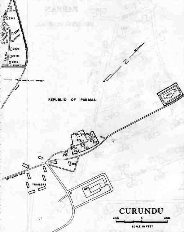