Talk:Project 596
| A fact from this article was featured on Wikipedia's Main Page in the On this day section on October 16, 2017, October 16, 2019, October 16, 2021, and October 16, 2023. |
| This article is rated Start-class on Wikipedia's content assessment scale. It is of interest to the following WikiProjects: | ||||||||||||||||||||||||||||||||||||||||||||||||
| ||||||||||||||||||||||||||||||||||||||||||||||||


Wiki Education Foundation-supported course assignment edit
![]() This article is or was the subject of a Wiki Education Foundation-supported course assignment. Further details are available on the course page. Student editor(s): Davidxyz. Peer reviewers: Cmedvid, Emily rodriguez.
This article is or was the subject of a Wiki Education Foundation-supported course assignment. Further details are available on the course page. Student editor(s): Davidxyz. Peer reviewers: Cmedvid, Emily rodriguez.
Above undated message substituted from Template:Dashboard.wikiedu.org assignment by PrimeBOT (talk) 07:16, 17 January 2022 (UTC)
Co-ordinates edit
I've corrected the co-ordinates in the "specifics" section, but don't know how to do it at the top, where the link is. Can anyone help. The true site (round scar) is within a few hundred metres of the co-ordinates I have cited. —Preceding unsigned comment added by Theeurocrat (talk • contribs) 10:21, 6 October 2010 (UTC)
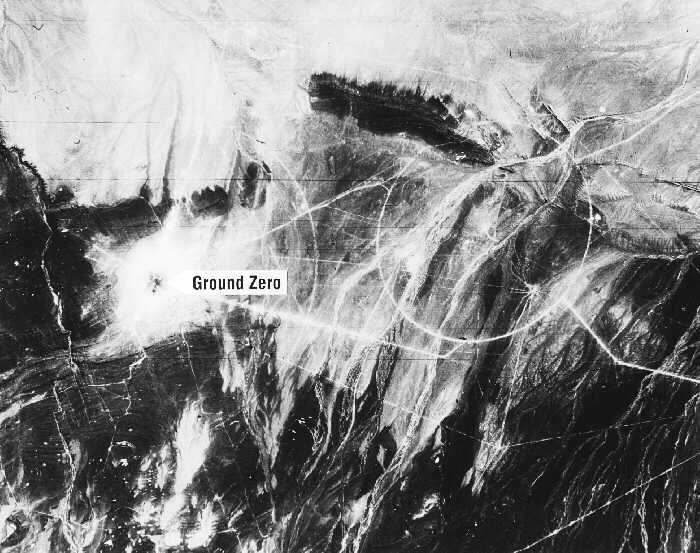
- Unfortunately, that round scar is not the site of 596. Based on the satellite photographs (http://nuclearweaponarchive.org/China/LopNor700c15.jpg) taken just after the blast, the correct coordinates (as far as Google earth can place them) is 40.8121,89.79386, about 2.8 km to the NW of the scar. The cause of the scar is unknown but obviously man-made; there were about 24 drops made in this area (known as the drop area of Lop Nur, separate form the underground test areas of Nanshan, Beishan and Qinggir), 16 of which have no known coordinates, and for which no ground proof seismic disturbances have been noted (including 596 itself). These unplaced drops were up to 3 MT in yield, and might be responsible for the scar. See http://www.rdss.info/cgi-bin/resdb_ent?dbtype_id=GTD SkoreKeep (talk) 06:50, 4 March 2013 (UTC)
- PS: A close look with the latest data in Google Earth shows a faint circular scar around the new placement as well. I didn't see that until after editing the page. :) SkoreKeep (talk) 07:05, 4 March 2013 (UTC)
- Very good sleuthing, Skorekeep, and that is a great tool. An ex-Air Force friend of mine has already told me that the scar I mentioned is no scar at all, but rather a bombing target. There is another one a few miles west. As to the 596 site, we reckon it is about 500 metres west of the point you calculate, and probably within the margin of error of the tool - if you go into Bing Maps, you can clearly see the base of the tower, the instrumentation bunker, and even the road that the device was rolled down.Theeurocrat (talk) 13:22, 25 April 2013 (UTC)
Photo of the mock-up bomb edit
I think that this cannot be the right photo. 596 was a tower shot, and there are small pictures of it as a large cylindrical object being pushed down a road to the site. Perhaps the image shows an early weaponised device derived from 596, but it cannot be 596 itself. Skorekeep, any comments? Theeurocrat (talk) 13:22, 25 April 2013 (UTC)