A fact from Concession road appeared on Wikipedia's Main Page in the Did you know column on 11 June 2004. The text of the entry was as follows:
|
| This article is rated Start-class on Wikipedia's content assessment scale. It is of interest to the following WikiProjects: | |||||||||||||||||||||||||||
| |||||||||||||||||||||||||||


Hmm -- in Bruce County our concession numbering system is different -- same with Grey and Huron Counties too I think. Each concession is actually two concessions, one for each side of the road, however road signage only refers to the even number (concession 2, 4, 6, etc). Updated this entry to reflect this --Dalar 07:54, 4 December 2005 (UTC)
Improvements/Corrections Suggested edit
Several things wrong with this article:
1) The 1-1/4 x 1-1/4 grid is typical of only some surveys, for example in "most" of York region. Southern Peel was on this system, but northern Peel is on a different size grid, which is why arterial roads don't always line up. (Cawthra road ends at Eglinton; similarly McLaughlin and Kennedy have noticeable jogs where they were extended south of Eglinton)
- See the sidebar in this article: Canadian Encylcopedia "In this version of the Ontario land survey, the 1000-acre block is 5/6 of a mile wide and 1 7/8 miles long."
- Also, here, page 52. Each farm is 3/8mile wide by 5/12 mile deep. Two farms are back to back on a lot, making the concession 10/12 = 5/6 mile wide. 5 farms are in a block, making it 15/8 = 1-7/8 mile "tall".
2) In York, concession roads are North-South (run perpendicular to the lakefront), and sideroads are east-west. The article seems to imply the opposite. Large parts of York, Peel, Halton had N-S lines, E-W sideroads. whitchurch stouffville [1]
Some townships, for example Tecumseth in Simcoe County, were noticeable numbered the "opposite" way -- sideroads N-S and lines E-W
- I think the conclusion would be either N-S or E-W.
3) Different numbering systems were used
For example in York, Yonge Street was the "middle" North-South road.
There was no "zero" line; Yonge was in effect "first" but was never called thus)
The first north-south road to the west of Yonge (today called Bathurst) was called "second concession"
(perhaps more formally it was the "line between first and second [land] concessions"
King Township had 13 concession roads.
The first east-west sideroad was numbered 14, the next north 15 and so forth (sideroad numbers not derived from lot numbers) so each road had a unique number (2-13 for N-S; 14 to 20 for E-W roads)
In other counties, the "middle" North-South road was "zero"
For example Hurontario street.
The first N-S road to the west of Hurontario (today called McLaughlin) was "1st line west" or "1st line WHS" (west of Hurontario Street)
4) Sometimes "concession" refers to the land area, and sometimes to the road.
In the York example above, first "land" concession is between Yonge and Bathhurst.
5) A large number of "numbered" roads in Ontario have been "named" in the last 20 years or so, perhaps as a requirement of 911 service.
Sometimes the old numbering no longer made sense.
For example in Peel, old townships of Caledon and Albion were merged into town of Caledon, making the old numbering system confusing.
Another example in Peel is "9th line" and "10th line" in Missisauga were annexed from Halton, and retain the old Halton numbering.
6) Sometimes special settlement roads were overlayed on the orignal survey grid.
For example Sydenham road from Shelburne to Chatswoth (highway 10 follows) is a diagonal overlayed on the original (roughly) N-S grid;
I think there are one or two lines that follow the diagonal. (depending on the township)
7) Line versus Concession
For whatever reason, the N-S roads in King Township were known as "concessions" and not as "lines".
In Peel they seem to be called "lines"
Feldercarb (talk) 18:22, 26 December 2010 (UTC)
- There are a lot of nuances in concession roads. Basically, they were originally laid out east and west (the frontage survey or single-front) along the shore of Lake Ontario. Then, in the early 1800s (and some cases in the late 1700s), meridian lines were driven into the wilderness (these were complimented by the colonization roads in the 1850s). These include Yonge Street, Hurontario, the Frontenac road, and what is now Highway 28 through Northumberland, amongst many others. From here, concessions were laid out east and west of the medidians, running north and south. Concession roads, however, are roads which portrude from the meridians to travel through the concessions. This is how most of the townships that front Lake Ontario are surveyed. Lake Erie was a different story, as the Talbot Road forms the baseline rather than the lake itself.
- As for the 1 1/4 mile, thats based on the gunthers chain. 6600 feet plus a 66 foot road allowance made up each concession, and this is true in about three quarters of southern Ontario. I still have to read more into why Durham and many of the counties east of York used a different system. However, Peel, York, and Halton counties are all based on the same surveying standard, they're just oriented towards the lake. - ʄɭoʏɗiaɲ τ ¢ 18:49, 26 December 2010 (UTC)
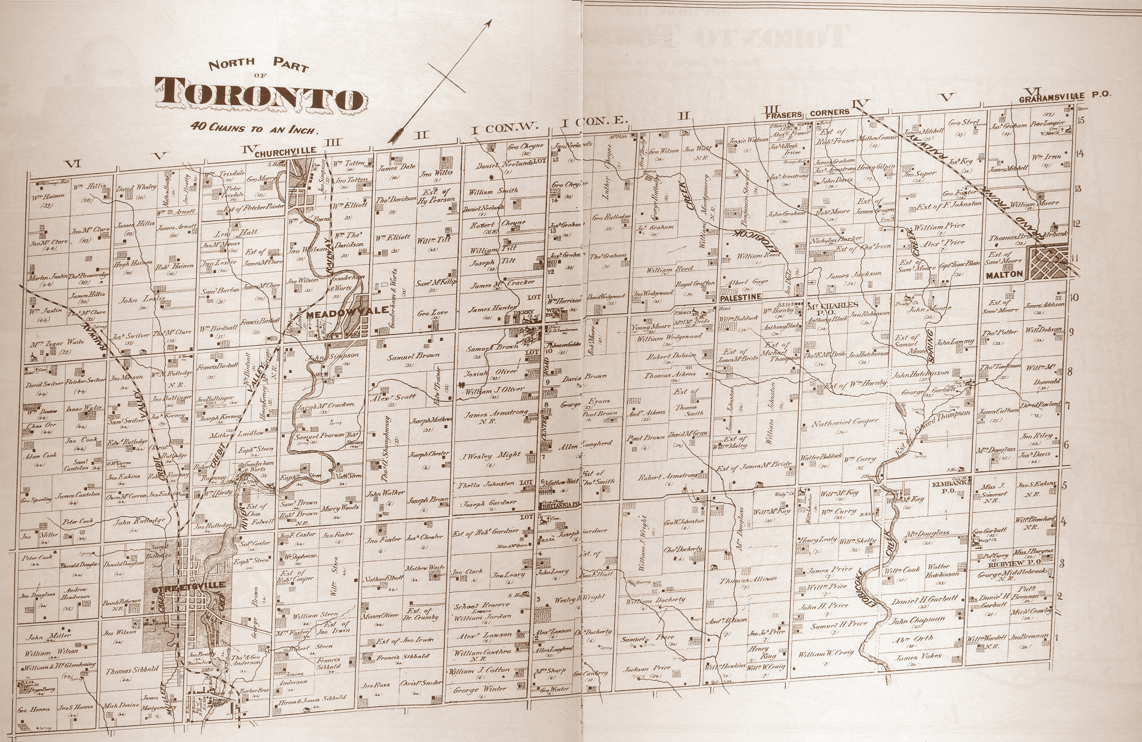
Clearly northern peel is NOT on the 1-1/4 mile system.
Look at the distance between Hurontario and Kennedy (former 1st line EHS)
Now look at the distance between Britannia and Derry (both former sideroads)
map of former Toronto township (mississauga today)
You can see the same at Rosemont ON, clearly the grid is not square Feldercarb (talk) 20:50, 21 April 2012 (UTC)
You can see Etobicoke (McGill Map)had several different grids:
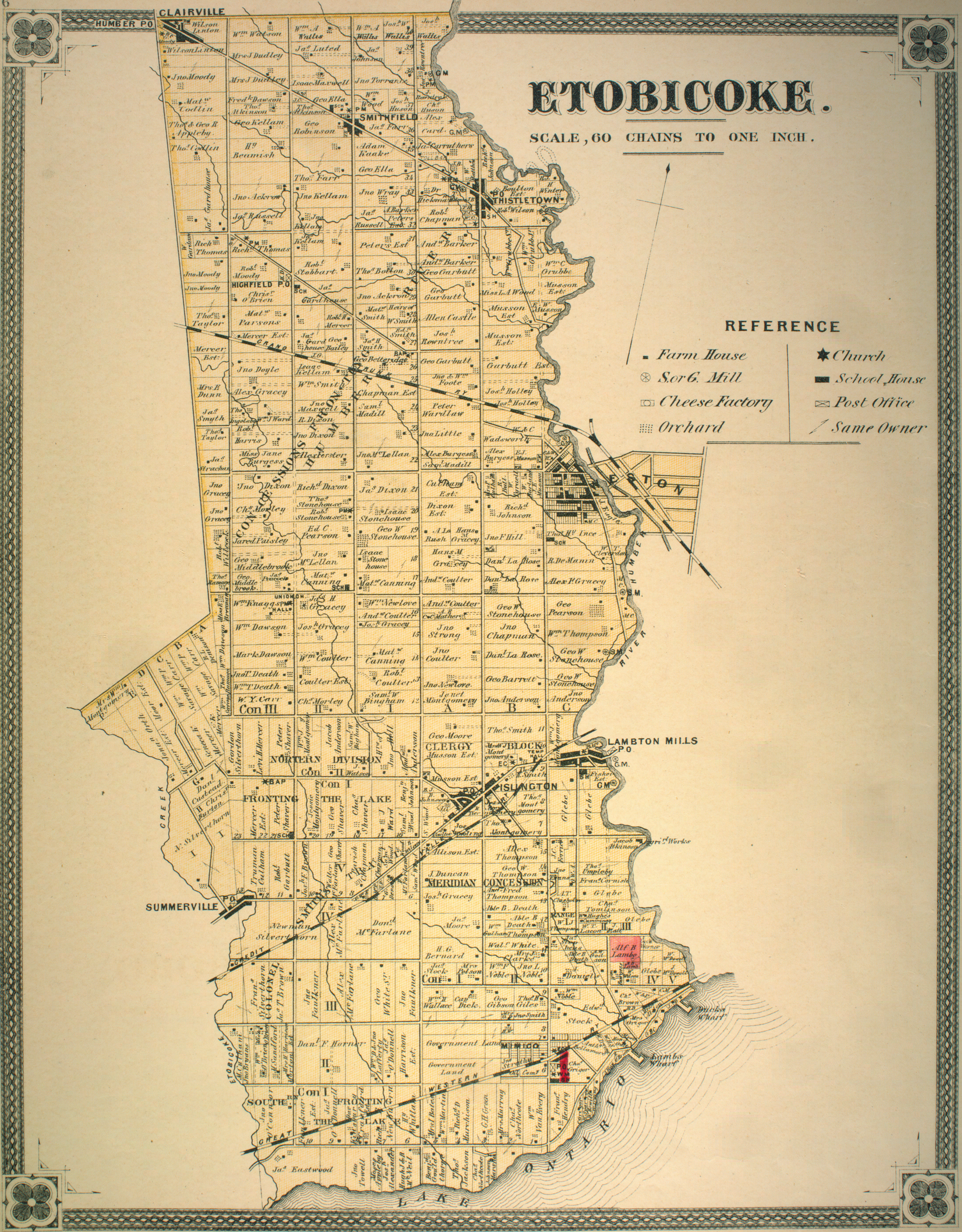
- South Fronting the Lake -- aligned to the lake, concession roads run E-W
- North Division Fronting the Lake -- a second division aligned to the lake, concession roads run E-W
- Concessions Fronting the Humber -- concession roads run N-S
- Meridian Concession -- concession roads run N-S
- none of the blocks are square -- they are rectangular
Look more carefully at your McGill map -- you can see across the top that the concession roads are N-S. (the I concession is the vertical strip of land). The solution to the riddle is that Toronto used more than one grid or survey. The first survey in the south had E-W concession roads. Above Eglinton, it flipped to N-S. My point is, this article is too simplistic.
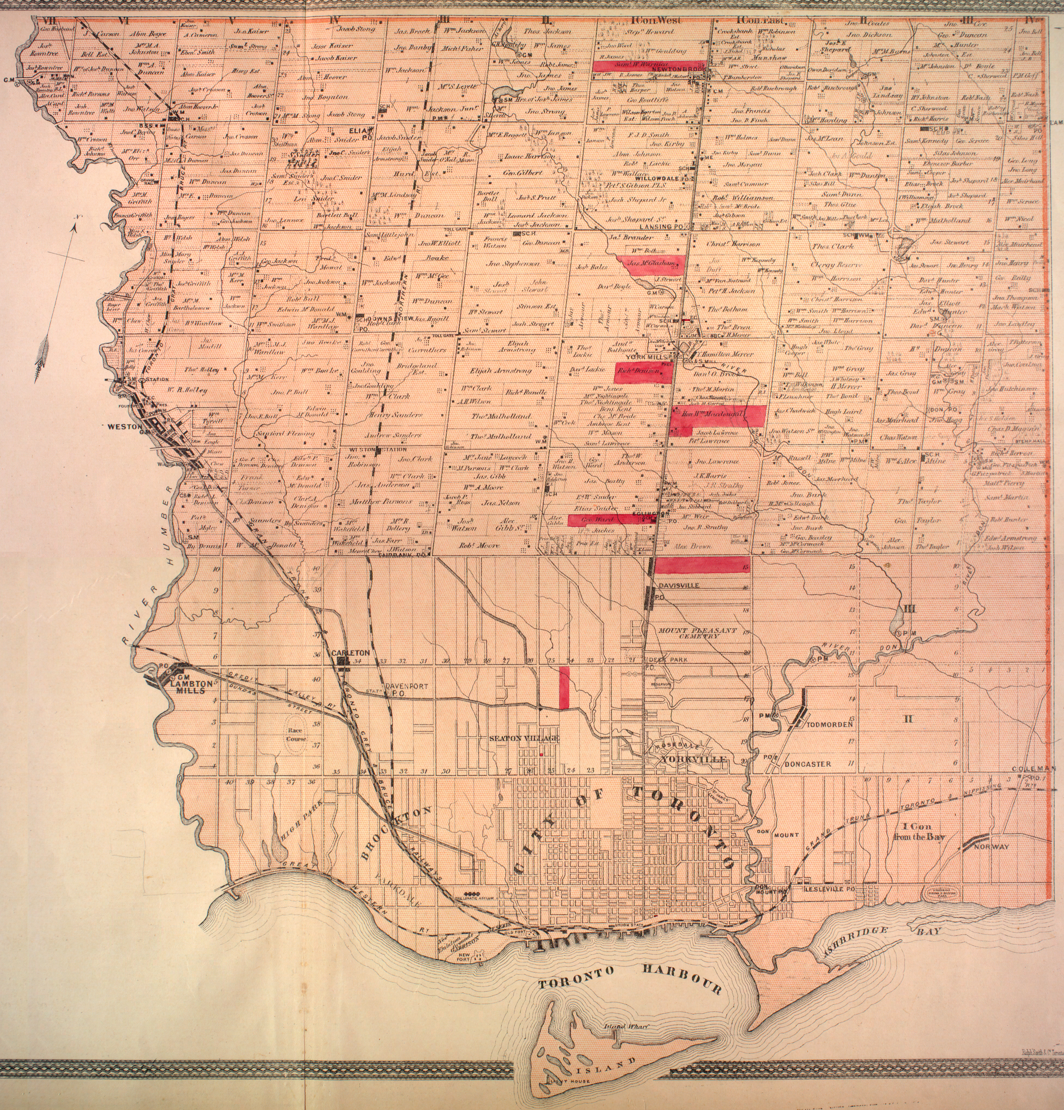
Also, Bathurst was 2nd line in King Township:
- Look at a map of King Township Pottageville Map -- 7th concession (King still happens to use numbered roads)
- Look for Pottageville, which is on the 7th concession road
- Now count backwards, going east towards Yonge street
- 6th = Weston Rd
- 5th = Jane
- 4th = Keele
- 3rd = Dufferin
- 2nd = Bathurst
Technically, Bathurst is the line road between 1st and 2nd concessions; but in King the local parlance is the road is called "the second" or the "second concession" Also please notice, the 7th concession road is clearly a North South road, not east west :) Feldercarb (talk) 20:50, 21 April 2012 (UTC)
Perhaps we're approaching this subject the wrong way... edit
Concession roads seem to be a facet of the larger idea of concessions... That being strips of land divided into lots during the surveying of a township. Would anyone be opposed to the renaming of this article to Concession (surveying), and the shifting of the prose to discuss the land lots as well as the roads cleared in front of those lots by statute labour. - Floydian τ ¢ 18:53, 27 September 2012 (UTC)
I don't think that's helpful. If people are trying to find out about rural road terminology, in order to make sense of driving directions (eg. "turn onto the 3rd line and go south on the 10th sideroad") they are probably not interested in detailed info about surveying. It might confuse them, learning how to drive around in rural areas is confusing enough as it is! Hyacinth45 (talk) 23:19, 23 July 2014 (UTC)
External links modified edit
Hello fellow Wikipedians,
I have just added archive links to one external link on Concession road. Please take a moment to review my edit. If necessary, add {{cbignore}} after the link to keep me from modifying it. Alternatively, you can add {{nobots|deny=InternetArchiveBot}} to keep me off the page altogether. I made the following changes:
- Added archive https://web.archive.org/20140411013829/http://www.mnr.gov.on.ca/stdprodconsume/groups/lr/@mnr/@osg/documents/document/stdu_130769.pdf to http://www.mnr.gov.on.ca/stdprodconsume/groups/lr/@mnr/@osg/documents/document/stdu_130769.pdf
When you have finished reviewing my changes, please set the checked parameter below to true to let others know.
This message was posted before February 2018. After February 2018, "External links modified" talk page sections are no longer generated or monitored by InternetArchiveBot. No special action is required regarding these talk page notices, other than regular verification using the archive tool instructions below. Editors have permission to delete these "External links modified" talk page sections if they want to de-clutter talk pages, but see the RfC before doing mass systematic removals. This message is updated dynamically through the template {{source check}} (last update: 18 January 2022).
- If you have discovered URLs which were erroneously considered dead by the bot, you can report them with this tool.
- If you found an error with any archives or the URLs themselves, you can fix them with this tool.
Cheers.—cyberbot IITalk to my owner:Online 21:22, 7 January 2016 (UTC)
examples edit
As we point out, there is some crazy number of variations. I would like to give a "few" examples here, to give people the idea, but I imagine most systems could be detailed in the "township" articles. I picked:
- King township - single front, 1-1/4 mile square blocks, still uses numbered concessions and sideroads. Same system as most of York region.
- Peel region - double front, 1-7/8 rectangular blocks, uses East/West system
Update July 2021: If I can re-iterate: I tried to pick two areas with differing systems as general examples. (I will admit some bias in the selection of these two, as I lived in both areas.) For specific examples, I think the information could be placed elsewhere in existing township/town/road articles.(eg Highway 27 in King was on 9th concession road, should be in King article, or Hwy 27 article). Feldercarb (talk) 15:28, 25 July 2021 (UTC)
I am looking for edit
I'm looking for citable reasons why many concession/side roads have been named instead of numbered. I can think of several reasons:
- people prefer names;
- city folk move to country and don't understand;
- numerous survey systems to start with;
- townships merged or renamed {eg Nassagaweya township disappeared but road signage lives on}
- 911 system demanded less confusing names;
But I have few items to support the above.Feldercarb (talk) 17:17, 12 July 2022 (UTC)
- Many were for a building or feature located along them near the Meridian road of the survey (you school roads, airport roads, etc. The 911 system definitely played a big part since many roads were simple ordinal names until the 1990s. I'd start your search with that. - Floydian τ ¢ 18:02, 12 July 2022 (UTC)