| This article is rated Start-class on Wikipedia's content assessment scale. It is of interest to the following WikiProjects: | |||||||||||
| |||||||||||

Two words or one? edit
I have changed bench mark to benchmark throughout merely for consistency with the title (and the Concise Oxford Dictionary). However, the Ordnance Survey (and Collins Dictionary) spells this as two words.--Shantavira|feed me 18:06, 24 November 2007 (UTC)
Professional surveyor usage for elevation control points in the US is two words "bench mark" and it is not applied to any other type of survey mark. The single word is often used in a loose sense by the geocaching community to include any survey mark. The single word is also used in non-technical speech for any standard of comparison, such as for computer performance testing. I would support a change to the two word form in this article based on US terminology, but am not familiar with usage in the rest of the world. BillHart93 (talk) 21:35, 30 December 2014 (UTC)
- I recently reverted an anon who went through and "corrected" it all to the two-word variant. If you think that's a good idea, an RM discussion might be a good way to bring it up, so we keep the title and text in sync. The USGS is not consistent, but seems to mostly use "benchmark"; see search. Dicklyon (talk) 22:02, 30 December 2014 (UTC)
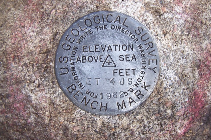
- The USGS disks have two words. That should take precedence over anything someone in the agency might have written. See http://surveyorconnect.com/images/uploaded/2014123117361654a434100e73e.jpg BillHart93 (talk) 17:54, 31 December 2014 (UTC)
I checked some of my reference books. Vanicek and Krakiwsky's Geodesy: The Concepts, Davis, Foote, Anderson, and Mikhail's Surveying Theory and Practice, Mikhail and Moffit's Photogrammetry, and The American Practical Navigator (NGA-published) all use bench mark. Moffitt and Bouchard's Surveying, Canadian Tidal Manual, and Admiralty Manual of Hydrographic Surveying use benchmark. Melitak (talk) 17:52, 31 December 2014 (UTC)Melitak
"fixed point" edit
The disambiguation page for the term "fixed point" suggests that this page will explain the term fixed point as used in the context of surveying. Anyone want to take a crack at that, either here or on a new page named "fixed point (surveying)"? Once that's done I can point Geodetic network and Meridian arc, which currently points out to the fixed point disambiguation page, to wherever the explanation ends up. Thanks! --Joe Decker (talk) 05:58, 6 May 2010 (UTC)
Image deleted edit
I deleted a photo of a carved arrow apparently on Chapel Well in Irvine which the uploader claims is a bench mark. Not only does it not have a datum (an obvious requirement) but it is not listed by the Ordnance Survey and is not shown on any map, the nearest bench mark being on the local church tower. There are several marks, such as crosses, carved on the walls near Chapel Well, this is just another of them.--Shantavira|feed me 16:52, 28 January 2015 (UTC)
I don't know that locality, so won't revert, but the arguments are not conclusive to me. The point of the arrow could be taken as the datum point. Marks may be derived for convenience (either from government marks or by assuming a local datum) and be in local usage even though they are not in a government list or on official maps. BillHart93 (talk) 17:20, 28 January 2015 (UTC)
External links modified edit
Hello fellow Wikipedians,
I have just modified one external link on Benchmark (surveying). Please take a moment to review my edit. If you have any questions, or need the bot to ignore the links, or the page altogether, please visit this simple FaQ for additional information. I made the following changes:
- Added archive https://web.archive.org/web/20080225204753/http://87.30.244.175:80/index.php to http://87.30.244.175/index.php
When you have finished reviewing my changes, please set the checked parameter below to true or failed to let others know (documentation at {{Sourcecheck}}).
This message was posted before February 2018. After February 2018, "External links modified" talk page sections are no longer generated or monitored by InternetArchiveBot. No special action is required regarding these talk page notices, other than regular verification using the archive tool instructions below. Editors have permission to delete these "External links modified" talk page sections if they want to de-clutter talk pages, but see the RfC before doing mass systematic removals. This message is updated dynamically through the template {{source check}} (last update: 18 January 2022).
- If you have discovered URLs which were erroneously considered dead by the bot, you can report them with this tool.
- If you found an error with any archives or the URLs themselves, you can fix them with this tool.
Cheers.—InternetArchiveBot (Report bug) 20:01, 30 October 2016 (UTC)
Broad arrow edit
I had not realised until reading this other article and this one that the arrow device on benchmarks originated as it did, i.e. to mark government property - that would be worth including in this article, suitably referenced I think. Geopersona (talk) 17:14, 18 June 2020 (UTC)
- I'm not convinced that this is the origin of the mark. It could be also be a depiction of a tripod with levelling instrument. Gollem (talk) 18:23, 19 June 2020 (UTC)
- Or both? Hence the need for a suitable reference . . . cheers Geopersona (talk) 21:48, 19 June 2020 (UTC)
- The use of the broad arrow as a symbol of the Board of Ordnance is well documented at Broad arrow. It's got nothing to do with a tripod.--Shantavira|feed me 13:34, 27 January 2021 (UTC)
- The Board of Ordnance and other government agencies didn't use the symbol with the horizontal line like the Ordnance Survey, right? It seems likely that there is a connection between the two symbols, but I didn't see a citation for the assumption that the Ordnance Survey benchmark symbol originated from the broad arrow. And if it originated from the broad arrow, it is possible that the horizontal line was added for the resemplence of a levelling instrument on a tripod. A reliable source would help to clarify. Gollem (talk) 21:55, 27 January 2021 (UTC)